
-
 25493 Hits
-
 88.61% Score
-
 27 Votes
|
|
Area/Range |
|---|---|
|
|
47.26630°N / 13.76040°E |
|
|
Hiking, Mountaineering, Trad Climbing, Skiing |
|
|
Spring, Summer, Fall, Winter |
|
|
9393 ft / 2863 m |
|
|
What's new On This Page?
- January 8th, 2019: design corrections.
- November 23rd, 2012: Google map (with all summits on SP) embedded.
The Purpose of This Page
On this page I would like to give an overview information of Niedere Tauern group in order not to be repeated on all distinct summit pages.
Overview
View Niedere Tauern in a larger map
Niedere Tauern (in English: Lower Tauern) is a mountain group, belonging to Eastern Alps. See there a broader overview! As a part of the central chain of Eastern Alps they are mainly built of harder rock structures, unlike for example the North Limestone Chain. But being also some 800 meters lower than the neighbouring Hohe Tauern, their appearance is not so wild, and there is also no glaciers in Niedere Tauernern. The western border of Niedere Tauern is Grossarltal (valley) and the Murtoerl (saddle), where they meet the Ankogel Group of Hohe Tauern. Towards north the group of Niedere Tauern is clearly divided from groups of North Limestone Chain: Salzach river to St. Johann, Wagrainer Bach (creek) and further to Wagrainer Hoehe (saddle), down to Enns valley and following this beautiful river all the way to Liezen. Also the south border is clear - it is the dark Mur river from its source to Leoben. And finally on the east two creeks (Palten and Liesing) and the Schoberpass (saddle) form the border to the neighbouring Eisenerzer Alps. On the whole Niedere Tauern extend for 75 miles (120 km) in a west-east direction. From west to east Niedere Tauern consist of the following four subgroups (in brackets the highest peak):
- Radstaedter Tauern (Weisseck, 2711 m); from Grossarltal to Tauernpasshoehe (Obertauern pass),
- Schladminger Tauern (Hochgolling, 2863 m); from Tauernpasshoehe (Obertauern pass) to Soelkpass,
- Rottenmanner Tauern (Gr. Boesenstein, 2448 m); from Soelkpass to Hohentauernpass,
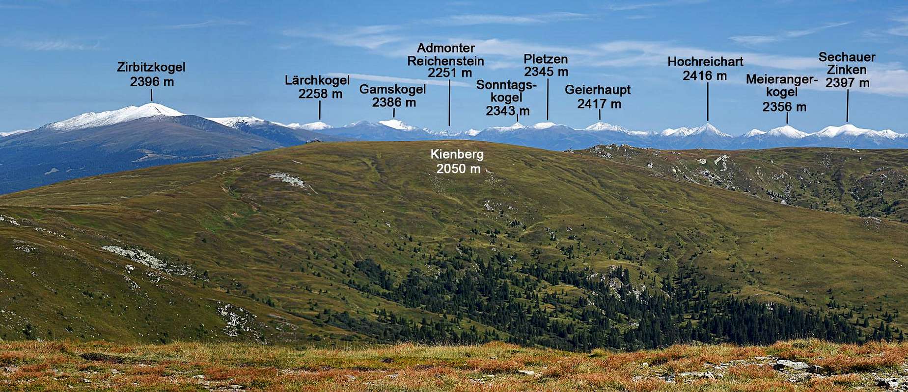
- Seckauer Tauern (Geierhaupt, 2417 m); from Hohentauernpass to Schoberpass.
The highest summit of Niedere Tauern, Hochgolling, 2863 m, is a nice, massive mountain with sharp ridges and a huge, 1200 meters high north face.
 |  |  |
Getting There
For airports and highways see the broader Eastern Alps page. The group is best accessible by two highways - on the west Tauern highway (Villach - Salzburg) and on the east Pyhrn highway (Graz - Linz). There are good roads along both main rivers (Enns and Mur), across all the above mentioned passes and also from north and south into many valleys of the main chain. In both main valleys there are also train connections. On the web, you can see a detailed map on: http://www.austrianmap.at/.
Places Of Interest
Grossarltal is a nice valley, which was long time connected with rest of the world over the mountain pass and the neighbouring (on the west) Gasteiner Tal. The valley begins with the most picturesque, wild gorge in Eastern Alps, named Liechtenstein Klamm. It is arranged for tourists visit. Otherwise Radstaedter Tauern are different from the other three groups. Their rock and appearance is similar to Italian Dolomites, so there you can find some wild, rugged peaks, appropriate for climbing (Faulkogel etc.). See also the Mosermandl page! In northern parts of Radstaedter and Schladminger Tauern there are broad ski resorts. In the past everybody knew Annemarie Moser-Proell from Kleinarltal, nowadays everybody knows Hermann Maier from Flachau. Also tourist resorts like Flachau, Zauchensee, Schladming and others are known worldwide. Schladminger Tauern are also famous by their lakes. Hundreds of them make a landscape scenery of superb beauty, worth of long, more days hiking. And the most beautiful lake scenery is on Klafferkessel, with its surroundings now being protected as a natural park. Schladming Tauern are also appropriate for higher mountain tours, scrambles and easy climbing, offering also great panorama on northern mountain chains (Dachstein) towards west to glaciers of Hohe Tauern and towards south and east on the sea of mountains of Kaernten and Steiermark. The other two groups, Rottenmanner Tauern and Seckauer Tauern are a bit less attractive, of corse it depends on an individual taste. Mountains there are a bit lower, milder, but also offering great hiking possibilities. If anything, in winter and spring all Niedere Tauern are a paradise for tour skiing. Still considerable heigth differences and on all sides appropriate slopes enable thousands of first class ski tours. If you for example ascend with skis the Preber, 2741 m on a beautiful March day, you will be among hundreds of tour skiers with the same interest. But that's on most popular summits, on others, you will still be alone.
     |
Red Tape
About the Niedere Tauern National Parc there is not much information. Nature is protected in a broad area (125 square km) of the main ridge of Schladminger Tauern. Crossing mountain passes is toll free (but you pay tunnels on Tauern highway). Roads into many valleys are closed for public traffic or toll is to be paid.
When To Climb
You can climb Niedere Tauern mountains in any season. In winter many of them will be very demanding. Have in mind that this mountain range is an important barrier for winds, so weather conditions are on the southern and on the northern side frequently very different. For weather conditions for Austria see here (then choose regions: Salzburg, Steiermark and Kaernten). Avalanche info pages are the following: For Steiermark, For Salzburg, For Kaernten.
Camping
All surrounding valleys are well developed for tourism. You can stay there in many hotels and some camping places. Niedere Tauern are also very well covered with mountain huts - too many to list them all here. They will have to be named on every separate summit page. Among towns around Niedere Tauern I have found the following ones with web pages: Groebming, Judenburg, Knittelfeld, Leoben, Murau, Radstadt, Rottenmann, Schladming, St. Johann, Tamsweg.
 |  |
Miscellaneous Info
Our member dedo recommends this guide book for Niedere Tauern: Peter Holl: Niedere Tauern Alpenvereinsführer.