
-
 5805 Hits
-
 87.31% Score
-
 24 Votes
|
|
Mountain/Rock |
|---|---|
|
|
47.02626°N / 13.12617°E |
|
|
Hiking, Mountaineering, Scrambling, Skiing |
|
|
Spring, Summer, Fall, Winter |
|
|
8842 ft / 2695 m |
|
|
Overview

SW slopes
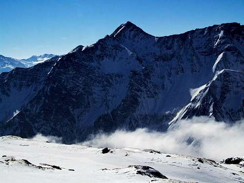
Rameterspitz is one of those mountains which during the season gets only a moderate attention, but when times for tour skiing begin, many joyful mountaineers ascend it. It is standing in the main ridge of Hohe Tauern, in the part, where the Goldberg group is passing its hand do the Ankogel group, just north-west of the well known tourist resort of Mallnitz.
It is not a remarkable posture itself. Perhaps it looks nicer from the northern side, from the south it is just another elevation in the main Hohe Tauern crest. Even if in the main Hohe Tauern ridge there are a few higher mountains nearby, Rameterspitz offers a great panorama on all sides. The name is written also Rameter Spitz or Romate-Spitz.
A Bit Of Geography
The scenery on the ascent on Rameterspitz
As the northern slopes of Hohe Tauern main crest are a bit steeper here than the southern ones, over the latter more ascents go. North of Rameterspitz is Badgastein, the town, where the main valley branches into Anlauftal and Sportgastein valley. While the first one rises towards the east to the summit of Ankogel, the valley at Sportgastein branches again and the main branch turns towards the east below the main Tauern ridge just to Rameterspitz and Woisgen Kopf. I have no information how Woisgen-Scharte, 2443 m, is reachable from this valley. That would be one possible ascent on Rameterspitz from the north, the other obvious one is of course over the Mallnitzer Tauern.
On the southern side from Mallnitz a nice valley, called Tauerntal goes towards the west. From Jamnig-Huette the main path goes towards the NW over Mallnitzer Tauern (pass), but from there over the southern slopes of the whole Main Tauern crest the well beaten marked path goes towards Rameterspitz and further on. This is Zentralalpenweg / Tauernhoeheweg / Hagener Weg. It reaches the southern ridge of Rameterspitz from where it is just a short walk-up to the summit.
From the Mallnitzer Tauern / Niederer Tauern, where the Hagener Huette stands, in the Main Tauern crest the following summits are rising: Greil Kopf, 2583 m. The summit is easilly reached from the west, from Hagener Huette. This can also be done as a ski tour. Ebeneck, 2533 m. As its name suggests, the mountain is flat on the top. In times of tour skiing you can ascend over its southern slopes the west ridge and follow it to the top - another possible ski tour in this area. East of Ebeneck there's a distinct Ulschartl (notch), 2490 m. Rameterspitz, 2695 m. Reachable by Laschgbach valley and the southern summit slope.
On the summit, the main crest turns towards the NE and descends on Woisgen-Scharte, 2443 m. Woisgen Kopf, 2708 m. Goettinger Spitze, 2749 m. Gamskarl Spitze, 2832 m. Grueneckersee Spitze, 2612 m. East of it on Hoher Tauern, 2460 m, the Goldberg Group ends.
Summit View
No doubt, the most attractive part of the summit panorama is the view on Hochalmspitze west face. The Tauern Queen is beautiful from all sides, yes, but the sharp rocky structures and steep couloirs of its western face are something special. Ankogel is being seen along the main ridge, so it doesn't stand out so magnificently. Still, its high posture is worth of a long look.
To the other, western side, you'll need some time to realise, that the high peak above Weissenbach valley is Schareck, and right next to it, there's already Sonnblick. Also a bit lower 3000-ers towards the east, finishing finally with the sharp Geisselkopf, 2974 m, are a nice scene too. And towards the SW, in the long ridge beyond Tauerntal, the sharp Boeseck is a nice posture too.
Towards the south-east Julian Alps are seen in the distance, towards the south also Kreuzeck group and on the other side, on the nothern horizon you can admire Berchtesgadener Alps and towards the north-east Tennengebirge and Dachstein, to name only some groups.
 Ankogel and Hochalmspitze |
 Berchtesgadener Alps |
 Towards Dachstein |
Getting There
The northern side. Gasteiner valley can be reached from the Salzach valley, driving towards the south. You leave the Salzburg-Villach highway near Bischofshofen, pass St. Johann and then turn southwards. In Badgastein you can deter south-westwards to Sportgastein, 1640 m.
The southern side. Mallnitz can be reached from the Moell valley, driving northwards. You leave the Salzburg-Villach highway near Spittal, and drive by rivers Drau and Moell towards the NW till Obervellach. There you turn northwards and reach the high valley of Mallnitz by a good road. Mallnitz can of course be reached also from the northern side - in Badgastein (actually Boeckstein) you can put your car on the train and reach Mallnitz through a tunnel. From Mallnitz, you can drive with your car a few kilometers more into Tauerntal. In winter and spring the road is closed at Stockeralm, 1290 m (a big parking place). From there you can take a ski bus, which brings you up to 1670 m, where below Jamnig-Huette there's a parking place. The bus goes for at least 3 persons and costs 4 EUR (officially 5 EUR). This part of the road you can usually ski down, as it is arranged also as a sledge piste. In summer you might be also able to drive up to the parking place below Jamnig-Huette.
Routes Overview
3. From Mindener Huette, 2428 m
If you are heading westwards by Zentralalpenweg, from Mindener Huette towards Hagener Huette, you will first pass Woisgen Kopf and soon reach the southern ridge of Rameterspitz. Frome there the summit can be reached in some 15 minutes. From Mindener Huette 1 good hour.
4. From the northern side
From Sportgastein, 1640 m, north of the main Tauern crest, the most obvious route goes over Mallnitzer Tauern. It can be reached in some 2 hours 30 minutes. From the saddle to the summit of Rameterspitz you have then some 1 h 30 min more, as described under #2. Another possibility would be a scramble by Weissenbach valley to Woisgen Scharte and back by the Zentralalpenweg on top. I have no information how this would be difficult. You can see a detailed map (1:50.000) on-line on: http://www.austrianmap.at/.
 Skiing |
 Skiing |
 Winter scene |
Red Tape
No limitations.
Huts And Camping

You can have all tourist facilities in Mallnitz and Badgastein/Sportgastein. Higher on the mountain there are three official mountain huts:
- Jamnig-Huette, 1748 m. Opened in summer.
- Hagener Huette, 2446 m. Opened from start of Juli till start of October. 16 beds 27 sleeping places, winter room with 6 places (opened). Tel.: 0664/4036697, in the valley: 04732/4290.
- Mindener Huette, 2428 m. A self-supply hut, opened from mid June till mid September. 12 places. Tel. (in the valley): 0664/1549840.
When To Climb?
In good conditions, Rameterspitz can be ascended any time of the season. In summer and autumn it is a goal of long-distance hikers and also a one-day objective. In times of tour skiing it is a perfect goal too, in normal winters the best time for a tour would be March - May. In 2007, when winter was poor with snow, we had perfect conditions mid February.