|
|
Mountain/Rock |
|---|---|
|
|
47.07640°N / 12.93750°E |
|
|
10675 ft / 3254 m |
|
|
Overview
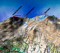
Hocharn is the highest Peak of the Goldberg Group (which is part of the eastern "Hohe Tauern Range"). The mountain is covered by the Krumml Glacier in the north, the Hocharn Glacier in the east and the Fleiss Glacier in the West. As there are no huts on the mountain the number of ascents is much smaller than at the nearby Sonnblick. ) Several routes lead to the top. The most common one starts at Kolm Saigurn (an old gold digger village at the end of the Rauris Valley) at the east side of Hocharn. This route requires a good physical condition (vertical distance 1700m) but has no technical difficulties. In autumn the Hocharn glacier might be icy and crampons will be necessary.Getting There
Hocharn can be either climbed from Salzburg (Rauris / Kolm Saigurn, east side) or Carinthia (Heiligenblut, west side).Kolm Saigurn: From Munic or Salzburg take the A10 motorway till Bischofshofen and continue at the National Road to Taxenbach. Here you branch off into the Rauris Valley. At the end of the valley a toll road continues to a parking place close to Kolm Saigurn. In case you stay at the Ammerer Guest House at Kolm Saigurn you are allowed to drive further 1,5km into the valley. For those who travel with public transports: Take the train to Taxenbach. At Taxenbach buses leave to Kolm Saigurn. The intervals between the buses might be rather long.
Heiligenblut: Heiligenblut is one of the most famous mountain villages of Austria at the end of the Möll Valley. The village is starting point for the Grossglockner, Austria´s highest peak and for the fantastic Grossglockner road which connects Carinthia with Salzburg.
To get to Heiligenblut also take the motorway A10, leave it at Spittal and follow the national Road to Heiligenblut. From South Tyrol / Italy leave the motorway near Brixen /Bressanone, Exit Pustertal, follow the National Road to Lienz, drive over the Iselsberg (mountain pass) into the Möll Valley.
Closest train stations are Lienz and Mallnitz. Heiligenblut can be reached with public buses (time consuming).
An online train time table can be found at:
ÖBB
Red Tape
Although Hocharn is located within the Hohe Tauern National Park no fees have to be paid as long as you don´t go by car. At Rauris (Bodenhaus Restaurant, large parking place for climbers and hikers) a toll road brings you a 4 km further into the valley (and 300m higher). At the end of the toll road you have to pay for the parking again!In case you are going to approach Hocharn via the west ridge (Klagenfurter Jubiläumsweg) you might start from the Grossglockner road (Hochtor). This road is also a toll road (rather expensive, app. 30 Euros per car). There is also a bus connection to Hochtor.
When To Climb
The mountain can be climbed all over the year. For skiing the best months (most secure) are March to May (June) and for non skiers June to September are best.Camping And Accomodation
Camping is not allowed within the National Park. At the mountain base theAmmerer Hof Tel:0043/6544/8112, very recommendable and the
Naturfreundehaus (email: naturfreundehaus-kolm-saigurn@aon.at) are situated.
Zittel Haus (Tel: 0043/6544/6412 ) if you climb Hocharn via Sonnblick and Goldzechkopf
Otto Umlauft Bivouac box at the "Klagenfurter Jubiläumsweg"
Gold
Gold and Silver have been mined in this region for several thousands of years. The Roman writer Strabo gives the first record for gold mining in the region. Most probably mining activities started in Pre-Roman time like in many other places in Salzburg (copper in Muehlbach and salt at Hallein/Duerrnberg). In late medieval times Salzburg became the world´s largest producer of gold. Mining ceased at the end of World War II. Nowadays many topographic names remind us of the historic gold mining (Hoher Goldberg, Goldzeche, Goldzechkopf, Goldlacklschneid, Pochkar, Silberpfennig, Erzwies, Huettwinkel). Nevertheless gold can still be found at Hocharn and Sonnblick.At Hocharn the mines at the Goldzeche and at Grieswies-Schwarzkogel were most important. The underground workings reached heights of more than 3000m and are considered to be the highest gold mines of Europe.
In the 19th century the falling gold price and a climatic change (many mines were covered by glaciers) caused the closure of most of the gold mines.
There are still unmined economic ore bodies beneath Hocharn and Sonnblick. But as the impact of gold mining on nature and tourism would be too large the gold will remain in the mountains for all times.
Mountain Conditions
Till now no web cams have been installed. Informations can be given by:the Zittelhaus from the nearby Sonnblick Tel: 0043/6544/6412
Avalanche Bulletin
Ammerer Hof Tel:0043/6544/8112
Salzburger Nachrichten
ZAMG (weather forecast and online weather of Sonnblick)
Maps
The following maps will be useful:Alpenvereinskarte 42 (map of the Austrian Alpine Club, made by some of the best cartographers in the world, 1:25.000)
Österreichische Karte 153 (Austrian Map 1:25.000 and 1:50.000, also good quality)
Freytag & Berndt Karte WK 181
Freytag & Berndt Karte WK 193


Tomasz Jazwinski - Jul 21, 2013 1:18 pm - Hasn't voted
Correction to mapÖsterreichische Karte (Austrian Map) is # 154 (Rauris, 1:25,000). 153 is for Glockner Group