Martinswand
![Martinswand]() Martinswand
Martinswand
After a long holiday playing in the Alps, it was time to go home. Not too fast though, so, on my way north, I said my goodbyes to my friends and stopped at Zirl, near Innsbruck, to spend a few more days in the Karwendel.
![My lifeline on the Kaiser Max Klettersteig]() My lifeline on the klettersteig
My lifeline on the klettersteig
My first goal was the
Kaiser Max Klettersteig, a difficult aided climbing route on the Martinswand. I had read that the upper part was the hardest, but there was an exit from the route before that, at the so called
Maximilian-Grotte.
The climb was a great experience, but as I got closer to the grotto, I judged that my arms were used up too much to continue safely, so I bailed out. I'll have to go back there some day!
Ehnbachklamm
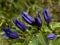
![Flowers in the Ehnbach canyon]() Flowers in the Ehnbachklamm
Flowers in the Ehnbachklamm![Memorial artwork]() Memorial artwork along the trail
Memorial artwork along the trailIn the afternoon, I hiked through the Ehnbachklamm (klamm=canyon) up to the
Solsteinhaus. I had called before to make sure they were open for business, because I new I would be arriving close to sundown and I wouldn't want to arrive at a closed hut that day.
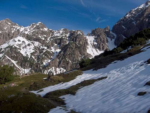
As I got higher, there was a bit of snow left from the bad weather a few days back. It was melting and my feet got wet. I found out that my hiking boots needed some repairs, as some serious holes had started to appear.
Eppzirler Scharte, or ...?
At the refuge, I enquired about the surrounding peaks, notably the
Erlspitze and
Großer Solstein. The warden said there was still quite a lot of snow up there, and nobody had ascended them recently. That's a pity, but so be it, no summits tomorrow then. Instead, I decided to go over the Eppzirler Scharte, a high pass into the next valley.
Next morning, all the trails around the hut were clear. The sun was out in force and it promised to be a beautiful day. I donned my mountaineering boots and set off on the trail to the pass.
The trail gained altitude very gently, and the snow started covering parts of it. There were no footsteps. Apparently nobody had been here recently. As I approached the pass, things got interesting. More and more snow on the trail, until it was totally covered up by the time I approached the ridge that I had to cross. The trail markers, which were mostly stones on the ground with some paint on it, were nowhere to be seen. So, which way to go?
Ascending the deeper snow in the gullies was hard work, and I really didn't want to find myself forced to come down again and try the other one! My map didn't help either, it only showed one gap ...
After thinking hard about it, I came up with a plan so I wouldn't have to come back. I choose the right gulley, which turned out to the wrong one, but I didn't have to come back down anyway. Later that day I learned that the gully that I ascended leads to the Erlscharte.
How I solved the puzzle
![]()
One of these two gullies leads to the Eppzirler Scharte, a gap in the ridge with a trail going over it into the valley on the other side. But which one? At this point, the snow isn't too deep and I can see the trail, but only a little bit further up, it's all covered in snow, and there are no footsteps to follow either. I'm the first one here since the last snowfall a few days ago.
Here is what I thought about this puzzle.
I knew there were steel cables from the Eppzirler Scharte leading to the Erlspitze, the mountain on the right of the ridge (the summit is outside of the picture). And so, I can go up either one of these two snow gullies, but which one to choose?
I thought, if the right one is the Eppzirler scharte, then the right one is right, and the left one spells trouble! There won't be a trail going down the other side, nor a steel cable securing the ridge, so I might find myself forced to come back down this way again.
Alternatively, if the left one is the Eppzirler Scharte, then the left one is right, but the right one isn't too bad either, because I can follow the steel cable down to the left one!
So, I figured, the right one is the logical choice, because even if it's the wrong one, I'll be all right.
And so I headed up the right one, which, of course, was the wrong one, but, just as I had thought, I could follow the steel cable to the left one!
Are you still with me?
![On the Erlscharte]() On the Erlscharte
On the Erlscharte![Looking down]() Looking down the other side of the Erlscharte
Looking down the other side of the Erlscharte![Erlspitze]() Erlspitze
Erlspitze
Back down in the safety of the valley, I enjoyed the hospitality of the Eppzirler Alm. They looked a bit surprised that someone had come down over the gap that day.
![Gießenbachtal]() Down on the other side, in the Gießenbach valley. I came down from there! The gap on the left above the big snow field is the Eppzirler Scharte, and the tiny gap even further left above the same snow field is the Erlscharte.
Down on the other side, in the Gießenbach valley. I came down from there! The gap on the left above the big snow field is the Eppzirler Scharte, and the tiny gap even further left above the same snow field is the Erlscharte.


Comments
Post a Comment