
-
 6812 Hits
-
 83.69% Score
-
 17 Votes
|
|
Mountain/Rock |
|---|---|
|
|
47.32007°N / 11.28503°E |
|
|
Hiking, Via Ferrata |
|
|
Spring, Summer, Fall |
|
|
7890 ft / 2405 m |
|
|
Overview
 Kristenalm with Erlspitze
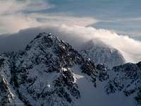 Erlspitze
Erlspitze is a mountain with three major ridges located at the south west corner of the Karwendel. Although most of Karwendel is built of limestone, Erlspitze is made of dolomite which is piled vertically. This gives the mountain a very rough appearance with lots of buttes and tooth-like rock formations. The "Zirler Klettersteig" which follows the west ridge leads through this breath taking scenery and sometimer you forget that you' re in the Karwendel.
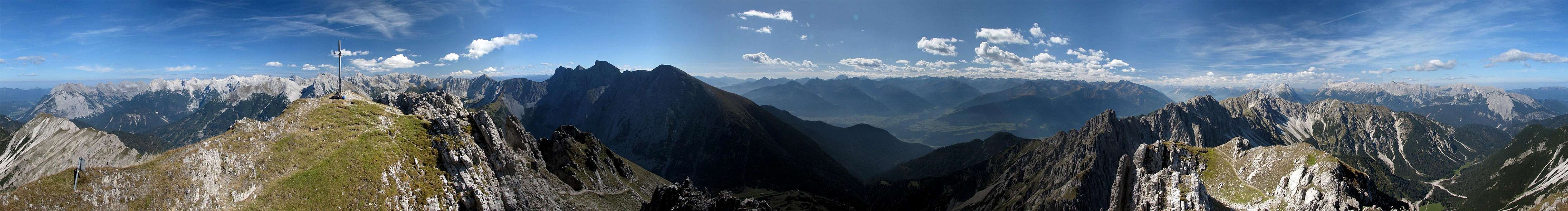
Due to its location, Erlspitze is a major viewpoint which offers a splendid panorama with a great view of the alpine main ridge, Wetterstein and Karwendel mountains. Additionally to the great views a comfortable hut called Solsteinhaus is nearby and you should enjoy a rest there.
All these pros result in lots of people ascendind it. Especially on sunny weekends during summer and autumn the summit can get quite crowded. You' re chance to experience the mountain a bit more lonely is during the week in autumn.
The first documented ascent of Erlspitze was between 1886 and 1890 by A. und F. Lieber.
Routes & Trailheads


Panoramic Views
  |
Getting There
By car
To reach the trailheads, you have to on Road 177 (or B2 in germany) which connects Innsbruck (Austria) and Garmisch-Partenkirchen (Germany). From Garmisch-Partenkirchen you have a highway connection to Munich and Innsbruck provides a conenction to Italy (Brenner). At Scharnitz you' ll have to drive to the parkinglot of the Karwendel (watch for the signs to "Karwendel Täler" close to the bridge at Scharnitz). To reach Hochzirl you have to follow the signs to "Hochzirl" at the village of Zirl. The road leading to Hochzirl passes the train station and the parking lot.By train
If you go to Erlspitze by train your trailhead is either the train station at Scharnitz or Hochzirl. Every two hours the train from Garmisch-Partenkirchen (Germany) to Innsburck (Austria) stops there. From Garmisch-Partenkirchen you have access to the trains to Munich, Ehrwald (Austria) and Rheutte (Austria). Innsbruck is the gateway to Italy (Bozen/Bolzano, Verona). For more information visit the homepage of Deutsche Bahn for german and ÖBB for austrian train connections.Camping
The area around Scharnitz (and especially Seefeld) is very touristic with several hotels and places to stay. For more information visit the multilangual homepage of the area of Seefeld. Innsbruck and Garmisch-Partenkirchen aren' t far away as well. The closest hut is Solsteinhaus on the lower slopes of Erlspitze. The hut is open from end of spring to autumn. During the winter months a winter room is available and the hut opens on sunny weekends if snow conditions are safe. | 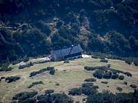 Solsteinhaus Solsteinhaus |
Mountain Conditions
Weather
- www.wetter.com
Long term forcast for Scharnitz. - ZAMG
Not as detailed as the link above, but quite accurate forecasts. - OEAV weather forecast
Weather forecast especially for mountaineering porpuses. Unfortunately this page is available in german only. - Avalanche report (Tyrol/Austria)
Current avalanche report of Tyrol. Link to the english version on the left side (pdf document).
Webcams
- http://waldhotel-seefeld.at/Webcam/webcam.html
Webcam at Seefeld looking up to Ross-hut (1751m/5745ft), about 5km from Erlspitze.
When To Climb
Erlspitze is mostly climbed in summer and autumn. During the winter months snow conditions must be very safe since the slopes are steep and very exposed to the sun.
Maps & Books
Maps
Good overview map of the hole Karwendel. For hiking porpuses this map is sufficient (scale 1:50000). The map can be bought at www.amazon.de or at KOMPASS.
More detailed map (1:25000) of the western part of Karwendel
Books
| Alpenvereinsführer - Karwendel alpin Walter Klier Bergverlag Rudolf Rother ISBN: 3-7633-1121-1 | Guide book of the hole Karwendel up to a difficulty of UIAA III. |
Red Tape
There are no permits, fees or seasonal closures.At Scharnitz there is a parking lot at the road leading into the Karwendel valleys (3 Euros per day). The other major trailhead at Hochzirl has a parking lot close to the train station, which may be free of charge but I don' t know.
Erlspitze is part of the nature reservation area Karwendel and therefore it is forbidden to camp on the mountain. Additionally you shouldn' t pick up flowers and don' t leave anything but footprints.
External Links
- www.karwendel.org
Official information page of the Karwendel nature reservation area (page in german only). - www.solsteinhaus.at
Homepage of the Solsteinhaus hut (page in german only). - www.seefeld.at
Multilangual homepage of the area around Seefeld.