
-
 6012 Hits
-
 80.49% Score
-
 12 Votes
|
|
Mountain/Rock |
|---|---|
|
|
47.22140°N / 10.33423°E |
|
|
Hiking |
|
|
Spring, Summer, Fall, Winter |
|
|
8491 ft / 2588 m |
|
|
Overview
Rotschrofenspitze is a summit in the Wetterspitze group of the Lechtal Alps.This group is situated in the western parts of the Lechtaler Alps and has some of the highest mountains of this beautiful part of the Norther Limestone Alps.
Rotschrofenspitze is one of the summits of a northwestern subgroup of Wetterspitze group, lying between Sulzeltal to the east and Kaisertal to the west, two southern side valleys of the Lechtal main valley. This subgroup consists mainly of one, south - north - running ridge which starts in the south with the rugged Aples Pleisspitzen (2632 m, 2648 m, 2655 m). To the north are following Guflespitzen (2545 m, 2577 m), Guflekopf (2563 m), Rotschrofenspitze (2588 m). At Rotschrofenspitze a subridge goes to Hahnleskopf 2210 m) above Lechtal. To the north from Rotschrofenspitze are Griestaler Spitze (2622 m) and Peischelspitze (2424 m).
 Rotschrofenspitze and (left) Falmedonjöchl; July 2007
The most important col in this subgroup is Falmedonjöchl (2272 m) for the traverse between Kaisers and Frederic Simms Hütte, a alpine club hut at the end of Sulzeltal.
Rotschrofenspitze is not the highest summit of the subgroup but the easiest one to climb. The summit is accessible via south or west ridge. It is an interesting hike from Kaisers, can be combined with summiting Griestaler Spitze or Guflekopf and can be summited while traversing from Kaisers to Frederic Simms Hütte as a highlight of such a day.
Getting There
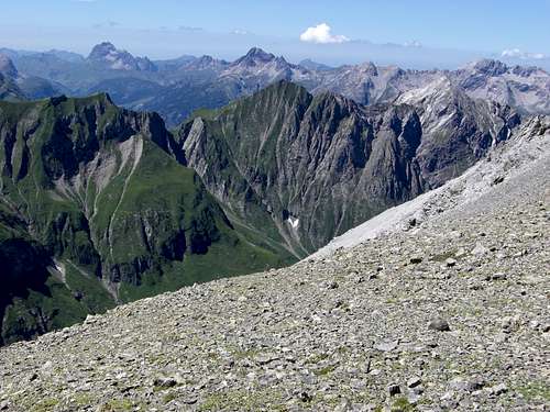
 Summit view; July 2007
You start your hike for Rotschrofenspitze from Kaisers or from the little village of Sulzelbach / Lechtal.
Road Nr. 198 from Reutte / Tirol or from Sankt Anton / Arlberg, goes through Lechtal.
Sulzelbach is located between Holzgau and Stockach.
For Kaisers leave road nr. 198 at Steeg / Hägerau in the Lechtal and follow the road up to the little mountain villages. Parking areas are near Edelweißhaus.
There is a public bus service operating in Lechtal (see schedule here). The next railroad stations are at Reutte or at Sankt Anton / Arlberg (see ÖBB schedules).
Red Tape
 Holzgauer Wetterspitze from Falmedonjöchl / Rotschrofenspitze ascent; July 2007
No restrictions or fees as far as I know.
Rotschrofenspitze is mainly a summer and autumn hike. In winter and mainly in spring Rotschrofenspitze (and some neighbouring summits) is a ski hike, too.
In summertimes only normal hiking gear and goot hiking boots are required.
For a ski hike you need full equipment and you avalanche gear.
Check the weather forecast here.
Check the avalange bulletin here.
Routes & Trails
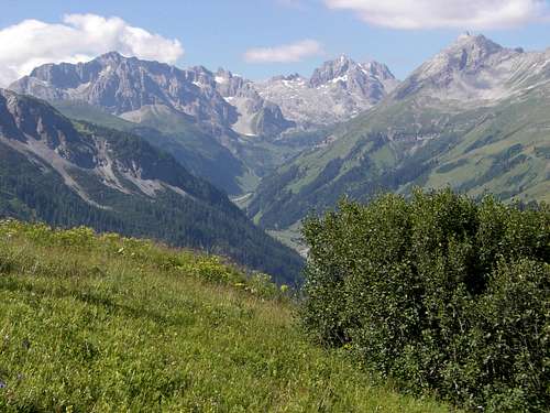
 Summit meadow; July 2007
 view from Falmedonjöchl; July 2007
Rotschrofenspitze can be summited from the west side - Edelweißhaus / Kaisers or from the east side - Frederic Simms Hütte.
West side routes
Westside routes can be easily combined to a very satisfying loop.
Falmedonjöchl and south ridge
From Kaisers / Edelweißhaus follow trail number 637 to a trail junction. Take the right trail which immediately starts zigzagging up the west slopes of Brunnegg, Lahnerwald and Lahn, where avalanche protections are installed. Pass through them and arrive the meadows of Mutte. Go straight on at another trail junction in eastern directions. The trail traverses the south slopes of the west ridge of Rotschrofenspitze and climbs steeply up to Falmedonjöchl. There you will have a great view of Holzgauer Wetterspitze.
At Falmedonjöchl turn left and start ascending on the south ridge of Rotschrofenspitze. It is a steep but easy meadow and rock ridge. You soon will arrive the summit.
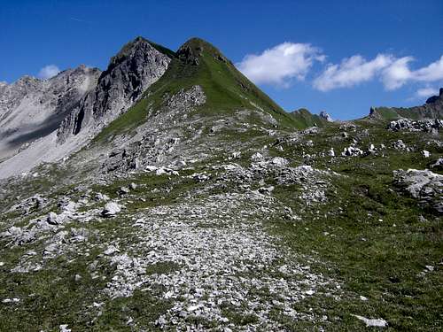
 West ridge and Hahnleskopf; July 2007
Wilder Kaiser variation
At the first trail junction on trail 637 go straight on. This trail leads up Saurenwald, crosses several creeks and arrives at Wilder Kaiser, some Alm huts high above Kaiserbachtal. The trail does a switchback there and ascends the west slopes of Hahnleskopf to the meadows of Mutte, where it reaches the above described ascent route at the second trail junction near Mutte. Follow the above described route.
 West ridge; July 2007
Hahnleskopf and west ridge
Follow trail 637 to Wilder Kaiser. Some 300 m after the trail switchback there is a trail junction. Take the left trail, crossing the fence and start ascending the steep meadows below Hahnleskopf on this small and steep trail. Those meadows are a miracle during the blossom period in june and july.
You pass by some hay storage huts and arrive at Hahnleskopf with great views into Lechtal and to Griestaler Spitze.
After Hahnleskopf the trail nearly dissapears. Follow the broad ridge between Hahnleskopf and Rotschrofenspitze. Below Rotschrofenkopf, the first belay of the west ridge, it becomes steep and more exposed. Follow the ridge on some foot tracks to Rotschrofenkopf and on to Rotschrofenspitze. The ridge is mainly steep meadows and some rocks. It might be difficult when wet and slippery.
East side route
Ascent to Frederic Simms Hütte
Trail number 636 starts at Sulzelbach. Follow the forest road into Sulzeltal. It overcomes the first steep slope on the west side of the Sulzelbach Canyon. You have to traverse a long tunnel, don´t forget a lamp (!).
Alternatively there is a trail running through the canyon and ascending steeply the west side of the canyon up to the forest road where it enters the upper Sulzelbachtal.
The road passes Sulzelalm and Ronigalm and ends at the valley station of the Frederic Simms calbleway (only supply transportation).
Use the trail zigzagging up to the visible mountain club hut, standing high above the valley at the end of the northwest arete of Holzgauer Wetterspitze.
East Route
From Frederic Simms Hütte follow trail number 637, traversing the upper end of Sulzelbachtal and the east slopes of Guflekopf and Falmedonjöchl. The trail traverses the northeast arete of Guflekopf near a belay, called Kuhköpfe, descends into the cirque below Falmedonjöchl and starts its steep ascent up to the col.
At Falmedonjöchl follow the south ridge (see above) up to the summit.
Accomodations
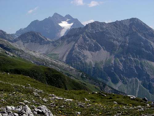
 View to Valluga, Kaisertal; July 2007
The Lechtal villages offer all kinds of accomodations.
Informations about Lechtal are available here.
The villages of
Holzgau
Hägerau
Kaisers
near the trailheads are good places to stay several days.
The following alpine club mountain huts can be used as Stützpunkt for this hike
Edelweißhaus / Kaisers
Frederic-Simms-Hütte
Kaiserjochhaus
Ansbacher Hütte
Maps & Guide Books
 July 2007
The best map is:
Alpenvereinskarte 1 : 25.000, Blatt 3/3,
Lechtaler Alpen, Parseier Spitze
Alpenverein
The best guide book for hikes in Lechtaler Alps is
Dieter Seibert
Alpenvereinsführer
Lechtaler Alpen alpin
Bergverlag Rudolf Rother, München,
ISBN 3-7633-1268-4
only available in German