
|
|
Route |
|---|---|
|
|
39.97371°N / 105.29145°W |
|
|
Trad Climbing |
|
|
Spring, Summer, Fall, Winter |
|
|
Half a day |
|
|
5.6 (YDS) |
|
|
2 |
|
|
I |
|
|
Overview
From Boulder, Dinosaur Mountain looks like a Stegosaur. The plates on the back of the beast--which paleontologists call osteoderms--are made up by the rocks in the third of the four main strata that crop out to form the mountain. From south (tail) to north (skull) one finds Stonehenge, Fee, Fi, Fo, Fum, Dum, and Dreadnaught. Though the summit of Dinosaur Mountain belongs to the fourth and westernmost stratum, from many angles it is the rocks of the third that one sees silhouetted against the sky--their smooth east faces beckoning to the climber.Quadratic Equation contours the east face of Fo, rising from the left edge of the face to the summit, which is close to the cleft separating Fo from Fum. It is a seldom-repeated route, presumably because of the relatively long approach. The rock is consequently a bit dirty, especially in the first pitch, but the position is excellent and crowding is not an issue. The first ascent was by Gerry Roach in 1987.
Getting There
From the NCAR parking lot, follow the Walter Orr Roberts trail to the intersection with the Mesa Trail, continue past the intersection on the popular Mallory Cave Trail.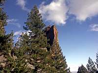 The Finger Flatiron
Route Description
With a 70 m rope, Quadratic Equation can be climbed in two pitches. The first pitch, slightly more difficult, takes one from the base of the rock to the ridge atop the shoulder. On the ridge
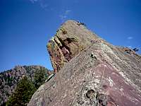 Second pitch
Descent
From the summit of Fo, Rossiter recommends to downclimb to the west until a ramp is met that heads north. The ramp takes one down to the saddle between Fo and Fum. This descent plan is certainly feasible; on the other hand, it is rather exciting and involves a few low-class 5 moves. Alternatively, sling a block immediately west of the summit and rappel down to the saddle. Each of us tried one option, and we agreed that rappel should be the more straightforward one. The Box
From the saddle between Fo and Fum, a gully descends to the east to the corridor between the third and second strata. The initial stretch of this gully looks invitingly easy, but apparently it cliffs out further down. Descending to the west takes one to the gap between the third and fourth strata. This involves a little scrambling. Turn right (north) and follow the base of the west face of Fum to the gap between Fum and Dum. Cross to the east and follow the trail that steeply descends from the summit of Dinosaur Mountain. A short scrambling section takes you to The Box, where you close the loop.