|
|
Route |
|---|---|
|
|
45.83270°N / 6.86430°E |
|
|
Mountaineering |
|
|
Summer |
|
|
A long day |
|
|
D |
|
|
III |
|
|
Overview
First ascent: Lt. Flaminio Francisci with the Sergeant Leone Savoye and the Lance Corporal Francesco Salluard, 22th June, 1940Second ascent (with variations): Lt. Gianni Bonardi with the Corporals Vittorio Comuni, Giacomo Maddalin and the Alpine soldier Enrico Belfrond, 9th August, 1940
At the beginning of 1940, because an expectation for a possible opening of the hostilities on Western front, Captain Giuseppe Inaudi, one among the promoter officers of Scuola Militare Centrale di Alpinismo, took charge of a small special unit consisting of 150 soldiers: the “Reparto Autonomo Monte Bianco”. At the central core, composed by “Alpieri” (alpine soldiers particularly drilled for fighting in mountain environment) is joined quite all the group of Courmayeur’s mountain guides and aspirant guides and some members of Italian Academic Alpine Club (a.k.a. Club Alpino Accademico Italiano); may be the excellence available for the assigned task: to garrison the massif of Mont Blanc from Col (Pass) de la Seigne to Col Ferret, about 20 Km of territory with medium altitude over 3000 meters.
For logistical purpose the massif’s front was divided into three under sectors: the “Miage” with operative headquarter at Rifugio (Hut) Gonella; the “Gigante” quartedered at “old” Rifugio Torino, and the “Ferret” with its headquarter in Lavachey; their commanders are all reserve officers (so not professional), academic members of CAAI and very famous in the climbing universe of the period: Lt. Giusto Gervasutti, Lt. Renato Chabod and Lt. Emanuele Andreis.
Up to the first day of June there wasn’t remarkable episodes: the French generals drawed up “Mer de Glace” company of battalion Chasseurs d’Haute Montagne with some patrols of specialized alpine troops quite similar to Italian “Alpieri”, known as SES (Sections Eclaireurs-Skieurs). It was quite usual that Italian and French alpine soldiers meet each other on the main border ridges without enmity: the idea was to observe the respective ranks waiting for the future events.
When Italy declared war on 10th June 1940, the battalion “Duca degli Abruzzi” composed by the permanent staff of Scuola Militare Centrale di Alpinismo was mobilized with the 5th Alpine Regiment and acquired his position to Col de la Seigne; the weather was very bad, nevertheless the late season the snow continued to fall. The “Alpieri” of “Reparto Monte Bianco” was waiting on their positions.
The situation came to a head on June, 21st when the Italian High Command ordered the offensive against France on the whole front of Western Alps. The soldiers of “Duca degli Abruzzi” are stopped into Vallée des Glaciers from the artillery of Fort de Séloge after spent few days before on hard fight, the officiers of “Miage” was afraid by a possible surprise attack from French patrols through the Mont Blanc’s summit, a zone guarded with difficulty where was possible to concentrate easily a little unit using Grand Mulets or better Vallot Hut on Bosses Ridge as outposts.
So, it was studied a project to forestall French moves: try to reach as soon as possible the Mont Blanc’s summit directly from Rifugio Gonella avoiding the normal Route and particularly the zone closer to Vallot Hut where it was very easy to be localised and exposed to adverse fire.
For this mission, planned for 22nd, was chosen two mountain guides of Courmayeur: Savoye and Salluard (both military instructors and experienced connoisseurs of the places) to support an officer during the ascent. Nevertheless the adverse weather, the weapon’s weight and the very bad conditions of the mountain the party reached his goal after 8 hours of tiring climb: but no track of the enemy! What’s a pity for the Fascist’s War Propaganda that the clouds was very thick and nobody in Chamonix hadn’t seen the Italian soldiers on the “Europe’s top”….
However there’s no time to have a rest and the day after was organized a new mission of reconnaissance near Col du Miage; unluckily an avalanche sweeped away a squad: the alpine soldier Alessandro Berthod died under the snow: it will be the only war victim of “Reparto Autonomo Monte Bianco” and to his memory was dedicated the new route opened the day before from his colleagues.
This route, the only ascent documented as mission of war on the Western Alps, was quite considered in the military environment of the epoch. That’s the enthusiastic introduction to the topo published on “Notiziario Alpino”, official magazine of Italian Inspectorate for Alpine Troops:
“The story of that new, risky route, opened on the highest summit of the massif across its South West flank by Lt. Francisci Flaminio, Sgt. Savoye Leone and Corporal Salluard Francesco all of “Reparto Valligiani Monte Bianco” will become unforgettable particularly for 2 circumstances:
1)It was climbed on June, 22nd, 1940 during the Italian offensive. In other words, it was a war mission to assert more always the undisputed dominion of the high mountain typical of Italian alpine soldier.
2)The unquestioned fact that this is the most direct route between Rifugio Gonella and Mont Blanc.
This ascent was performed with bad weather conditions.”
Getting There
The best ways to arrive in Courmayeur are well described on SummitPost's main page of Mont Blanc.Huts
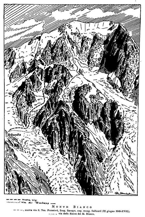
New Rifugio Francesco Gonella al Dome (m 3071), recently rebuilted and opened from Summer 2011; guarded from end June to mid September (+39 0165 885101)Route Description
The first part of this line may be useful as an alternative approach to the other classical routes on the South West face (Eperon de la Tournette, Domenech-Jaccoux route and Central Spur), because you can start from Rifugio Gonella instead of Quintino Sella Hut not too easy, very long and a bit dangerous to join, particularly during these last years.On the other hand it has the advantage to be climbed also late in then season because for long sections follows steps on good rock with sequences of medium difficulty (up to III+/IV-; the first party hasn’t used any belay screw).
The difference in level is about 1800 meters.
From Rifugio Gonella (m 3071) come down to Dome’s Glacier and cross it about 200 meters above the approach used to reach Capanna Quintino Sella from Gonella (Y couloir). Get over directly the seracs enclosed by the lowest offshoots of Rochers du Mont Blanc (or better use the rocks to the left), then continue on the following glacier up to the bergschrund. Climb a snowy runnel, not too steep, that ends on a little saddle between the summits altitude 3856 and 3878 (Italian TCI map).
Continue on slight descent across the upper section of Mont Blanc’s Glacier towards the bottom of an evident pillar on the left of a couloir closed by an overhanging serac (this pillar is near to the triangular face at the left end of the large South West slope of Mont Blanc).
Climb 200 meters of steps with slabs (difficult for the verglas during the FA), then turn right on a spur up to the bottom of two couloirs that join together like a funnel. Continue on the left couloir (found in very bad conditions during the FA, so quite difficult) and then follow the rock ridge that skirts the glacier that comes down to the “Bosses” and reach a sort of mixed spur that ends at “Tournette” (m 4677). Join the “Bosses” ridge and finally the summit (7,30-8 hours).
Descent: you can choose, according to the actual conditions of weather and mountain, one of the normal routes on Mont Blanc: the Italian, the Gouter route or the "3 Summits" route that lets you to reach Refuge des Cosmiques and the cableway of Aiguille du Midi.
Essential Gear
1 rope x 60 m, helmet, 2-3 ice screws, a complete set of nuts, ice-axe and crampons.Because we are on the Mont Blanc at very high altitude, are strongly recommended as "survival kit": map, kompass, altimeter (or electronical GPS), a thermal blanket (like the one used for caving) and a little camp stove (gas or solid fuel).
External Links
Rifugio Gonella WebsiteSocietà delle guide di Courmayeur (Mountain guides of Courmayeur)
Meteo Regione Valle Aosta
Miscellanea
The “Reparto Autonomo Monte Bianco” will survive only few months after the end of hostilities and the armistice with France (25th, June 1940); luckily it was enough time to open other interesting routes, one among them still very appreciated from the climbers: the East ridge of Pyramide du Tacul.The alpine soldiers of “Miage” sector continued their mountain drilling activity up to the end of August 1940, even an officer, Lt. Gianni Bonardi, joined as leading three times on 10 days the “Europe’s top”: on 6th, August by a partial new route on the South West flank of “Bosses”; on 9th, August repeated the “Alessandro Berthod” direct for two third ending on “Eperon de la Tournette” and finally the 15th, August climbed the classical Brouillard ridge from Col Emile Rey taking 16 hours from Capanna Sella to Rifugio Gonella!