
-
 18263 Hits
-
 88.6% Score
-
 27 Votes
|
|
Route |
|---|---|
|
|
45.82770°N / 6.86849°E |
|
|
Mountaineering, Ice Climbing, Big Wall, Mixed |
|
|
Summer |
|
|
A long day |
|
|
Alpine D+, UIAA IV+ |
|
|
Overview
Via Major on Brenva Wall
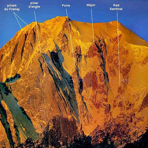
The Brenva ice wall, located on the Eastern side of Monte Bianco, is a majestic face, showing Himalayan characteristics, on which there are three main buttresses, separated by steep couloirs and huge seracs. This high and impressive wall counts some of the most fine and prestigious routes of the Alps, all long and demanding. On Brenva they were written some of the most important pages of the classic mountaineering. Taking name from the glacier that today covers with debris the entrance of Val Veni, it's a wall not to be taken lightly, facing East as told, therefore exposed to serac collapses and falling rocks. All the routes need a night starting, to be out of the wall before the sunrise. This classic route dating 1928 belongs to the famous Brenva triptych: Major, Poire (The Pear) and Sentinella Rossa (Red Sentry) routes. It’s a historical challenging route running between Sentinella Rossa on the right and Poire on the left; although not the easiest amongst the triptych, it’s the finest route and the most frequently climbed and moreover the less exposed to the objective dangers. Anyone who watches the Brenva cannot help thinking of this pronounced outcrop as the most logical route of the wall; a mixed “course”, involving also a few difficult rocky moves and showing only one dangerous point, the cross of the great ice-gully – “le Grand Couloir” - taking the origin from the summit of Monte Bianco and coming down between Major spur and Sentinella Rossa.
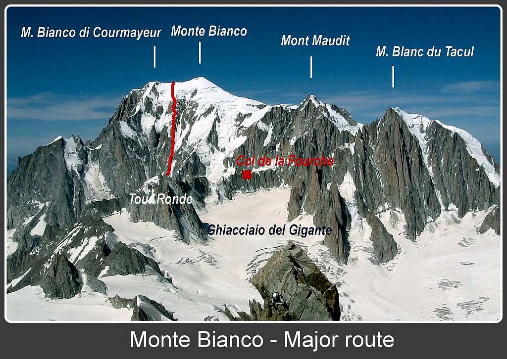
Very experienced and quick parties can climb the route starting directly from Rifugio Torino, but it’s not a good choice, being the approach itself to the route from Rifugio Torino to the Col Moore a demanding ascent. The best solution is surely to overnight at Bivacco Alberico e Borgna on Col de la Fourche, both for a safer climb and a good acclimatization.
First ascents
Brenva wall
A bit of history...
On 1865, July 14th, Edward Whymper conquered the Matterhorn; in the same moments, a hundred kilometers away, a group of British climbers was going to the foot of Mont Blanc from Entreves lead to Brenva glacier. They were A.W. Moore, G.S. Mathews, F. and H. Walker, accompanied by the legendary swiss alpine guides Jakob and Melchior Andregg from Grimsel, with two carriers. This team climbed the Brenva Spur in first ascent. Many years later the British again were protagonists on this wall, that time it was an "unguided" party to take the lion's share. The Brenva triptych was indeed pioneered by the Scottish alpinist T. Graham Brown, who first climbed the Sentinella Rossa in the year 1927 and the Major in 1928 with Francis Sidney Smythe, better known as Frank Smythe. On 1933 Graham Brown he completed the triptych climbing the Poire with the guides Alexander Graven and Alfred Aufdenblatten.
Getting there
The starting point is Courmayeur, on the Italian side of Monte Bianco, close to the entrance of Tunnel of Monte Bianco.
Road access to Courmayeur
- From Turin and Milan: follow the A5-E25 Motorway and exit Courmayeur, reaching the hamlet of La Palud m. 1370. Parking area.
- From Chamonix (French side of Monte Bianco): through the Tunnel of Monte Bianco
- From Switzerland: through the Great St. Bernardo Tunnel or the Great St.Bernardo Col or via Argentière, Chamonix and the Tunnel of Monte Bianco.
- Getting to Rifugio Torino
From Entrèves - La Palud take the cable-car rising directly to Rifugio Torino m. 3375 (exit the second station, the first one is the middle Pavillion du M. Fréty station m. 2174, the third one is Punta Helbronner m. 3470).
Approach to Col de la Fourche

|

|
Difficulty: Alpine AD-, UIAA III, 50-55°, mixed climb
Difference in level: m. 250 from Rif. Torino, 3 hours
Quite a mountaineering approach
From Rifugio Torino m. 3375, or from the upper station of Punta Helbronner m. 3470 if coming directly from Courmayeur without spend the overnigh at Rif. Torino, cross the Col des Flambeaux m. 3407, turn to left and go down on the Glacier du Géant, heading towards the North side of Aiguille des Toules m. 3300, then rising towards West to skirt the North face of Tour Ronde on the steep slopes of Glacier du Géant; gain the base of the steep ice slopes coming down from Col de la Fourche. Cross the bergschrund and climb the very steep mixed slope (150 m. high, anchors in place), getting the summit ridge and the bivouac. In case of retreat , the descent is done by 3 or 4 raps along the rocks North to the ice-slope.
Route description

|

|
Major route
Summit altitude: m. 4810
Difficulty: Alpine D+, UIAA IV+, 57°, mixed climb
Climbing length: difference in level 1328 m. from Col Moore to the summit
Time required: 8-12 hours from Col de la Fourche
Exposure: East
First ascent: T. Graham Brown and Francis Sidney Smythe 1928, august 6th-7th
Huts: Rifugio Torino m. 3375, Bivacco Alberico e Borgna m. 3684
Starting point: Courmayeur m. 1224
The route is a superb and demanding mixed climb on the wild and majestic Brenva wall. The only point exposed to the objective dangers is the crossing of the great ice-gully – “le Grand Couloir” - coming down from the summit ice-cap.
Approach to the route
- From Bivacco Alberico e Borgna al Col de La Fourche m. 3684 downclimb 80 meters on the SW gully, or the rocks on the right of the gully, toward the upper basin of the Brenva Glacier. Cross the icy basin toward S, climb the bergschrund (often difficult), reaching the Col Moore m. 3525, an airy snow-notch on the bottom of the Brenva Spur (1 hour from the bivouac).

|

|
Major route report

From Col Moore skirt toward left (facing in) the bottom of the Brenva Spur, cross three snow-gullies, then climb directly to a reddish rocky tower, the Sentinella Rossa (Red Sentry). Slant to left pass over the Mummery rib and traverse toward “le Grand Couloir”, the great snow gully coming down from the summit ice-cap of Monte Bianco. Cross the gully as soon as possible (40 m.) to reach the mixed spur on the left (facing in) of the gully, then climb directly on the spur. At first up on rocky ground, then on the first snow-ridge (the shortest one of the three). Climb a slab, traverse left and climb some chimneys, leading to the second snow-ridge at about 4120 m. Up the second snow-ridge, longer and more thin. Rocky ground leads to the third snow-ridge, the longest. Climb it, ending beneath the skirting of the great upper rocky wall. Two chimneys and some easy slabs lead to a steep snowy strip and to the upper rocky wall . From here there are three different possibilities to climb. The best way is traverse toward right to a corner, climb a hard crack inside the corner (IV+), then traverse right entering a snow gully. Follow it toward a small rocky niche. Pass the niche (IV), then climb 10 m. a long chimney-gully and exit it toward right, getting a snow-slope. Up the snow slope, ending on the summit of the upper rocky wall at about 4480 m. Climb the serac wall, then follow the upper snow-slopes leading directly to the Col Major m. 4725, on the summit ridge between Monte Bianco di Courmayeur and Monte Bianco. Follow the ridge towards right to the summit of Monte Bianco.
Descent
Descent - It's possible to choose amongst the four normal routes:
- the Dôme du Goûter route (Bosses Ridge) PD Dôme du Goûter Normal route
This route is the shortest way to descent from Monte Bianco; another advantage is, only in case of emergency, the Vallot shelter along the itinerary. This descent involves a return to the starting point (Courmayeur) by road from Les Houches to Chamonix, then through the tunnel of Monte Bianco.
- the Grands Mulets route PD- Grands Mulets Normal route
- the 3 Mont Blancs route PD+ 3 Mont Blancs route
It's the most difficult route amongst the Normal ones, crossing Mont Maudit and Mont Blanc du Tacul, nevertheless gives the advantage of going down on Valleè Blanche near the Cosmique Hut, from where it's possible to get the starting point (Rifugio Torino or Punta Helbronner) by walking through the Giant Glacier.
- the Italian Normal route PD/PD+ Italian Normal Route
Quite a long descent and not the easier, nevertheless gives the advantage of going down on the starting side (Val Veny, Italian side)

|

|
Red Tape
No particulary restrictions
Huts and Bivouacs

- Rifugio Torino m. 3375
- Bivacco Alberico e Borgna al Col de la Fourche aka Bivacco della Fourche, m. 3684 - Property C.A.A.I. (Club Alpino Accademico Italiano), 10 beds, always open
The bivouac lies on Col de la Fourche, on the border ridge running between France and Italy, separating the Géant Basin from the Brenva Basin. An eagle’s nest, allowing the access to one of the wildest and secluded place of Monte Bianco massif, the magnificent Brenva basin. It had been built in the year 1935 in memory of Corrado Alberico and Luigi Borgna, entirely re-built in 1985 and improved later on in 2008.
Gear
Rope, helmet, ice-crampons, 2 technical ice-axes, ice-screws, 5-6 quickdraws, a set of friends, some pegs
When to climb
The best period goes from July to September
Meteo
Meteo Regione Valle d'Aosta
Meteo Chamonix
Useful information
Rifugio Torino
Courmayeur Mont Blanc
Società delle Guide di Courmayeur
Guidebooks and maps
Guidebooks
“Monte Bianco Vol. I” di Gino Buscaini, Collana Guide dei Monti d’Italia CAI TCI, 1994.
“Monte Bianco - Guide Vallot” ed. Mediterranee, 1999.
“Il massiccio del Monte Bianco – Le 100 più belle ascensioni” by Gaston Rébuffat, Zanichelli Edizioni,
“Rifugi e Bivacchi delle Alpi Occidentali” by Cesare Re, Ed. Guide Macchione, 2005
“Rifugi e Bivacchi del CAI” by Franco Bo, Ed. Priuli e Verlucca, 2002
Maps
CNS 1:50000, Courmayeur, foglio 292
Kompass 1:50000Monte Bianco, foglio 85
De Agostini 1:50000, Monte Bianco