
|
|
Route |
|---|---|
|
|
45.83270°N / 6.86430°E |
|
|
Mountaineering |
|
|
Summer |
|
|
A few days |
|
|
5.7 (YDS) |
|
|
D+, 5.7, 60+ degree snow/ice |
|
|
Overview
The Innominata Ridge on Mont Blanc is a tour-de-force of mountaineering. The ascent offers glaciers, technical rock climbing, knife-edged snow ridges, a grand final snow/ice face, and not insignificant objective hazard during the prolonged traverse of the Great Couloir. Even when climbed from the relatively high Lampugnani Bivouac (aka the Eccles Bivy), this is likely to require at least one demanding day of movement in constantly steep alpine terrain to get to the summit and down to relative safety. Like all the south side routes, all the elevation must be gained on foot from 1500 meters in the Val Veni to the summit at 4800 meters. Betraying my American bias, that's almost 11,000 feet!
Climbers whose technical abilities may be up to the task can still feel like they are on an audacious undertaking, because of the commitment, the objective hazard, and the steep walls and famous routes all around. In other words, the climb has "atmosphere."
  |
Unfortunately this climb has considerable objective hazard, as rocks, snow and ice can fall down the Great Couloir seemingly at any time. It would be wise to avoid hot days and cross the couloir as close to dawn as possible. But darkness can impair routefinding in the hours of climbing required before reaching that point. A Swiss guide and client were killed on July 31, 2009 in the Great Couloir. Per UKClimbing.com, they "have fallen while crossing the Great Couloir on the Innominata ridge. The hour was very prudent (5:30am) and the altitude 4400m, but still snow conditions seem to be the cause of the accident."
On our ascent we were climbing the ridge above the Col Eccles but below the crossing of the couloir, and there was a massive avalanche that would have killed anyone in there. Entering this place is, unfortunately, rolling dice.
Another significant hazard is the danger of being caught in bad weather. Each person should have a bivy sack and sleeping bag, but a storm on exposed slopes can kill you despite this equipment. An event of great sadness to everyone here at Summitpost.org was when Rahel Maria Liu was killed in exactly that situation on this route in 2004. Luckily, her partner was able to find a bit more shelter and survive, but she was unable to move or be moved from an exposed position where extreme cold took her life.
Please respect Rahel's memory by only climbing this route armed with the best possible forecast of high pressure without thunderstorm activity for several days. Don't try to fit into a very narrow window between storms. Have the patience to wait a long time, possibly for years, until such a window becomes available.
In our case, we definitely had the good forecast, so we went for it. But it was hot in the valley, and probably, it was unwise to climb the Great Couloir. Still, if I have to befriend one devil, I'd rather it be the Couloir than the weather, which would be unrelenting in its attempt to kill you if caught in the tedious, exposed and delicate situation on the long slopes above the Great Couloir.
More overview images
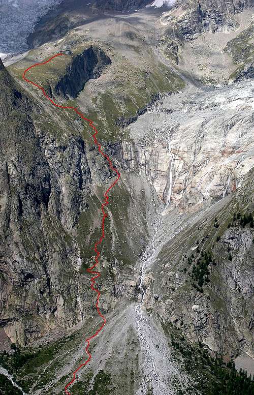
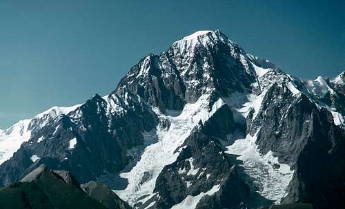 The south side of Mont Blanc with the route in red. Photo by om.
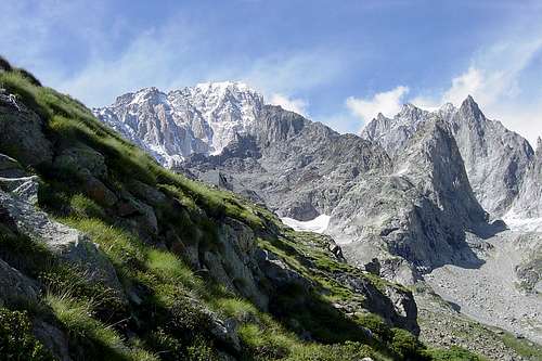
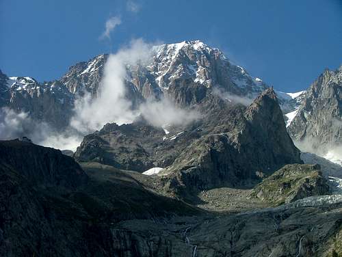 The Monzino Hut is barely visible on the left, and the route generally makes its way up the face right of the column of cloud. Photo by Nikman.
Getting There
From Courmayer, you can take a shuttle bus into Val Veni and get out at the Bar Pramotton to begin the hike. Depending on time available, fitness and length of a good weather window you may want to stay for a night at the Monzino Hut. The hut is open from June 15th to Sept. 15th, and the telephone number is +39 165 809553. There is also a winter room.
From the Bar Pramotton cross the river and follow a signposted trail that climbs moraine then more steeply (equipped with cables, some 3rd/4th class (UIAA II)) over slabs below the Glacier de Freney. The trail eventually reaches the ridgetop terminated by the Aiguille du Chatelet and the Monzino Hut. Expect to take at least 2 hours for the 1000 meters of elevation gain.
Until a flood in 1999, the hut was supplied by a lift, and it was possible to have your pack carried up for a small fee. This would certainly make it easier to decide to bypass the hut and spend the first night at the Lampugnani Bivouac!
 Final slopes to the Monzino Hut. Photo from Hiltrud
From Chamonix
It's popular to climb from the south and descend to the north, possibly from the Aiguille du Midi station back to Chamonix. For this reason it's good to know that from Chamonix a regular bus runs through the tunnel to Courmayeur (2009 cost: 12 euros per person one way). The bus takes about 45 minutes. Ask the bus driver to tell you where to access the shuttle bus to Val Veni, which costs about 3 euros.
The Lampugnani Bivouac
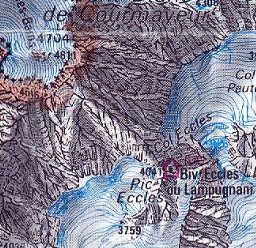
Note: The position of the Lampugnani Bivouac huts (aka the Eccles Bivy huts) is quite WRONG on the French map. See this thread at ukclimbing.com for more information. In general it is lower on the ridge to Pic Eccles than described. Also, the elevation point of 4041 meters refers to the height of Pic Eccles, not that of the bivy huts.
From the Monzino Hut, your first goal is to reach the Eccles Bivy. You can either climb the Brouillard Glacier or follow the ridge over Punta Innominata. The latter would be very aesthetic and is called the "Innominata Integrale," because it stays on the ridge the whole time. However the Brouillard Glacier is faster and probably easier as long as the glacier is in passable condition. Inquire at the Monzino Hut to see if people are still going that way.
Via the Brouillard Glacier
Walk north on a trail from the Monzino Hut. The trail becomes faint as it enters moraine below the Glacier du Chatelet. Veer leftward below cliffs to reach the access point to the Brouillard Glacier, gained on its eastern side at about 3000 meters elevation.
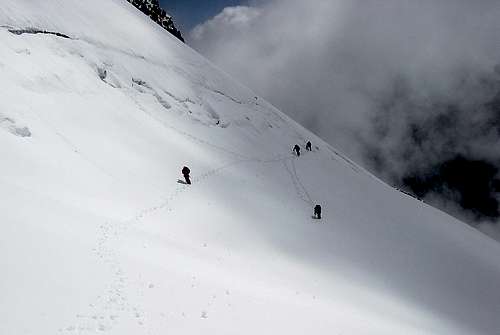
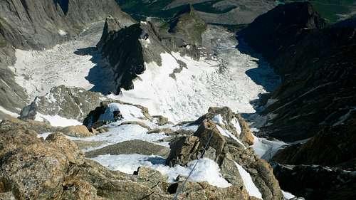
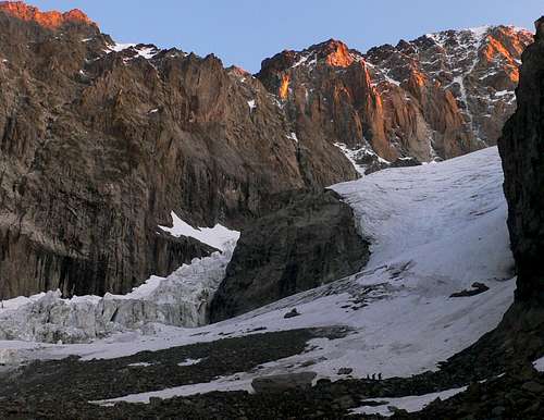 The climbers at the bottom of the picture mark the access point to the Brouillard Glacier.
 On the Brouillard Glacier
Rope up and continue easily up the right side of the glacier, passing through a short section of rock with moats and crevasses around 3400 meters. Higher, you need to gain the Col du Freney (3680 meters). A direct ascent is steep, and usually blocked by a bergschrund. Below the col, work right on glacier slopes until the 'schrund can be bypassed by steep (often icy) slopes. Some climbers may wish to belay at this point with ice screws. Now veer back left above the 'schrund to gain the col via continued steep slopes. This section can be dangerous because the climbing is icy and parties tend to get caught in here at the same time. A slip by one party could pull someone else off. Therefore, be wary of climbing below other roped, unbelayed parties!
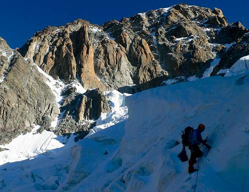
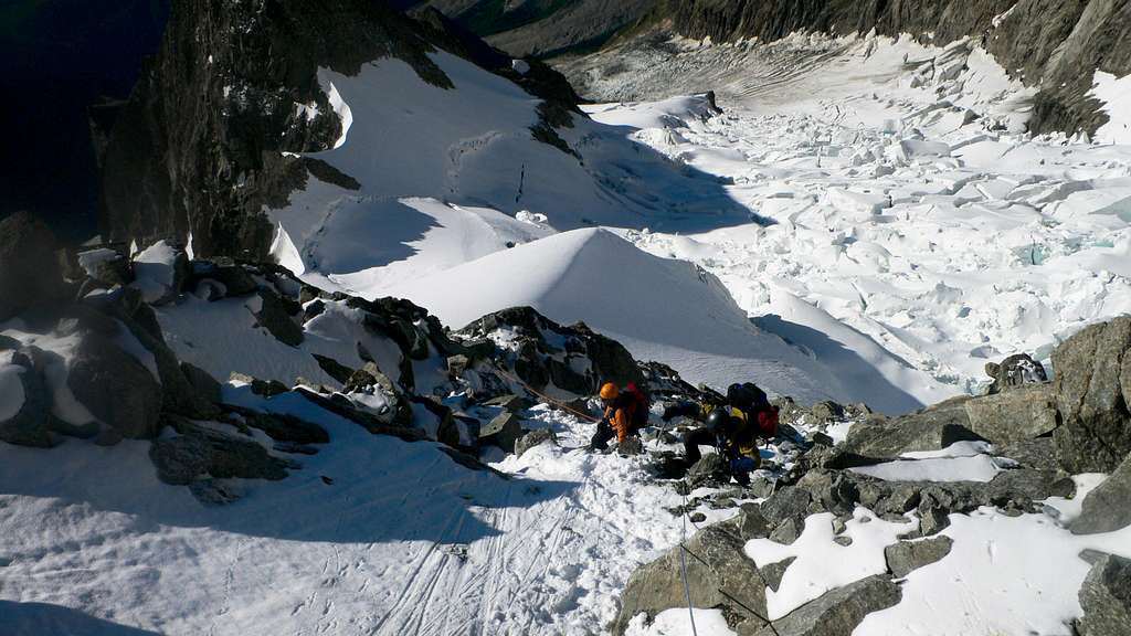
 On the Brouillard Glacier. The climbers are going up to the Col du Freney, avoiding the bergschrund via a rightward traverse.
Via Punta Innominata
I haven't gone this way so the description is a bit vague.
Above the Monzino Hut the idea is to gain the small Glacier du Chatelet and climb to the Col de l'Innominata (3205 m). Follow the ridge up to the Punta Innominata (3729 m), and then gain the Col du Freney, where the two routes meet up again.
From the Col du Freney, traverse the glacier more easily north around a buttress, then continue partway up moderately steep glacier slopes below the rock of the Pic Eccles. The Eccles Bivy becomes visble above. Leave the glacier for mixed rock and snow on a wide buttress, climbing up and left to reach the lower bivy hut. The upper one is a few minutes higher, directly visible.
 |
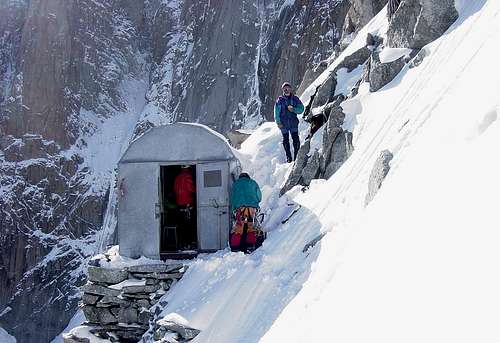 |
The Lampugnani Bivouac (aka Eccles Bivouac) huts have beds and blankets, but can be overcrowded in the summer. The warden at the Monzino Hut usually has an idea of how many people plan to stay there, and may recommend an early start in order to win a place. Contrary to our expectations, there is nowhere flat to sleep outside of these two huts. With a bivy sack and some chopping you might find a place nearby but it would be uncomfortable at best. In a storm, these huts would be a life-saver. In a good weather window, don't expect solitude at the hut, and try to nap during the day if possible, because some people will be up around 2 am getting ready to climb. The huts serve a variety of routes, from difficult rock climbs on the pillars across the Brouillard Glacier, to the Brouillard and Peuterey Ridges and the Pillars of Freney, as well as the Innominata Ridge. Venturing outside without crampons can be risky. I'd be surprised if no one fell and got hurt over the years! (The photo on the left is from Hiltrud) |
Route Description
The Col Eccles
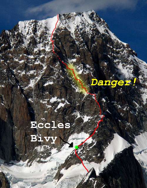
The Innominata "Ridge." Note that the upper ridge proper is avoided by the traverse of the Great Couloir.
First gain the Pic Eccles, which can take 1.5-2.5 hours from the huts, over grade II-III terrain with a few harder sections. Follow your nose and occasional cairns up the ridge. From near the summit it's possible to make one rappel on the west side of the ridge to reach ledges that traverse north to then gain the North Ridge of the Pic Eccles. Continue down this ridge with another rappel to descend to the Col Eccles.

Rappelling to the Col Eccles
Here, pause to examine the Great Couloir and try to decide if you want to continue. Returning to the bivy huts from beyond this point becomes difficult.
It's also possible to ascend the upper Brouillard Glacier to reach Col Eccles, although our attempt to go this way from the lower bivy hut had to be given up because it was steep, icy and likely more time consuming than going over the summit of Pic Eccles. Without more knowledge about it, I won't describe that variation here. Please let me know if you have more details to share.
The technical ridge
From the Col Eccles, scramble up moderate rock and snow slopes and make for a wide chimney that leads up between two towers. You need to be slightly on the left side of the crest throughout. Belay at the base of the chimney. Climb it directly (UIAA grade IV, about 5.6 YDS), finding reasonable nut protection. Leave the chimney for a crack on the right wall at a ledge. The crack is 5 meters high and ends on a belay ledge in the notch between the two towers, and the difficulty is variously rated as IV+ or V, depending on the guidebook. Our party found it quite stout! Especially factoring in the heavy pack, the altitude, and the awkward, offwidth moves. A tattered sling is tied to a nest of pitons partway that can be used as aid if needed. Belay from slings/pitons at the notch (25 meters).
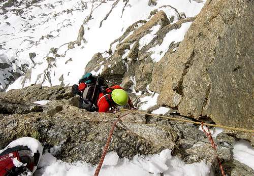 The athletic 5.7 wide crack at the end of the first pitch. Photo from Hiltrud
For the second technical pitch of the buttress, traverse an icy or slabby ramp on the right side of the crest from the belay, then climb into a hidden notch putting you right back on the crest. (20 meters, grade III+).
Third, climb awkwardly out of the notch under a huge chockstone and up an icy gully (crampons useful). From a ledge on the crest, continue up a shallow gully with good nut protection. Belay somewhere in the gully (grade IV, 25 meters to an easier angle).
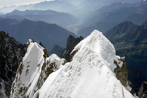
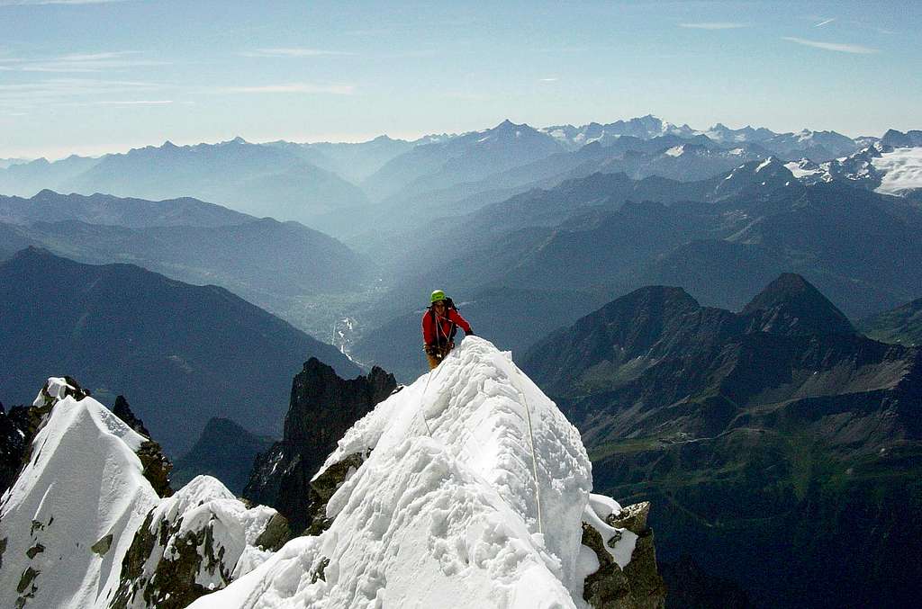
Fourth, continue up the gully as the angle eases, then continue on moderate terrain on the left side of the crest up to a striking horizontal ridge crest. This place is famous is photos as an exciting snow ridge for walking, however on our climb (early August, 2009) we found an extremely narrow and hollowed-out snow ridge. We belayed three short but time-consuming pitches which required kicking steps on the left side of the ridge.
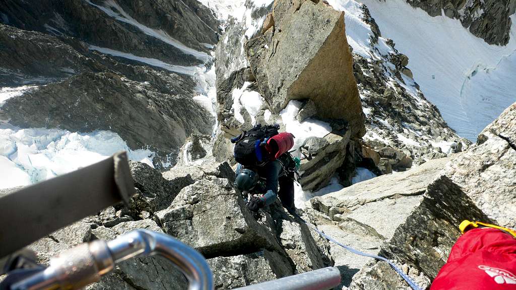 |
Now, the goal is to reach the elevation 4250 meters close on the left side of an imposing tower in order to traverse the Great Couloir. Climb reasonable mixed rock and snow, staying well on the right side of the Great Couloir. Use overhangs of rock strategically if you need to stop. Just below the target elevation, you might want to belay a pitch or two in an icy gully. A belayer can find (some) protection in this gully from debris above while the leader exits the top of the gully, continues on ice, then turns left at the narrowest part of the Great Couloir, reaching a belay after 50 meters on a rock ledge. You may need to cross an awkward waterfall or delicate ice over it. Difficulty: moderately steep snow/ice, grade III rock, 50 meters.
Left side of the Great Couloir
"A wider couloir led dangerously up into a zone that screamed stonefall at us from every angle. We were far too long in there, living on nerves already frayed by the majesty and scale of the place. If you have an ego that needs crushing, go there and see yourself as you really are. My arrogance at presuming to be there in the first place surprised me time and time again."
(quote from jcolton's excellent trip report)
Climb the red rocky buttress straight up for about 80 meters when it fades back into a snowy face, moving together or belaying as the situation requires. At that point, traverse left again (about 25 meters) to a noticeably gray rock buttress. Climb this buttress easily on shattered but blocky rock for about 100 meters. The buttress leads naturally into a gully that exits the Great Couloir on the left (belay piton and slings on a wall here, 20 meters under a strikingly overhanging rock that puts the upper gully in shadow. Climb 70 degree ice with occasional rocks to the top of the gully (45 meters).
Gaining the Brouillard Ridge
"This section seemed a long way and we were tiring now. The angle did not let up and we never noticed the sky changing texture for a while. A slip would have entailed a long fall putting more strain onto the belay and belayer than both were capable of withstanding...Cloud was blowing around and it became quite cold. The angle had not eased and the strain was quite telling and I wished the ridge would arrive."
(quote from jcolton's excellent trip report)
Now comes a long (and possibly somewhat punishing) climb up snow and ice with occasional rock outcrops. From the belay at the top of the exit gully described above, go up and a bit left to gain a shallow ridge that barely emerges from the face. If it's late in the afternoon, this snow will have gotten a lot of sun and can be treacherous. Another horizontal snow ridge with a bit of descent follows. Continue up the rock outcrops of the ridge until it fades into snow/ice of the great face above. Climb snow and ice to reach the Brouillard Ridge. It's possible to see people walking on this ridge from very low in this section, which is interesting. It's especially interesting to discover how long it can take to join them up there!
Escaping the Great Couloir for slabby/snowy ridge and face.
In this section two tools can be most helpful. This section is also terribly exposed to bad weather. There may be more shelter on the right side of the ridge in case of fierce wind. A retreat from this point is difficult to contemplate, though some thought to being able to reverse the route even at this high point should be taken. Although this section is technically straightforward, and gaining the Brouillard Ridge represents a great easing of difficulty, there is no protection from the kind of storms Mont Blanc could through at you. Just to keep in mind...
The final leg
Follow the Brouillard Ridge right in occasional ups and downs on short roping (moving together) terrain toward the summit of Mont Blanc du Courmayeur. It's not necessary to visit that summit, rather, a bit below the summit, you can veer leftward on easier slopes to continue to the true summit of Mont Blanc. This is only worthwhile if you have good visibility and, preferably, a traversing trail already in the snow. Climb broad slopes easily to the summit of Mont Blanc.
Descent
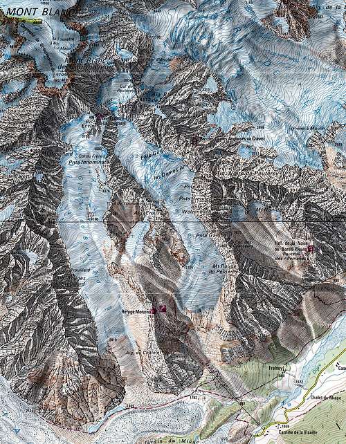
Map section with the route
Descend one of the normal routes on Mont Blanc, for example the Gouter Route or the "3 summits" route to the Aiguille du Midi. Note: on the "3 summits" route, you don't have to climb over the Mount Maudit and the Mont Blanc du Tacul to reach the Aiguille du Midi. For both peaks, there should be a wide track on a bypass, though the bypass for Mount Maudit is quite steep (rappel anchors and a fixed line may be in place to descend approximately 140 meters of 50 degree snow).
Essential Gear
Detail of the main route
- All the equipment for glacier travel, including 3-4 ice screws and at least a 50 meter 8.5mm rope.
- Additional protection: nuts, a few cams, a few pitons
- A second ice tool with a hammer would be helpful, even if you just take one for the party.
- Bivy equipment: pad, sleeping bag, bivy sack.
- A stove and fuel
External Links
Here is a brief report on Rahel and Edward's accident.
An excellent video of the climb gives a good idea of what to expect. However, at the 3/4 length in the video for about 2 minutes these guys climb an extensive section of rock. I'm really not sure where they are, it must be a variation.
Here is a nice slideshow of the climb.
Here is another video from the climb, this one with very good quality from August, 2011.