
-
 6483 Hits
-
 79.04% Score
-
 10 Votes
|
|
Route |
|---|---|
|
|
50.86535°N / 115.65001°W |
|
|
Mountaineering |
|
|
One to two days |
|
|
Class 4 |
|
|
II |
|
|
Commentary on South West Face of Mount Assiniboine and Lunette Peak Massif
The overview, getting there and essential gear sections provide some great preparatory information for an ascent of the South West Face of Lunette Peak. I wanted to qualify my route description for the South-West Face of Lunette Peak by clearing stating we only descended this route, so I think our perspective is not complete to provide a comprehensive account of an ascent of the route. On our trip, after spending the night at the R.C. Hind Hut, we solo’ed the North Ridge of Mt. Assiniboine with no wind, little snow or ice and dry rock. I found our descent down the SW Face of Assiniboine horrid. The near vertical cliffs are comprised of some of the worst rock I have encountered in the Canadian Rockies.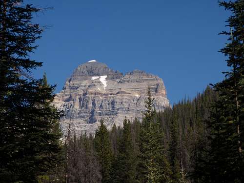
From the Assiniboine/Lunette Col to the summit of Lunette Peak, and down to tree line, the rock quality is still very poor, but not as steep and loose as above the col. I wouldn’t recommend ascending the SW Face of Mt. Assiniboine, but would recommend a traverse of Assiniboine to Lunette Peak for avid peak baggers. In my opinion, the photograph with the route marked in Bill Corbett’s book (see reference below) is the best description. The SW Face is vast and complex, but in dry conditions, it is a Class 4 scramble to the summit of Lunette Peak.
Overview
Lunette Peak is an obscure outlier on the South Ridge of Mount Assiniboine. Although only really a bump on the South Ridge, it is an officially designated separate peak and on the list of Canadian Rockies 11,000 foot summits. Lunette Peak has a summit elevation of 3400 metres (11,155 feet). The prominence from the Mt. Assiniboine/Lunette Peak col to the summit of Lunette Peak is only 40 metres (130 feet) with an approximately isolation between the summits of Assiniboine and Lunette of 600 metres (1970 feet).Getting There
Since Lunette Peak is essentially the south summit of Mt. Assiniboine, the approach is the same as Assiniboine. If only ascending Lunette Peak, the approach via Assiniboine Creek is the only realistic approach. If combining a climb of Mt. Assiniboine and Lunette Peak (highly recommended) either the Lake Magog or the Assiniboine Creek approach is viable. Mt. Assiniboine/Lunette Peak is located on the continental divide, so partly in Alberta (Banff National Park) and British Columbia (Mount Assiniboine Provincial Park). The standard and most used approach for Mt. Assiniboine is from the shores of Lake Magog, and for less energetic parties, via helicopter to the Assiniboine Lodge helipad.Assiniboine Creek Approach
 |
|
Dow’s description for the approach up Assiniboine Creek provides excellent information for both the drive to the parking area near Aurora Creek and the hike to the R.C. Hind Hut. If traversing Mt. Assiniboine to Lunette Peak, a night stay at the R.C. Hind Hut is recommended. Hike to the hut from the Aurora Creek parking area takes 5 to 6 hours and is approximately 11 km. If only ascending Lunette Peak, at the obvious and cairned Y intersection, about 4.5 kilometres from the parking area, turn right (east) to follow Lunette Creek to Lunette Lake. Once at Lunette Lake, continue North East towards the South Slopes of Lunette Peak. Great bivy locations at tree line with lots of water available, approximately GR943345.
|
|
|---|
Magog Lake approach
 |
|
If traversing Mt. Assiniboine enroute to Lunette Peak; the Magog Lake approach can be used. Shortest hike to Magog Lake is via Bryant Creek to Assiniboine Pass, from the parking lot along the Smith-Dorrien Road in Spray Valley Provincial Park (75 km south of Canmore) the hike is 25 km to Magog Lake. Parties with less pride, time or too much money can helicopter to Assiniboine Lodge. Once at the lake, follow a trail along the west side taking a right fork beyond the end of lake that leads to a left raising scree traverse. Follow the scree trail, well right of the main gully (usually full of snow) to a series of well cairned ledges that head left towards the main gully. Just before the top of the gully, head straight up the slope and soon to the hut.
|
|
|---|
 |
|
If only climbing Lunette Peak, likely you would not want to approach from Magog Lake. One can climb Lunette Peak without ascending Mt. Assiniboine, from the R.C. Hind Hut, via the Mt. Sturdee/Mt. Assiniboine Col, but the approach from Lunette Lake is much shorter and does not require glacier travel. This approach, from Magog Lake, to Lunette Peak, and Mt. Assiniboine, via Sturdee Col, was used by the first ascent party in 1901.
|
|
|---|
Red Tape / Camping Bivouacs
Mt. Assiniboine/Lunette Peak is located on the continental divide, so partly in Alberta (Banff National Park) and British Columbia (Mount Assiniboine Provincial Park). No permit is required to park or climb in either park. Bivying in Mount Assiniboine Provincial Park, above Lunette Lake, does not require a pass or fee. Camping in designated backcountry campgrounds and cabins in Mount Assiniboine Provincial Park does require prepayment. See link for more information.Mount Assiniboine Provincial Park
Reservations for the R.C. Hind Hut must be made through the Assiniboine Lodge.
Assiniboine Lodge
Route Description
- South West Face, Alpine II
 |
|
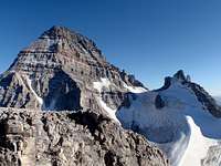
Upper section (usually termed West Face) was the line of the first ascent in September 1901. From bivy site above Lunette Lake, round the low cliff band on the right (south) and head to a long gully, usually snow until late August. Climb the gully or loose right hand edge. At the top of the gully continue up easy terrain, when the angle lessens onto a plateau, here, head left across the plateau about halfway up, turn upwards to ascend small steps to a basin (can be wet). Then upwards over easy rock and snow towards a prominent and large orange face. The lower section below the orange face has many cairns, some with paint and flagging. There were several lines marked, all were Class 3 or easy Class 4. At the orange face, head right to the end of the orange wall, up, then traverse left to gain terrain above the orange block.
|
|
|---|
 |
|
From top of orange block head leftwards towards the minor Assiniboine/Lunette Col. Easy terrain, need to traverse left to see gully as you near the summit cliff bands. On our ascent there were no cairns or obvious signs of travel above the orange face. Nearing the col, climb snow/ice gully to col (would be hard snow or ice), or ascend easy rock ledges to right of gully. Just below the col, climb steep Class 4 rock on edge of snow and main gully to gain horizontal ledges right of col. Once on easy scree ledges, traverse right to gain rock bands below summit. A variety of lines are possible, but climbing should be easy (Class 4) and usually not require a rope. We gained the horizontal ledges just below the col (about 10 metres) and had to attempt several lines to finally access the summit block. In the end our line was turned out to be basically below the summit, but hard to see this from below. Final summit block is solid, but difficult Class 4. Descend the same way.
|
|
|---|

|
 |
 |
 |
|---|
Essential Gear
If the South-West Face is dry and snow free, then only a helmet is required. The SW Face is vast and complex, but in dry conditions, it is a Class 4 scramble to the summit of Lunette Peak. If there is snow and ice, then crampons, axe or even a rope (and protection) may be required. Most years will have snow and ice lingering into August or September. Early season climbs will likely require the additional gear, more time and roped climbing. The rock is loose, but protection from pitons would be possible. We did see several rappel anchors on our descent, below the orange band, but these sections are possible to downclimb (Class 4).If approaching via Sturdee Glacier, then bring standard glacier travel and crevasse rescue gear; depending on snow coverage, pickets or ice screws, pulleys, locking carabiners and carabiners, slings and prussiks. Probe is useful for detecting crevasses.
We had summit temperatures of 20 C (70 F) in late September, but this is not the norm. High quality clothes are required. Rain/snow storm shell, down jacket, waterproof climbing boots and good food.
Reference
Bill Corbett’s book, The 11,000ers of the Canadian Rockies, provides a comprehensive climber’s guide and history to the 54 11,000-foot peaks in the Canadian Rockies.11,000'ers of the Canadian Rockies