-
 9640 Hits
-
 79.04% Score
-
 10 Votes
|
|
Mountain/Rock |
|---|---|
|
|
45.29492°N / 109.82448°W |
|
|
Hiking, Mountaineering, Scrambling, Skiing |
|
|
Spring, Summer, Fall, Winter |
|
|
11817 ft / 3602 m |
|
|
Overview
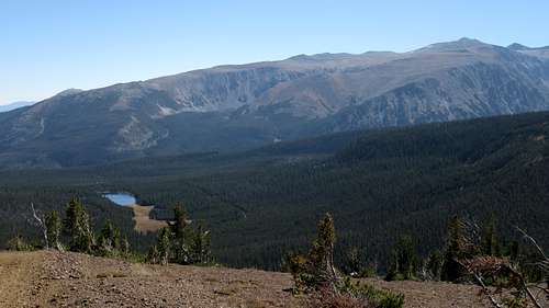
This peak is merely the high point of the massive Stillwater Plateau which encompasses a large part of the northern Beartooth Range. Reaching it involves little more than class 1 hiking, but it is an important peak to note due to its proximity to the approach to the north side routes on Mount Wood, and Pyramid Peak. Climbers wishing to ascend nearby Mount Wood from the north will likely hike over this peak which offers fantastic views in every direction. Many of the peaks in the Western Beartooths (aka Montana Absarokas) can be seen from this perch as well as the expansive Yellowstone River Valley to the north.

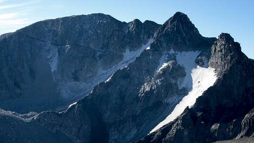
Mount Wood From Stillwater Plateau
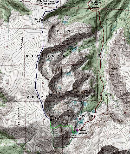
Getting There
The Benbow Mine (aka Golf Course) trailhead is the normal starting point for people hiking this peak. This trailhead is unmarked and difficult to get to. A tough passenger car can make to the Benbow Mine but a high clearance 4WD vehicle is advised, and certainly required if you plan to drive beyond Benbow Mine. Note that in the "Hiking the Absaroka-Beartooth Wilderness" Falcon Guide book, this trailhead is called the Lake Wilderness trailhead. Information about getting here can be found on page 97 of this book.
In short, if coming from Red Lodge, start from the MT 308 and US 212 junction at the south end of town and drive north on US 212 for 1.5 miles and turn left onto MT 78. Continue on this road west for 30 miles and turn left on CO Road 419 (also called Nye Road) and continue on this road for 14 miles passing through the small town of Fishtail on the way. Just past the Montana Jacks Bar and Grill in the tiny town of Dean, turn left (south) onto Benbow Road (FS 1414). Drive this very windy road as it switchbacks up to the Benbow Mine head frame after 11.4 miles at an elevation of 8,480 feet. Park passenger cars here. 4WD vehicles can continue driving up a series of switchbacks, which were likely used when the mine was active, for an additional 2 miles to a large open meadow land known as the Golf Course (apparently some miner thought it looked like a golf course). The road continues down a short ways to the trailhead at the south end of the meadow at an elevation of 9,100 feet. A sign marks the end of the road.
 Chrome Lake | 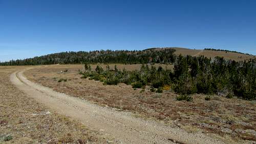 Golf Course Trailhead | 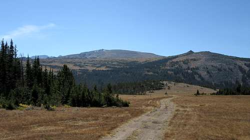 Road across the Golf Course |
Route
From the trailhead, begin hiking south on the nice trail as it descends for a few minutes and crosses a broad saddle between the head of two creeks; Little Rocky Creek to the east and Flume Creek to the west. Past this, the trail weaves through an open forest and reaches meadows around 9,500 feet. The trail then makes a series of long switchbacks up the meadow, and reaches a SW-NE ridge at 9,900 feet where views to the south open up showing an unnamed lake in a small basin below. The trail continues in a SW direction along the top of the ridge to a flat area at the top of a large permanent snowfield at 10,060 feet. Two large cairns mark the end of the constructed trail a few minutes beyond this spot. It's 2 miles from the end of the 4WD road to the end of the trail, and the trail is in great condition when not snow covered.
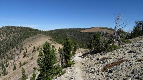 Saddle between Flume and Little Rocky Creeks | 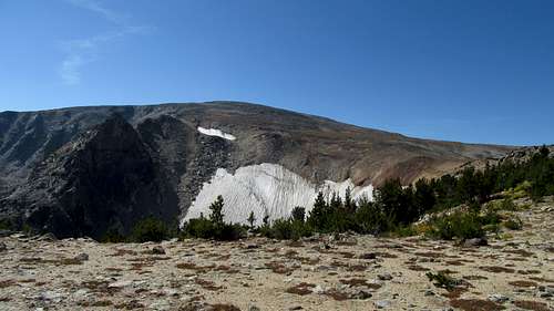 Looking up the Stillwater Plateau | 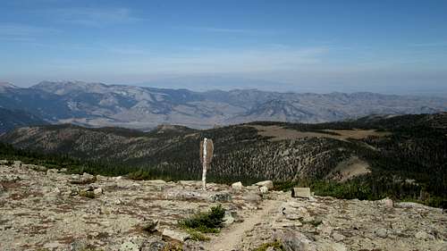 Wilderness boundary on the Stillwater Plateau |
From the end of the trail, continue south for an additional 2.7 miles along the plateau to the 11,340 foot saddle just north of the Stillwater Plateau HP (Point 11,817).The best way to cross the plateau is to hike over Point 10,819, and contour west around Point 11,649 at around the 11,300 foot contour. The talus on the plateau can be quite large in spots so plan for a tedious hike. Once at the 11,340 foot saddle, continue hiking SE another 0.3 miles to the summit. The total one way distance from the end of the 4WD road to the summit is 5 miles, and will take even the most seasoned hikers at least a few hours to reach the summit due to all the boulder hopping. Views of Mount Wood just across the West Fishtail Valley to the north are intimidating.
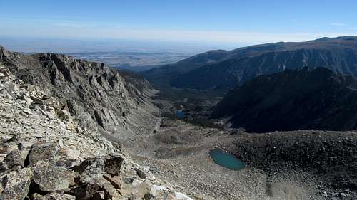 Unnamed lakes to the east of the Stillwater Plateau | 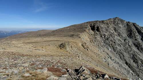 Point 11,649 | 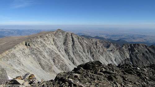 Point 11,649 from Stillwater Plateau HP |
Camping/Red Tape
Camping can be found anywhere near the Benbow Mine or along the Jeep roads on the golf course meadow. If continuing on towards Mount Wood, great camping can be found at the uppermost West Fishtail Lake. There is no red tape to speak of for this peak, or the surrounding area, however it lies within the Absaroka-Beartooth Wilderness therefore no motorized vehicles, bikes, or airplanes are allowed beyond the end of the 4WD road. Practice leave no trace hiking.
Mount Wood from Stillwater Plateau HP
When to Climb
Summer climbing season is short in Montana. Late July through early September are the months that are most snow-free. However, expect some snow on the mountain any time of the year. Expect any type of weather any time of the year. Violent thunderstorms are a common daily occurance. Get an early start to avoid afternoon thunderstorms. Storms develop very fast and tend to come from the south or west. This is especially important for this peak since you are above treeline, and on a wide open plateau nearly the entire hike. DO NOT attempt this peak when storms are in the forecast, unless you are planning a 4am start! Even then, you should plan to be on your way down no later than 10am or so.