
-
 22740 Hits
-
 88.91% Score
-
 28 Votes
|
|
Mountain/Rock |
|---|---|
|
|
45.16100°N / 109.772°W |
|
|
Hiking, Mountaineering |
|
|
Spring, Summer, Fall |
|
|
12409 ft / 3782 m |
|
|
Overview
Mount Peal is a seldom climbed peak located in the Beartooth Mountains of South-Central Montana. It is one of Montana's 27 ranked peaks that rise over 12,000 feet. This peak is located just to the Southeast of Tempest Mountain, which most people either pass around or hike over on their way to Granite Peak. Mount Peal provides fantastic views of both Tempest and Granite Peak and provides a real remote alpine adventure through the pristine Turgulse Lake Basin. Most parties will take three days to climb Mount Peal, setting up a camp in either the Arch Creek or Phantom Creek drainage.Mount Peal is connected to another named, 12er called Mount Pleasant. Dedicated peak baggers will want to stroll up Mount Pleasant after reaching the summit of Mount Peal. Mount Pleasant is just to the southeast, and has a prominance of 169 feet. Also note that the USGS incorrectly lists the elevation of Mount Peal as 12415 feet.
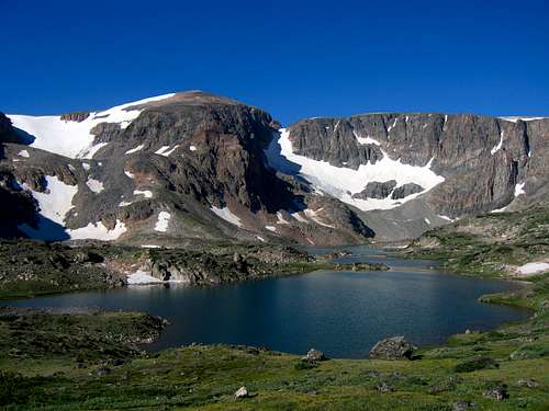 Mount Peal and Froze to Death Lake | 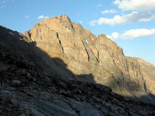 The rarely seen west face of Mount Peal | 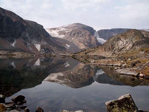 Mount Peal reflection |
Getting There
Most parties will climb this peak using the Phantom Creek Trail or the East Rosebud Trail, both of which originate near Alpine, Montana which is a small resort town situated around East Rosebud Lake.
Phantom Creek Trailhead
From the MT 308/US 212 junction in Red Lodge, go north on US Highway 212 for 1.5 miles to the junction with MT 78 and turn left (west). Continue on this road 20 miles to the small town of Roscoe. Drive through the tiny town which is home to the Grizzly Bar and Grill (great food). Turn left on the East Rosebud Road and measure from this point. At 2.6 miles the road turns to dirt. Cross East Rosebud Creek at mile 3.7 on a nice bridge and immediately past the bridge turn right to stay on East Rosebud Road and cross a cattle guard. At mile 8.3 enter the Custer National Forest where the road becomes paved once again and it turns into FS 2177. Pass by the Jimmy Joe Campground at mile 10.3 and continue to mile 11.9 here the road becomes dirt again. At mile 13.6, turn right at the Phantom Creek Trailhead pullout and park. There is room for about 8 cars and sits at an elevation of 6,200 feet.
Approach
From the trailhead, begin hiking up the trail as it switchbacks up through a burn area with views of East Rosebud Lake, and the town of Alpine below. The trail mellows out after the initial ascent into the narrow Phantom Creek Valley and reaches Slough Lake after 2.5 miles at an elevation of 7,520 feet. Continue up the trail as it steadily climbs above the north side of the valley and reach the first rightward switchback two miles from Slough Lake at an elevation of 8,400 feet. There is a large cairn at this switchback marking the path to Phantom Lake. Leave the main trail and continue southwest along this decent trail as it traverses through trees initially, passing below a small waterfall on a few logs, and then emerging onto a large talus slope 0.3 miles from the main trail at 8,600 feet. Continue following the best path up the talus and as you gain elevation, try to stay on the left edge of the talus slope to avoid the worst of the scree and loose boulders. It's a 600 foot ascent up this talus slope at which point you will reach a small saddle to the right (north) of the large waterfall draining Phantom Lake at 9,330 feet. Locate the path and follow it another half mile from the saddle through a narrow grassy valley to Phantom Lake.
RT Distance from Trailhead to Phantom Lake: 11 miles
 Slough Lake on the Phantom Creek trail |  Phantom Lake |
East Slopes Standard Route - Class 2 & Moderate Snow
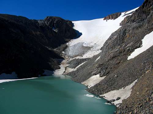
From camp at the north end of Phantom Lake, hike around the right (west) side of the lake, reaching the inlet stream after 0.3 mile. Cross it on some logs and rocks which may require wading in early season. Pass by a couple more camp spots around some trees and continue on a boot path through a narrow canyon and to a flat meadow. Avoid the thick willows to the left side of the stream and reach a nice waterfall coming down from steep rock slabs just over a mile from the north side of Phantom Lake. Cross to the west side of the waterfall and begin hiking up the smooth granite slabs staying on the right (west) side of the stream which is draining Froze to Death Lake. Continue up the slabs on easy Class 2 terrain for 0.5 mile until reaching the large Froze to Death Lake at 10,180 feet. Hike 1 mile around the right (west) side of the lake. You'll have to ascend 100 feet up to the west to avoid a cliff band that drops right into the water. Continue to, and around a small tarn, through a tiny 10,320 foot saddle just right of a 10,400 foot knob (where views of Turgulse Lake are awesome) and descend easily to the stream. Cross it right at the outlet of Turgulse Lake and continue southwest to Brent Lake at 10,200 feet. Hike around its right (west) side and begin ascending a grassy ridge to the right of a large talus slope at the head of Brent Lake. At 10,580 feet, stay right of the talus and climb up solid rock on a small rib (Class 2+) and continue up to 10,900 feet where the terrain flattens reaching an overlook of an unnamed bright green tarn. Descend 50 feet to it and hike around its right side on horrible boulders. Don't be temted to countour above it as the slopes above are just awful.
Assuming you're making the ascent in the traditional summer climbing season, the permanent snowfield will begin just across this tarn. In spring, snow will likely continue all the way down to Phantom Lake but in late season (September) the entire snowfield which usually begins around 11,000 feet may be covered in debris and likely icy, and might also have small crevasses which may require a rope team just to be safe. Come prepared. Begin ascending very mellow snow at 11,000 feet trending rightward. At 11,300 feet the snow steepens to about 40 degrees then eases slightly at 11,800 feet. Stay to the right and weave above the cliffs and reach easy snow again (20-25 degrees) at 12,000 feet. The snow ends around 12,310 feet where you can continue on easy talus for a quarter mile westward to the summit. The views of Granite Peak are spectacular and you can even see the majority of the other Beartooth 12ers.
Note that instead of curving to the right on the permanent snowfield and climbing snow all the way to 12,300+ feet, you can continue straight up the snow to the 11,800 foot saddle between Mount Peal and Mount Pleasant however there is typically a large moat and cornice right below the saddle you will have to either hike around or negotiate. The snowfield makes for a fantastic glissade just be careful to avoid the cliff section.
RT Distance from Phantom Lake - 11.5 miles
 Small tarn and the start of the snowfield | 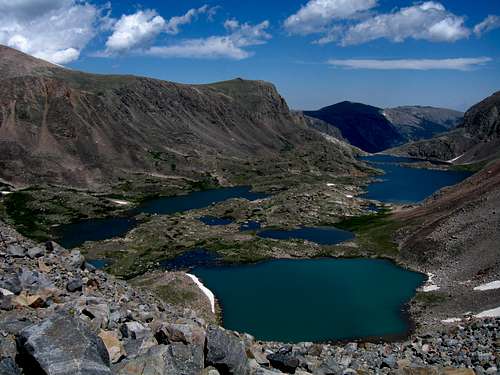 Looking down on Froze to Death Lake | 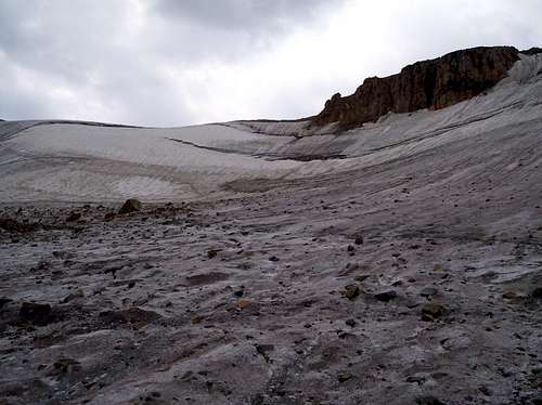 On the Peal Glacier. The route curves right of the cliffs seen here. |
Map
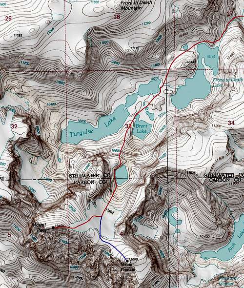
Mount Peal Route Map with the standard East Slopes route in red
Camping/Red Tape
Mount Peal and Mount Pleasant are located in the Absaroka-Beartooth Wilderness, Custer National Forest, Beartooth Ranger District. No fees are required to climb or camp. You are "requested" to check in with the Beartooth Ranger Station in Red Lodge or call (406) 446-2103 before climbing or camping in the back country (although most people do not bother). You must have a permit to cut live trees for firewood. No mechanized vehicles are allowed in wilderness areas. Excellent camping is found at Phantom Lake which sits about 500 feet below treeline offering fantastic fishing and alpine scenery. You can also camp higher at Froze-to-Death Lake above treeline.
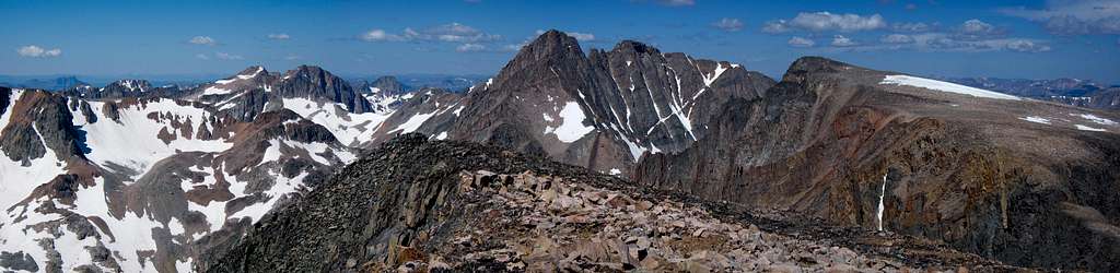
Mount Peal Summit panorama with Granite Peak in the center
When to Climb
Summer climbing season is short in Montana. July through early September are the months that are most snow-free. However, expect some snow on the mountain any time of the year. Expect any type of weather any time of the year. Violent thunderstorms are a common daily occurrence. Get an early start to avoid afternoon thunderstorms. Storms develop very fast and tend to come from the south or west. Note that this route is best climbed when the snow conditions are better usually in July. Avoiding snow entirely on this peak is very, very hard. Come prepared with crampons, ice axe, good boots and a helmet.Mount Peal can be climbed in the winter. The road up to Alpine, Montana is generally kept open year round. You are advised to contact the Beartooth Ranger Station at (406) 446-2103 for the latest conditions and road closure information.
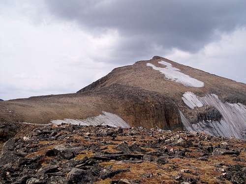
Mount Peal from the saddle in late season. Notice how the snow is very poor
Alpinist - Aug 10, 2009 11:40 am - Voted 10/10
Approach from FTD PlateauThis is for anyone who is considering an approach to Mt Peal from the FTD Plateau. There are a couple of use trails shown on some topo maps that drop from the FTD Plateau down to FTD Lake. The term "use trail" in many states means that there is an unmaintained trail of some sort that you can follow. Apparently, this is not the caes in Montana because there is absolutely no trail of any kind leading from the FTD Plateau down to the lake. In fact, if you are carrying a heavy pack this route is very dangerous and should be avoided. The route consists of steep loose scree mixed with mobile home sized boulders that must be navigated. Mt Peal looks like an attractive add-on climb following an asecnt of Granite Peak. However, I highly recommend that you do not attempt this approach carrying a heavy pack.