
|
|
Mountain/Rock |
|---|---|
|
|
56.74350°N / 5.03062°W |
|
|
Highland |
|
|
Hiking, Mountaineering, Trad Climbing, Mixed, Scrambling |
|
|
Spring, Summer, Fall, Winter |
|
|
3278 ft / 999 m |
|
|
Overview
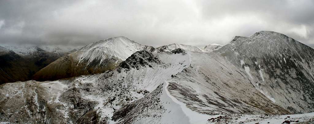
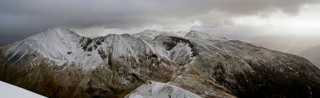
When one gazes upon the precipitous north eastern face of Stob Bàn (which literally means White Peak in Gaelic), one can be forgiven for thinking that they're not among the modest peaks of the Grampian Mountains, but are in the presence of a shapely and towering alpine behemoth, that it's slopes are home to a tribe of lederhosen clad goat herders, and that somewhere in the valley bellow a buxom, young, Aryan lady awaits your return with a krug of finest Bavarian beer and a steaming hot plate of schweinsbraten. Of course this isn't the Bavarian Alps, and all that awaits you is a deep fried Mars Bar and a bag of chips, washed down with a can of lukewarm Irn-Bru, and that's if you're lucky. Unhelpful ational stereotypes aside, there is much to recommend this mountain and, in my opinion, it deserves an ascent by anyone who visits the area for the purpose of mountaineering. Located in the western reaches of the Mamores, the mountain rises sharply out of Glen Nevis' shadowy confines, distinctly separate from its neighbours; a pyramidal beacon in an otherwise subdued locality. Reaching a height of only 999m it's not the highest of the range's mountains, however it does have the requisite elevation to qualify as both a Munro and a Marilyn meaning that it is often a target of British peak baggers. Despite its Munro status, the close proximity of the Ben Nevis Range, the eastern Mamores and, a little further to the south, Glen Coe, means that Stob Bàn is infrequently visited making it a good outing for anyone searching for a bit of solitude. The mountain is best visited in winter, after a good depth of snow has accumulated on its ridges and in its gullies. When under such conditions the mountain becomes a mountaineer's playground with a range of mid-grade winter climbs to choose from. Perhaps owing to Stob Ban's special geology, good rock climbs are relatively sparse, and during the summer an ascent is probably best made via one of the hiking routes. |

Routes
This section summarises some of the most popular routes on Stob Bàn. It is not meant as a definitive guide but as a helpful pointer on what the mountain has to offer. For a more detailed description of the various routes available I recommend the following guidebooks: Scrambles in Lochaber by Noel Williams Ben Nevis Rock and Ice Climbs by Simon Richardson HikingAllt Coire a' Mhusgain (approx 5km) The route takes the path from the Achriabhach carpark in Glen Nevis south up the Glen that runs parallel to Stob Bàn's North Ridge. The route then leaves the main path via a left hand fork at grid reference NN 152 662, which on the Ordnance Survey 1:25,000 map is just shown as a sharp bend. From here the path steeply climbs the southern flank of Stob Choire a' Mhail to a col that separates Stob Bàn in the west from Sgurr an' Iubhair in the east. From here the route follows the crest of Stob Bàn's east ridge to the summit. Via Mullach nan Coirean (approx 7km) The route starts at the Achriabhach carpark in Glen Nevis and takes the road a short distance west to a junction at a forestry track. From here it follows well signposted tracks and paths through the forest to a stile over a deer fence at a location near grid reference NN 132 680. The final section of forest is quite boggy so if your sinking knee deep into some very smelly mud then your probably going the right way. From the stile a path follows the deer fence up to the crest of a broad ridge, which it then follows to the summit of Mullach nan Coirean (which is a Munro so give yourself a tick there). From here the route is a very enjoyable ridge walk, occasionally stuttered by easy scrambling, which ends on the summit of Stob Bàn. Scrambling North Buttress photo-topo (Photo by JoeHarris) North Buttress photo-topo (Photo by JoeHarris)North Buttress (Grade 3) Only one scramble is described by Noel Williams in his guidebook Scrambles in Lochaber, so it's a good thing that it's a good one! The route starts in the upper reaches of Coire a' Mhusgain (translation - Rotting Corrie), and can be reached by following the path that heads up the glen from the carpark at Achriabhach. The route begins up an ill defined series of slabs and scree slopes until one reaches the start of the buttress proper and the start of the real scrambling. The buttress is climbed in a diagonal line, starting at the lowest rocks in the centre and ending at the rop left hand corner of the crags. The final push to the routes finish involves a steep down climb which soon leads to easier ground. Rock ClimbingRight this is going to be a short section. Owing to Stob Bàn's unique geology the mountain's rock is too broken for good rock climbing, and with the mass of easily accessible crags located just the other side of the glen at Polldubh, there really is very little to attraction in pursuing new lines. For those who are determined to technically climb the mountain in summer there are currently two options:
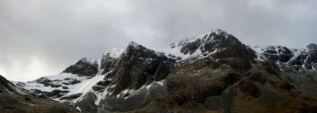
Winter climbing on the other hand, is a different matter altogether... Winter ClimbingGiven the right conditions Stob Bàn's North-East Face boasts a number of interesting mid-grade routes. Most of the routes described can be found in Simon Richardson's guidebook Ben Nevis Rock and Ice Climbs, so for full, well illustrated descriptions of the climbs go buy the book. However since the latest edition of the guidebook was published in 2002 a number of new routes have been added to the mountain. These are also listed here, and full descriptions can be found on the SMC's website - HERE.  The North Ridge (Photo by JoeHarris) The North Ridge (Photo by JoeHarris) Stob Bàn from Glen Nevis (Photo by JoeHarris) Stob Bàn from Glen Nevis (Photo by JoeHarris) Stob Bàn from the west (Photo by Nanuls) Stob Bàn from the west (Photo by Nanuls)South Buttress Ollie 45m Grade IV, 4 Eag Blanc 100m Grade II East Wing 180m Grade V, 5 South Gully 150m Grade I North Groove 160m Grade III, 4 North Ridge Route 150m Grade IV, 4 Banjo 200m IV, 4 North Gully 150m Grade I Banter 200m Grade III Central Buttress No Toddy 150m Grade III, 4 Stertor 200m Grade IV, 4 Central Gully 150m Grade IV, 4  The North Ridge (Photo by JoeHarris) The North Ridge (Photo by JoeHarris)Gendarme Ridge 150m Grade IV, 4 Triad 150m Grade III Skyline Rib 120m Grade IV, 4  The Southern Face (Photo by JoeHarris) The Southern Face (Photo by JoeHarris)Rampant 250m Grade IV, 4 Bodice Ripper 150m Grade IV, 4 Flake Chimney 150m Grade III North Buttress East Ridge 200m Grade II/III 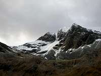 The North East Face (Photo by JoeHarris) The North East Face (Photo by JoeHarris)Overlooked Gully 150m Grade III, 4 Foxtrot 150m Grade III |
Mountain Conditions
The main drawback with climbing in Scotland is the unreliable weather conditions. Being close to the west coast, thaws are common and a certain skill is required in predicting when to make a trip. This section displays the mountain conditions for the West Highlands, of which Stob Ban is a part. Click on the widget for maps and further details. This West Highlands weather forecast is generated by the Met Office Weather Widget Some useful links for determining conditions are listed below: Abacus Mountaineering - Climbing conditions The Scottish Avalanche Information Service (SAIS) - Does exactly what it says on the tin Mountain Weather Information Servise (MWIS) - weather forecast (just in case you hadn't guessed) Metcheck - 7 day weather forecast |
When To Climb and Essential Gear
This obviously depends on whether winter or summer climbing is your thing. Winter routes on the west coast of Scotland generally come into condition in the second half of the winter. In the last three years March has been the best month however this part of Scotland is far from predictable. Despite Stob Bàn's comparitivly low altitude it can get very cold with temperatures dropping to near Arctic levels, many inexperienced walkers and climbers have been caught out in these conditions most are rescued safely by mountain rescue teams however occasionally the consequences are more serious, and every year casualties occur. During the summer it can rain a lot. Whatever time of year you need to check weather and conditions beforehand as they are erratic. In summer always wear a solid pair of boots and carry full waterproofs. In winter conditions extra layers are essential and an ice axe must be carried and if an attempt is to be made on the harder scrambles a helmet, crampons and a rope are also all essential. For true winter routes specialist winter and ice climbing equipment is necessary and owing to the unpredictable conditions of snow and ice these lines should only be attempted by those with experience of winter techniques.
|
Getting There
Stob Bàn is located towards the centre of the Mamore range in the Lochaber region of western Scotland. Most people will probably choose to climb the mountain from its northern side, and in my opinion its best side. You can gain the summit from Knlochmore (NN 186 621) by way of the West Highland Way, but I'm only going to describe how to get there from the north. Basically all you have to do is get to the car park at Achriabhach in Glen Nevis (NN 145 683) which can be reached from Fort William along the unclassified road that runs the length of the glen. Fort William is served by both bus and train services. Some information about reaching the town by public transport, as well as the public transport is available here. Trains can be booked here. If you plan to take the over-night train between Fort William and London (or on route) then make sure you have a berth reserved. As a last resort there is a seated carriage but if this is full then you won't be allowed to ride the train. Citylink operate a bus service between Glasgow and Fort William. Some of these buses also continue to the Isle of Skye. Fort William can also be reached from Oban, Kyle of Lochalsh and Inverness. One bus a day runs to Mallaig and in summer a couple also go to Kingussie and Aviemore. The town is easy to reach by car. I'm not going to list every road route here so consult Google Map or an equivalent. There is a no good or bad approach but on occasions roads close due to heavy snow fall. |
Red Tape and Access
This being Scotland, there is no red tape! |
Camping and Accommodation
Club HutsThe CIC Hut 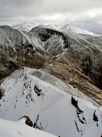 Stob Bàn's East Ridge (Photo by Nanuls) Stob Bàn's East Ridge (Photo by Nanuls) Mullach nan Coirean (Photo by Nanuls) Mullach nan Coirean (Photo by Nanuls)The hut (NN 168 722) is situated at an altitude of 680m making it the highest mountain hut in the British Isles. It's small, unmanned and books up quickly due to its perfect location beneath the north face. The hut was built in 1928 and opened on 1st April 1929. The full name of the hut is the Charles Inglis Clark Memorial Hut. Clark was a young member of the SMC who died in the First World War. As it's located on Ben Nevis, it probably isn't the best choice for anyone looking to climb Stob Bàn, but worth a mention anyway. The hut can be booked via the SMC website, however you'll have to reserve you place early as there is the beds are always in high demand: Link Alex MacIntyr Memorial Hut The Alex MacIntyr Memorial Hut (NN 044 612) is situated at North Ballachulish between Glen Coe and Fort William. The hut can accommodate sixteen people in five different bedrooms. Facilities include a well-equipped kitchen, drying room and car park. The hut is open to members of the BMC/MC of S and their families, so be aware that bookings are only accepted from clubs and individuals affiliated to either of those organisations and only one guest per member is permitted. It can be booked through the BMC website: Link. HostelsThe Glen Nevis Youth Hostel (NN 127 717) is a really convenient place to stay if you're planning to climb in the area. The hostel sits at the foot of Ben Nevis and so is in easy reach of Stob Bàn. The hostel has 88 beds, and houses everything you would need including a large kitchen/dining area, a drying room, a TV room and a small shop (which is poorly stocked in winter). If you are without a car a shuttle service runs along Glen Nevis in the summer and in the winter a one way taxi fare between the hostel and Fort William will set you back around £6 (2008). The hostel can be booked on line from the SYHA website or by phone on 08701 553 255. A complete directory of independent hostels in Scotland can be found here Fort William AccommodationAs you would expect Fort William is home to a wide range of accommodation ranging from bunkhouses to hotels. An extensive list of accommodation for Fort William is listed HERE CampingI'm not going to list all the camp-sites in the Ben Nevis area because there are lots, so a complete list of camp sites can be found HERE. Wild CampingWild camping is a fantastic way of enjoying the Sottish countryside, and in some cases will be the only convenient way of accessing a mountain or climb. However if you are planning on wild camping, do so responisbly in a way that has a minimal affect on the environment. The Scottish Outdoor Access Code provides advice and guidance on how to keep impacts to a minimum - LINK |
Maps
Guidebooks
External Links
| General Scottish Mountaineering Club - Scotland's national mountaineering club The Mountaineering Council of Scotland - Scotland's official mountaineering body British Mountaineering Council - Britain's official mountaineering body Climbers Club - British national climbing club Lochaber Mountain Rescue Team - Information about the Lochaber Mountain Rescue Team www.mrcofs.org - Mountain Rescue Committee of Scotland Scottish Ski Club - home page of the Scottish Ski Club Nevis Range - ski centre information for the Ben Nevis area Visit Scotland - website for the Scottish Tourist Board Visit Fort William - tourist information for Ben Nevis and the surrounding area Munro Magic - informtion of the Munros The Highland Council - local authority home page Scottish Natural Heritage - Scotland's statutory body for the protection of landscapes Lochaber Geopark - Geological information about Lochaber Joint Nature Conservation Committee - Britain's statutory body for the protection of wildlife Nevis Sport - a major outdoor shop and mountain centre in Fort William Mountain Conditions West Coast Mountain Guides - Avalanche information, climbing conditions and weather forecasts. Abacus Mountaineering - Climbing conditions The Scottish Avalanche Information Service (SAIS) - Avalanche information Winternet-Scotland - Scottish mountaineering conditions Weather Mountain Weather Information Servise (MWIS) - mountain weather forecast Metcheck - 7 day weather forecast Met Office - Weather from the Met Office Weather Channel UK - Weather Channel weather Travel Lochaber Transport Forum - local public transport information National Rail - UK Train Timetable Showbus - bus timetables for the UK Citylink - Scottish bus timetables Inverness Airport - home page of Inverness airport BAA Glasgow Airport - homepage of Glasgow airport Glasgow Prestwick Airport - home page of Glasgow Prestwick Airport BAA Edinburgh Airport - home page of Edinburgh Airport Caledonian MacBrayne Ferries - ferry information and timetables for the wet of Scotland ecossenet: Taxis - list of taxi companies operating in the Fort William area Accomodation Visit Scotland: Fort William - an extensive list of accomodation in and around Fort William The Mountain Bothies Association - information on bothies (mountain huts) in Scotland Scottish Youth Hostel Association - home page of the SYHA Glen Nevis Youth Hostel - page of the Glen Nevis YHA Scottish Independant Hostels - a directory of independant hostels in Scotland UK Campsite.co.uk - directory of campsites in the Fort William area Maps and Guidebooks Ordnance Survey - Britain's national mapping agency Harvey Map Services - an excellent selection of maps designed specifically for outdoor enthusiasts Cicerone Guidebooks - guidebooks for people of all abilities Climbers Club Guidebooks - guidebooks for climbers Scottish Mountaineering Club - guidebooks and publications for and about Scottish mountains |
Ken A - Nov 13, 2015 8:13 am - Hasn't voted
Updated infoHi, Under 'External Links' and 'Mountain Conditions' could you please update the URL for West Coast Mountain Guides to: http://www.westcoast-mountainguides.co.uk/category/news/ Much appreciated! Ken Applegate