
|
|
Mountain/Rock |
|---|---|
|
|
56.56979°N / 4.88282°W |
|
|
Argyllshire |
|
|
Hiking, Mountaineering, Ice Climbing, Scrambling, Skiing |
|
|
Spring, Summer, Fall, Winter |
|
|
3576 ft / 1090 m |
|
|
Overview


Stob Ghabhar is undoubtedly one of the finest peaks within the Black Mount range. This range stretches from the foot of Loch Tulla to the Kingshouse hotel in Glencoe. When driving along the A82 road between these two points, you can't help being impressed by the magnificient array of peaks situated on your left hand side. This viewpoint is emphasised to its best in the winter snow capped months.
Stob Ghabhar (pronounced Stop Gower) sits at a height of 3576ft/1090m and is listed as No.55 in the Munro tables. Its translation into English from Gaelic means Peak of the Goat.
Stob Ghabhar's pointed summit lies at the centre of a number of ridges that provide excellent walking above deep corries. The best of these ridges is the Aonach Eagach. While not as impressive as its namesake in nearby Glencoe, this short narrow crest still involves a degree of airy scrambling.
There are two main points of ascent. These both start at the Abhainn Shira, but split at the point where the rivers Allt Toaig and Allt Coire na Muic join. Both routes have excellent stalkers paths. The latter route gives a lovely viewpoint of the lochan Coirein Lochan when reaching the bealach between Stob Ghabhar and Stob a'Choire Odhair.
The views from the summit really are breathtakingly good. To the south the peaks of the Bridge of Orchy Hills sit beautifully over Loch Tulla. To the west are the peaks of the Glen Etive Hills. To the east the vast expanse of Rannoch Moor with its many lochs glisten like stars in the sunshine and to the north the remainder of the peaks of the Blackmount range roll onwards towards the peaks of Glencoe, the Mamores and Nevis Range (if you get a really clear day).
This peak offers everything from beatufil scenery to lochans and waterfalls from airy narrow ridge walks to moderate scrambling. In the winter skiing can be done around here and the neighbouring peaks of Stob a'Choire Odhair, Sron na Giubhas and Aonach Mor. The summit cairn is also perched close to the upper coloir, which has been a classic ice climb since it was first climbed in 1897.
Approx time for completion: 7 hours.
Getting There
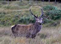
Stag near Victoria Bridge
From Glasgow take the A82 road through Crianlarich and Tyndrum until reaching Bridge of Orchy. Turn left directly after the Bridge of Orchy hotel onto the A8005 road. Follow this road for roughly 3 miles until reaching the Inveroran Hotel. Continue on until reaching the parking for the Victoria Bridge viewpoint at the foot of Loch Tulla.
Red Tape
There is no red tape in Scotland due to the Land Reform (Scotland) Act 2003 which incorporated the Scottish Outdoor Access Code. This code, which commenced on the 9th of February 2005, has established statutory rights of access to land and inland water for outdoor recreation.
The Land Reform(Scotland) Act 2003
Scottish Outdoor Access Code
The following aspects should be taken into consideration when you are in the Scottish countryside;
- Seek local advice in regard to deer stalking or grouse shooting activities
- Ensure that all gates are closed behind you
- During the lambing season (March to May) ensure that all dogs are kept on a lead
- Please refrain from feeding or annoying any animals
- Limited parking space is available at the start of many routes, please ensure that you are not blocking a road and/or entrance
- Parking is provided at the start of some routes by the local farmers, it is polite to ask if you can use this facility
- Try to refrain from crossing fields with animals and/or crops if an alternative route is available
- Ensure that you treat the local environment with care by leaving it as you found it and by taking any litter home with you
- Any camp fires should be carefully watched and only used away from dense forest areas
Accommodation
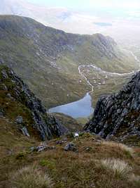
Coirein Lochan
There is the Inveroran Hotel at the foot of Loch Tulla.
There is a hotel In Bridge of Orchy www.bridgeoforchy.co.uk/
Camping can be done close by any of the above hotels.
There is also a bunkhouse www.westhighlandwaysleeper.co.uk/
Further accomodation is also available in Tyndrum which is 10 miles away. I would highly reccommend the wigwams here www.sac.ac.uk/consultancy/wigwams/
Maps and Books
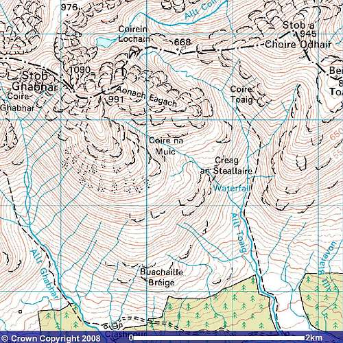
Image reproduced with kind permission of Ordnance Survey and Ordnance Survey of Northern Ireland.
Maps
Harvey superwalker map: Glencoe
Landranger map 50
OS map explorer 377
Books
The Munros book by Cameron McNeish page 57.
50 More Routes on Scottish Mountains by Ralph Storer page 24.
The Scottish Peaks by W. A. Poucher by page 159.
Mountain Conditions

Stob Ghabhar's waterfall
The weather in this area is very changeable. This can happen very quickly and you should not venture here unless you are fully equipped for all weather possibilities. If you experience a sudden deterioration in the conditions, then turn back.
Weather forecast
Avalanche forecast