|
|
Mountain/Rock |
|---|---|
|
|
33.48590°N / 82.22500°E |
|
|
Hiking, Mountaineering |
|
|
Summer, Fall |
|
|
21096 ft / 6430 m |
|
|
Overview
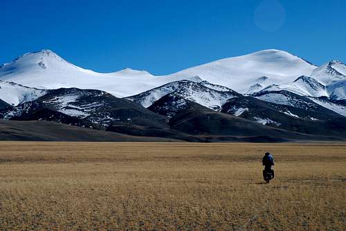
Tagchagpuri is a glacier-covered mountain located in western part of Tibet. The mountain has two prominent summits. The 6430 m high East summit is a steep glacier-covered pyramid of granite rocks, while the 6302 m high West summit is less steep and accessible through a long ridge from the North. Both summits are separated by a 6098 m high glacier-covered saddle. The Tagchagpuri glacier on the northern side extends down to about 5500 m. On the south side the glacier ends at around 6000 m, covering only the top third of the approximately 1000 m high south face.The Tagchagpuri mountain area displays a very diverse geology with schist scree in close neighborhood to granite formations, breccia rocks and metamorphic sediments. The region has signs of heavy tectonic folding, deep canyons surround the mountain.
Getting There
| Access to North side of the mountain: Start in Kashgar, Xinjiang province, China. Travel to Domar, a settlement at km marker 830 of road 219 (Yecheng-Ali road). About 10 km south-west of Domar, a newly constructed gravel road forks from road 219 in south-east direction towards Yanhu. Follow this road until a flat pass with prayer flags at 33.18367°N 81.22588°E, then find a small track leading due east. The track leads over a pass of 5202 m at 33.51419°N 82.14132°E which is located within 5 km of the north-west base of the mountain. Leave the track there and find a suitable base camp anywhere near the mountain. | ||
| Views during the ascent to East summit: | ||
Red Tape
Permit is required, inquire at Chinese Mountaineering Association.Climbing conditions
Best climbing season for Tagchagpuri is summer and fall. Then, weather is stable and snow conditions on the steep mountain are best. The summit ascent is steep and exposed. Tagchagpuri is easiest accessed from its northern side, where the glacier forms a smooth transition to the gravel hills. On the South face of Tagchagpuri, the glacier is very steep and more crevassed. From the north, Tagchagpuri can be climbed in a day trip from any base camp at the foot of the mountain.
Camping is possible anywhere, but depending on the season it can be difficult to find water unless going very close to the glacier. A deep canyon with a larger river flowing North is accessible at 33.54494°N 82.21062°E, altitude 5170 m.
At least in summer and fall, nomads live on the grass plain north of the mountain and the track leading within 5 km of the mountain is regularly frequented by small trucks.


