
-
 8553 Hits
-
 81.84% Score
-
 14 Votes
|
|
Mountain/Rock |
|---|---|
|
|
47.65836°N / 11.92085°E |
|
|
Hiking, Sport Climbing, Scrambling |
|
|
Summer, Fall |
|
|
5551 ft / 1692 m |
|
|
Overview
 Taubenstein as seen from Schinderkar in the south Taubenstein as seen from Schinderkar in the south |
High above the resort of Spitzingsee, located directly beside a cable car station, which heads up from the lake, you can find a nice piece of limestone rock: Taubenstein. Like its neighbours in the Bavarian Prealps it is embedded in beautiful meadows and forests, but it barely rises above the tree tops. Thanks to the cable car it is a very popular destination. Its easiest route is a short UIAA I scramble, heading for the summit from Taubensteinsattel across slabs. It is protected by a steel cable and a sign, warning that only experienced climbers should try the ascent, which unnecessarily deters a lot of unskilled people. The cabling makes sense for the descent in wet conditions but apart from this is outright dispensable.
 N face N face |  SW summit SW summit |  Main summit Main summit |
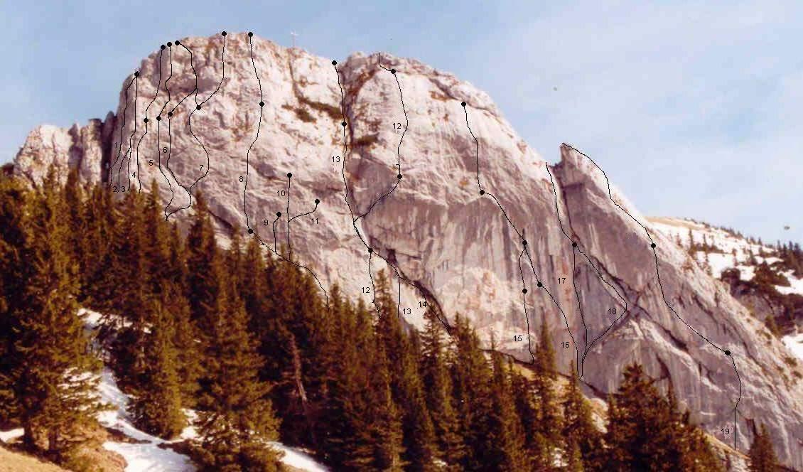
Taubenstein, however, is more than just the 15 minute scramble from the cable-car. The short access and the 100m high vertical north-west face make it an ideal location for sports climbing in the area. Taubenstein is composed of solid limestone rock and up to 25 routes have been developed on the face. The first route went up in 1935 already but during WW II nobody thought of repeating it, even less of setting up new routes. During the post-war a few routes were developed but after that, the climbing possibilities of Taubenstein were forgotten. During the heyday of alpine sports cimbing – during the eighties and nineties – quite a number of routes went up. Another decade went by without much activity before in 200e the IG Klettern München & Südbayern started to restore the classical routes and started developing new ones as well.
The initiative was started by Tom Schlager, who also did a compilation of routes which you can find in the following links. The first one is the original compilation of 2002, the second one is a pdf document with the updated set of routes, from which the route overview above has been linked.
Route difficulties are up to 9, lengths up to four pitches.
  |
Getting There
 Taubenstein seen from the south
From Munich:
- By car:
- Take motorway A8 direction Salzburg
- At the exit Weyarn switch to St2076 to Miesbach
- There swiitch to B472, then B307 south
- Drive through Hausham, Schliersee and Neuhaus until you get to the side road to Spitzingsee
- Park your car at the cable car parking lot to the north of the lake
- By train / bus (hourly service from Munich central station):
- Take the train to Fischhausen / Neuhaus just north of Spitzingsattel.
- Switch to the bus which will take you to Spitzingsee
Red Tape
 Astrantia major
 There are no restrictions in the area. However, make sure that you park your car in a free parking lot. Many of the lots in Spitzingsee are privately owned and you are either not allowed to park there or have to pay a small fee.
Accommodation
For Accommodation in the Schliersee / Spitzingsee region, follow the following link:Schliersee / Spitzingsee accommodation
Weather Conditions
Maps & Books
Maps
- Bayrischzell
Kompass Map WK008
1:35000
ISBN: 978-3-85491-352-8
- Tegernsee - Schliersee<
Topographic Map UK 2
1:25000
ISBN: 3-86038-001-X
- Mangfallgebirge
Topographic Map UK L12
1:50000
ISBN: 3-86038-484-8
Books
- Hiking
- Leichte Wanderungen in den bayerischen Voralpen
Heinrich Bauregger
J. Berg Verlag
ISBN: 978-3765840609
- Leichte Wanderungen in den bayerischen Voralpen
- Ski Touring / Snow Shoeing
- Winterwanderungen in den bayrischen Voralpen
Heinrich Bauregger
J. Berg Verlag
ISBN: 978-3765840784
- Winterwanderungen in den bayrischen Voralpen