
-
 38216 Hits
-
 95.01% Score
-
 50 Votes
|
|
Area/Range |
|---|---|
|
|
47.65000°N / 11.63249°E |
|
|
Spring, Summer, Fall, Winter |
|
|
6844 ft / 2086 m |
|
|
Overview
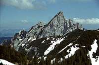
Ruchenkoepfe seen from Rotwand
The Bavarian Pre-Alps are the mountains between Rosenheim and Garmisch-Partenkirchen. They shouldn´t be mistaken for Bavarian Alps. The Bavarian Alps are all mountains that belong to Bavaria. The Bavarian Pre-Alps are a part of the Bavarian Alps like Wetterstein or Chiemgau. They are also called "Muenchner Hausberge (Home-Mountains of Munich)", because they are all shortly reachable from the metropolitan Munich within an hour. The highest peak is Krottenkopf in the western part near Garmisch-Partenkirchen. Excepting the area around Krottenkopf, no other area of the Bavarian Pre-Alps reaches the elevation of 2.000m.
This part of Bavaria is a high frequented tourist-area all year round. You can go hiking or laying at the lakes and go swimming in summer. In winter you can ski in one of the many ski-resorts (e.g. Lenggries/Brauneck) or go on one of the many ski-tours (e.g. Hirschberg). To toboggan in this area is also very popular, see the corresponding section below.
Range boundaries

Brecherspitz
The Bavarian Pre-Alps are bounded by the river INN in the East and by the river LOISACH in the West. The Bavarian Pre-Alps run out to the North to the lowlands of Munich the capital of Bavaria. The southern border of this range is quite difficult. It is not defined by a national border or a big river. It is more defined by the change in the geological structure of the mountains. South of the Bavarian Pre-Alps are ranges like Karwendel or Rofan, which are existing more of lime than the northern neighbor. The four corners of the Bavarian Pre-Alps are Munich - Rosenheim - Kiefersfelden - Garmisch-Partenkirchen.
The South-border of the Bavarian Pre-Alps (From West to East):
Garmisch-Partenkirchen - Kankerbach (river) to Kaltenbrunn - Kranzbach (river) to Kruen - Isar (river) to Vorderriss and Sylvensteinspeicher (lake) - Walchen (river) to Achenwald - Achenbach (river) towards Achenkirch - Ampelsbach (river) to Guffert-hut - Sattelbach (river) to Erzherzog-Johann-Klause - Brandenberger Ache (river) southwards to Kaiserhaus - Ellbach (river) to Riedenberg - Glemmbach (river) through Glemmbachklamm to Ascherdorf - Thierseer Ache / Klausbach (river) to Kiefersfelden.
Subareas and mountains
- 1. Wendelstein-Area
- 2. Grosser Traithen-Area
- 3. Schliersee-Spitzingsee-Area
- 4. Hinteres Sonnenwendjoch-Area
- 5. South of Tegernsee
- 6. Blauberge & Schinder
- 7. South of Bad Tölz, Benediktenwand-Area
- 8. Herzogstand-Area
- 9. Krottenkopf-Area (Estergebirge)

Getting There

Kloster Benediktbeuern
The four corners of the Bavarian Pre-Alps are Munich - Rosenheim - Kiefersfelden - Garmisch-Partenkirchen. The "Getting There" section oughts to show the way to the four big cities around the Bavarian-Pre-Alps.
Munich:
Munich is the capitol of Bavaria and third biggest city of Germany. It is popular for its Oktoberfest and Wheat-beer all over the world. The biggest section of the German Alpine Club (Deutscher Alpenverein) is also located there.
- You reach Munich from North (Nuernberg) via highway A9 in 90 minutes.
- From East (Stuttgart) via highway A8 in 2 hours.
- From West (Salzburg) via highway A8 in 90-120 minutes.
- From South (Innsbruck) via highway A12, A93 and A8 in 90 minutes.
Rosenheim:
Rosenheim has a population of 60.000 and is the third biggest city of upper-Bavaria. It is located at the river INN. At Rosenheim is the highway -crossing which leads to Austria and Italy and so much frequented.
- You reach Rosenheim from West (Munich) via highway A8 in 30 minutes.
- From the north via Munich.
- From East (Salzburg) via highway A8 in 1 hour.
- From South (Innsbruck) via Austrian highway A12 and german highway A93 in 1 hour.
Kiefersfelden:
Kiefersfelden is located at the border to Austria in the Inn-valley. It has a population of 7.000 people. It is mainly the town at the foot of the mountain "Wilder Kaiser".
- You reach Kiefersfelden from North (Rosenheim) via highway A93 in 20 minutes.
- From South (Innsbruck) via Austrian highway A12 in 45 minutes.
- From East (Salzburg) via german highway A8 and A93 in 90 minutes.
- From West via Munich and Rosenheim.
Garmisch-Partenkirchen:
Garmisch-Partenkirchen is the town at Zugspitze, the highest mountain of Germany which belongs to the Wetterstein-Range and the Bavarian Alps, but not to the Bavarian Pre-Alps (Look at the range-boundaries-section). Garmisch-Partenkirchen has a population of 26.000 people. It is a famous tourist-city in summer and winter and has a big ski-resort. It was the presenter of Olympic-Winter-Games in 1936.
- You reach Garmisch-Partenkirchen (lovely called Garmisch or GAP) from North and East (via Munich) in 60 minutes.
- From South (Innsbruck) via Fernpass and Ehrwald in 60-90 minutes.
- From West (Füssen) via Reutte in 30-45 minutes.
The nearest international airport is Franz-Josef-Strauss-Airport (Munich).
Railroad-Companies:
German Railraod-Company: Deutsche Bahn AG
Bavarian Railroad-Company: Bayrische Oberlandbahn BOB
1. Wendelstein-Area

Wendelstein from West

Wendelstein from Breitenstein
The area around Wendelstein is dominated by this sightseeing peak. It is the most frequented sightseeing mountain near Munich. Wendelstein rises 1.838m west of the city Brannenburg. On top of Wendelstein is an observatory, a chapel, and an ugly TV-transmitter. You can reach the top via cable-car or with the famous train "Wendelstein-Zahnradbahn" like most of the summiters. Two nice ski-routes in this area are Rampoldplatte from North and Wildalpjoch from South. If you like to toboggan in winter there is a nice track from Schlipfgrub-Alm to Brannenburg.
The summits of this subarea:
- Wendelstein (1.838m)
- Tagweidkopf (1.724m)
- Wildalpjoch (1.720m)
- Seewand (1.663m)
- Lacherspitz (1.634m)
- Hochsalwand (1.625m)
- Haidwand (1.585m)
- Breitenstein (1.575m)
- Schweinsberg (1.511m)
- Rampoldplatte (1.422m)
2. Grosser Traithen-Area
The mountains around Grosser Traithen are located between the towns Bayrischzell and Gemeinde Thiersse. The highest mountain Grosser Traithen (1.852m) is higher than the Wendelstein. It is located south of the Ski-area of Sudelfeld. It is also a nice ski-mountain in winter. Other high frequented ski-summits are Bruennsteinschanze east of Grosser Traithen and Trainsjoch southwards on the border to Tyrol.
The summits of this subarea:
- Grosser Traithen (1.852m)
- Steilner Joch (1.747m)
- Kleiner Traithen (1.722m)
- Trainsjoch (1.707m)
- Bruennstein (1.634m)
- Rotwandlspitz (1.588m)
- Ascherjoch (1.558m)
- Bruennsteinschanze (1.547m)
- Sudelfeldkopf (1.434m)
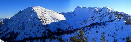
3. Schliersee-Spitzingsee-Area
Hochmiesing and Rotwand

Jaegerkamp

Aiplspitz
Brecherspitz
The Spitzingsee is located south of the lake and town Schliersee. It is a nice mountaineering area for the whole year. In summer it is a famous hiking area with the most frequented peak Rotwand. In winter it is a skiing area with a ski resort (insider tip: not much trouble) and a ski-tour-area for beginners. The ski-routes are not very difficult, but you can do a roundtrip with many summits. You can divide this area into sections, the eastern and western part. The eastern part is dominated by Jaegerkamp and Aiplspitz in the North and Rotwand in the South. The most popular peak in the western section is Brecherspitz which could be seen far away from the North.
The summits of this subarea:
- Rotwand (1.884m)
- Hochmiesing (1.883m)
- Auerspitz (1.811m)
- Ruchenkoepfe (1.805m)
- Aiplspitz (1.759m)
- Jaegerkamp (1.748m)
- Benzingspitz (1.735m)
- Tanzeck (1.703m)
- Taubenstein (1.692m)
- Rauhkopf (1.689m)
- Brecherspitz (1.683m)
- Bodenschneid (1.669m)
- Kleinmiesing (1.666m)
- Rinnerspitz (1.611m)
- Stolzenberg (1.609m)
- Roßkopf (1.580m)
- Stuempfling (1.506m)
WEBCAM OF SCHLIERSEE AND SPITZINGSEE

4. Hinteres Sonnenwendjoch-Area

Hinteres Sonnenwendjoch

Stunning view

Baerenbadalm
The mountains around Hinteres Sonnenwendjoch are located in Austria nevertheless they belong to the Bavarian Pre-Alps. They are fantastic sightseeing summits with outstanding panorama-views to the main-range of the Eastern-Alps. This is due to the fact that the southern Brandenberger Alps are lower than the mountains around Hinteres Sonnenwendjoch. The most frequented peaks are Hinteres Sonnenwendjoch and Krenspitze from Ackernalm. Ackernalm is the main origin to the routes of this subrange. Ackernalm is a nice accumulation of cheese dairies, where you can rest after summiting Hinteres Sonnenwendjoch or the southern summits.
From the top of these mountains you have a great view to the Grossglockner, the highest mountain of Austria, Grossvenediger the big glacier-pyramid, Olperer in the Zillertal-Alps and Guffert and Zugspitze in the West. Hinteres Sonnenwendjoch is also a nice ski-route in winter, but very long because the toll-road to Ackernalm and the road to Valepp are closed during the winter.
The summits of this subarea:
- Hinteres Sonnenwendjoch (1.986m)
- Krenspitze (1.972m)
- Bärenjoch (1.813m)
- Frechjoch (1.788m)
- Veitsberg (1.787m)
- Thalerjoch (1.775m)
- Wildenkarjoch (1.747m)
- Kreuzberg (1.717m)
- Schmaleggerjoch (1.633m)
- Schoenfeldjoch (1.588m)
- Joechl (1.554m)
- Larchberg (1.412m)

5. South of Tegernsee
Plankenstein and Risserkogel

Setzberg

Hirschberg

Buchstein
The scenery south of Tegernsee is dominated by the big Wallberg at the south end of Tegernsee. It is a high frequented sightseeing and toboggan mountain above Rottach-Egern. The highest summits are Plankenstein and Risserkogel south of Wallberg. On the west side of Tegernsee are the rocky Buchstein and Roßstein and also the big massif of Hirschberg a popular ski-tour-summit for mountaineers of Munich.
The summits of this subarea:
- Risserkogel (1.826m)
- Plankenstein (1.768m)
- Wallberg (1.722m)
- Setzberg (1.706m)
- Roßstein (1.698m)
- Hirschberg (1.670m)
- Grubereck (1.664m)
- Lahnerkopf (1.621m)
- Schoenberg (1.620m)
- Spitzkamp (1.604m)
- Buchstein (1.601m)
- Seekarkreuz (1.601m)
- Ochsenkamp (1.594m)
- Hochplatte (1.592m)
- Brandkopf (1.569m)
- Fockenstein (1.564m)
- Daffenstein (1.546m)
- Leonhardstein (1.452m)
- Baumgartenschneid (1.448m)
- Neuhuetteneck (1.408m)
6. Blauberge & Schinder
The summits of this subarea:
- Halserspitze (1.862m)
- Austrian Schinder (1.808m)
- Bavarian Schinder (1.796m)
- Karspitz (1.800m)
- Blaubergkopf (1.787m)
- Schattlahnerkopf (1.629m)
- Schildenstein (1.613m)
- Predigtstuhl (1.562m)
7. South of Bad Tölz, Benediktenwand-Area

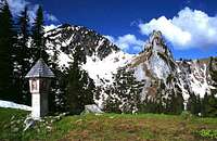
Latschenkopf from Brauneck
The summits of this subarea:
- Benediktenwand (1.800m)
- Achselkoepfe (1.709m)
- Vorderer Latschenkopf (1.670m)
- Hinterer Latschenkopf (1.667m)
- Stangeneck (1.646m)
- Brauneck (1.556m)
- Rabenkopf (1.555m)
8. Herzogstand-Area

Jochberg
The summits of this subarea:
- Heimgarten (1.788m)
- Herzogstand (1.731m)
- Martinskopf (1.675m)
- Hirschberg (1.659m)
- Fahrenbergkopf (1.627m)
- Jochberg (1.565m)
9. Krottenkopf-Area (Estergebirge)

Hoher Fricken (1.940m)

Krottenkopf from Bischof
The summits of this subarea:
- Krottenkopf (2.086m)
- Kareck (2.046m)
- Bischof (2.033m)
- Hohe Kisten (1.922m)
- Schindlerskopf (1.940m)
- Hoher Fricken (1.940m)
- Simetsberg (1.840m)
- Platteneck (1.804m)
- Wank (1.780m)
- Ameisberg (1.749m)
- Roßwank (1.688m)
- Rotenkopf (1.682m)
Climbing Areas and some climbing routes

Flintsbach

Climbing

Bad Heilbrunn
Some Climbing areas:
- Climbing area - Bad Heilbrunn
- Climbing area - Kochel
- Climbing area - Hohenburg
- Climbing area - Flintsbach
Some longer Climbing routes:
- Buchstein - Alte Südwand (IV) 200mH
- Roßstein - Some routes at Sonnenplatte (Iv+ up to VI-) 50mH
- Roßsteinnadel - Normalroute (III) 30mH
- Roßsteinnadel - East-Chimney (VI) 30mH
- Plankenstein - South Wall (V-) 70mH
- Plankensteinnadel - West-Ridge (VII-) 50mH
- Ruchenkoepfe - Duelfer (IV+) 100mH
- Ruchenkoepfe - Goettner (IV) 100mH
Toboggan in Bavarian Pre-Alps
Some toboggan routes in the Bavarian Pre-Alps:
- Wallberg to Rottach-Egern - 6,2km - 840mH
- Bodenschneidhaus to Schliersee - 6,0km - 530mH
- Bruennsteinhaus to Muehlau - 4,9km - 720mH
- Gindelalm to Hausham - 4,5km - 390mH
- Auer-Alm at Bad Wiessee - 4,3km - 450mH
- Hirschberg/Hirschlache to Scharling - 4,1km - 590mH
- Kala-Alm to Schneeberg - 2,8km - 390mH
- Blomberg near Bad Heilbrunn - 3,5km - 490mH
- Kirchsteinhuette near Arzbach - 2,8km - 220mH
- Silbertsgraben at Walchensee - 1,3km - 220mH
- Reiseralm at Brauneck - 1,2km - 270mH
- Milchhäusl at Brauneck - 1,0km - 90mH
- Denkalm at Lenggries - 1,0km - 170mH
- Half way of Setzberg to Kreuth - 2,7km - 320mH
Book of toboggan in this area:
- Georg & Rosemarie Loth: Rodeln Oberbayern und Tirol. 62 Rodelbahnen zwischen München und Inn - ISBN: 3763330097
Lakes and Rivers
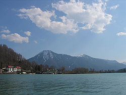
TEGERNSEE: Tegernsee is 50km south of Munich. It is a famous tourist-destination with 9 qkm. The lake was accumulated by a glacier during the ice-age.
SYLVENSTEINSPEICHER: Also known as Sylvensteinstausee (water reservoir) was built between 1954 and 1959 to protect Munich for flood water of the Isar. Sylvensteinspeicher as a surface of 4 - 6,6 qkm.
SCHLIERSEE: Schliersee is 65km south of Munich. It is 2,2 qkm big and was long time not as ecologically clear as Tegernsee. Today the water-quality is good because there were a built a recirculation in 1982.
SPITZINGSEE: Spitzingsee is 5km south of Schliersee. It is the biggest high-mountain-lake of Bavaria. It is about 28,3 hectare big.
KOCHELSEE:Kochelsee is 70km south of Munich towards garmisch-Partenkirchen. It is 6 qkm big. The lake was created during the ice-age by the Loisach-Isar-glacier. At Kochelsee is a big hydroelectric power plant.

WALCHENSEE: Walchensee is one of the biggest and deepest german lakes in the Alps. It is about 190 meters deep and has a surface of 16, qkm.

ISAR:
The river Isar is 295km long and originates in the area Karwendel in Austria and flows to the Donau. In the ancient it was used as a trade road by the Romans.
INN:
The river Inn originates in Engadin/Swiss and flows through Innsbruck to Bavaria and Passau where it goes over in the Donau.
Weather and other informations
Weather and Avalanche-Information:
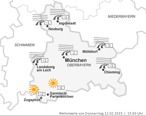
DANGER OF AVALANCHES
Camping and hotels:
CAMPING AND HOTELS IN SCHLIERSEE
Books and Co.
Books:
- Eugen Hüsler - Kompass WF 922 Tegernsee ISBN: 3-85491-357-5
- Heinrich Bauregger - Leichte Wanderungen in den bayerischen Voralpen - ISBN: 3-76584-060-2
- Heinrich Bauregger - Die schönsten Wanderungen mit Kindern in den bayerischen Hausbergen - ISBN: 3-76584-058-0
Maps:
- Kompass WK 008 Bayrischzell-Schliersee - 1:35.000 - ISBN: 3-85491-352-4
- Kompass WK 027 Achensee - 1:35.000 - ISBN: 3-85491-079-7
- Kompass WK 8 Tegernsee-Schliersee-Wendelstein - 1:50.000 - ISBN: 3-85491-010-X
- Kompass WK 08 Tegernseer Tal - 1:25.000 - ISBN: 3-85491-232-3