Previously in Four months in Peru: Stumbling through the mountains, dental problems and visiting the local hospital.
A Quick Start
Jaymie had read my note in SummitPost's Plans & Partners section and sent me a message. We started exchanging ideas, and quickly settled on the popular Ishinca valley. I wouldn't go as far as to call it crowded, but it is still one of the busier places in the Cordillera Blanca. Quite understandably so I might add: There are great hiking possibilities – especially if you don't mind a short and simple glacier crossing – some easy glaciated peaks such as Ishinca and Urus Este, suitable for novices as well as useful for acclimatization, and a number of harder ones. Of the latter, Tocllaraju (6034m) would be our main goal. We would try climbing the normal route, the NW ridge. Although one of the easiest 6000-ers in the Cordillera Blanca, it is still rated AD.
Jaymie lived in Alaska, so I had no doubts about his outdoor skills. We talked a bit about dealing with glacier hazards and about getting acclimatized. Like many, he simply didn't have a long holiday, so, to make the most of it, he wanted to start climbing as soon as possible, instead of acclimatizing gradually. He had been climbing regularly in Alaska shortly before coming to Peru. I had no idea how high he had been recently already, but I just figured that he was in a better position than me to judge how fast he would adapt to the thin air, and he was confident.
I live in Amsterdam, but after travelling and climbing in Peru for more than two months I was well adjusted to the thin air. I also knew my way around in Huaraz (3090m), so to speed things up even more, I went shopping before he even arrived. That way, he would only have to spend one night in town. The very next day we headed out, to Ishinca base camp to be precise, and sleep at 4400m on our first night in the mountains.
We had originally planned to carry our gear up ourselves, but close to the trailhead we encountered an arriero on his way down. Now, it's easy to plan to carry everything, but once you have all the weight on your back, it's different. After a pretty short deliberation, we struck a deal with the arriero. That way we could save some energy for the coming days and he earned some money, so everybody was happy - except perhaps the mules.
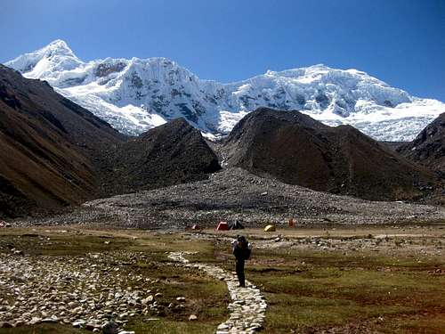
Heading out.
Ahead is Urus Oeste, the Ishinca valley is to its right | Flowers near the start
ofthe valley | At first, a big, easy trail
leads through a small forest | The glaciers are coming
intoview |
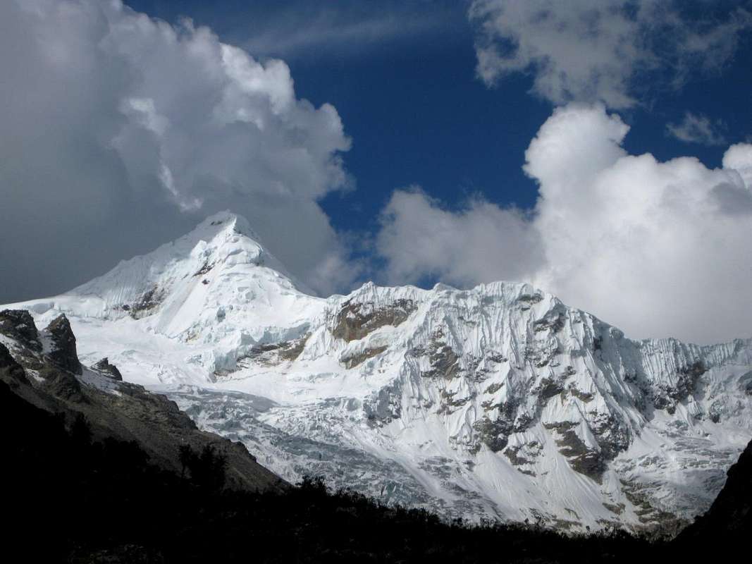
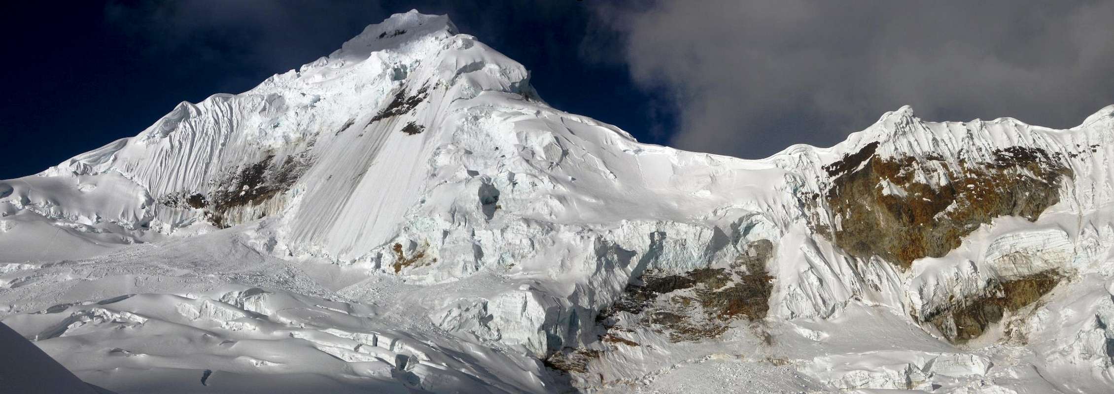
It's an easy walk of three to four hours to base camp. Early on, the trail goes through a small forest. It's pleasant enough, but the views are not spectacular. That changes dramatically when you get deeper into the valley, when the big glaciated slopes of Tocllaraju and Palcaraju command all the attention.
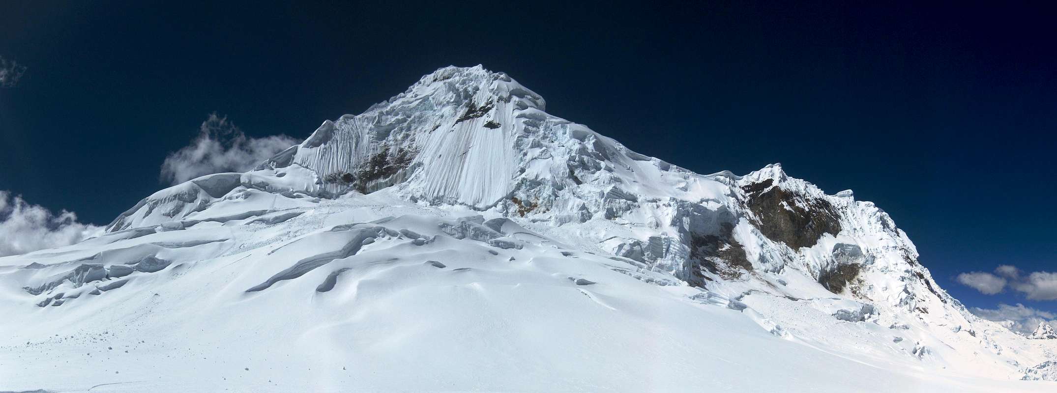
![]()
Tocllaraju dominates the head of the Ishinca valley.
Base camp is a large flat meadow, with a couple of streams running across. We saw a bunch of tents, and I imagine that, with the popularity of the valley, the water needs more than the usual care.
![Ishinca refuge]() Ishinca refuge
Ishinca refugeThe Ishinca refuge, located at the same meadow, offers a perfectly good alternative to camping. I had never visited a Peruvian mountain refuge, so I had no idea what to expect. We had brought everything ourselves, but with the intention of checking out the refuge.
It turned out to be a fine place. We gladly checked ourselves in, planning to stay there a couple of nights and do a few acclimatization climbs. The beds were nice and the food was good – although sometimes a bit slow in coming – but that's something we only would learn later. Right now, having brought so many supplies, we cooked ourselves.
Hail, Rain and Snow
Even on the approach to the refuge, the skies darkened, and shortly before our arrival it had started to hail lightly. However, as quickly as it had started, it stopped again, and we didn't even put on our rain gear. But while we were preparing our dinner, it started again, and this time the hail, and later the rain, were more serious and persistent. Ah well, I thought, it will probably be fine again tomorrow morning. Bad weather often doesn't last long in the winter season in the Cordillera Blanca. We agreed to get up at 4 am, so we could start our first climb, Urus Este, by 5.
A Belated Start
![On our way to Urus Este]() High on the small glacier of Urus Este. This prominent little peak is not the summit, or Urus Este would see much less climbers! No, I’m just looking back at Jaymie as we’re on our way up. It’s not far from here anymore.
High on the small glacier of Urus Este. This prominent little peak is not the summit, or Urus Este would see much less climbers! No, I’m just looking back at Jaymie as we’re on our way up. It’s not far from here anymore.Alas, early in the morning, the weather still wasn't too good, so we stayed in bed. We finally got up well after sunrise. During the night, the rain had changed to snow, but it must have been very light, for the snow cover was thin. It was dry now, but the clouds were hanging low. We could not see much of the walls of the valley above the refuge. Higher up, there would be no views.
We had a leisurely breakfast, not expecting to do much today. But we were restless. We simply had too much energy to sit in a refuge all day, so by 9:15 we headed out. We didn't really expect much from the day anymore, just getting a bit of exercise and improving Jaymie's acclimatization.
![Urus in clouds]() Urus Central in clouds, from the trail to Urus Este. I only learned much later that the actual summit of Central is much further back.
Urus Central in clouds, from the trail to Urus Este. I only learned much later that the actual summit of Central is much further back.
But now we got lucky. Within an hour, the strong sun changed everything. The clouds began to disappear quickly as we gained altitude, and we got rewarded for our efforts with great views.
The route to Urus Este proved easy. A bit of scrambling along the way brought us to the edge of the small glacier that covers the final 300m to the top. Only the last ten, twenty meters were a little bit steeper. I had read that it would be rocky, but there was enough snow on it to make it easy.
Overall, we didn't go fast today. Jaymie felt good enough alright, but his lack of acclimatization still slowed him down. Fortunately, on climbing Urus Este, being slow is not a problem. From the refuge, the distance is short. It's mainly a matter of ascending 1000m.
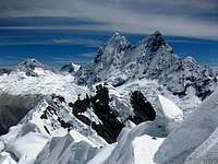
![Tocllaraju in clouds]() Despite a few remaining wispy clouds, we had a fine view of our main target, Tocllaraju, from high on Urus Este.
Despite a few remaining wispy clouds, we had a fine view of our main target, Tocllaraju, from high on Urus Este.Starting at 4400m already, that obviously takes more time than lower down, but it's still not all that much of an effort. Without pushing hard, we made it in 4.5 hours. We didn't encounter any noteworthy difficulties, and didn't even see the need to rope up. But by the time we were on the summit, we could feel we had gotten a bit of exercise in. It was good for acclimatization, an enjoyable easy climb and excellent views along the way.
![Descending Urus Este]() Jaymie descends from the summit of Urus Este. I had read that this section is rocky, but there was a bit of snow and that made it easy.
Jaymie descends from the summit of Urus Este. I had read that this section is rocky, but there was a bit of snow and that made it easy.
Now, the small Urus chain has three notable summits: Urus Este(5420m), Urus Central(5495m) and Urus Oeste(5450m). The easy summit that everybody climbs is Este. At the refuge, I asked why people do not climb Central, given that it is higher? They answered that it wasn't easy – but when I pressed for more details, they couldn't explain how difficult it really was. Quite optimistically, earlier on Jaymie and I had thought that perhaps we could traverse from Este to Central, but agreed to postpone the decision until we would be on top of Este. By the time we were up there, the decision was very easy: It was much too late, the ridge line down from Este towards Central looked difficult, and we were already too tired for such a big encore. Three reasons not to do it, each of which good enough by itself. Urus Central would have to wait...
| Views from Urus Este |
| | Ranrapalca, Ocshapalca and Janyaraju |
Tocllaraju High Camp
Next morning Jaymie still felt fine. That settled it. We left some of our supplies at the refuge and started hauling up everything else up to Tocllaraju high camp. It wasn't all that much, really. We only needed food for one night, but to give us some flexibility, we took enough for two. That didn't make our packs all that heavy.
![Heading off to Tocllaraju]() Heading off towards Tocllaraju from the refuge
Heading off towards Tocllaraju from the refuge
From what I had read, there would be several possible sites to set up high camp. We aimed for the highest option, at around 5300m on the glacier, to have a shorter summit day. Besides, it's only 900m up from the refuge. As we had all the time in the world, we left late.
![Tocllaraju]() Tocllaraju from where the trail leaves the Ishinca valley floor. Our intended summit route follows the ridge on the left.
Tocllaraju from where the trail leaves the Ishinca valley floor. Our intended summit route follows the ridge on the left.
It was obvious in which direction we had to go. However, not far from the refuge there were several trails and cow paths to choose from. Jaymie is a bit faster today and walks ahead of me. I don't like his choice of trails and pick another one. They go in the same general direction, but mine is easier, and while Jaymie contends with the rougher terrain, I catch up. A little further, he makes his way across to my trail, which becomes more pronounced again. It leaves the valley floor and heads up the slopes on our left. It's a bit steeper now, but still hiking territory. Higher up there is a boulder field tossed in for good measure. Cairns mark the way. I'm doing fine, but Jaymie gets slower and slower. The altitude is finally starting to have an effect on him after all.
After a short section on the ice at the glacier's edge, I reach a camp site on bare rocks. This is moraine camp, the site where most people spend the night. There is no water trickling down from the glacier though, so melting snow and ice is still required. It's not a big place, and there are two tents already. The views are outstanding, but it's only at 5100m, and, more importantly, it doesn't look very clean.
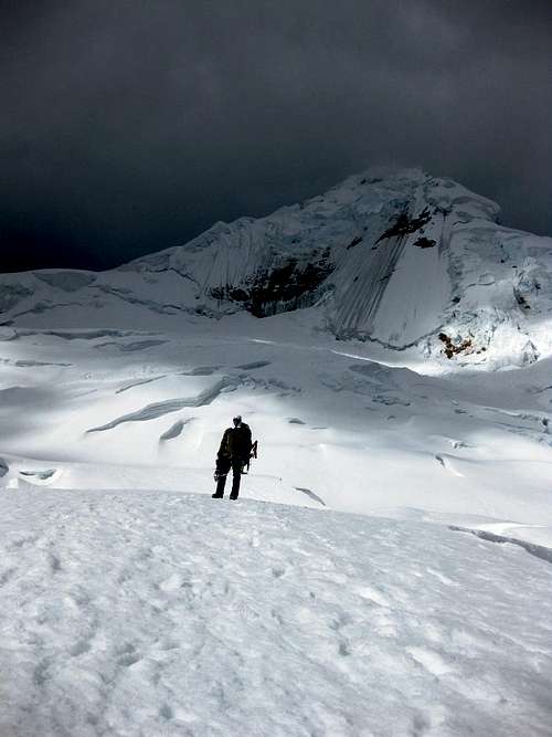
![Tocllaraju high camp]() Tocllaraju High Camp. The dark mountain in the background is Palcaraju.
Tocllaraju High Camp. The dark mountain in the background is Palcaraju.
Jaymie catches up with me. He is not feeling particularly well, but we decide to press on just a bit more. From moraine camp, the route ascends a moderately steep slope. It was tiring, but 100m higher it flattens out and we reach a beautiful plateau. It looks clean, there is room for many tents and it is far from any steep slope above us that might put us in harm's way from rock fall or avalanche danger. Jaymie is done for the day, so although still slightly lower than planned, we pitch our tent there.
The strong midday sun and lack of winds makes it a very pleasant place to be. Jaymie's primary goal now is to keep drinking, so we are melting a lot of snow. His stove proves to be very efficient at that. He has brought up a freeze dried meal, so to make dinner all he has to do was add boiling water. Since I'm in Peru for a very long time, I have to get supplies locally, and by now I have learned to cook at altitude. Today's menu is pasta carbonara, with a rich tomato and vegetable sauce, and chocolate and cookies for desert. I slip into my sleeping bag with a full tummy and very satisfied.
Jaymie is already resting, but with a big headache. He isn't worried about it himself, but I am. Nevertheless, we plan to get up at 4:30 and leave an hour later. That's pretty late actually, but neither of us is very keen to walk in darkness for hours, when you can't enjoy the scenery. Besides, it's very cold in the early hours before sunrise.
| Views from Tocllaraju High Camp |
Urus Oeste, Central and Este | A dark view of Akilpo Sur | | Laguna Toclla and Nevado Ishinca |
![]()
Tocllaraju panorama from high camp. The NW ridge is on the left.
An Unplanned Rest Day
As it happened, we both woke up around 4. Jaymie's head didn't feel any better. He took a paracetamol and a diamox and we went back to sleep.
The next time we woke up, it was already light. We had both failed to hear the alarm. Rather late to start, but not impossible – and without the cold, more enjoyable even – but often the clouds move in during the day, so we might not have a view. In addition, not knowing the mountain yet, we couldn't tell if low visibility might give us route finding problems on our way down. However, it didn't matter. With Jaymie's headache, going higher was out of the question. It wasn't so bad that he wanted to descend, but the summit was definitely not on for today.
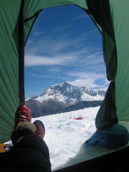
![Copa from Tocllaraju high camp]() The summit of Nevado Copa early in the morning
The summit of Nevado Copa early in the morning
The sun was shining brightly and the mountains looked beautiful again. It certainly was no punishment at all to have to spend another day up there.
Even before 10 am, two climbers descended, on their way down from the summit. We were having breakfast as they passed our tent. I asked
"How has it been?" "Ccccold!" was the answer.
"When did you leave?" "At 2". That reinforced us in our plan not to start too early; there really is no need to be back down at 10!
I had too much energy to do nothing all day, so a few hours later I headed out to recon the lower part of the route, and to get a head start on taking pictures.
The first hour and a half were easy. The clear trail had crossed a few crevasses, small enough to step over. Now I got to a bigger crevasse. Too big to step over or jump, but there was a solid looking snow bridge. Directly across was a short slope of about 40º. Not difficult, but it certainly made me focus: a slip would land me straight in the crevasse!
![Bad camp site]() Sure, it’s flat here, but nevertheless this would be a bad camp site...
Sure, it’s flat here, but nevertheless this would be a bad camp site...
A little further the route came to a near vertical ice wall. It wasn't high, but too steep to climb easily and so the route turned, heading towards an area littered with blocks of ice, the tell tale signs of an old avalanche. Enough scouting out the route, I concluded. Before going back, I sat down below the ice wall to enjoy the views – and a bit of chocolate.
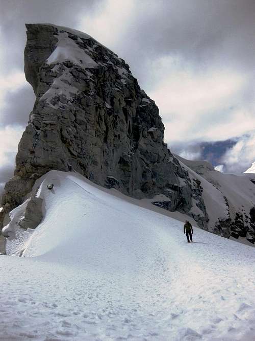
![The start of the NW ridge of Tocllaraju: looks a bit tricky to me!]() From where I turned back, I had a good view at where we would have to get on the NW ridge
From where I turned back, I had a good view at where we would have to get on the NW ridge
The strong sun – no clouds developed today – had softened up the top layer of the snow. Just a few centimetres though; not enough to sink deeply or seriously compromise any snow bridges, but very suitable for a very quick descent. I walked, slid and even managed to ski a bit on my boots – surprising, considering I was still wearing crampons, but that just illustrates what the snow was like. In 20 minutes I was back at our tent.
![Tocllaraju high camp]() Our friendly Swedish neighbours have joined us at high camp at 5200m. The plateau is big enough not to feel crowded at all.
Our friendly Swedish neighbours have joined us at high camp at 5200m. The plateau is big enough not to feel crowded at all.
By now, another group of climbers had appeared. They were setting up camp on the same plateau. I walked over to them, and to my surprise they were the Swedes that I had already met twice before – first a week ago, in the Quilcayhuanca valley, and later in Cafe Andino in Huaraz, where they had surprised me when they told me that they had actually followed my trail up Jatunmontepuncu a day later!
Jaymie had another freeze dried meal, while I whipped up another pasta, a veggie one this time. Without the meat, it didn't quite taste as good as yesterday, but it still hit the spot. Even before it was totally dark (around 6 pm), we were in our sleeping bags again.
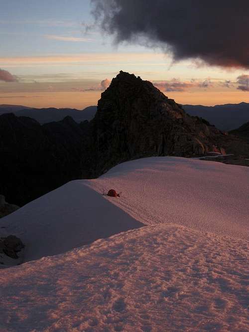
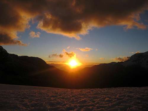
![Sunset in the Cordillera Blanca]() Sunset from high camp
Sunset from high campGoing for the Summit
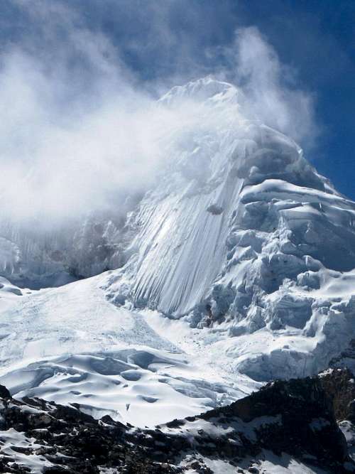
![Gaining the NW ridge on Tocllaraju]() Just below the bergschrund
Just below the bergschrundJaymie is the first to wake up.
"What time is it?", he asks.
"A quarter to five", I reply. Again we had failed to hear the alarms, but this time we overslept only by a quarter. Not bad! However, when I have a second look, I see it is a quarter to
six! Ah well, after meeting the descending climbers yesterday, I had figured we could even start at 7 and still have enough time to make it back down all the way to the refuge. But whether we would have a view on the summit...?
By 6:48 we are on our way.
In the distance, just before the trail gets on the ridge, we spot a few other climbers. Something nice to aim for, even though they are too far away to catch up.
Until the bergschrund that guards the access to the ridge we make good time. It isn't steep anywhere. Above the avalanche debris field dotted with ice, where I had turned back yesterday, we enter unknown territory, but still we don't see all that many crevasses.
Once we reach the schrund, we first look at the wrong place to cross. For the most part, the crevasse is quite small, but on the other side it is very steep. Since the snow and ice are firm, it isn't obvious where the trail continues. We still may be able to cross where we are, but on the other side we will be forced to use brute strength on a steep section that ends with a slightly overhanging bit of ice. Since it is very short, we think we can climb it before running out of power, but while we are mentally preparing ourselves, Jaymie fortunately spots that we had missed an easier way across the schrund. On the other side it is still steep, up to 70º for about 5m, but this time there is no overhang at the top.
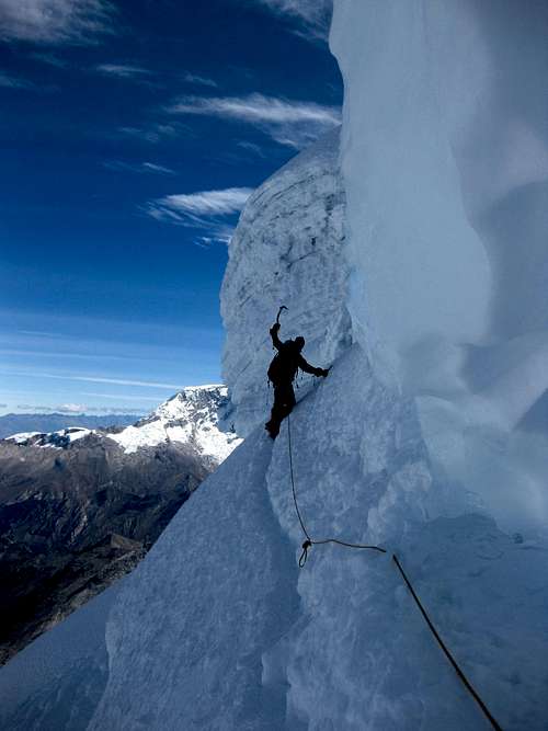
![Jaymie leads on Tocllaraju]() Climbing the steep section right before gaining the NW ridge
Climbing the steep section right before gaining the NW ridge
After this interesting part, there is a short traverse, followed by a longer pitch, approaching 60º at the bottom but easier higher up. Despite the steepness, it isn't difficult at all. The snow is solid, giving excellent purchase, and it is easy to kick in our crampons and swing our ice tools. In a steady rhythm we climb higher, and before long we are on the northwest ridge.
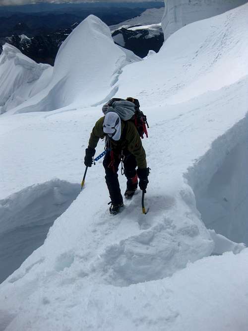
![Getting easier]() Having a break low on the ridge
Having a break low on the ridge![Dangerous cornices on Tocllaraju]() Higher up, a small and heavily corniced ridge joins the NW ridge from the north
Higher up, a small and heavily corniced ridge joins the NW ridge from the north![Big snowbridge]() I'm already across the snow bridge, Jaymie follows
I'm already across the snow bridge, Jaymie follows
It's wide. I mean, you have knife edge ridges and more normal ones, but this one is so wide, I imagine that, in poor visibility and without a trail, you can actually get lost on it. It isn't particularly steep, so we simply walk up. We meet a few parties of other climbers on their way down. We are the last ones going up today.
Occasionally we encounter a crevasse, and higher up, at a bigger one, once more we do not immediately see where the trail goes across.
I think I can jump it. Standing at the edge, to have a good look, I'm not totally sure anymore that I can make it to the other side, so we will have to set up a belay, just in case. But once more, before we do it the hard way, Jaymie spots a snow bridge further to the right. It's looks secure enough and it's clear that the trail goes over it. Just in case it suddenly collapses under me, I keep an ice tool ready in each of my hands while I head across.
![Jaymie on the last pitch below the summit ridge on Tocllaraju]() Jaymie ascends the steep slope just below the summit. We climb unroped instead of belaying, so we can be faster.
Jaymie ascends the steep slope just below the summit. We climb unroped instead of belaying, so we can be faster.
Shortly after that, we already find ourselves at the bottom of the summit pyramid. It's one pitch, getting steeper gradually, up to 60º just before the top of the slope. Again the hard snow makes it pretty easy. I had expected this to be the crux, but the steep part just above the bergschrund, on our way to the NW ridge, had actually been harder.
From the top of the slope, it's only a matter of minutes. A short walk on an exposed ridge – small, but not quite a knife edge – brings us to the summit. We get there after 5 hours and 45 minutes – and just in time to see the clouds start to hide the higher summit of Palcaraju (6274m) to the east. We still have clear views from our lofty but nevertheless lower vantage point at 6034m.
![Palcaraju summit pyramid]() The summit of Palcaraju is disappearing in the clouds
The summit of Palcaraju is disappearing in the clouds
After enjoying the summit, and feeling pretty good about ourselves, it's time to go down. So far, we had climbed the steep sections free – had we roped up, we would have had to belay as well which would have slowed us down, and we felt comfortable climbing free – but Jaymie, getting a bit tired now, preferred to descend using the rope on the steep pitches. There were snow anchors in place, which I used those to lower him down, then I climbed down after him.
Despite the bright sun, on the occasional harder stretch of snow on the ridge we had to look closely to find the traces of the trail. Imagine having to descend that in a whiteout!
We made it down to the bergschrund in good time and without incident. From above, finding the right place to cross was easy – albeit still 70º steep those few meters. Climbing down that part got my adrenaline pumping again; it felt different than on the way up! Maybe looking down into the schrund had something to do with that?
Without incident we got back to our tent. The descent had taken us a total of 2.5 hours.
We relaxed and ate some soup. Had it been too late, or had we been too tired, we could have stayed there another night. With hardly any food left, we would be hungry, which would be a minor inconvenience. But there was still enough daylight, and we had enough energy to keep going, so, as planned, we broke camp and headed down.
![Looking back at Tocllaraju]() Looking back at Tocllaraju as we are about to go back to the refuge
Looking back at Tocllaraju as we are about to go back to the refuge
We were slow now, but still caught up with a few other climbers that we had met earlier in the day high on the NW ridge. Eventually, we had to don our head lights, and reached the refuge shortly after nightfall. It was no problem: below the boulder, field high on the route, the terrain is easy enough. Mind you, tired or not, even on the trail you have to stay focused, for you could still take a nasty fall.
Not surprisingly, although we now had plenty of food again, we indulged ourselves in what the refuge had on offer. And that tasted pretty good!
Hiking Out
Thanks to the nice beds we woke up well rested the next morning. There was a thin layer of fresh powder outside the refuge – perhaps one centimeter. In fact, it was still snowing lightly. It wasn't really cold though, and soon it changed to a wet drizzle.
We only had to hike down and out of the valley today. The trail would be real easy and we could do so in pouring rain, but we had plenty of time to wait a bit. We ordered breakfast in the refuge – and then some more. Those fried eggs went down easily! And, sure enough, before long the weather improved and it got dry.
The hike out was uneventful and fast, and the taxi we had ordered turned up at the trailhead right on cue, just minutes after we got there. By mid afternoon we were back in Huaraz. After a much needed shower, that left us with plenty of time to grab a bite – or two – and then to start planning more adventures. But that's another story.
The story continues here: From a vanished trail on Chopiqualqui to a freeway on Pisco
Panorama of Tocllaraju, taken during my reconnaissance hike. If you look closely, you can see where the trail gains the NW ridge.
Move the mouse over the right area and see what happens! |
A Few Notes about Eating in Huaraz
The central market and the many small shops in the surrounding streets sell all the supplies you need if you want to provide for yourself, except freeze dried meals. If you still need something, there are a couple of small supermarkets in town as well. No big ones yet, at least not while I was there, but that's probably only a matter of time.
I liked Cafe Andino for the relaxed atmosphere, the library and the food - although sometimes it would take quite a while to appear. In the evening, you can easily meet other climbers and hikers.
On rest days, if I wasn't organizing something or checking my messages, in the morning I liked to hang out at California Cafe, and sometimes I stayed well into the afternoon. It's a fine place to have a second breakfast or lunch, read a book from their fine selection and chat with other tourists.
My favorite place to eat was
El Horno. The food is excellent, and the owner as well as the staff work hard to please the customers. I still remember how the waitress looked one time when I popped in for lunch and ordered a pasta
and a big pizza. They do sometimes run out of desert though, or at least the ones I liked most...


Comments
Post a Comment