
|
|
Mountain/Rock |
|---|---|
|
|
44.32330°N / 15.56830°E |
|
|
Hiking, Mountaineering |
|
|
Spring, Summer, Fall, Winter |
|
|
5745 ft / 1751 m |
|
|
Google Earth
Since Google has blessed us with its magical Google Earth software you can visit any corner of the world from the chair parked in front of your computer. Thankfully Velebit is amazingly clear so you can discover its corners and see for yourself how it looks from the above and where are the places this page is dedicated to.Each geographical point of interest described on this page has coordinates on the top of its section. You can use these coordinates with Google Earth’s fly to search engine. Just copy the coordinates (like it is written, with coma) and paste them into fly to tab and press enter. And, of course, enjoy the flight!
Sveto Brdo (1751m)
44°19'39.33"N, 15°34'9.50"E Sveto Brdo (1751m) from Veliko Mocilo above Mala Paklenica valley
With 1751m, magnificent pyramid of Sveto Brdo (Holly Mountain), ranks second on the list of highest peak of Velebit, only behind Vaganski vrh (1757m). Sveto Brdo is probably most recognizable peak of Velebit. Its high, self standing pyramid, visible from few hundred kilometers away, is placed on the SE end of 10 kilometers long Vaganski Vrh - Sveto Brdo group, which rises mainly above Velika & Mala Paklenica valleys and contains all of Velebit highest peaks which exceed 1700 meters.
Sveto Brdo is quite steep, especially above eastern, continental side. It rises some 1200m, straight from the Lika plateau/region. Slope, which is under beech forest till 1400m, ends with cliffs and scree at more than 60° angle. From all other sides pyramid of Sveto Brdo is grassy with some dwarf pine colonies. On the SE, over 400 meters lower, are Dusice basin while on the SW is Libinje plateau and Orljaca valley, some 1000m below.
Sveto Brdo or Holly Mountain got its name because people used to believe that during the storms Divine and Evil forces are having showdowns up there. 4 meters high steel cross is standing on the summit today together with God's 10 commandments.
Sveto Brdo is first class view point, the best on Velebit and it can be called panorama king. On the mountain that has so many great viewpoints it is not easy to pick one. But view from Sveto Brdo is actually amazing. It is because Velebit nowhere has a simple main ridge except here so nothing obscures the view. On clear days (and here there are many of them) view spreads few hundred kilometers and is most beautiful towards sea and hundreds of islands in the distance. On very clear days you can see Apennines mountain range with their highest peak and highest peak of Italian peninsula (the boot), Corno Grande (2912m), which is some 270km/170miles away. Detailed view description is in the section below.
 Sveto Brdo in winter
There is nothing technical in any of routes leading towards Sveto Brdo. But on the other hand, they are all long with huge altitude difference and demand good shape. The easiest route is through Velika Paklenica, while toughest is through Mala Paklenica, which takes 9 hours and it is impossible to do both ways in a day. All routes offer completely different scenery.
When comparing with other popular alpine peaks, not many people climb Sveto Brdo or Velebit in general. North Velebit is much more visited. Here, on South Velebit, it is quite unlikely to meet many, if any people, especially on higher elevations, except in peak season (July and August). Only the route via Velika Paklenica is quite crowded in summer, but only up to mountain hut in Paklenica. Velebit is place where you will find nature in its primeval form and enjoy peace, far from crowded centers.
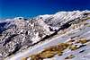
 Sveto Brdo (1751m) in winter, from NW
 |  |  |  |  |  |  |  |
Panorama of Velebit & Sveto Brdo
 |  |  |  |
See another panorama of Velebit here
Sveto Brdo from Distance
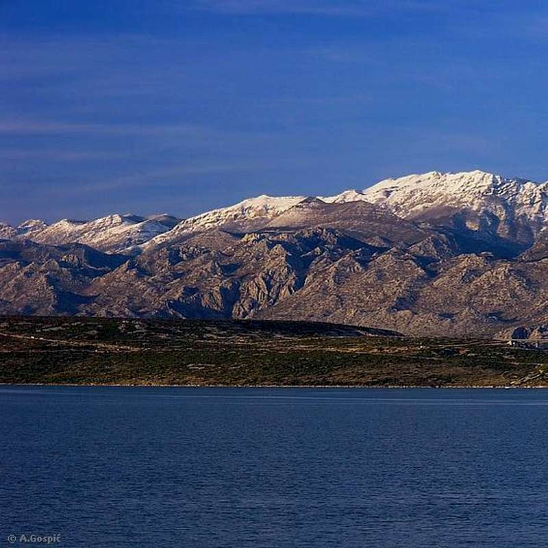
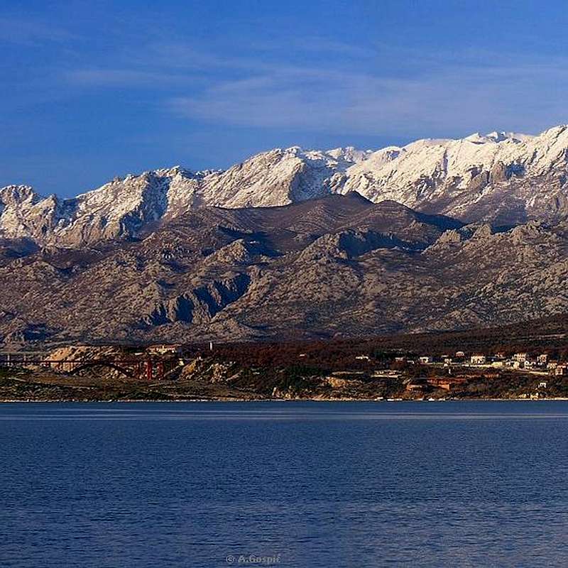
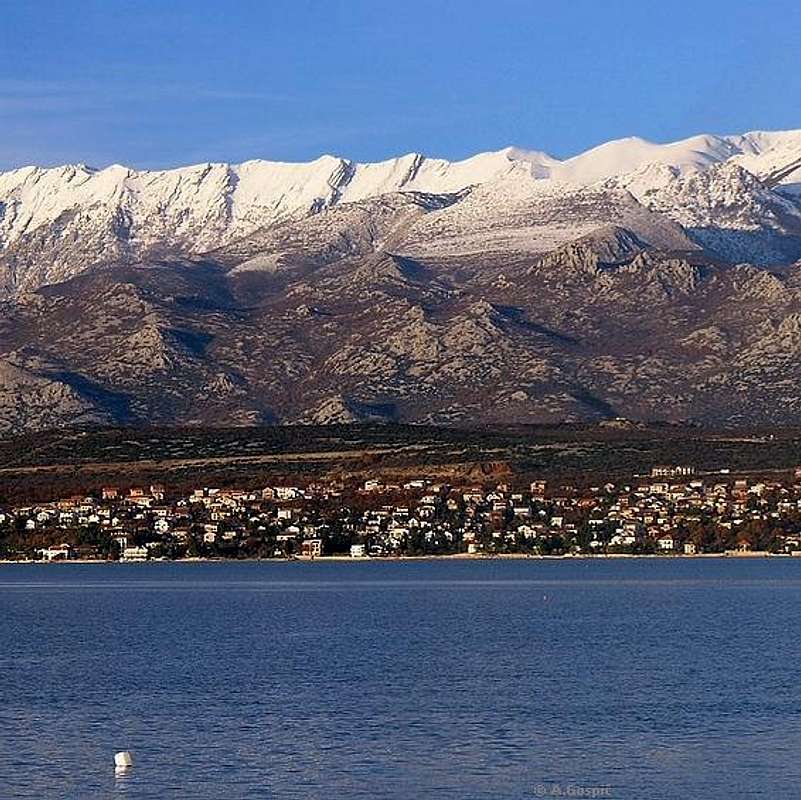
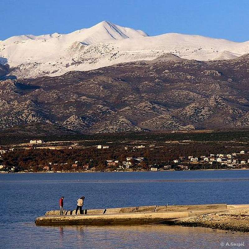
 Velebit and Sveto Brdo (1751m) from Karinsko More sea
Distant views of Sveto brdo
 |  |  |  |
Views
 Cross on the summit of Sveto Brdo (1751m) and sea view
Sveto Brdo is undisputed Panorama King of Velebit which has 360° open views in all directions. Thanks to its unique position close to the end of South Velebit and highest peaks group panorama is very diverse. Also on Sveto Brdo you have a feeling like being on at least 2000m as the world below really seams like a miniature 3D model. Whole length of Velebit can be seen from here, greatest number of islands, whole of Zadar and Kornati archipelagos are right on your palm. Houses are tiny dots, roads are like a hair, and even great Maslenicki most bridge looks like part of Lego-land.
NW: Velebit, all the way to it’s beginning at Senjsko Bilo (1492m - 80km away)
N: Lika plateau, Velika (1534m - 130km) & Mala (1279m - 100km) Kapela mountains behind it
NE & E: Lika and long ridge of Licka Pljesivica mountain (1657m - 40 to 60km) behind it, which is closing the horizon. Lika is split in half by the Licko Sredogorje range (1233m - 20km). In eastern direction are Osjecenica (1795m - 60km) & Klekovaca (1961m - 90km), mountains in Bosnia
ESE: Lika plateau with Gracac town (20km) and blue Ricica Lake near it.. Behind the Gracac are last parts of Licka Pljesivica mountain (35km). Further behind are Ilica (1654m - 55km) & Sator (1872m - 80km) mountains in Bosnia
SE: Velebit till its end: Celavac (1189m - 20km) with TV tower and Crnopac (1404m 25km) behind it. Right of Crnopac, much lower, are last parts of Velebit (45km). Behind Velebit end is very wide Dinara mountain, with Dinara group/peak (1831m - 80km), highest in Croatia. On the same ridge, little bit right of Dinara peak is Troglav (1913m - 100km), which is highest peak on Dinara but belongs to Bosnia, and further right on the same ridge is Kamesnica (1855 m - 130km), last part of Dinara mountain. Right of Dinara, behind huge north Dalmatian plateau, is Svilaja (1508m - 90km) and smaller Promina (1147m - 70km) mountain. Just behind Promina is Biokovo mountain (1762m - 170km). Right of Promina is Mosor mountain (1339m - 125km), which is above Split city
SSE: Wide north Dalmatian plateau and islands of Sibenik archipelagos (70 - 80km)
S: Just below Velebit is end of Velebit channel. Novsko Zdrilo gorge is bridged by Maslenicki Most bridge (10km). Behind it, like two lakes, are larger Novigradsko More sea and smaller Karinsko More sea. Behind and above Karinsko more sea is small Orljak mountain (674m - 25km). Behind Novigradsko more sea in large plateau of Ravni Kotari with Vransko Jezero lake (45km) and islands of Kornati archipelagos (60km)
SW: Ravni kotari plateau and Zadar city (40km) on their edge (churches and buildings are easily recognizable). Islands behind Zadar channel belong to Zadar archipelagos (45 to 65km). On very clear day Apennines range with their highest peak Corno Grande (2912m) are visible (270km/170miles away)
W: sea and islands (70 - 100 km)
 Sunset on Sveto Brdo


 |  |  |  |  |  |
Babin Vrh (1744m)
44°20'20.90"N, 15°33'49.52"E Babin Vrh (1744m), third highest peak of Velebit, and Lika
Babin Vrh is close neighbor of Sveto Brdo (1km away) and 3rd on the list of highest peaks of Velebit. It has a shape of a pyramid with flat top which stands on broad stand. Babin Vrh is connected with Sveto Brdo by narrow and very panoramic ridge which contains two more heads above 1700m. Towards N & E Babin Vrh falls uninterrupted some 1200m to Lika region. On the SW is Doci basin on the main ridge of Velebit while on the NW is Ledena Draga, small valley on the crest of Velebit. Because Babin Vrh and the ridge between it and Sveto Brdo are excellent view points it is worthy and highly recommended detour of last portion of Mala Paklenica & Velika Paklenica routes to Sveto Brdo or added circle to Modric route.
Babin Vrh is almost unvisited peak. Very few have desire to visit it. Most are satisfied with neighboring Sveto Brdo, which is primary goal on this part of Velebit. Main reason lies in fact that approaches to Sveto Brdo are long and tiring so almost no one has any more time/energy/will to climb Babin Vrh too. Beside the fact that it is lonely, unmarked and pathless peak Babin Vrh offers fantastic panorama. If you sleep over at Vlaski Grad refuge you will have no problem to add it to Sveto Brdo on the next day.
View from Babin Vrh is especially beautiful upon continental side of Velebit. 400m below the summit is beautiful rounded grassy meadow Dolina Cubrilova (1320m) towards which Babin Vrh falls almost perpendicularly. Also not visible from Sveto Brdo is beautiful Bunovac (1187m), 2km long undulating grassy valley which is placed on the continental terrace of South Velebit, below highest peaks of the group. Malovan (1709m) & Segestin (1715m) are towering above it while further behind is Vaganski Vrh (1757m), highest peak of Velebit.
 Babin Vrh winter view
Access. It takes around an hour from Sveto Brdo to Babin Vrh or vice versa via the panoramic ridge. It is best to do it on the return from Sveto Brdo if you are heading back towards Paklenica area or towards Vaganski Vrh. If you are descending towards Vlaski Grad refuge it is the same which way you’ll do it because when climbing both peaks you’ll close a circle around Doci basin which is placed on the ridge of Velebit and return to marked VPP trail, close to junction towards Vlaski Grad pass.
One point of leaving or returning to marked path (VPP) is Sveto Brdo. The other is at the foot of nameless grassy peak (1710m) which stands between Babin Vrh and VPP trail. There is small pass between this nameless peak and Obla Glava (1557m) grassy head. Pass is just 10mins away from the junction where path from Vlaski Grad (Modric route) joins VPP (both Paklenica routes) and is crossed by VPP trail (Paklenica direction from the junction). From the VPP it takes around 40mins to Babin Vrh.
 |  |  |  |  |
Debelo Brdo (1441m)
44°18'45.56"N, 15°34'33.73"E Sveto Brdo (1751m) and Debelo Brdo (1441m) from Libinje
Debelo Brdo means Fat Mountain. First SE neighbor of Sveto Brdo really is that. Debelo Brdo is enormous grassy mountain that rises over 600m above Libinje plateau on the SW (towards sea). It is over 2km wide. At its back, or on the NE, undulating grassy plateau of Dusice is placed. Above it ridge of Debelo Brdo rises only around 100m. On the NW Debelo Brdo is attached to 300m higher pyramid of Sveto Brdo, which from this direction shows its most impressive face in terms of size and grandeur. Summit ridge of Debelo Brdo gradually descends towards SE and is with shallow pass, over which old path ascends from Libinje towards Dusice, separated from Biljevina (1340m). Together they form seaboard streak of peaks which disappeared in the region between Vaganski Vrh and Sveto Brdo.
Although Debelo Brdo appears soft there is lot of rock mixed with grass, particularly on lower slopes. In the mid part of huge SW slope above Libinje there is thin belt of rocks or even smaller cliffs which stretches horizontally along whole slope. On the NW or left end when observed from sea direction is larger group of cliffs called Kruzli. Just below it some beeches grow. It seams they found at least some protection from fierce Bura wind which rules on these slopes. Because of it snow never holds on the summit ridge. Only little bit which glues to grass or rock. Everything else is blown away.
Over Debelo Brdo leads most direct, but pathless variation of Modric route. Orientation is easy on open grassy spaces but it is only for those in good shape because of steepness and quite difficult mix of rock and grass, also length. Ridge of Sveto Brdo is also much more difficult here than terrain where marked route ascends. Those that choose this way are rewarded with fantastic views towards Libinje plateau, sea & islands and most beautiful display of Sveto Brdo.
 |  |  |
Dusice
44°19'18.38"N, 15°35'10.51"E Sveto Brdo (1751m) from Dusice (1300m)
Dusice (read Dushice) means lot of small souls (plural of dusica, which means small soul). It is undulating grassy basin/plateau with one larger compact area and many small funnel shaped basins in which are small beech groves. Average altitude of Dusice is around 1340m. This is very romantic, tame and peaceful spot. Trademark of Dusice is huge pyramid of Sveto Brdo (1751m), which rises over 400m above it and closes it from NW. On the SW is long ridge of Debelo Brdo (1441m) while on the NE are forested Veliko Bilo (1500m) and Malo Bilo (1425m). They are part of inland streak of peaks which again appears after Sveto Brdo. On the SE is undulating area of peaks which gradually descent towards Mali Halan (1045m) pass, that is border with SE Velebit. In this area highest peak is Veliki Golic (1371m).
From Mali Halan marked route used to lead via Trolokve to Dusice and further towards Sveto Brdo. Before Dusice route was joined by Liscani Bunari route which ascended from Sv.Rok in Lika. This was easiest Sveto Brdo approach but is unfortunately closed after the early 90’s war because of possible mines. It is also not advisable to go on Dusice either except in winter when snow is deep. There are some humanitarian actions in process to clear Velebit of mines more quickly because inhabited areas have advantage. Hopefully this Sveto Brdo approach will be cleared in future to come because of magnificent Dusice.
 |  |
Libinje
Malo Libinje 44°17'37.69"N, 15°33'18.92"ELicki Doci 44°18'4.46"N, 15°33'56.02"E
Veliko Libinje 44°17'21.17"N, 15°34'54.75"E
Zjaca 44°18'1.15"N, 15°35'5.54"E
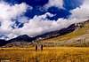
 Curious donkeys on Libinje plateau
Libinje is large plateau placed behind the peaks of 1st step and seaboard streak of peaks, it has dimensions around 3x2.5km. Plateau is predominantly rocky but there is some grass between rocks and few grassy fields. Libinje have few levels. It used to be extensive pasture for thousands of cattle in summer months but this way of living died some 30-40 years ago. Today there is large group of horses on Malo Libinje that wander here freely. People from Modric own them but now they are almost semi-wild.
On the NW is Malo Libinje (750-850m) (small Libinje). Orljaca valley separates is from Paklenica area and Jerkovac – Vrsina group. On the SW is Sopanj (790m), rocky peak placed in the 1st step streak. Gigantic Debelo Brdo (1441m) closes it from the NE. On the SW edge, towards sea, is nice and quite large Malo Libinje field, which gave name to whole area of Malo Libinje. In the field there is fertile soil which was cultivated when people used to live here during summers. Also there are few small shepherds houses not only on the field but on few spots across Malo Libinje area. On the W corner of the filed are few houses of Knezevici hamlet. Just below Debelo Brdo is another flat grassy field called Licki Doci. Between these two main fields is large undulating, predominantly rocky area. Over Malo Libinje leads Modric route towards Vlaski Grad and Sveto Brdo.
Veliko Libinje (950m) (large Libinje) is SE of Malo Libinje and is placed 100m higher. It is undulating area, larger than Malo Libinje but also more rocky. There are several smaller fields that are mostly fenced with rocky fences we call suhozid, which would mean dry wall. Veliko Libinje have more houses which are today mostly falling apart. Above Veliko Libinje there are several rocky peaks. Oscenica (1025m) (read Oshchenica) rises above both Libinje. On the N is rocky cone Covik (1120m) (man in Dalmatian accent of Croatian). It and nameless rocky head (1090m). Between them is pass over which path leads to grassy valley Zjaca, which is highest level of Libinje area. Zjaca is placed below large grassy slopes of Debelo Brdo (1441m), Biljevina (1340m) & Kruh (1311m), which are part of seaboard streak.
 |  |  |  |  |  |
Hike Advices
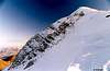
 Sveto Brdo summit in winter edition
At this point I must concentrate hard because numerous options are buzzing through my head. Number of combinations is really huge and each route has something special. If you like open spaces and panoramas choose Modric route. What about complete wild wild wilderness (am I repeating myself), far from crowds? Like it? If yes Mala Paklenica route is for you. Do you like sound of water which thunders through 400m deep canyon with wild cliffs above it? Or you like beautiful forest and gradual climb? If yes choose Velika Paklenica route. Would you like to see all of this and plus that climb highest peak of Velebit? See what I mean? Most important thing is that Sveto Brdo is really tough 1 day bite. Altitude difference is impressive 3600m! But if you want to test your knees do it via Modric route because it is shortest and if you don’t want to walk during night wait the time of year when day lasts at least 12h. It is best to do it in at least 2 days but if you have time extended your trip to 3 days and explore more of beautiful Velebit.
1) Modric and Mala Paklenica routes: Start in the morning from Modric and reach Vlaski Grad refuge (5h). Leave all the unnecessary things at refuge and continue light towards Sveto Brdo (1.40h). If you were fast and still have couple of hours to spare till dark from Sveto Brdo go to Babin Vrh via unmarked panoramic ridge (1h) and descent to Vlaski Grad refuge (1.30h). On the 2nd day head towards Ivine Vodice refuge (1h) and further via Veliko Mocilo to Mala Paklenica and through its canyon to Seline on the coast (6.30h).
In opposite direction on the 1st day through Mala Paklenica reach Vlaski Grad refuge (7.30h). Climb Vlaski Grad (1375m), 20mins above the refuge and observe the sunset from its summit. On the 2nd day continue light towards Sveto Brdo and return via Babin Vrh as in the upper combination (3.45h circle). From Vlaski Grad descent to Modric (4.30h).
Note: If you are in the group with at least two cars leave one at the trailhead of returning route before starting from the other. If such luxury isn’t possible wait for the bus at Adriatic Road. Oh yes, there is always good old hitch-hiking.
2) Both Paklenica canyons & 3 highest peaks of Velebit: on the 1st day through Mala Paklenica reach Vlaski Grad refuge (7.30h). Climb Vlaski Grad (1375m), 20mins above the refuge and observe the sunset from its summit. On the 2nd day continue towards Sveto Brdo. When you reach VPP or Velika Paklenica route (40mins above the refuge) turn left to the small pass (10mins) where you will leave unnecessary things and do Babin Vrh and Sveto Brdo light (1.45h). From the summit of Sveto Brdo return to this point via normal route (1h). If Babin Vrh is not interesting to you and you want to make long day little bit easier just climb Sveto Brdo directly and return the same way. Continue towards Vaganski Vrh (opposite direction of Vaganski Vrh – Sveto Brdo route, 3h). From Vaganski Vrh continue towards Struge refuge (opposite direction of Struge – Vaganski Vrh, 2h). 3rd day is relatively easy as you have to only descent to Paklenica hut (2.30h) and further to Velika Paklenica canyon (1.30h) or Starigrad Paklenica (2.15h). If you want to use this day to maximum you can climb Viserujna (1632m) from Buljma pass (20mins from refuge), then right in opposite direction of Viserujna – Buljma route, unmarked terrain, 3h back to Buljma).
This combination can be done the same way in opposite direction but it is easier to descent through Velika Paklenica than through wild Mala Paklenica canyon.
What about the car? Same as in the 1st trip.
3) Velika Paklenica & Modric routes: this is easiest of 3 combination. On the 1st day climb Sveto Brdo via Velika Paklenica route (7.30h) and descent to Vlaski Grad for well deserved sleep (1.20h). On the 2nd day climb Vlaski Grad peak (1375m), 30mins above the refuge. Descent to Modric (4.30h).
In opposite direction on the 1st day climb Sveto Brdo via Modric route (6.30h) and return to Vlaski Grad for the night (1.20h). On the 2nd day head towards Ivine Vodice refuge (1h) and descent to Paklenica hut (2.45h). From the hut it is 1.30h to parking in canyon or 2.15h to Starigrad Paklenica.
What about the car? Same as in the 1st trip.
4) Multiple areas: combinations above where only done inside Paklenica area. If you want to extend your trip and get to know larger part of Velebit see ‘Hike Advices’ on Stap, Visocica (1619m) or Viserujna (1632m) & Rujno pages.
 Below Sveto Brdo
 |  |  |  |  |
Getting There
By PlaneClosest airport is in Zadar, 45 km away. There are no international flights to Zadar (except charter flights during summer season) so you have to go over Zagreb international airport. There are everyday flights from Zagreb to Zadar except on sunday. They are usually in the evening, around 20h.
More info about flights on official site of Croatia Airlines
By Bus
If you are coming by bus from Zagreb you can look for time table towards Zadar on the pages of Zagreb bus station
There is no direct bus to Starigrad Paklenica from Zagreb. You have to board the bus to Zadar (ask for the line that avoids the highway) and get out on Maslenicki most bridge and wait here for the bus towards Rijeka or, of course, you can hitch-hike to Starigrad Paklenica, which is 15 km from here. If there is only a line that uses highway you'll have to go all the way to Zadar and get the bus to Starigrad Paklenica there. Third option is to beg the driver to stop on the highway at Maslenicki Most bridge, maybe he'll do it.
By Train
Train is not a good option if you are coming from Zagreb. It travels longer than bus and you have to change the train in Knin towards Zadar and than take a bus to Starigrad Paklenica. Croatian railways site.
By Car
There are 2 main directions to come to this area, from Rijeka or Zagreb.
From Rijeka, along the coast:
This route is suitable if you are coming from western Europe, via Trieste (Italy).
Trieste - Rijeka 70 km
Rijeka - Starigrad Paklenica 180 km
From Zagreb:
This road is suitable if you are coming from eastern or central Europe via Ljubljana (Slovenia), Maribor (Slovenia) or Budapest (Hungary).
Ljubljana - Zagreb 138 km, Maribor - Zagreb 113 km, Budapest - Zagreb 347 km
Zagreb - Starigrad Paklenica (via Plitvice and Gracac) 272 km
 |  |
Maps
 |  |  |
When To Climb
 In memory of Zoran Skracic, Miro Duplancic and Ivo Milun
Any time of the year is fine if forecast is good.
But be careful and don't underestimate the mountain, especially in winter. Do not go up there, if forecast is bad, even in summer. Climate of Velebit, especially of its high part, is very harsh (half of the year temperature is below 0°C). Mountain is border between continental and Mediterranean climate. Their collision can often be wild. This results in 187 days per year in clouds. Main ridge of the mountain is exposed to unbelievable winds, especially in winter. Down the Velebit blows very well known BURA wind, one of the strongest winds on planet! It blows from continent towards the sea, after cold front passes, accelerates over the mountain and often reaches hurricane force in winter. Gusts over 300km/h (180mph) have been measured below the mountain! In this situation strong snowfall is usual, these are extreme blizzard conditions. Temperatures can drop to -30°C! As you know this is deadly situation! Winds can be even stronger than in Himalayas! In summer Bura is rarely stronger than 100 km/h.
Summer season: Lasts from June to September. Weather is generally very good, lot of clear, warm or even hot days. In July and August there is also not much of daily cloud development. It can be quite hot below the mountain (up to 43°C, but usually around 35-38°C) in July and August, so if you are starting from the sea level do it as early as possible. Starigrad Paklenica is one of the hottest places in Croatia in summer. Snow falls regularly once in first half of June but it doesn't last long. By the end of August snow can be expected again but it also doesn't last long (1-2 days). Highest temperatures on Sveto Brdo rarely get above 20°C in July and August, but sun is baking anywhere on our planet these days. Take at least 2 liters of water per day. No gear is needed in summer, only good hat for protection from Sun.
Autumn season:October is very thankful month to visit Velebit. Days are still quite warm and very clear while mountain is decorated in autumn colors. From my, over a decade long, observations there is more of beautiful weather in October than in September.
 Beware of hungry mouth
Winter season: Sveto Brdo, as other high parts of Velebit, are under snow from end October till mid May, depends of the year and accumulated snow. In the highest area of the mountain few meters of snow are expected every winter. 320 cm is maximum that has been measured on Zavizan (numbers for south Velebit, especially highest peaks groupe, are even higher). Drifts can be as high as 15 meters. Coldest months are December, January and February. During these 3 months most of good weather can be found in February. Good days in this period are the clearest in year. If you are lucky to be here during those days experience is unique. You'll enjoy beautiful views from snowy peaks towards sea, islands and many other mountains in Dinaric Alps range. Crampons and ice axe are necessary in winter.
Sveto Brdo is thankful skiing mountain with 30-45 degree open slopes on all sides. Descent towards Vlaski Grad has 500 m altitude difference, while towards Libinje (Modric route) has 1000 meters difference but not to often snow is all the way down to Libinje (800 m).
Spring season: one of most beautiful months in year to visit Velebit is May. Everything is starting to turn green, there is lot of flowers on the meadows and it still not hot. There is huge time difference when trees turn green on Velebit. By the coast tree's put out leaves around April 20th, at the beginning of May green is up to 800m, while forest at 1500 m turns green by the end of May. So it takes around 40 days from 0 to 1500 m.
 |  |  |  |
Mountain Conditions
Conditions on Velebit are very well known thanks to Zavizan meteo station, which is observing weather since 1953. On WeatherOnline & DHMZ (Croatian Meteorological and Hydrological Association) sites you can find current data for Zavizan and recently even forecast for Zavizan on WeatherOnline. Also you can check forecasts for Gospic & Zadar cities which are close to Velebit.Here are the links where you can find out about the current weather on Velebit (Zavizan) and forecast for Croatia:
WeatherOnline:
WeatherOnline home page
Croatia at WeatherOnline,
Zavizan at WeatherOnline
Croatian Meteorological and Hydrological Association (DHMZ):
DHMZ home page
DHMZ Forecast page
DHMZ 7 Day Forecast for Croatian cities and places World wide, including Zadar and Gospic
Current Weather Conditions in Croatia including Zavizan, Gospic and Zadar (from 5-15h and 19-21h, during summer +1hour)
Snow Depth's in Croatia
 |  |
Objects
 Paklenica hut
Dom u Paklenici (480m) (Paklenica hut) is placed in the beech forest at the point where Upper and Lower Velika Paklenica valleys. There is plenty of water here all year, which makes it perfect base for dozens daily hikes. Above the hut there is pool in which you can swim in summer. The hut produces its own electricity from the small generator that is powered by water from the creek. There is also satellite phone here, which uses Croatian Telecom calling cards, which you can by in every tobacco shop or gas station (there is no cell phone signal here because mountains are all around). The hut itself has 40 beds in 5 rooms and is supplied with drinks and partially with food, which means it is better to take your own food but if you don't you won't stay hungry. During the season (June to October) and holidays it’s open constantly. The rest of the time it is open from Friday to Sunday evenings. Valter Morovic, from Zadar, manages the hut.
 Vlaski Grad refuge
Vlaski Grad (1260m) refuge is placed some 20m below the Vlaski Grad pass (1280m) and below Vlaski Grad (1375m) peak. It has up to 20 persons capacity, sleeping bag is a must. There is also furnace in the refuge. From it is beautiful view towards both upper Paklenica valleys, main ridge of Velebit, sea and islands. Water cistern is above the refuge. It is filled by weak water source which is not active in summer.
 Ivine Vodice refuge
Ivine Vodice (1250m) refuge stands by the edge of a small meadow, on the steep forested slopes above upper Velika and Mala Paklenica valleys, some 2.45h from Paklenica hut. From it is another hour to Vlaski grad refuge. It has up to 15 persons capacity, sleeping bag is a must. There is also furnace in the refuge. 10m from the refuge is water cistern (small well). 5mins below the refuge is one of water sources that power Velika Paklenica creek. It is not active in dry period.
Camping
Camping inside the national park is forbidden. But there are dozens of camps on the coast, just bellow the mountain, in the villages of Starigrad Paklenica and Seline. Many are concentrated around the entrance in the Velika Paklenica. Also there are Alan, Rajna, Vicko, Kiko hotels etc. in Starigrad Paklenica and many private apartments in both places.More info on accommodations you can find on Starigrad Paklenica riviera site or Adriatica.net online searching & booking site for Croatian coast and wider
Red Tape
Sveto Brdo and other highest peaks of Velebit, which are above Paklenica, are part of Paklenica National park. Paklenica consists of two canyons and is very well knows destination for alpinists around the world. You only pay entrance if you go through Velika Paklenica (Big Paklenica) canyon, which is 30 kuna (4 Euro). One ticket is worth for two entrances or one entrance with visit to labyrinth bunker in cliffs of Velika Paklenica. If you go to Sveto Brdo from Modric village or Mala Paklenica canyon you don't have to pay entrance even if you get out through Velika Paklenica. This also means free parking at the start of both trails. Also in Velika Paklenica there is no extra fee on parking.More information about prices can be found on official Paklenica National Park site.
 |
Other Velebit pages on SummitPost
~ Velebit massif, main page, general info~ Zavizan area, North Velebit (Mali Rajinac (1699m) highest peak on the page)
~ Rozanski Kukovi group, North Velebit (Gromovaca (1676m) & Vratarski Kuk (1676m) highest peaks on the page)
~ Alancic / Rozanski Vrh / Seravski Vrh, North Velebit (Goli Vrh (1670m) highest peak on the page)
~ Veliki Kozjak (1629m), North Velebit
~ Satorina (1624m), Mid Velebit (including whole area between it and Alan pass)
~ Stap area, South Velebit, (Debeli Kuk (1269m) highest peak on the page)
~ Visocica (1619m), South Velebit
~ Bojin Kuk (1110m), South Velebit
~ Viserujna (1632m) & Rujno, South Velebit
~ Paklenica area, South Velebit
~ Vaganski vrh (1757m), South Velebit (highest peak of Velebit)
~ Liburnija (1710m), South Velebit
~ Tulove Grede (1120m), SE Velebit
~ Crnopac (1404m), SE Velebit
Note: Text on this and pages above is copyrighted and cannot be used in any kind of publications.
HugliPeter - Nov 22, 2020 5:07 am - Voted 10/10
Holy not Holly, right?Hi Velebit! I think Sveto means 'Holy', as in 'Saint'. 'Holly' with two 'L's is a type of tree, the 'božikovina' in Croatian. You might want to correct that. In any case, this is a magnificent mountain, and an excellent description you made.