
|
|
Route |
|---|---|
|
|
Hiking |
|
|
Spring, Fall |
|
|
A long day |
|
|
A very hard hike |
|
|
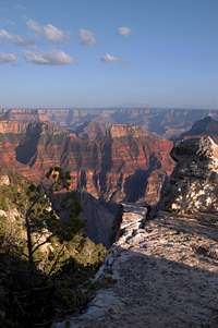
Overview

The foot bridge over the Colorodo River
If you love a great hike, the first look across the canyon will be dangerous, when you see one rim from the other, your mind will trace the route, you will know, you have to do this hike.
Words can't do it justice, even the best photos are a cliché. You have to be there, you have to touch it. If you love this canyon you must enter it. This hike takes you through this amazing landscape.
Depending on how you link up the trails, the rim-to-rim (R2R) hike is about 24 miles (38 kilometers). The R2R hike is divided roughly into three parts. On each end is the steep hike out of the canyon and the middle third is a more moderate and smoother hike through a side canyon that is spectacular in it's own right. The link of South Kaibab and North Kaibab trail are also part of the Arizona Trail Corridor. A trail system that crosses the entire state in a North-South direction.

This hike across the canyon is sort of a reflected mountain climb. An upside-down climb, stand the typical summit climb on it's head and you get the idea. The downhill is first and the uphill is last. The "peak" (really the lowest part) of this hike is the Colorado River at 2400' in elevation. The ends of the hike are at 8250', and 7260' respectively for the North and South Rims.
The temperatures are much hotter at the river, often exceeding 100 degrees F (38 C). When you reach the river, that's only half of the way, you still have to hike out. It's all uphill after you reach the river. Unlike a remote peak, at the river is a store, ranch, a campground, mule wranglers, cabins, shade and water.
This is a very popular hike and there will be lots of people on the trail. We saw several R2R runners. Most people will camp along the route and break this hike into more than one day, backcountry permits are required for any overnighting.
If you can move extraordinarily fast you can day hike R2R. But once you reach the other side you still have to get back. It is a very long 215 mile drive from rim-to-rim so setting up vehicles on both sides is hard. You can catch a ride with TransCanyon Shuttle. Or maybe you can get two groups starting from opposite sides and swap keys in the middle. If you really love hiking, you can turn around and hike back completing an R2R2R trek.
Many hikers go R2R in one day, stay at the North Rim Lodge or a motel on the South Rim and catch a ride back on the shuttle the next day. That way you don't have to carry any camping gear. Even though in the warmer months you will see lots of other folks while on this hike, this trip is definitely worth the price of admission. If you really must be alone bring your crampons and go mid-winter. But no matter how you do it, you will never forget it.
Getting There
Grand Canyon vicinity
 |
 |
 |
 |
The South RimGetting to the South Rim is much closer and easier for most people. The South Rim is open 7-24 365 days a year. The South Rim is lower and gets less snow. Traveling by road from the North Rim to the South Rim requires a five-hour drive of 212 miles (341 km).Road distancesTo the South Rim from:
The North RimThe facilities at the North Rim are closed for the winter in mid October and reopen in mid May. There is no public transportation to the North Rim other than the Trans Canyon Shuttle (928-638-2820). The shuttle will take you from the South Rim to the North Rim or the other way for $75 as of May 2008.Road distancesTo the North Rim from:
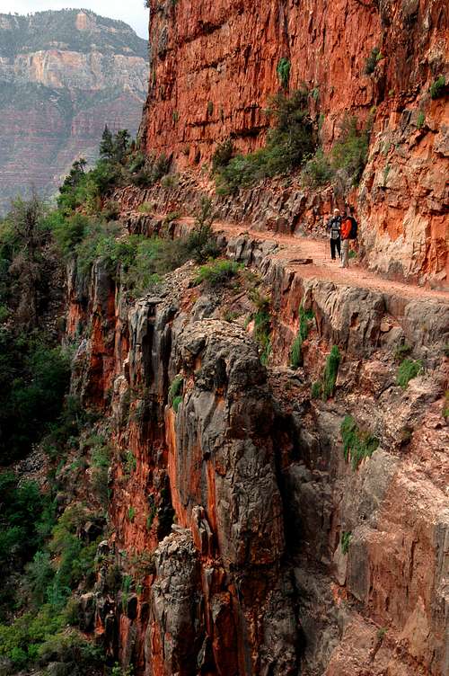
Trail headsYou can start hiking at either the North Rim or the South Rim. If you are starting on the South Rim you have two main choices, the Bright Angel Trail, or the South Kiabab Trail, there are other possibilities but those are the main two trails heads for the cross canyon trek. Bright Angel is longer, but not as steep. This is a very popular trail and there can be lots of hikers and mules on this trail. If you are looking for solitude don't go on Bright Angel. On the North Rim the mail trail head is the North Kiabab. |
R2R
Day Hiking

Bright Angel Creek runs along the North Kaibab trail from the pump house residence above Cottonwood down to Phantom Ranch
From Rim to Rim in a day, is a very tough hike. This one is only for the strongest of hikers. Depending on which trail you take this is 24.3 miles (38.9 kilometers) for Bright Angel and North Kaibab link-up or 21.4 miles (34.2 k) if you link South and North Kaibab. If you walk from the North Kaibab trail head to the North Rim campground you can add another 1.5 miles (2.4 k).

Water is available at many locations along the hike. If you are hiking R2R in a day, you can go without camping gear, you can hike across, stay in a motel, and catch the shuttle back the next morning. That is a very popular way to do the hike. Extreme mountaineering? No. Doing the hike in this way is more like a very civilized and comfortable vacation after a long hike, but it works well and anytime you hike 25 miles in a day, you can pat your self on the back. Carrying less water makes the hike much easier but use caution it can be extremely hot and exposed in the canyon. In certain times and locations you can go for miles on these trails with no shade, no water and high temperatures.
Now that the requisite scolding and warning is done, I highly recommend going fast and light. I did the South to North hike with friends, we are very fast hikers, we went light and it took us 11.5 hours. The return trip North to South took 13.5 hours (we were sore on the return). The park service has some free maps available but they are not very good.
Lodging
See the SP Grand Canyon Main page for lodging information on the rims.
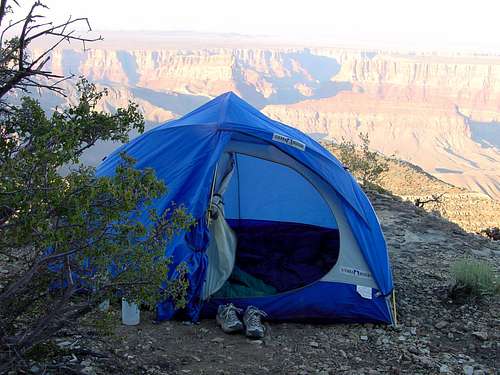
Camping
If you spend the night in the canyon you must have a back country permit. Back country permits are available here. There are Campgrounds at Indian Gardens, Bright Angel (Colorado River), and Cottonwood. These three campgrounds don't really look like backcountry camping at all. Bathrooms, water, numbered camp sites, people, don't expect the quiet solitude that backcountry camping usually implies. There is a complicated set of rules for use of these campgrounds, read the fine print.
There is a nice developed campground on the North Rim. Check the SP Grand Canyon Main Page for information on all of the camping areas in the park. It has lots of good info and links and is a very valuable resource.
Water and Camping Locations
Here is a list of all of the reliable drinking water locations on the main trails and the distance to the water sources from the trail head, none of these need to be filtered unless noted (some of the higher altitude locations are not available in winter). Camping site mileages are also included. There is reliable water in Bright Angel Creek from near the pumphouse residence (at 5.5mi/8.8k from North Kaibab trail head) all the way down to Bright Angel Campground.
| Bright Angel Trail | trail distance | elevation | toilet | camping |
|---|---|---|---|---|
| trail head | 6890'/2091m | yes | nearby | |
| 1.5 mile resthouse* | 1.5mi/2.4k | 5720'/1743m | yes | no |
| 3 mile resthouse* | 3mi/2.8k | 4720'/1439m | yes | no |
| Indian Gardens | 4.6mi/7.4k | 3800'/1158m | yes | yes |
| River trail jnct** | 7.7mi/12.4k | 2440'/744m | yes | no |
| Bright Angel campground | 9.3mi/14.9k | 2400'/732m | yes | yes |
| Phantom Ranch | 9.8mi/15.7k | 2560'/780m | yes | cabins |
*water available May through Sept
** water in river only, should be filtered
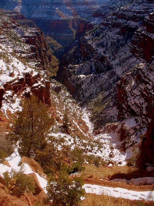
The North Kaibab trail
| South Kaibab Trail | trail distance | elevation | toilet | camping |
|---|---|---|---|---|
| trail head | 7260'/2213m | nearby | ||
| Bright Angel campground | 6.4mi/10.3k | 2400'/732m | yes | yes |
| Phantom Ranch | 6.9mi/11.1k | 2560'/780m | yes | cabins |
| North Kaibab Trail | trail distance | elevation | toilet | camping |
|---|---|---|---|---|
| trail head* | 8421'/2512m | 1.5mi/2.4k | ||
| Supai Tunnel* | 2mi/3.2k | 6800'/2073m | yes | no |
| Roaring Springs** | 4.7mi/7.6k | 5200'/1585m | no | no |
| Pumphouse Residence | 5.5mi/8.8k | 4537'/1382m | yes | yes |
| Cottonwood | 6.9mi/11.1k | 4000'/1219m | yes | yes |
| Phantom Ranch | 14mi/22.5k | 2560'/780m | yes | cabins |
| Bright Angel campground | 14.5mi/23.3k | 2400'/732m | yes | yes |
*water available May through Sept
**Roaring Springs is a 1 mile detour off of the trail
R2R2R
We did this hike on Memorial Day weekend 2008. This is a very difficult hike to do in two days. We went South to North on day one, took a day off on the North Rim and the came back North to south on the third day. For the fittist of extreme runners it is possible to go R2R2R in one day. Check out this trip report of a one day round trip.
To give you an idea of travel time here is our times at waypoints on the R2R2R hike. We were traveling light and moving fast. We did a much better job of logging times on the return trip, and because we were sore from the first leg of the trip we were moving noticeably slower.
The spectacular North Kaibab trail
Example hike times
these times are for fast hiking in very good weather
South to North times
5:15a Leave South Rim
7:15a Indian Gardens
8:45a Colorado River jnct trail
10:45a Phantom Ranch
4:30p North Rim
North to South times
4:20a Leave North Rim Lodge
4:55a North Kaibab Trail head
6:10a Supai Tunnel
6:49a Trail bridge
8:07a Pump house residence
8:50a Cottonwood
12:05p Phantom Ranch
1:53p Colorado River jnct trail
3:15p Indian Gardens
4:44p 1.5 mile House
5:45p South Rim
Weather
When you are going to be on the rims and the inner canyon on the same day you have to be ready for daily temperature swings of 50 degrees F (28 C) or more in good weather. We were extraordinarily lucky, when we went, we had highs in 70's (20's C)in the bottom of the canyon and we saw light snow on the rims. But the week before temps in the inner canyon were exceeding 100 degrees F (38 C). So within a week there were temperature swings from over 100 F to snow. That is difficult to prepare for. See the SP Grand Canyon main page for lots more weather data.
One important note: When it is hot in the inner canyon, going from the South Rim to the North Rim in a day you will go through the hottest part of the canyon much earlier in the day. When going from the North Rim to the South Rim in one day you will hit the hottest part of the canyon in the hottest part of the day.
If you are one of hardened hikers that do this trip in winter, well then, there is nothing I can say that you don't already know.
Trail from Supai to Redwall, I love this photo! The snow delineates the trail very well. The snow on the footbridge brings it into focus, as it bridges from the sunny to the shaded side of the canyon. When I look at the footprints I can feel a cold breeze. Photo by MOCKBA
National Park Service official forcast
another good current forcast
Elevation profile
 The elevation profile from the South Rim to the North Rim. This is Bright Angel Trail linking with North Kiabab Trail. This was information extracted from the gps we carried
Other Resources
Grand Canyon Hiker site
Grand Canyon Treks