
-
 4504 Hits
-
 78.27% Score
-
 9 Votes
|
|
Mountain/Rock |
|---|---|
|
|
47.27410°N / 10.48894°E |
|
|
Hiking, Mountaineering |
|
|
Summer, Fall |
|
|
7799 ft / 2377 m |
|
|
Overview
 Karlespitze as seen from Zwickspitzen (15-08-2009)
As an immediate neighbouring summit of Wannenspitze, Karlespitze, too, belongs to the lonely peaks of Lechtal mountains apart of the main routes.
A short rock ridge and some 20 minutes of easy rock scramble is connecting the some meters higher Karlespitze with Wannenspitze. The short route is marked with red dots so you will not go astray.
Karlespitze, as Wannenspitze, stands south of the village of Häselgehr and is limited to the north by the Lechtal valley, to the east by Gramais valley and to the west by Griesbach valley. Häselgehr, Gramais and Griesbach are the main trailheads for this mountain. To the south Karlespitze is connected to the beautiful Schafkar region, west of the mountain village of Gramais, by a long ridge, which can be used for the traverse to Zwickspitzen.
To climb Karlespitze means: narrow, steep and barely maintained trails, a quite strenuous day hike, pure nature, loneliness, a summit for your own with a nice view and the chance for a even nicer traverse to Wannenspitze and / or Zwickspitzen. In short: a more than satisfying day.
Getting There
 Karlespitze as seen from Wannenspitze (15-08-2009)
The main trailheads for Karlespitze are Gramais in the Gramaiser valley, Häselgehr or Griesau in the Lechtal valley.
You reach Lechtal valley
Follow Lechtal valley road number 198 from Reutte or from Lech / Warth until you reach Häselgehr or Griesau.
The trailhead is at the Häselgehr church on the orographic left side of Lech river.
At Griesau follow the road through the houses until you reach the chapel of Sankt Sebastian. There is a parking area.
The village of Gramais can be reached directly from Häselgehr by using the signposted mountain road up the Gramaiser valley. The trailhead is directly at the little village or behind a chapel some 500 meters before you reach the village. Parking space is very limited.
Red Tape
No red tape as far as I know.  |
Main Routes Overview
 Lonely trees near Karlespitze (15-08-2009)
Griesau / Häselgehr routes
From Griesau or Häselgehr you have to climb Wannenspitze forst. See the "Mein Routes Overview" section how to get to Wannenspitze.
From Wannenspitze follow the south ridge to the nearby Karlespitze on the west side; narrow path, marked with red dots. Where the path tarverses the not very prominent west ridge of Karlespitze leave the path up to the left and climb Karlespitze off-trail in some minutes.
Griesau direct route
From Griesau follow the forest road into Griesbach valley up to Griesbach Alpe, a nice mountain inn. There is a marked shortcut – a steep trail – wich cuts of the first switchback of the mountain road.
From Griesbach Alpe follow the forest road into the lower parts of Seebles Kar. At the end of the road ascent steeply the meadows amidst the forest on a small and partly marked path. This path sometimes disappears completely so orientation can be a real adventure. You must reach the meadow ridge west of Zwickspitzen. On the ridge the path reappears (some red marks and some wooden signs) and traverses the west slopes of Zwickspitzen to Wieslesjoch.
From Wieslejoch follow the steep and marked path up the south ridge to Karlespitze.
Gramais Route
From Gramais follow the northern trail in the direction of Schafkar. Where it crosses the creek for the second time leave the trail and follow an old and narrow path up the valley in direction of Gampensattel.
At about 2000 m traverse to the north (right) over steep meadows up to Wieslesjoch between Karlespitze and Zwickspitzen. From Wieslejoch follow the steep and marked path up the south ridge to Karlespitze. Difficult, partly off-trail route !
Accomodations
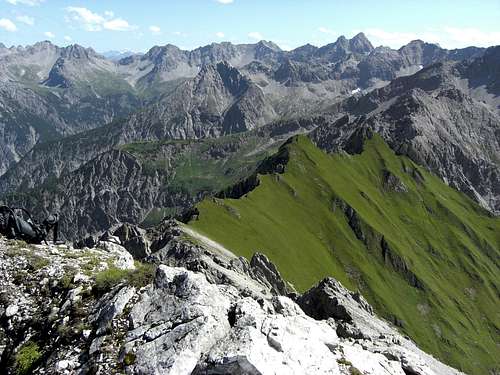 Summit view from Karlespitze to the south and southeast (15-08-2009)
In Lechtal valley there are all sorts of accomodations: Hotels, Inns, private Bed & Breakfast and Camping areas.
For general infomations please refer to: Lechtal tourist page
More detailed informations about accommodations in the nearest villages can be found on the homepages of
Gear & Mountain Conditions
Karlespitze is a summer and autumn hike. As far as I know there are no winter and spring ski hike activities. It is a strenuous day hike from the valley trailheads or as one of several summits during the Wannenspitze – Karlespitze – Zwickspitzen traverse.You need normal hiking gear with good shoes. There is some easy rock scramble near the summit and some exposed traverses on narrow and steep (meadow) trails.
Check the current weather here.