

-
 122611 Hits
-
 97.47% Score
-
 69 Votes
|
|
Mountain/Rock |
|---|---|
|
|
47.55000°N / 12.92000°E |
|
|
8900 ft / 2713 m |
|
|
Overview

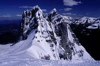
From Berchtesgaden

The East wall
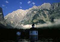
From St. Bartholomea

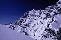
The W face above Wimbachtal
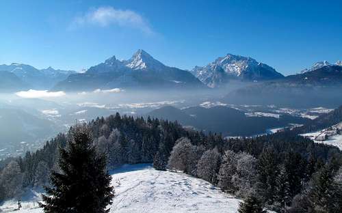
At 2713m Grosser Watzmann is the highest peak standing entirely within Germany. Looming almost 2000 meters above the green waters of Koenigsee, Watzmann's graceful mass provides a postcard-perfect backdrop to the city of Berchtesgaden, in Bavaria's southeastern corner.
Take a look to the webcam below on this page with view directly on "King Watzmann". It's situated over Berchtesgaden (you see the village in foreground) on Kneifelspitze. This is a little, low summit with excellent view over the valley, at Watzmann and Steinernes Meer. The webcam is updated all 30 minutes (only during the time of daylight;-) - the time is local CET (in summer CEST).
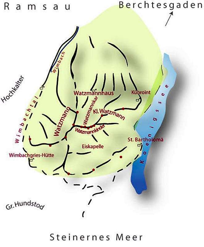
The german part of the Alps is not very large. Among the German summits Watzmann is one of the most important mountains; impressive from all sides. But from each side the character is quite different: from N it is the classical shape, from S a steep and prominent tower. Due to the configuration from E and W Watzmann looks like an enormous, expanded wall. It is not a solitary summit but a ridge of about 3 km length with 3 tent-shaped elevations![]() N-summit (Hocheck 2651 m
N-summit (Hocheck 2651 m![]() Middle (and highest)summit (Mittelspitze 2713 m)
Middle (and highest)summit (Mittelspitze 2713 m)![]() S-summit (Suedspitze 2712 m - in former times also called Schoenfeldspitze).
S-summit (Suedspitze 2712 m - in former times also called Schoenfeldspitze).
Climbing is easy from N over moderately steep slopes and good paths up to Hocheck. From S there is a steep footpath with partially easy climbing (UIAA I) from Wimbachgries to the S-summit, which is scenic because of its spectacular and wide view.
From E lead the celebrated climbs through the Watzmann-Ostwand, the E-face of the south summit, which is one of the highest rock walls in the whole Alps (the old name is Bartholomäwand). But also the northern part of the E-face (less famous) offers fine climbs, primarily the Wiederroute.
The W-side of this mountain is titanic, amorphous but in most parts passable. It is, however, not recommendable to climb because of difficulties of orientation, vast quantities of scree and the absence of interesting climbing problems.
It's almost not worth mentioning, that the view from the summit is the best panorama of the whole area: all surrounding mountains are visible, valleys, woods, lakes and villages are located deep below you. It's simply staggering. ...
But Watzmann is more than a brilliant summit: the surrounding massif of slightly lower mountains is very beautiful to climb: Kleiner Watzmann ("Watzmann's wife" 2307 m/7568 ft), 5 (of the 7) "children" - see the Watzmann legend! - belong directly to the Watzmann massif. Hirschwiese (2114 m) and Grosser Hachelkopf (2065 m) are wonderful summits of an inferior crest, the first often visited, the second hardly ever.
Also an other side crest in SW ( Griesspitze 2255 m) is practically never trodden.
The Watzmann Group has opportunities for everyone: the hiker, the "serious" mountaineer, the climber and the ski mountaineer - all get their money worth! Grosser Watzmann is indeed not a lonely mountain but really a worthwhile summit. All the other noted summits and corners of this great region are rather backcountry.
History
Watzmann rising high above Berchtesgaden
Grosser Watzmann (N-summit =Hocheck) has been visited long time ago through locals, also other parts of the Watzmann massif, mostly within the hunt.
Here some interesting facts to touristical ascensions:
- First ascent of Hocheck (recorded) in 1784 by botanist G. A. Weitzenbach.
- First ascent of Mittelspitze in 1799 (or 1800) by Valentin Stanic, chaplain of Salzburg via Hocheck.
- First ascent of S-summit (Suedspitze) 1832 by P. C. Thurwieser.
- First winter ascent by Johann Ilsanker ('Stanzl') with a partner 1.2.1871.
- First complete traverse of the summit ridge was made in 1868 by A. Kaindl, J. Punz ("Preiss"), and J. Grill ('Kederbacher').
- First solo+winter+night ascent of the Salzburger Weg (UIAA IV+/A0) through East Face Herman Buhl on Feb. 28-March 1, 1953. Hard to believe: this climb was done by moonlight, as a training climb for Nanga Parbat …
Ostwand was climbed in its northernmost part in 1868. True first ascent however was made in 1881 as Johann Grill ('Kederbacher') succeeded to climb from Eiskapelle to the South Summit. Kederbacher (1835-1917) was the first authorised mountain guide in Germany. He studied the face with a telescope from Gotzenalm and found a route through the giant-wall using the huge rock bands in the heart of the wall. Today Kederbacherweg is one of the favored climbs through the E-face. Later he was over 22 years the first maintainer of Watzmannhaus hut.
During the fourth ascent of Ostwand (1890), the first fatal accident took place as Ch. Schöllhorn fell 50 meters into the moat of the big firn field in the lower part of E-face. The point of accident is from that time later known as Schöllhornplatte. After the accident guides were officially forbidden to climb on Ostwand. The forbid was in force until 1909. From then on over 100 people have died on this part of the mountain.
Nowadays Ostwand is not considered technically extremely difficult in climbers standards. The mere scale of the wall however makes it challenge enough for most climbers.
In the following years they found several climbing routes in this mountains, partially difficult and hard climbs. Not until 1947 - many difficult and extreme climbs in the Berchtesgaden Alps were known at this time - found J. Aschauer and H. Schuster the easiest "climbing-path" through the big wall: the Berchtesgadener Weg
A Cabin was build on Hocheck in 1898. In the same year some steps were cut in stone and rope protections were placed. Thus Watzmann became one of the first via ferratas in the Alps: the great Ridge traverse through all 3 summits. In the sixties they intended to build a teleferic to Watzmann-Hocheck: this ideas collapsed fortunately - so remained Watzmann (in contrast to Zugspitze) a mountain for hiker and climber.
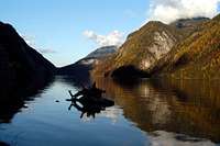 Koenigsee |
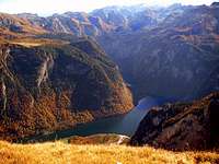 Koenigsee |
 St. Bartholomea |
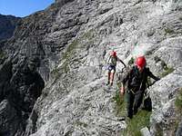
Routes Overview
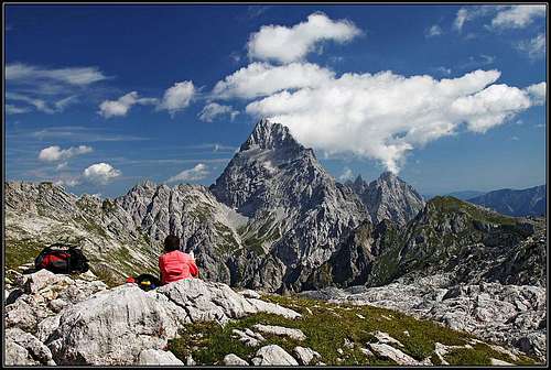
South summit
Mittelspitze from Hocheck
At Grosser Watzmann and the whole Watzmann Group lead numerous interesting routes. Here would be mentioned only the most important of them. Details for all routes you'll find in the AV-Führer Berchtesgadener Alpen (see below).
Grosser Watzmann
Good hikers:![]() Normal ascent from Wimbachbruecke or Hinterschoenau to Hocheck via Falzalm, Watzmannhaus (5 - 6 h)
Normal ascent from Wimbachbruecke or Hinterschoenau to Hocheck via Falzalm, Watzmannhaus (5 - 6 h)![]() Traverse of the summit ridge with three summits Hocheck - Mittelspitze - S-Spitze (~ 2 h)
Traverse of the summit ridge with three summits Hocheck - Mittelspitze - S-Spitze (~ 2 h)![]() Normal descent (ascent is possible but not recommended) from S-summit to Wimbachgries (Wimbachgrieshuette) (2.5 - 4 h)
Normal descent (ascent is possible but not recommended) from S-summit to Wimbachgries (Wimbachgrieshuette) (2.5 - 4 h)
These 3 joined are the well recommended, wonderful and great Watzmann-Ueberschreitung (ridge traverse). It's marked, partially a footpath, very long (12 - 14 h from Wimbachbruecke to Wimbachbruecke - recommended overnight stay in Watzmannhaus). These routes are the only one on Grosser Watzmann for non-climbers. But you must be a safe hiker and free from giddiness, there are short climbs UIAA I-II.
Climbers:![]() Wieder-Route
Wieder-Route![]() Watzmann Ostwand (E-face): most famous a) Berchtesgadener Weg (80 m UIAA III, mostly II and easier) and b) Kederbacher Weg (20 m UIAA IV-, otherwise II - III). There are some other (and harder) routes through the E-face (e.g. Salzburger Weg, Muenchner Weg, Frankfurter Weg, details see climbing guides). The celebrated and dreaded Big-wall has his difficulties not in technical requests but in orientation, the mere scale and objective dangers like rockfall, unexpected weather change and such events.
Watzmann Ostwand (E-face): most famous a) Berchtesgadener Weg (80 m UIAA III, mostly II and easier) and b) Kederbacher Weg (20 m UIAA IV-, otherwise II - III). There are some other (and harder) routes through the E-face (e.g. Salzburger Weg, Muenchner Weg, Frankfurter Weg, details see climbing guides). The celebrated and dreaded Big-wall has his difficulties not in technical requests but in orientation, the mere scale and objective dangers like rockfall, unexpected weather change and such events.
Furthermore there are some interesting climbs in the E-face of Hocheck, worthwhile for very experienced climbers is also the long S-ridge (Schoenfeldschneid) with UIAA IV (with all gendarmes), otherwise II-III (2 km, 700 m).
Kleiner Watzmann
Kleiner Watzmann
Kleiner Watzmann (2307 m/7568 ft)
This shaped summit is more climbing dedicated than his great brother. And he is much more lonesome! Although he has 2 "normal-routes":![]() N-ridge: a short step UIAA II: the aerial "Gendarm", otherwise steep walking terrain - marked with little yellow points. Very nice! - and
N-ridge: a short step UIAA II: the aerial "Gendarm", otherwise steep walking terrain - marked with little yellow points. Very nice! - and![]() E-ridge with passage UIAA II and much steep grass slopes and easy rocks. Both together are the Kleiner Watzmann traverse, a really wonderful route for experienced hikers.
E-ridge with passage UIAA II and much steep grass slopes and easy rocks. Both together are the Kleiner Watzmann traverse, a really wonderful route for experienced hikers.
Furthermore worth mentioning:![]() S-face ("Griachbandl" - a ledge through a wall one must crawl on all fours)
S-face ("Griachbandl" - a ledge through a wall one must crawl on all fours)![]() SW-ridge - and the climbing paradise
SW-ridge - and the climbing paradise![]() W-face: at least a dozen of superfine climbs, the easiest (Alte Westwand) UIAA III+, the other V - VII.
W-face: at least a dozen of superfine climbs, the easiest (Alte Westwand) UIAA III+, the other V - VII.

Watzmannkar
The 5 Watzmann-"Children"
Here you find wonderful hikes and climbs:![]() Child 1: Easy climb (UIAA I) through the Watzmann-Kar (cirque or coomb between Grosser and Kleiner Watzmann) and via Watzmann-Scharte (see SW-ridge)
Child 1: Easy climb (UIAA I) through the Watzmann-Kar (cirque or coomb between Grosser and Kleiner Watzmann) and via Watzmann-Scharte (see SW-ridge)![]() Child 2: W-ridge UIAA III- from the upper Watzmann-Kar
Child 2: W-ridge UIAA III- from the upper Watzmann-Kar![]() Child 3: A nice hike or skitrip
Child 3: A nice hike or skitrip![]() Child 4 (Watzmann-Jungfrau, the "virgin"):Easy climb from E-side or ambitious climbs from W
Child 4 (Watzmann-Jungfrau, the "virgin"):Easy climb from E-side or ambitious climbs from W![]() Child 5: A fine skitrip
Child 5: A fine skitrip
Other rises in Watzmann-Group
Worthwhile in first line Hirschwiese(2114 m) with terrific view at Watzmann S-face. A long but easy hike through Wimbachtal (about 4 h from Wimbachbruecke) and Mooslahnerkopf (1815 m), last elevation in the E-ridge of Kleiner Watzmann: wonderful view to the Koenigsse deep under the nice summit (1 h form Kuehroint-Alm).
Getting There
First, make your way to Berchtesgaden (Upper Bavaria). This little town, lies approximately 150 km in direction south-east from Munich and 25 km in direction south-west of Salzburg, Austria. You can reach it by car (click for directions) or very good by bus (RVO-bus from Salzburg) or by railway . Now you have several possibilities:
- From Berchtesgaden go west by car (8 km direction Ramsau) and turn left into the parking area and trailhead at Wimbachbrueke. Parking will run you 2.50 EUR per day. You can use also the bus (RVO) from Berchtesgaden (railway-station) to Wimbachbruecke (about 2.50 EUR). From here you can go in about 2 hours to Wimbachgries Hut or in 3-4 hours to Watzmannhaus (all marked and signposted)
- Another possibility is starting at Koenigssee (RVO-bus from Berchtesgaden or by car. There is a big parking area, you pay about 3 EUR/day and can visit the world-famous Koenigssee). From here it is a nice hike in 3 hours to Kuehroint Hut. From here you can hike a nice path to Watzmannhaus and Watzmann. This (private) hut is also the best starting point for Kleiner Watzmann, Watzmann-Kar and Watzmann "children".
- If you want to climb the celebrated E-face (Watzmann-Ostwand), you go by ship from Koenigssee to St.Bartholomae (timetable) (about 30 minutes, 6.50 EUR) and start from there (E-face hut/Ostwandlager) mostly very early in the morning.
Red Tape
No fees or other red tape exist per se, apart from the hut fee (about 15 - 20 EUR, cheaper for alpine club members) and parking fee (about 2.50 - 3.00 EUR/day - you can pay up to 7 days in advance).
The whole Watzmann region lies in the Berchtesgaden National Park, there are certain restrictions given by the park rules.
When To Climb
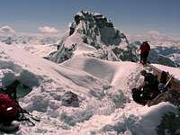
East face in winter
Climbing the East face
You can Grosser Watzmann climb the whole year! In Winter it is an interesting (but not to easy) ski trip, in spring and autumn you must look at the conditions concerning the snow situation. Best climbed for hikers and rock climbers is Juli through September, in some years also October.
Kleiner Watzmann ("Watzmann's wife") you climb normally only in summer and autumn. But Watzmannkar (the great cirque between the summits and some of the Watzmann "children" (No.3 and 5) you can reach very good and worthwhile in winter and spring with skis. But you may not underestimate the avalanche risk in this steep and terrific terrain!
Camping & Huts
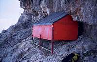
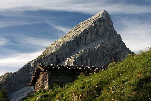
The bivouac in the E face

The cabin below the E wall
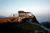
Watzmann Haus

Watzmann Haus
Watzmann is situated in the National Park Berchtesgaden. Here camping is in principle not allowed. Good camping areas, a youth hostel and a lot of hotels and private rooms you'll find in the valley of Berchtesgaden:
Camping Simonhof
D-83486 Ramsau
Tel. und Fax: +43 86 57-2 84
Campingplatz Allweglehen
D-83471 Berchtesgaden
Telefon: ++49 86 52-23 96
Fax: ++49 86 52-6 35 03
Campingplatz Winkl-Landthal
D-83483 Bischofswiesen
Tel.: ++49 86 52-81 64
Fax: ++49 86 52-97 98 31
E-Mail: Camping-Winkl@t-online.de
Camping Grafenlehen
D-83471 Schönau a. Königssee
Tel.: ++49 86 52-41 40
Fax: ++49 86 52-69 07 68
E-mail: Camping-Grafenlehen@t-online.de
Jugendherberge Berchtesgaden / Youth hostel
83489 Strub
Tel: ++49 8652/94370
Fax: ++49 8652/943737
General Informations, adresses and booking possibilities for rooms and hotels you find here: www.berchtesgaden.com
Otherwise you have good possibilities to stay in the huts:
- Watzmannhaus
- Kuehroint Hut
- Wimbachgries Hut (D-83486 Ramsau
Tel.+Fax.-Nr. +49 / 8657 / 344 )
Weather and WebCams
 WebCams and other area information (weather, lodging, events) can be found through the webpage www.wetter-berchtesgaden.com.
At the left side you see a webcam situated over Berchtesgaden on Kneifelspitze. This is a little, low summit with excellent view over the valley, at Watzmann and Steinernes Meer. The webcam is updated all 30 minutes (only during the time of daylight;-)
German-language Books
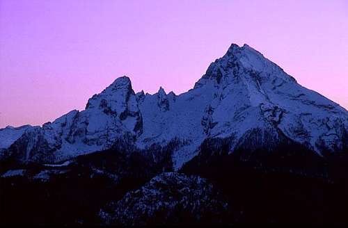
Watzmann in afterglow
As SP's Books page does not allow entry of books outside of Amazon.com's US site, and there are very few English-language books on the Watzmann, here are links to some recommended readings by SP member Ari and guenni:
Books:
- AV-Führer Berchtesgadener Alpen, Bergverlag Rudolf Rother, 1994. ISBN: 3763311270
- Die Schönsten Hochtouren um Berchtesgaden. Verlag Plenk, Berchtesgaden 1997. ISBN: 3-927957-05-4
- Rasp Franz: Watzmann-Ostwand - Ein Führer für die Begeher der klassischen Routen der Ostwand. Bergverlag Rudolf Rother, 2nd edition 1990. ISBN 3-7633-4141-2
- Watzmann. Mythos und wilder Berg, Horst Höfler, Heinz Zembsch, 2001. ISBN: 3905111616
Comments from SP Member guenni: Illuminates the huge mountain from all sides. Recommendable. Horst Höfler is a well-known mountain photographer. Heinz Zembsch is leader of the "Erste Bergschule Berchtesgadener Land".
- Ein Watzmann-Ostwand-Buch. 7th edition, Verlag Anton Plenk KG, 1981. ISBN: 3-922590-05-5
Comments from SP Member guenni: Exhausting presentation of the east-face-history. A little bit lofty, but nevertheless worth reading.
Newer editions may be available.
Maps:
- Topographische Karte Nationalpark Berchtesgaden 1:25 000, 20m. Bayerisches Landesvermessungsamt
- Österreichische Karte Nr:93 1:25 000, 20m. Bundesamt für Eich- und Vermessungswesen.
The Watzmann Legend
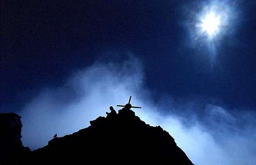
Mystical atmosphere on Watzmann
Interwoven with this moubtain is the saga from the barbarous King Watzmann:
Berchtesgaden's Symbol © by sandysmith. Permission granted by the author for use on SP.
The Watzmann massif has come to be known as the symbol of the Berchtesgaden area due to the following legend:
King Watzmann ruled over Berchtesgaden, he hated humans and animals and loved to torment his subjects and torture their animals. Mad hunting parties were his favorite sport and he loved the sound of the hunting horns and the baying of the hounds resounding throughout the forest. His wife and seven children also shared his lust for wild hunts where the sweating horses collapsed with exhaustion and the game was chased to death before being savagely shredded to bits by the hounds.
This madness continued until God decided to punish them. With cries of ‘Off to the hunt!’ echoing from the castle courtyard and hunting horns resounding, the whole family set off with their baying hounds. In the pale light of dawn, the king noticed an old woman with her grandchild on her lap. He spurred his horse on toward them so as to trample them to death. When the farmer and his wife ran out of the hut to bring their dying loved ones inside, the king called the dogs on them till they were bitten to shreds. Smiling, the king, queen and children observed the bloody scene.
Now here they stand, immortalised in rock: the king, his wife and seven children (one speaks today from five children, because two rocks are to unimposing for been counted from mountaineers M.P.) forced to stare down into Berchtesgadenerland.
External Links
- Steinmandl.de
Route description (ridge traverse) in German - Watzmann Haus Info
DAV page with info on Watzmann Haus - Official Watzmann site
Route information, huts, history etc. A must visit for German speakers. - Klettern im Berchtesgadener Land/Watzmann
- www.watzmann.com
Themes about the mountain range of Berchtesgaden Alps (esp. Watzmann) and the region of "Berchtesgadener Land". - picture gallery of Watzmann ridge traverse (scroll down for english captions!)
- National Parc Berchtesgaden
The official homepage of the german national parc around Watzmann, Hochkalter and Steinernes Meer. - Alpinismus und Klettersteige - Klettersteig Hoher Göll
Via-Ferrata.de - Das Klettersteigportal - Über 100 Klettersteige. Dazu Informationen zum Alpinismus, Bergsteigen und Klettern. - Wimbachgrießhütte Info
DAV page with general info on the Wimbachgrießhütte
Mathias Zehring - Jan 22, 2005 5:14 am - Voted 10/10
Untitled CommentI already posted info about the trip of Hermann Buhl. My source is the biography by Horst Höfler, AS Verlag, Zuerich 2003, where the original trip report of Buhl is printed. And there Buhl wrote that he started on February 28th at 7 pm at St. Bartholomae.
Thank you for the correction that Buhl wasn't the first in winter in the east face.
guenni - Jan 21, 2005 5:30 pm - Voted 10/10
Untitled CommentKederbacher Weg:
First successful winter-mountaineers were Toni Beringer, Simon Flatscher, Ludwig Zankl (all Bad Reichenhall) and Georg Mitterer (Trostberg). Date was 6th to 8th of December 1930.
Salzburger Weg (Route Salzburg):
First climb through "Salzburger Weg" in winter by Bernulf Freiherr von Crailsheim, Thomas Freiberger, Konrad Hollerieth, 8th to 10th of January 1949.
Hermann Buhl from Innsbruck ascended the route called "Salzburger Weg" (UIAA IV+ / A0) solo and in the winter night(!) from 27 th to 28th of February in 1953. It was a training for his first ascend of Nanga Parbat in the Summer of the same year. He didn't know this route from summer.
Münchener Weg (Munich route):
First ascend of "Münchener Weg" in winter: Karl and Fritz Krämer (Frankfurt), Oskar Dorfmann (Regensburg), 28th of March to 1st of April 1949
Berchtesgadener Weg (Berchtesgaden route):
First winter climb: 29th to 31st of March 1949 by Werner Kohn, Reinhard Sander (both Frankfurt).
Source: Hellmut Schöner: Zweitausend Meter Fels. Ein Watzmann-Ostwand-Buch.
7th edition 1981.
Mathias Zehring - Jan 22, 2005 5:14 am - Voted 10/10
Untitled CommentI already posted info about the trip of Hermann Buhl. My source is the biography by Horst Höfler, AS Verlag, Zuerich 2003, where the original trip report of Buhl is printed. And there Buhl wrote that he started on February 28th at 7 pm at St. Bartholomae.
Thank you for the correction that Buhl wasn't the first in winter in the east face.