
|
|
Area/Range |
|---|---|
|
|
36.55680°N / 105.4169°W |
|
|
Hiking, Mountaineering, Scrambling, Skiing |
|
|
Spring, Summer, Fall, Winter |
|
|
11000 ft / 3353 m |
|
|
Overview
Wheeler Peak Wilderness is one of New Mexico's finest alpine wilderness areas, consisting of 19,150 acres of rugged peaks, glacial cirques (minus the glaciers of course), alpine lakes, forests, and tundra. The wilderness area is located within Carson National Forest and surrounds Wheeler Peak (13161'), the highest peak in New Mexico. The wilderness is next to famous Taos Ski Valley. Elevations in the wilderness range from a low of 7650' near its western tip to a high of 13161' at the summit of Wheeler Peak.
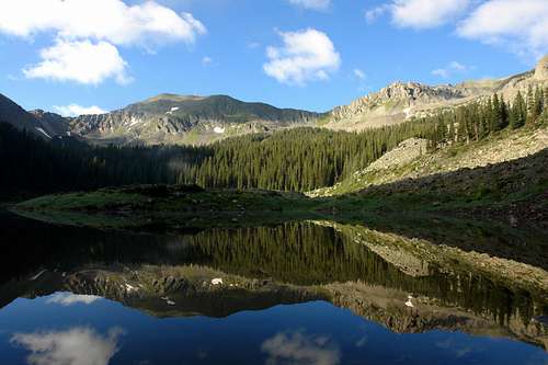 Williams Lake and UN 12819. Photo courtesy of SP user strudolyubov.
This wilderness is a haven for outdoor recreationalists. Maintained hiking trails lead to alpine lakes and peaks (see below and references). If you venture off trail, there are many more peaks to summit and ridges to traverse, including fine class 3 scrambles. Home to a variety of plantlife and wildlife, you may see curious marmots and herds of bighorn sheep if you venture above treeline onto the windswept ridges. Under snow cover, this area is transformed into some of the best backcountry skiing in New Mexico.
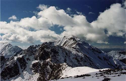 Lake Fork Peak from Kachina Peak after an autumn snowfall.
Wheeler Peak Wilderness was established in 1964 (with the passage of the Wilderness Act). It was significantly enlarged in 1980 (with the passage of Public Law 96-550). In 1996, 764 acres of land south of the ridge between Simpson Peak and Old Mike Peak were transferred to the Taos Pueblo (with the passage of Public Law 104-333).
Access and trailhead information
There are two primary ways to access the four established public trails that penetrate the Wheeler Peak Wilderness: NM 150 from the west, and NM 578 fom the north. The four trails are:
1. Wheeler Peak Trail (#90)
2. Williams Lake Trail (#62)
3. Lost Lake Trail (#91)
4. East Fork Trail (#56).
There are two other public trails within Wheeler Peak Wilderness:
1. Horseshoe Lake Trail (continuation of #91), can be accessed from either the Lost Lake (#91) or East Fork Trails (#56)
2. Sawmill Park Trail (#55), can be accessed via the East Fork Trail (#56).
There are also a multitude of unmaintained "climber's trails" too numerous to list here, for example the steep trail that goes from Williams Lake up to the saddle between Wheeler and Walter.
Directions to Wheeler Peak TH:
Take NM 150 to the Taos Ski Valley parking area. The Wheeler Peak Trail starts near the NE corner of the parking area (~9440').
Directions to Williams Lake TH:
Take NM 150 to the Taos Ski Valley parking area. From the NE corner of the parking area, find and take Twining Rd (dirt road) for about 2 miles to the hikers' parking lot (~10200') which will be on the right side of the road after some switchbacks. This dirt road gets fairly steep, but normal passenger cars will be OK as long as the road is snow/ice free. From the parking lot, follow a well-beaten path heading S from the SW corner of the parking lot. Shortly you will pass the Bavarian Restaurant (good German beers/grub although they are generally closed during the spring and fall "shoulder" seasons) and come to the bottom of a ski lift (Kachina Lift #4). Head up the slope (past the lodge) and turn left at a small shack called Black Diamond Espresso. Hike up a flat ski run for about 5 minutes and reach the start of the Williams Lake Trail. It is about 3/4 mile from here to the wilderness boundary.
Directions to Lost Lake TH:
Access NM 578 from NM 38 just to the SE of Red River. Drive NM 578 for about 6.4 miles until the pavement ends. Turn right onto Forest Road 58 (narrow rocky road) for 1.1 miles to the parking area for the Middle Fork and Lost Lake TH's (~9640').
Directions to East Fork TH:
Access NM 578 from NM 38 just to the SE of Red River. Drive NM 578 for about 6.4 miles until the pavement ends. Turn left onto Forest Road 58A and veer right after crossing a bridge. Follow this rocky road for about 1.2 miles to the parking area for the East Fork TH (~9640'), which has a large map of the trails and a camping area. (Note: You will pass a sign that says "Entering Private Land, Dead End." There is also an iron gate that may appear locked but isn't.)
Peaks and lakes
Wheeler Peak Wilderness contains 8 of the highest 100 ranked peaks in NM. Following is a list of all the named and NM ranked peaks in the wilderness, sorted by elevation (source: Lists of John):
| Peak (by elevation) | Elevation (ft.) | NM rank |
| Wheeler Peak | 13161 | 1 |
| Mount Walter | 13133 | |
| Old Mike Peak | 13113 | |
| Simpson Peak | 12976 | |
| Lake Fork Peak | 12881 | 5 (tie) |
| UN 12819 | 12819 | 9 |
| Red Dome | 12661 | |
| Vallecito Mountain | 12643 | 15 |
| Taos Cone | 12260 | |
| Frazer Mountain | 12163 | |
| South Fork Peak | 11978 | 39 |
| UN 11912 | 11912 | 44 |
| Taos Peak | 11257 | |
| UN 11202 | 11202 | 76 |
| UN 10848 | 10848 | 100 |
| Cuchillo del Medio | 9785 |
Wheeler Peak Wilderness also contains three beautiful major alpine lakes:
| Lake | Elevation (ft.) | Trail access |
| Williams Lake | 11040 | Williams Lake Trail |
| Lost Lake | 11495 | Lost Lake or East Fork Trails |
| Horseshoe Lake | 11950 | Horseshoe Lake Trail (via Lost Lake or East Fork Trails) |
Flora and fauna
under construction; contributions welcome!
Carson National Forest's website has a brief introduction to the flora and fauna of this wilderness area.
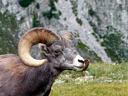 Bighorn sheep are plentiful. Photo submitted by SP user Midlife Mountaineer. Bighorn sheep are plentiful. Photo submitted by SP user Midlife Mountaineer. |
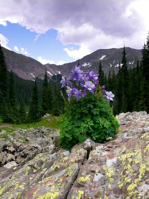 Columbines near Williams Lake. Photo submitted by SP user slowbutsteady. Columbines near Williams Lake. Photo submitted by SP user slowbutsteady. |
Red tape and camping
Wilderness regulations apply: travel is restricted to foot or horseback; no mechanized equipment are allowed. No permits are required for day-hikes nor overnight backpack trips.
Fishing is allowed by permit only. For more information on fishing, please click here.
Camping information
Backcountry camping is allowed, but please follow wilderness camping guidelines. The U.S. Forest Service topo map (Ref. 3 below) marks the locations of some suggested backcountry campsites, mostly in the vicinity of Williams, Lost, and Horseshoe Lakes. There are also quite a few developed campgrounds near the wilderness trailhead access points, summarized in the table below. Click here for a map showing the approximate locations of these campgrounds (#1-9 on the map).
table coming soon...
Campgrounds on NM 150: Lower Hondo, Cuchillo del Medio, and Twining.
Campgrounds on NM 38 (west of NM 578): Fawn Lake, Elephant Rock, and Junebug
References and external links
1. Carson National Forest link for Wheeler Peak Wilderness.
2. Taos Ski Valley.
3. Latir Peak and Wheeler Peak Wildernesses, U. S. Forest Service topo map.
4. Lists of John (lists of peaks).
5. Kathy Kalen, The Hiker's Guide to the Enchanted Circle (1999).