|
|
Area/Range |
|---|---|
|
|
35.00030°N / 109.8001°W |
|
|
Hiking |
|
|
Spring, Summer, Fall, Winter |
|
|
5483 ft / 1671 m |
|
|
Overview
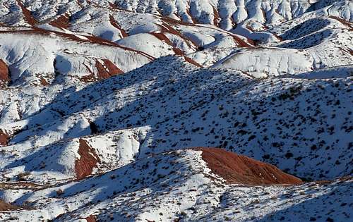
Located in the Northeastern portion of Arizona and full of changing vistas, colorful logs, petroglyphs, mulicolored buttes, ancient ruins, solar calendars and an array of wildlife lie the Painted Desert and Petrified Forest National Park.The Petrified Forest was first designated as a National Park back in 1962 by Congress, but its first protection began around 1906 when President Theodore Roosevelt designated part of the current area as a national monument. The wilderness was further expanded in 1932 when more than 53,000 acres were purchased and added to the monument.
There are numerous short trails that can be hiked easily, as well as historical buildings to visit.
At the visitor’s center you can watch a short (approximately) 20-minute film discussing the history of the park and how it was created.
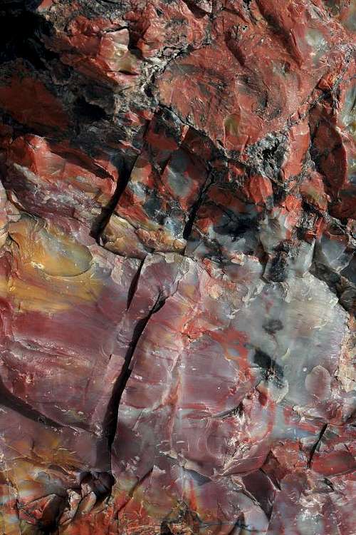
Petrified wood is very heavy and dense. One cubic foot of it may weigh up to 200 pounds and can only be cut with a diamond saw. There are many different colors in some of the petrified wood located in the park. This occurs because of iron, carbon, manganese, cobalt, and chromium that were present in the water when these pieces of wood became petrified.
Getting There
From Phoenix: Take Highway 87 North to Payson, Highway 260 East to Heber, then take Highway 377 North to Holbrook, and Highway 180 South to the park's Southern entrance (Approximately 215 miles).From Albuquerque, New Mexico: Travel West on Interstate 40 for approximately 205 miles until you reach exit 311. Take this exit and follow the signs for the park's North entrance.
From I-40 East: Take exit 285 into Holbrook and then follow Highway 180 South to the park's Southern entrance (Approximately 19 miles after turning onto Highway 180).
TOTAL LENTGH OF NATIONAL PARK IS 28 MILES
Red Tape
ENTRANCE FEESVehicle - $10 (seven-day pass).
America The Beautiful (National Parks and Federal Lands Recreation Annual Pass - $80
Senior "America The Beautiful" Pass (Lifetime) - $10
Golden Age Passes will still be honored for life
Golden Access Passport(blind or disabled) - Free (lifetime).
RESTRICTIONS
DO NOT REMOVE ANY PETRIFIED WOOD FROM THE PARK
No camping without a permit
No offroad vehicle travel, this includes bicycles as well (bicycles however are allowed on the paved roadway, but not on paved trails)
Do not feed the wildlife
Pets must be leashed
Stay on trails
>Do not climb on prehistoric or historic walls
Do not harm or remove any petroglyphs. Direct physical contact with rock art is prohibited
No ground fires allowed (The use of solar, propane, and white gas fuel stoves and charcoal grills are allowed in designated picnic areas) Restrictions my apply during high fire danger
Firearms must be broken down, unloaded, cased, and stored in your vehicle. Carrying or use of firearms in park is prohibited
Safety
Be wary of potential wildlife crossing the roadDo not feed or approach wildlife, this will upset them later on down the road when the next person won't feed them
Cliff edges and some steep slopes may have unstable rock, don't venture too close to the edge unless you want to test the theory
There can be great temperature extremes as well as weather extremes can be present here and include the following:
July-August - Monsoon thunderstorms can be present
October-April - Cold temperatures and snow could be present
May, June, and September - I'm not really sure, the brochure didn't say
Flash Floods and Lightning can also be concerns in the Late Spring/Summer months
Beware of Quicksand in some of the washes
There are yellow emergency phones located at Puerco Pueblo, Blue Mesa, and Crystal Forest parking areas.
Trails Overview
Colorful Petrified Log along Crystal Forest Trail
I will try to list the trails and lookout in order that they will be encountered if arriving from the park's Southern entrance.
Giant Logs Trail - This trail has stairs and is only 0.4 miles long. Enter via the Rainbow Forest Museum shortly after entering the park.
Long Logs Trail - Access this trail to the right hand side shortly after you leave the Rainbow Forest Museum. It is accessed by walking a half mile to the trailhead.This trail contains the park's largest concentration of Petrified Wood and is a 0.6 mile loop trail for a total distance of 1.6 miles.
Agate House Trail - This trail is connected via the Long Logs Trail and is 2 miles round trip. The main attraction on this trail is a partially restored pueblo made from petrified wood. This is one I wish I would have seen.
Crystal Forest Trail - Located about 1/3 of the way through the park on the right hand side. This is an easy 0.8 mile loop trail that contains some very colorful petrified logs.
Jasper Forest Overlook - Located on the left hand side of the road, Jasper Forest overlook gives visitors the chance to see hundreds of petrified logs scattered across the valley below.
Blue Mesa Loop Drive - Blue Mesa loop drive is a must see. It has impressive views of the valley with many colorful formations. It has several spots along the way where you can pull your vehicle over and enjoy the view.
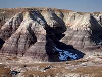
Blue Mesa Overlook
Blue Mesa Loop Trail - Unfortunately this trail was closed when I visited it, but it probably would have been the most scenic trail in the park to visit. It is a one-mile loop trail that is steep and difficult.
The Tepees - Located on the left hand side of the road, the tepees are probably one of the more photographed views in the park. Their colors contain purples, blues and grays.

The Tepees
Newspaper Rock - Located on the left hand side. Hundreds of Petroglyphs are available for viewing on the rocks below. There are 3 spotting scopes positioned to make it possible for an up close view, or you can bring your own binoculars so that you don't have to wait in line if it's busy. If you like petroglyphs than you probably don't want to miss this one.

Newspaper Rock
Puerco Pueblo - This is located on the right hand side of the road and is a very short and easy paved trail with views of a pueblo that is said to have been built around 1250 A.D. At the end of the trail is a view of some more petroglyphs as well as a Solar calendar that marks the Summer Solstice. Hopefully the rangers will be there to explain it to you and to point it out. If they are not there, then look to your left when you get to the end of the trail and see if you can find it. Bathrooms are available here.

Puerco Pueblo
Lacey Point, Whipple Point, Nizhoni Point, Pintado Point and Chinde Point - These lookouts are all located within close proximity to each other and are on the left hand side of the road. They offer great views. Bathrooms are available at Chinde Point.
Rim Trail - An easy one-mile round trip trail that connects Kachina Point and Tawa Point. The trail can be started from either point.
Contact Information
Petrified Forest National ParkP.O. Box 2217
Petrified Forest, AZ 86028-2217
Phone # is: 928-524-6228
http://www.nps.gov/pefo
Email: PEFO_Superintendent@nps.gov
Current Weather


Click the Satellite picture for a video loop of current weather