
|
|
Area/Range |
|---|---|
|
|
56.24068°N / 4.77081°W |
|
|
Hiking, Mountaineering, Sport Climbing, Bouldering, Ice Climbing, Scrambling, Skiing |
|
|
Spring, Summer, Fall, Winter |
|
|
Overview
Arrochar Alps
The mountains located to the north and to the west of Arrochar are some of the most well known and frequented peaks in the Southern Highlands of Scotland. The main peaks of this range are Beinn Narnain, Ben Vane, Beinn Ime, Ben Vorlich and The Cobbler. These five main peaks gave rise to the early development of climbing in Scotland. Originally known as 'The Arrochar Group' or 'The Arrochar Mountains' in the latter 1800's and early 1900's the term 'Arrochar Alps' was only first introduced by the author and climber Ben Humble in 1946.
Of the five main peaks, The Cobbler, undoubtedly is the biggest attraction to the climber(although not in size) . The extraordinary jagged outline of the three rocky peaks, clearly visible from Arrochar itself, it has made the Arrochar Alps the focal point of climbing in the Southern Highlands since the first explorations took place in the late 1800's. In these early days, when there was no cars, Arrochar was easily accessable for the early visitor as it had a train station on the West Highland Railway line.
The Arrochar Alps are enclosed by Loch Lomond to the east, Glen Croe and Loch Long to the south, Glen Kinglass on the west and Strath Duibh-uisge to the north.
As the weather in Scotland is generally a bit on the wet side, care should be taken when in the Arrochar Alps in this kind of weather as the rock is mainly made up of mica-schist with a coating of lime. This is seriously slippy stuff when wet!
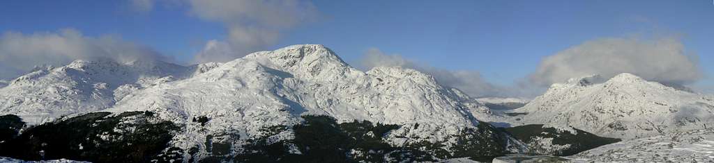
Although not generally noted for its winter climbing, the right conditions can provide excellent snow and ice routes. Unfortunately these conditions do not last long due to the modest height of these peaks. Throw in the proximity to the west coast and you usually don't get prolonged winter conditions compared to other locations in Scotland.
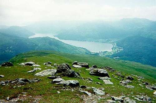
Lying deep in the glen between Ben Vane and Ben Vorlich is the Loch Sloy reservoir. Fed by many of the mountain streams this reservoir feeds the generating station at Inveruglas on the banks of Loch Lomond.
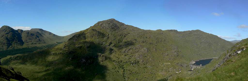 Ben Vane and Loch Sloy from Ben Vorlich. (Photo by Boydie)
Cowal
Directly to the west of the Arrochar Alps sits the district of Cowal. Unfortunately due to this close proximity, the area is sadly by-passed and this is a real shame, for although the peaks here lack in great height they certainly don't lack beauty.
The Argyll National Forest Park in Cowal was opened in 1935 and was created, in part, due to the fine array of trees that can be found within, most notably the spruce, the larch and the Scots pine. Around the afforestation some splendid peaks can be found, with the slopes of Ben Donich and The Brack being amongst the best to be ventured upon. Along with the trees and the mountains the area throws in some of the most beautifully scenic seas and sea lochs to cap it all off. With the Firth of Clyde being it's most western boundary an array of fine lochs such as Fyne, Goil and Eck can be found all the back until reaching the shores of Loch Long on its eastern side.
Access to the peaks in the area is predominantly done from the peaceful little village of Lochgoilhead where the majority of peaks are all within easy walking distance. The small town of Inveraray on the banks of Loch Fyne is another place that is worthy of a visit as it has plenty of attractions such as the castle and the jail. Even if not visiting the area for climbing/hiking the visitor will not be disappointed, as the scenery is in such abundance that a week would not be enough to sample all that it has to offer.
The Main Peaks
Arrochar Alps
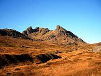
The Cobbler
A splendid peak and most definitely the focal attraction of the range, the Cobbler is a Scottish Corbett. The jagged outline of its three peaks are distinguishable from all around this and its neighbouring ranges and it is the central peak that adorns the name 'Cobbler'. The summit of The Cobbler is made of a large block of rock which is roughly 25 feet high. In order to attain the summit, one must scale this rock, but due to the exposure of doing this, the majority of people are more than happy to remain just beneath it. The other two peaks of the three are 'The Cobbler's Wife' (south peak) and 'The Cobblers Last' (north peak).
Height: 884m
Also known as: Ben Arthur
Pronouncation: As spelt

Beinn Ime
The highest peak in the Arrochar Alps range, Beinn Ime holds a central and commanding position in the area. The peak is a Scottish Munro and a fine bulky hill that can be done in conjunction with many other splendid peaks in the range (i.e, The Cobbler, Beinn Narnain or Ben Vane). The usual ascent is through the pass between the Cobbler and Narnain that leads onto Beinn Ime's southern slopes. The route up is straight forward, although the initial stages tend to be very boggy, before the rocky top sections are reached.
Height: 1011m
Translation: Butter Hill
Pronouncation: byn-eem

Beinn Narnain
Sitting prominently next to The Cobbler and Beinn Ime, Narnain usually finds itself being part of a two/three peak bagging session from its visitors. The peak can be climbed from the south at the Narnain boulders, from its south east ridge via Cruach nam Miseag or from the north west path just before the Bealach a'Mhaim. The first two options are the best as these take in the excellent Spearhead Ridge.
Height: 926m
Translation: Hill of the Notches
Pronouncation: byn-naarnain

Ben Vane
Translated it's called the middle hill and it is the middle hill with Ben Vane taking its place in the centre of the Arrochar range, however should this peak be called something different. The majority of peaks in Scotland that translate into 'middle hill' have the name Beinn Meadhoin and it's believed that the cartographer who recorded the name had no knowledge of the Gaelic language. It's an impressive peak that has a steep southern face that spans over 500m. The best approach is via the peaks south east ridge that is strewn with rocky outcrops. There are a few false summits on route that eventually lead to a small final scramble that climaxes onto the summit plateau.
Height: 915m
Translation: Middle Hill
Pronouncation: byn-vane

Ben Vorlich
This is a great big bulk of a mountain that holds a picturesque location on the western shores of Loch Lomond. Ben Vorlich rises proudly above the small villages of Inveruglas, Ardvorlich and Ardlui. Access routes up onto the peak can be found in both Ardlui and Inveruglas, with the latter giving fine views of the Loch Sloy reservoir.
Height: 943m
Translation: Hill of the Bay
Pronouncation: byn-vorlich

A'Chrois
This small, but fine rocky peak sits proudly at the end of Beinn Narnain's north east ridge and it is via this long delightful ridge that the peak is normally climbed. The best viewpoint of the peak however, is seen from Coiregrogain in the north where the rocky face drops abruptly towards the forest floor.
Height: 849m
Translation: The Cross
Pronouncation: a-kroy
Beinn Luibhean
Lying one and half kilometers from Beinn Ime, Beinn Luibhean is classed as a Corbett, but is somewhat more of an oulier to Ime. It's location just to the east of The Rest and be Thankful makes it on of the best vantage points to view the splendour and beauty of both Cowal and Arrochar.
Height: 858m
Translation: Hill of the Little Plant
Pronouncation: byn-loovan

Stob Coire Creagach
Running parallel with Kinglass water and Glen Kinglass, Stob Coire Creagach and its long high ridge, Binnein an Fhidleir(Fiddlers Peak), dominate the northern side of the glen/A83 road. Any ascent of the peak would be best served with an inclusion of a traverse along this fine ridge.
Height: 817m
Translation: Peak of the Craggy Corrie
Pronouncation: stob corrie crageech
Beinn Bhuidhe
To the north of Loch Fyne lies the most isolated peak in the Cowal and Arrochar Alps range, the Munro Beinn Bhuidhe. Its nearest peak of any magnitude being almost 8km away. The easiest routes of access onto the mountain are via the Glen Fyne and Glen Shira roads, but as vehicles are not allowed unofficial access, a long walk in will be encountered unless the use of mountain bike is at your disposal.
Height: 948m
Translation: Yellow Hill
Pronouncation: byn-vooee
Meall an Fhudair
To the west of Inverarnan and the north eastern extremities of the Arrochar Alps range sits the rounded little hill, Meall an Fhudair. The hill is not of any great note or stature, but still holds the status of Corbett and thus attracts its fair share of visitors. The normal ascent starts from Glen Falloch and passes over the subsidary tops of Troisgeach and Meall nan Coora before reaching its summit.
Height: 764m
Translation: Gunpowder Hill
Pronouncation: mowl an yeetar
Cowal
Beinn an Lochain
To the west of the Rest and Be Thankful and at the northern tip of Glen Croe stands the fine summit of Beinn an Lochain. Having once held the status of Munro, the peak now has the status of Corbett after modern measurement techniques firmly defined its true height. The peak rises sharply on its eastern side above the beautiful little Loch (hence its name) Restil.
Height: 901m
Translation: Hill of the Little Loch
Pronouncation: byn an lochan

The Brack
Directly west of Ardgarten and close to the shores of Loch Long, The Brack is a popular hill that is steep on all sides, none more so, than on its northern side where there is a splendid corrie beneath The Brack's vertical cliffs. There are two general routes of ascent that both begin from Ardgarten. The first, via the Coilessan glen, which leads up onto the south west ridge and the second, via its north east corrie, which leads onto the northern ridge.
Height: 787m
Translation: Speckled hill (possibly)
Pronouncation: As spelt

Ben Donich
To the west of Glen Croe and the Cobbler in the Arrochar Alps sits Ben Donich. There are three usual routes of ascent/descent for this mountain. From Lochgoilhead, from the Rest and Be Thankful and from Ardgarten. The latter two will, in the initial stges, will involve some bustling through thick forest before reaching your intended ridge of ascent. The peak is mainly grassy, with the latter sections providing some extensive crags.
Height: 847m
Translation: Brown Hill
Pronouncation: byn-doneech
Beinn Bhuela
To the west of Loch Goil sits the craggy peak of Beinn Bhuela. The mountain is surrounded by dense forest, but forestry track roads give good access from Lettermay to the east and from Invernoaden to the west. There are a couple of nice lochans close to the ascent/descent routes that are well worthy of stopping off at.
Height: 779m
Translation: Hill of the Ford
Pronouncation: byn-voola
Beinn Mhor
Situated on the western side of the narrow straits of Loch Eck, Beinn Mhor is a seldom frequented peak that rises predominantly above the thick afforestation that surrounds it slopes. It has five ridges eminating from it, with the south easterly ridge giving direct contact with the peak of Clach Bheinn.
Height: 741m
Translation: Big Hill
Pronouncation: byn-voar
Clach Bheinn
Again situated on the western sores of Loch Eck and again seldom frequented, Clach Bheinn has more of a recognisible shape to it and as its name would suggest takes the form of a large stone, especially when viewed from across the loch. The mountain is very craggy and fairly steep on its eastern side.
Height: 643m
Translation: Hill of the Stone
Pronouncation: claach byn
Getting There
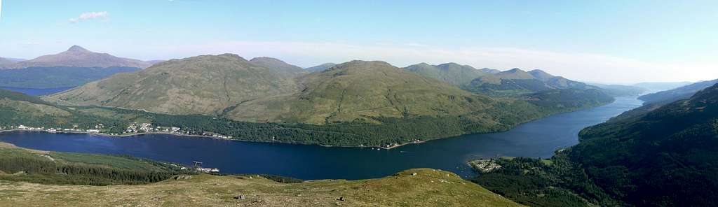
 The Arrochar Alps from Cruach Tairbeirt. (Photo by Boydie)
The best city in Scotland for access to Cowal & Arrochar is Glasgow, however access can be gained from a variety of locations.
Airports
There are a variety of airports throughout Scotland that would provide easy access to Cowal and Arrochar. Below are a selection of the homepages for these airports;
Glasgow Airport
Edinburgh Airport
Prestwick International Airport
Car
From Edinburgh follow the M8 westbound direct to Glasgow.
From Perth/Stirling follow the A9/M80 direct to Glasgow.
From Glasgow take the A82 road via Loch Lomond until reaching Tarbet. Continue along the A82 (this road goes right at Tarbet) for Inveruglas and Ardlui. For Arrochar and Glen Douglas continue straight on at Tarbet (this is the A83 road). To reach the peaks of Cowal, continue through Arrochar and climb The Rest and Be Thankful. At the top, turn left onto the A828 and follow the signs for Lochgoilhead. For the peak of Beinn Bhuidhe in the far north of the range, follow the A83 through Glen Kinglass until reaching the shores of Loch Fyne.
The following link can be used for gaining step by step car directions to Cowal & Arrochar from anywhere in the UK or for variations to the route(s) described above: AA Route Planner
Train
Glasgow Queen Street station direct to Arrochar.
Scotrail info
Bus
Buses run daily from Buchanan Street bus station in Glasgow to Campbell Town, via Arrochar.
Scottish City Link info
Red Tape
Loch Long from the Arrochar Alps. (Photo by Boydie)
There is no red tape in Scotland due to the Land Reform (Scotland) Act 2003 which incorporated the Scottish Outdoor Access Code. This code, which commenced on the 9th of February 2005, has established statutory rights of access to land and inland water for outdoor recreation.
The Land Reform(Scotland) Act 2003
Scottish Outdoor Access Code
The following aspects should be taken into consideration when you are in the Scottish countryside;
- Seek local advice in regard to deer stalking or grouse shooting activities
- Ensure that all gates are closed behind you
- During the lambing season (March to May) ensure that all dogs are kept on a lead
- Please refrain from feeding or annoying any animals
- Limited parking space is available at the start of many routes, please ensure that you are not blocking a road and/or entrance
- Parking is provided at the start of some routes by the local farmers, it is polite to ask if you can use this facility
- Try to refrain from crossing fields with animals and/or crops if an alternative route is available
- Ensure that you treat the local environment with care by leaving it as you found it and by taking any litter home with you
- Any camp fires should be carefully watched and only used away from dense forest areas
Special consideration should be taken into account when planning a trip in the mountains when the deer stalking season is in full flow. See next section for details.
Deer Stalking Information
 |
 |
 |
 |
 |
 |
 |
Deer stalking takes place in Scotland mainly between the months of August and October, although this can continue through until the turn of the year.
The current main stalking dates for Glen Fyne & Glen Falloch for this year are mid August until mid October.
When on the hills during these times walkers can help to avoid disturbing the deer by:
1. Checking with the estate or appropriate Hillphone service.
2. Find out about stalking activities before you go.
3. On the day, follow any advice on locally posted signs about preferred routes.
4. Keep to established tracks where they exist.
5. On the hill, keep to the ridges and avoid cutting through corries especially when descending as this will disturb the deer less.
It should be noted that no deer stalking takes place on Sundays.
Information and contact details for planned deer stalking can be found at Hill Phones, Glen Fyne & Glen Falloch
The main peaks affected in the area are: Beinn Bhuidhe and Ben Vane
Accommodation
There is a large variety of accommodation available within the Cowal and Arrochar Alps district. Below is a selection of this accommodation.
Hotels/B&B's
Tarbet hotel
Colquhoun Arms Hotel
Rowantree Cottage
Hostels/Lodges
Lodge on Loch Lomond
Loch Lomond Youth Hostel
Ardlui Retreat
Campsites
Ardgarten campsite
Beinglas Campsite
Wild Camping
- The larger the group, the harder it is to keep impacts to a minimum. Keep groups small.
- Camp as unobtrusively as possible.
- Remember that noise travels from tents disturbing wildlife as well as humans.
- Enjoy the freedom of wild camping without leaving a trace of your passage. Protect our country's outstanding scenery and wildlife as well as the wilderness experience.
- Camping on the same spot harms vegetation. Aim to move frequently and do not stay for any longer than 3 nights in the same place.
- Lighting fires poses a high fire risk on peaty soils and close to tinder dry grass. A high risk of fire can exist at any time of year, and not just in times of drought.
- Watercourses and loch sides are important sites for birds and animals. Take extra care when camping near burns and lochs, and try to avoid camping immediately beside them.
- Always find a spot at least 30 metres from fresh/running water when going to the toilet.
- Bury excrement in a small hole (not under boulders). A trowel or ice axe can be used to lift a flap of turf.
- Remove all litter (even other peoples!) Think ahead and only carry in what you are prepared to carry out.
The Mountaineering Council of Scotland provides an invaluable leaflet providing a full breakdown of the dos and don'ts of wild camping in Scotland. Wild Camping, A guide to good practice.
Books and Maps
Books
Ski Mountaineering in Scotland by Donald Bennet & Bill Wallace
The Southern Highlands by Donald Bennet
Scottish Hill and Mountain Names by Peter Drummond
The Munros by Cameron McNeish
Climbers guide to Arran, Arrochar and the Southern Highlands by K.V. Crocket & A. Walker
The Scottish Peaks by W.A. Poucher
The Corbetts and Other Scottish Hills by Scott Johnstone, Hamish Brown & Donald Bennet
Cicerone Guide - Central and Southern Scottish Highlands – backpacking guide by Graham Uney
Cicerone Guide - Scotland’s Mountain Ridges - A Guide to Scrambles and Climbs by Dan Bailey
Cicerone Guide - The Munros Vol 1 - Southern, Central and Western Highlands by Steve Kew
Maps
Landranger Map 56 - Loch Lomond & Inverary
OS Map Explorer sheet 363 - Cowal East
OS Map Explorer sheet 364 - Loch Lomond North
Harvey Superwalker Map - Arrochar Alps
Harvey Loch Lomond & Trossachs Satmap SD Card
Mountain & Weather Conditions
Cowal & the Arrochar Alps are fully accessible throughout the entire year however, the weather conditions in the Grampians of Scotland can change rapidly and for that reason you should be fully prepared for all weather eventualities when on the mountains in this area.
West Highlands Mountain Forecast
Avalanche Forecast
Basic Guide to Gaelic


Gaelic is a very rich language topographically, and this basic guide to some of its elements should provide useful information that will assist in understanding how/why the mountains in Scotland are derived and to enrich your knowledge of the local environment. It should be noted that in Gaelic a describing word is placed at the end of a mountain name; i.e. Sgorr (peak) Dhearg (red), Sgorr Dhearg translated is Red Peak. This would read in English as Peak Red.

For a full detail of Gaelic mountain pronunciations I recommend the following book;
• Scottish Hill and Mountain Names; by Peter Drummond.


| Gaelic word | English translation | Pronunciation |
| Achadh | field | achagh |
| Adharcan | Lapwing | ogharkan |
| Airidh | sheiling | aa'rea |
| Allt | stream, river | ault |
| Aonach | ridge | onach |
| Ard, Aird | high place | aird |
| Ba | cattle | baa |
| Ban | white, pale | baan |
| Beag | little | bayk |
| Bealach | pass, col | byalach |
| Beinn, Bheinn, Ben | mountain | byn |
| Beith | Birch | bay |
| Bidean | pinnacle | beetyan |
| Binnean | high, conical hill | beenyan |
| Blar | cleared space, field | blaar |
| Both | Hut | bo |
| Breac | speckled | brechk |
| Buidhe | yellow | booya |
| Cas | steep | cas |
| caorach | sheep | koreech |
| Caorunn | Rowan | koran |
| Carn | cairn | kaarn |
| Ceann | head, headland | kyaan |
| Cioch | breast | keeach |
| Ciche | genetive of cioch | keecha |
| Clach | stone | klach |
| Coille | wood, forest | kilya |
| Creag | crag, rock, cliff | krayk |
| Damh | Stag | dav |
| Darach | Oak | darach |
| Dearg | red | dyerack |
| Dubh | black | doo |
| Eas | waterfall | es |
| Eilidh | Hind | aalay |
| Eilean | island | aalyan |
| Eun | bird | ayn |
| Fada | long | fata |
| Fas | deserted place | faas |
| Feadag | Plover | fedak |
| Fionn | white, holy | fyoon |
| Fraoch | Heather | froch |
| Fuar | cold | fooar |
| Fuaran | Well, spring | fooaran |
| Gabhar | Goat | gaavar |
| Garbh | rough | garv |
| Geal | white | gyal |
| Gearr | short | gyar |
| Githas | Pine | gyoo'as |
| Glas | grey, green | glas |
| Gorm | green, blue | goram |
| Guala | shoulder of hill | gooala |
| Iolaire | Eagle | yi'lara |
| Labhar | loud | lavar |
| Lairig | pass | laarik |
| Leacach | stony slope | lyech-kach |
| Leathad | broad slope, brae | lyehat |
| Liadh | grey | lyeea |
| Madadh-ruadh | Fox | matagh-rooagh |
| Maol | bare top | moel |
| Meall | round top | myowl |
| Mheadhoin | middle | ve-aan |
| Mor, Mhor | large | moar |
| Muileann | mill | mool-an |
| Mullach | top, summit | mooll-ach |
| Odhar | dun coloured | ouar |
| Roid | bog | rot |
| Ruadh | red | rooagh |
| Sgorr, Sgurr | rocky peak | skoor |
| Sneachd | snow | shnyach |
| Sron | nose | srawn |
| Stob | point | stop |
| Tarmachan | Ptarmigan | taramachan |
| Trilleachan | Oyster-catcher, Sand-piper | treel-yachan |
| Uaine | green, pallid | ooanya |
| Uinneag | window | oonyak |
External Links
Visit Scotland
Discover Scotland
Undiscovered Scotland
The Scottish Mountaineering Club
Munro Magic
Hill Phones
The Mountaineering Council of Scotland
Walk Highlands
Arrochar Heritage
Inveraray website
Inveraray Castle
Inveraray Jail