

|
|
Area/Range |
|---|---|
|
|
55.59076°N / 5.25146°W |
|
|
Hiking, Mountaineering, Scrambling |
|
|
Spring, Summer, Fall, Winter |
|
|
2867 ft / 874 m |
|
|
About the Island
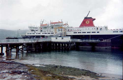
Ferry to the Isle
For the lucky Glaswegians and other locals on the Scottish mainland of North Ayrshire, this beautiful island is just a short voyage from the sea port of Ardrossan in the Firth of Clyde. The Caledonian MacBrayne ferry takes just 55 minutes sailing from there, to reach Arran’s main port at Brodick. There is also another ferry route that links Arran to the Kintyre peninsula in the summer season.
Although the whole island is a largely unspoilt rural paradise (see map below), the interest for mountaineers lies mostly in the north of the island. The geological history of Arran is quite complex but in the central mountainous area of the north the mainly granite structures relate to the Cambrian (oldest) the Tertiary and the Devonian periods as shown in the geology sketch below.
Geography and Geology
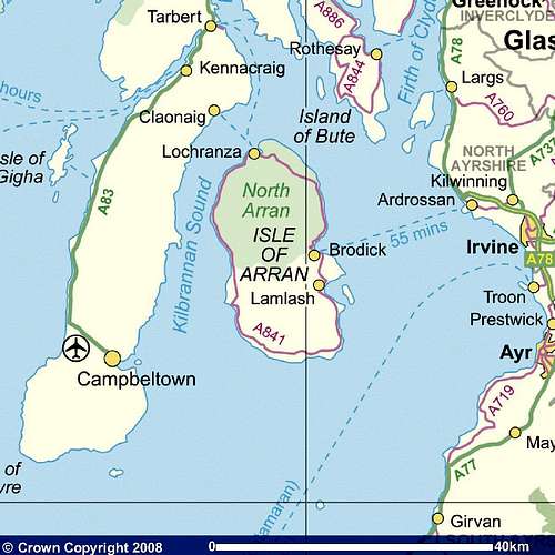
The Isle of Arran
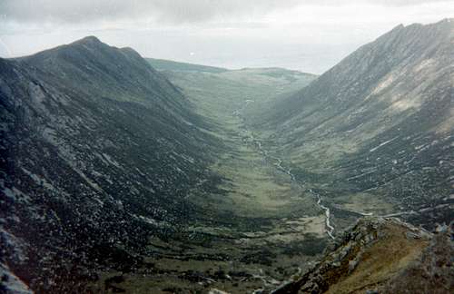
Glen Rosa and its Mountains
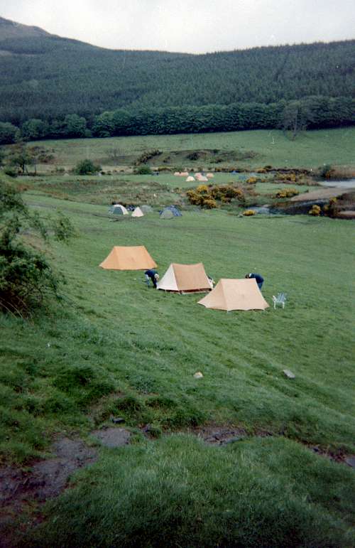
Glen Rosa campsite
The high point of the island is defined by Goat Fell (2868 feet/ 874 metres) which does not quite reach the height needed to make it onto the list of Scottish peaks known as Munros (at least 3000 feet high). However, it makes up for its lack of quantity with plenty of quality as it is surrounded by well defined ridges and holds court over a large number of subsidiary peaks.
From Brodick town, the favoured point of access to these mountains is via Glen Rosa which lies about three miles to the north east of the port. Glen Rosa also has a campsite ideally situated for access to all the main hills that surround the glen.
The campsite is of the no-frills variety so beloved of the hardy outdoor types that choose to stay there in the unspoilt and verdant valley that is free of other forms of habitation.
It pays to be self sufficient when staying in Glen Rosa as there are no shops or hostelries. The nearest pub is in Brodick but it is well worth the walk even if your legs are a bit tired after a day of walking in the hills and glens.
The Ormidale Hotel is your source for nourishing meals and real ales and you can also relax there after a hard day on the hills listening to live music or testing your general knowledge with their pub quizzes.
If you arrive in June, there is also a good chance of partaking in the Folk Festival Folk Festival 2016
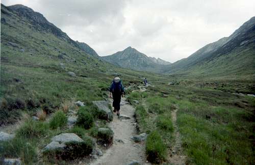
Walking up the Glen
Walking up Glen Rosa is an inspiring introduction to this area of Arran. The empty glen is overlooked on both western and eastern sides by ridges that lead the eye onwards and upwards towards the north and their culmination in the heights of Cir Mhor (798 metres) a pyramidical sight to gladden the eyes all the way up the glen.
The trail splits before the head of the glen and you need to choose to go either left up Fionn Choire or right up onto the saddle that connects Cir Mhor with the lower slopes of the North Goatfell ridge. Either way is just as enjoyable.
The summit ridges are gained by scrambling up the rough granite rocks and are not really serious enough to warrant the use of a rope except in certain areas and generally any difficulties can be avoided by moving along the ridge.
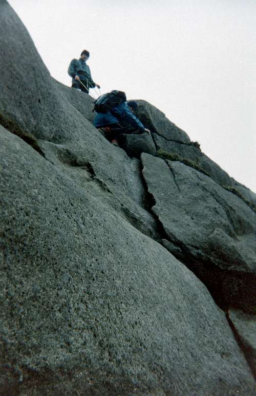
Roping down from the ridge.
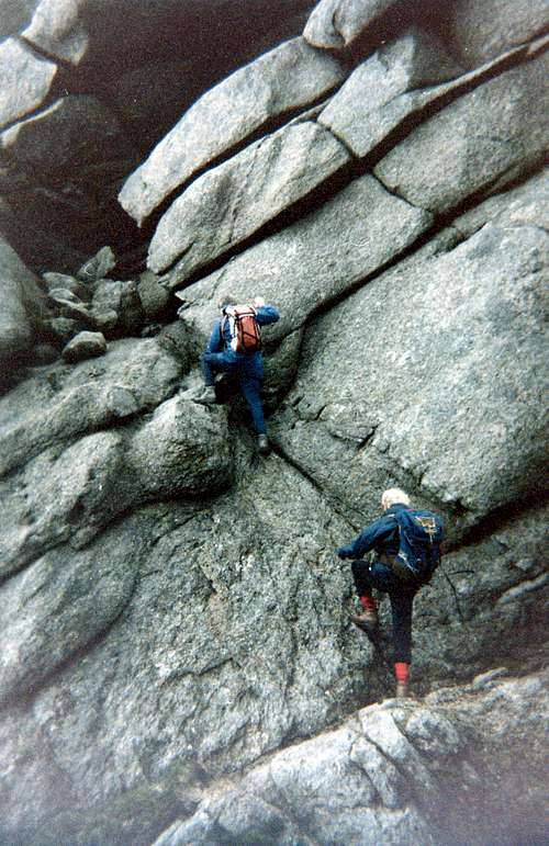
Scrambling over granite.
One area where a rope is advisable is when you follow the ridge over the summit of Bheinn Tarsuinn towards Cir Mhor as downclimbing can be a bit hairy in places.
In other areas the scrambling is great fun over great boiler plates of cracked ledges and walls.
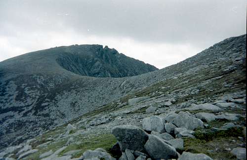
Once on the top of either west or east ridge, the eye is spectacularly lead in the direction of the summit of Cir Mhor by the curious and sometimes wierd shapes of the rocks.
Old granite bedding makes the Arran ridges a great place for scrambling along on the tops.
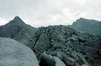
Shattered bedding planes.
Navigation is reasonably straightforward even in cloudy conditions due to the regular topography of these beautiful ridges.
Well defined trails also mark the safe routes on the ridge lines where they do not cross areas requiring scrambling.
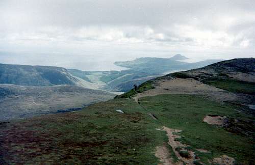
View to the coast and Holy Island
Up on the ridge, the views are uninterrupted, right down to the coast.
The picture alongside is taken looking down over Glen Rosa, across Brodick bay and out to sea and as far as the conical spire of Mullach Mor (314 metres) on Holy Island.

The ridge to Goat Fell
If the eastern trail is taken from Glen Rosa, you will arrive on the saddle shown on the left and see the lower slopes of the ridge before you that lead up over the top of North Goatfell (810 metres) and from there onwards to the island’s highpoint of Goatfell.
Scrambling over these granite pinnacles is great fun and gives fine views of Glen Rosa to the southwest and Glen Sannox to the northwest.
The ridge between the two summits soon follows and is a steady scramble up the 60 odd metres of height gain needed to arrive on Goat Fell
A Trig station on the summit marks the highest point of Arran and is situated in a field of granite boulders.
With the benefit of clear weather, a clear 360 degree view of the whole island is seen and also views back east to the mainland and out towards the Mull of Kintyre in the west.

Summit of Goat Fell
Once the visitor has bagged the highest point they are free to visualise wandering around the rest of the peaks and their connecting ridges.
From the Goat Fell summit it is possible to follow an alternative route back to the campsite by taking the south ridge down to Coire nam Meann and then follow the trail through a pine plantation on to Brodick Castle close to the coast. From the castle follow the A841 road southwest to the river bridge and then take the trail up Glen Rosa back to the campsite.

Descending from Goat Fell
Glen Sannox
Glen Sannox is a near perfect example of a glaciated U shaped valley and leads down to the coast on the Firth of Clyde.
At the end of the glen can be found prehistoric sites with standing stones, chambered cairns and a fort, marking the arrival and residence of visitors to the island before the dawn of recorded history.
Ridges in every direction, extending as far as the eyes can see, sheer heaven for mountain people. Nowhere is anything really serious encountered but the excitement of wandering freely enjoying the walking and scrambling make this part of Arran a paradise.....

Ridges of Arran
Ridges of Arran
You would probably need more than a week’s stay on the island to do all these ridges and tops justice.
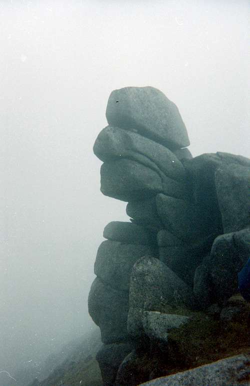
The Grey Man
Some strange sights may greet you as you travel along the high ground but be not afraid, Arran is a friendly place, you’re not likely to hear the footsteps of the “Great Grey Man” following you as has sometimes been reported in other parts of the Scottish hills.

Way of Escape
If you do get frightened by your fertile imagination whilst walking through the eerie mists, make a swift retreat down a handy coire and get back to Brodick to select a few stiffeners off the excellent whiskey menu in the Ormidale Hotel.
Fear not the old grey man!
But the bones of the earth are very near the surface here!

The bones of the Earth
The Peaks on Arran
 Arran Hills from Brodick. Extract from SMC Journal Volume.3 No.4
The Island of Arran is generally described as ‘Scotland in Miniature’. The main peaks of the island are found to the north, with some less frequented peaks found to the west and south. Below are the main peaks of the island;
Goatfell
Standing at a height of 874m, Goat fell is a Corbett and the highest peak on the Island of Arran. There are two possible translations for Goatfell. The first is from the Norse Geita-Fjall, meaning Goat Hill. The second is from the Gaelic Gaoithe Bheinn, meaning Windy Hill. If you are fortunate enough to get a clear day on Goatfell, then the view you will have is amongst the finest in all of Scotland. The surrounding peaks, sunlit seas and the nearby isles make a fantastic combination. A Bristol Beaufort Mk1 crashed here in 1942 while on night navigation killing all 4 crew members.
Mullach Buidhe
Situated east-north-east of Goatfell, Mullach Buidhe (Translation: Yellow Hill) stands at 819m. Before reaching the summit, take time to examine the famous Cyclopean buttress to the west, which is undoubtedly the finest on Arran. This was also the site of an aircraft crash in 1941, where an LB-30A Liberator RAF plane crashed into the mountain ridge in poor visibility killing 17 passengers and 5 crew.
Cioch na h‘Oighe
Situated to the north of Mullach Buidhe, Cioch na h’Oighe (Translated: The Virgin’s Breast) is a grand mountain rising to 663m that is rocky on all sides, with a long cliff over 200m high. The cliffs to the east drop sharply into the Punch Bowl 300 metres below. These cliffs provide some of the finest rock climbing to be had on the island. The connecting ridge between the two peaks is narrow and exposed, providing an excellent scramble that would be ill advised in winter conditions to the average walker.
Caisteal Abhail
The second highest of the four Corbett peaks on Arran, Caisteal Abhail (Translation: Forked Castle) is located to the northwest of the main range and rises to 859m. Also known as The Sleeping Warrior due to its distinctive profile seen from the mainland, Caisteal Abhail’s most famous feature is the Ceum na Caillich (The Witch’s Step). This is a deep gash in the ridge that drops 150 feet to the saddle and is very difficult to negotiate. It can be avoided by traversing northwest round ledges before the gash that lead to the saddle.
Beinn Tarsuinn
Beinn Tarsuinn (Translation: Transverse Hill) is the third Corbett peak on the island and is 826m high. Lying between Glen Rosa to the east and Glen Iorsa to the west, Beinn Tarsuinn is usually climbed in conjunction with Cir Mhor. The two peaks are linked by the subsidiary top of A’Chir (745m), which the crossing of, involves an entertaining scramble that is often compared with the Cuillin ridge of Skye.
Cir Mhor
Cir Mhor (Translation: Big Comb) is the last of the Corbett peaks of Arran and sits at 798m high. The name comes from the peaks resemblance to a cockscomb. Although not the highest peak in the range, Cir Mhor is justly described as the finest peak in the range. It forms, roughly, a triangular pyramid shape that faces one side towards Glen Iorsa, another to Glen Rosa and the third to Glen Sannox. Cir Mhor provides some of the best rock climbing on the Island (See diagram below).
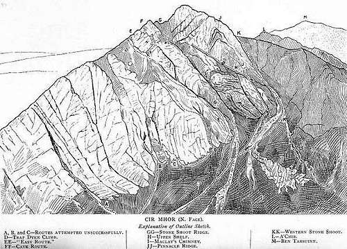 Cir Mhor North Face. Extract from SMC Journal Volume.3 No.4
Beinn Nuis
Standing at a height of 792m, Beinn Nuis is located to the south of Beinn Tarsuinn and is unfortunately the site of three aircraft crashes. The first 2 crashes occurred in 1943 with the third in 1944. The first was a B-24D Liberator which flew into the western side of the mountain while being flown from Gander to Prestwick. All 10 crew members died on impact. The second, crashing in almost the exact spot, was a Lockheed C-60A Lodestar USAAF plane which crashed while flying from Keflavik to Prestwick. The third crash was on the eastern face of Beinn Nuis and involved a B-17G of the 560th Bombardment squadron with all 10 crew members killed.
Beinn a‘Chliabhain
At a height of 676m, this peak is located to the east of Beinn Tarsuinn and to the west of Goatfell. Most notable for the huge slab like stones on its narrow crest that are flanked by granite pinnacles.
Suidhe Fhearghas
Rising to 634m and located to the north of the main Arran range, this peak is a prominent landmark when seen from Sannox Bay. The peak is flanked by crags, but presents no great difficulties in attaining its summit.
Beinn Bharrain
The highest of the peaks on the western side of the island, Beinn Bharrain (Translation: Barren Hill) is the name given to the twin topped hill, with the highest of the two also being known as Mullach Buidhe. Both tops have well defined parallel ridges that enclose Coire Roinn. Not as popular as the eastern hills of Arran, Beinn Bharrain is well worth visiting as it is secluded and gives fine views over Kilbrannan Sound towards Kintyre, Islay and Jura.
Tighvein
Tighvein is a Marilyn and the highest point in the south-east of Arran at 458m. Located two miles from the nearest road, the summit is heathery and boggy and almost entirely ringed by thick forestry plantations. Due to these facts the peak is understandably not as popular as others on the island.
Rock Climbing
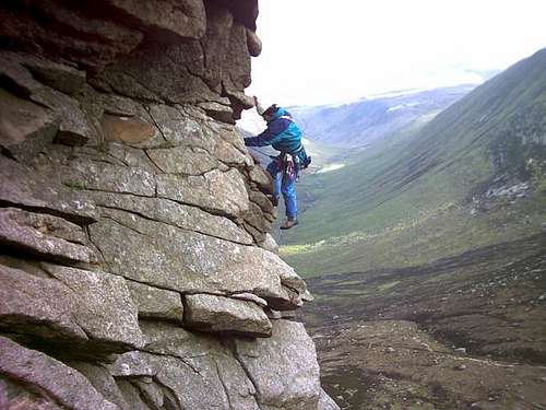
Neil on Caliban's Creep (photo by Russell)
The rough granite and the rounded forms of the Arran rocks make for some interesting challenges for the rock climber, see:
Arran, Arrochar and the Southern Highlands 1997 Scottish Mountaineering Club. Summer and winter climbing on the granite of Arran, the schist of Arrochar, and the frozen turf and ice of the Southern Highlands. Includes The Cobbler, The Bridge of Orchy Hills and Beinn Udlaidh. Colour illustrations, route diagrams and maps. 385 pages.
The following brief report from MYLES gives us a flavour of the possiblities.
You'd asked about some notes for climbing on Arran, I've been there
several times including twice for climbing trips. The only climbing I've
done there has been on Cir Mhor (South Ridge, Sou'wester Slabs, and
Caliban's Creep) and a v. diff, Aquila (I think it's called) on the crag
above Lochranza (my local friends called it "the Tor," but it has a longer
Gaelic name, I believe Torr Nead an Eoin.
I guess the thing that stood our most for me was the incredible
friction on Arran granite that made anything less than vertical a lot of
fun, what with the sticky rubber on modern rock boots.
There's also some interesting looking climbing on the West coast of the
island on basaltic columns near the golf course at Drumadoon.
Another note on Glen Rosa--there are some good places to doss beneath Cir
Mhor, even without a tent. Just leave no trace.
A couple of rest day or poor-weather activities: Brodick Castle and
gardens were fun (my climbing partner in Scotland used to be a gardener
there before moving to House of Dun in Montrose). The distillery at
Lochranza is Scotland's newest, and Lochranza Castle has been opened after
some structural renovation. I also very much enjoyed the Arran museum near
Arran Aromatics.
Thanks for setting up a page dedicated to a truly beautiful island.
Best,
Myles
Maps and Guides
Navigation around Aran is pretty straight forward and the topology is simple but it's handy to plan your trip with a map and a guidebook so I've listed the main ones below.
Of course, in these days of portable GPS satellite navigation systems many think that the paper map is redundant but my feelings are still stirred by successful navigation around the hills in mist or whiteout conditions using my faithful Silva compass and my ordnance survey map.
Maps:
Harvey Superwalker Map - Isle of Arran
Ordnance Survey Landranger 69 - Isle of Arran - 1:50,000
Ordnance Survey Explorer 361- Isle of Arran - 1:25,000
Guides:
The Scottish Peaks by W. A. Poucher
The Corbetts and Other Scottish Hills by Rob Milne & Hamish Brown
Islands of Scotland by Derek Fabian, Graham Little & Noel Williams
Arran, Arrochar and the Southern Highlands by Graham Little, Tom Prentice, Ken Crocket
Red Tape
There is no Red Tape, In fact due to legislation in the Scottish Parliament, freedom to roam the hills is enshrined legally. Although England has a Scottish PM we are still way behind Scotland in giving folks free ranging access to beautiful mountain areas like those on Arran.
The Land Reform (Scotland) Act 2003
Scottish Outdoor Access Code
The following aspects should be taken into consideration when you are in the Scottish countryside;
- Seek local advice in regard to deer stalking or grouse shooting activities (see previous section)
- Ensure that all gates are closed behind you
- During the lambing season (March to May) ensure that all dogs are kept on a lead
- Please refrain from feeding or annoying any animals
- Limited parking space is available at the start of many routes, please ensure that you are not blocking a road and/or entrance
- Parking is provided at the start of some routes by the local farmers, it is polite to ask if you can use this facility
- Try to refrain from crossing fields with animals and/or crops if an alternative route is available
- Ensure that you treat the local environment with care by leaving it as you found it and by taking any litter home with you
- Any camp fires should be carefully watched and only used away from dense forest areas
- Natural waste should be done in a hole and then buried when wild camping
Weather/Mountain Forecast
The following links provide info on the weather/mountain conditions for the Island.
Mountain forecast
West Highlands forecast
Useful Links
Transportation to the Island from the mainland is via the two ports mentioned above using the: Caledonian MacBrayne ferries
General Tourist information about Arran is available from: Visit Arran
The Ormidale Hotel website has a lot of information about services available.
Visit Scotland
Discover Scotland
Undiscovered Scotland
The Scottish Mountaineering Club
Hill Phones
Deer Stalking Scotland
Isle of Arran