
|
|
Area/Range |
|---|---|
|
|
55.42626°N / 3.32091°W |
|
|
Hiking, Mountaineering, Trad Climbing, Ice Climbing, Mixed, Scrambling |
|
|
Spring, Summer, Fall, Winter |
|
|
2694 ft / 821 m |
|
|
Overview
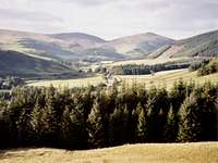
The Moffat Hills is part of the Southern Uplands, an extensive area of outstanding natural beauty in the south of Scotland that crosses through the two counties of Dumfries and Galloway and the Scottish Borders. The Lat/Long I have given in the page is that of the areas highest summit called White Coomb.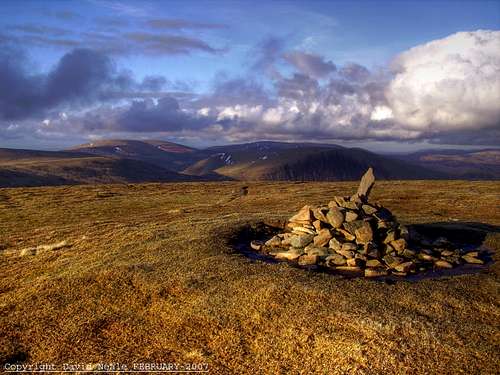 The small and lonely cairn on the vast summit of White Coomb
The area consists of large open summits in excess of 800 metres, which all have very impressive glaciated valleys with many corries, crags, gullies and waterfalls. The area also features large natural lakes, man made reservoirs and various rivers of great fame such as the great River Tweed.
Most people when heading north into Scotland are off to the wilds and mountains of the Highlands north of Glasgow and Edinburgh, or those of the Lake District just before Scotland in Cumbria. The Moffat Hills region is rarely touched even though it is within such easy reach off the A74(M) motorway from Carlisle to Glasgow. It is only 35 miles into Scotland from the English border and not even a 100 miles south from the cities of Edinburgh and Glasgow.
The area that the Moffat Hills covers is so complex and diverse featuring interests to suit everybody. I hope the following will cover as much as I can from my many visits to this magical and wonderful area of Scotland.
The features within this lovely area will be described in sections and we start off with of course... The Mountains and Summits
The Mountains and Summits:-
The region of the Moffat Hills has really exciting areas to explore with vast open and round summits interconnected with snaking ridges along with deep glacially cut gullies presenting meandering waters and impressive waterfalls.They can be done in all weathers but the area can be highly dangerous in the worse winter conditions as most of the highest points can not be seen easily from the roads. This is due to the glacially cut valleys being so deep and having such steep sides. Mobile phone service is also very patchy up here. Still take one with you but don’t think that a mobile will always work.
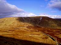
 The large Corbett summit of White Coomb seen from the upper reaches of Tail Burn
The meaning of White Coomb is hill carved out on one side and this is definitely true as on its south-eastern side there are some impressive cliffs and corries cut out by extreme glacial action. The summit is marked by a very small lonely cairn.
White Coomb is also a Scottish Corbett as in a summit over 2500 feet but below 3000 feet. 3000 feet or higher in the Scottish summits then becomes a Munro.
The views from this summit are impressive in that summits as far as the Highlands are visible on the clearest of days. I climbed White Coomb on a clear but cold day in February 2007 with the odd patch of snow here and there. I could see as far north as the summits of Ben Ime in the Arrochars, Ben Lomond near Loch Lomond and Ben Vorlich near Lochearnhead.
The view south was the complete Ettrick Hills as they are only the other side of the Moffat Dale valley. The Pennines with the most northern summit of Cross Fell at 893 metres are in full view when you look south into England.
These are visible near the Cumbria towns of Penrith and Carlisle along with many of the Lake District Mountains. Views cover summits over 100 miles away. Now that is a great distance to be able to view from a summit below 3000 feet.
  |
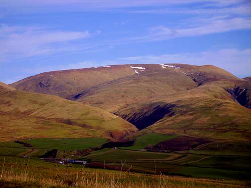 The large Corbett summit of Hart Fell seen from Annandale
At 808 metres Hart Fell is at the far north-western end of the hills overlooking the glacially cut valley of Annandale and has some fantastic ridges and routes to access it. The summit has an OS trig point along with a wind shelter and commands fine views north and south as with White Coomb.
Where Hart Fell does better in the views is when you look west from the summit the complete Galloway Forest summits are visible as far as Merrick.
One of Hart Fells western ridges has a famous gully with waterfalls called Hartfell Spa which has a chalybeate spring contained within a small stone structure. Legend has it that Merlin the Magician spent his final years living here before the locals killed him at Drummelzier a few miles north on the Tweed. Most enigmatic is that of King Arthur's Merlin who is rumoured to have retreated to Hart Fell following defeat whilst at battle in 573. Signs of his presence can be found in names of the surrounding land features, Arthur's Seat being a satellite top of Hart Fell is the most obvious, though less well known than its Edinburgh counterpart, while Merlin's Cave can be found just below the ridge.
These two summits also fall into the category of Marylins. These being a mountain or hill in the British Isles (including Ireland) with a relative height of at least 150 metres (492 ft), regardless of its absolute height or other merit.
Within the Moffat Hills there are no other summits that register as a Corbett or Marylin, but the rest of the summits and tops are mainly registered as Donalds. Donalds are summits and tops over 2000 feet that have a fall of 30 metres or more in all directions. What gets confusing is summits in the end have way too many categories so I will leave it at Corbett’s, Marylins and Donald’s for now.
One web site I know covers the summit of Broad Law as a Moffat Hills summit…? This to me though is in the neighbouring area called the Manor Hills. I have to say if you are in the area Broad Law is worth a go as it is another Corbett and Marilyn at 840 metres. It is the second highest summit in Scotland on main land south of Ben Lomond. The highest is that of Merrick only 3 metres higher at 843 metres.
 The crags of Lochcraig Head seen from the ridge of Mid Craig
The first one I will start with is that of Lochcraig Head at 801 metres meaning Crags over the Lake.
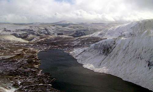
The south facing glacially cut crags of this summit are an amazing feature when seen across the waters of the high natural lake of Loch Skeen / Skene. Lochcraig Head looms over these waters like a dome sliced out on one side and when on Lochcraig Heads summit the views down onto the waters of Loch Skeen / Skene are also very impressive.
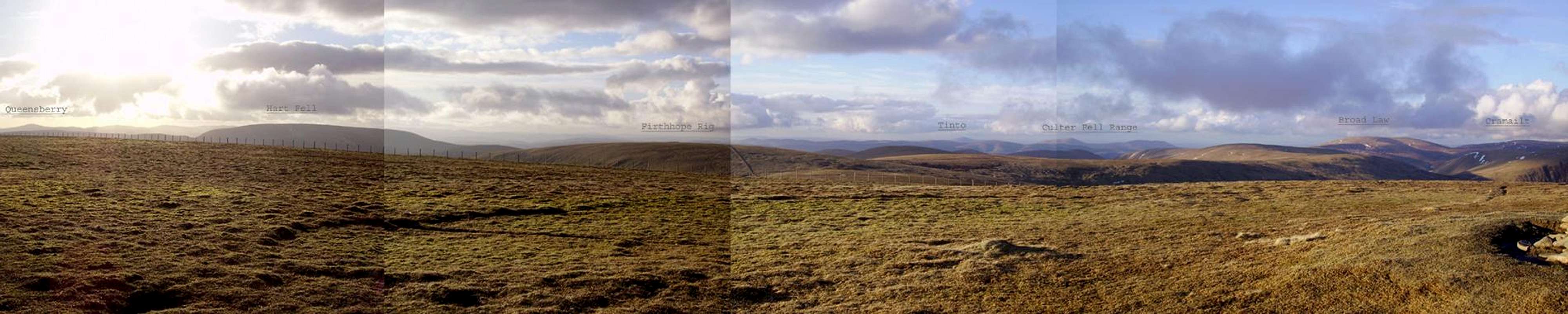
 Firthhope Rig across Rotten Bottom
 Saddle Yoke from Moffat Dale
 Carrifran Gans from Moffat Dale
Like White Coomb, Lochcraig Head presents fine views both north and south. Lochcraigs crags along with White Coomb and an intermediate ridge called Mid Craig are all the results of glacial action that carved out these upper levels on the summits and also created the beautiful hanging valley of Tail Burn along with the famous Grey Mares Tail waterfall.
After Lochcraig Head the next one is that of Firthhope Rig at 800 metres. This is a rather bland top but is still registered as a Donald so has to be added if you are covering all the summits and tops in the area. Firthhope Rig is just to the west of White Coomb and has a very small stone cairn. There is no real excitement on this top and as White Coomb is visible in such a short distance it is kind of like done Firthhope Rig lets get and move on. The views though as Firthhope Rig is at 800 metres are again very good when looking north but south is a different matter as the ridges of Carrifran and Saddle Yoke along with the mass of White Coomb in the east block the views.
There are no other summits / tops over 800 metres but the rest of the major tops within the Moffat Hills are still very impressive.
Most of these are combined within great ridge walks as most ridges that lead onto the Moffat Hills have distinct tops of there own registered as Donald’s before dropping off onto the flat peat bogs that lay between them all.
The best ridges with serious crags and valleys are all on the very southern side of the hills. These crags and valleys all join with the valley of Moffat Dale and were again all created by the glacial action.
The two main ridges with attitude are those of Saddle Yoke and the Carrifran.
Saddle Yoke is a long shapely ridge with two tops called Saddle Yoke and Under Saddle Yoke. The highest point along the ridge is that of Under Saddle Yoke at 745 metres and to get there is a steep climb up from the valley of Moffat Dale. It is also dominated on both of its sides by deep glacially cut valleys.
To its west side is the valley of Black Hope and to its east side is the valley of Carrifran Glen. The crags or known here locally as Craig's in these two valleys are amazing and when ascending Saddle Yoke the views just get better and better the higher you get. Saddle Yoke can be used within circular routes to access both the summits of Hart Fell and White Coomb. If you access Hart Fell the best return route down is along the other side of Black Hope via Swatte Fell so you get a complete picture of the valley and its vast scale. If you are accessing White Coomb from Saddle Yoke then the best return is down via The Carrifran.
The Carrifran is an impressive ridge walk either way and is 757 metres at its highest point called the Carrifran Gans. Returning via Carrifran presents great views across the Carrifran Glen to the ridge of Saddle Yoke. The Carrifran is also very steep when descending back down into the valley of Moffat Dale but there is always the fence line you can follow to keep yourself stable.
 Saddle Yoke
 Carrifran Gans
 White Coomb
On the high and rather flat barren landscape between the upper summits lies an area with the aptly named Rotten Bottom. Be aware when out on this area. The name suits the area well as this is a serious peat bog and can be dangerous to cross in certain weather conditions. The water that lies in the area can be very deep and you must choose your route across here carefully. This area mainly affects routes between the ridges of Saddle Yoke and the summits of White Coomb and Firthhope Rig. If you take this route and go the wrong way through it you may end up with very wet feet or in the worst case getting yourself stuck in the dark rotting peat...! There are other areas wet and boggy in the hills but the Rotten Bottom is definitely the worse.
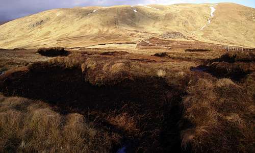 The Rotten Bottom peat bogs with Firthhope Rig in the background
 Garelet Hills Trig
For such a large area of hills there are only four trig points to bag if you also include these in your hill walking.
The highest of these is that of the summit Hart Fell OS-Trig # S1556 at 808 metres as mentioned previously.
Also the area has Garelet Hill OS-Trig # S5045. Although the trig point is only 680 metres the hill is very impressive. It overlooks the waters of the Talla Reservoir and commands great views across to the Manor Hills with Broad Law and its steep ridges that rise out of the Talla area clearly visible and giving great scale of Broad Laws magnificence. Broad Law is the second highest Scottish summit on main land south of Ben Lomond. The highest is that of Merrick. Garelet Hill when seen from the road driving along side Talla Reservoir has a massive scar of crags and rocks that which really set this hill off.
There are two other trig points within the Moffat Hills.
Craigmaid OS-Trig # S6123 at 553 metres is a small isolated hill to the north of Tweeds Well and between the valley of the River Tweed and the Fruid Reservoir.
The last of the trig points is Annanhead Hill OS-Trig # S5678. This is only 478 metres but being at the head of Annandale and above the large glacial torn corrie of the Devils Beef Tub the views are great. Looking north gives views towards the Culter Fell ranges and the Gathersnow Hills. East looks across deep into the wilds of the Moffat Hills with Hart Fell dominating. South looks directly down the valley of Annan Dale towards the town of Moffat. West gives views of Queensbury and the Lowther Hills.
Annanhead Hill is the easiest trig point to access in the complete area. Just park up at the top of The Devils Beef Tub where there is a forest track. Follow the fence line from here all the way and your there. It is only a 15-20 minute walk with rewarding views.
Table of Summits and OS-Trig Points:-
| Summit Top - Name | Height m | Height ft | OS-Map | Grid Ref and Streetmap Links | Marilyn | Corbett | Donald |
| White Coomb | 821 | 2694 | 79 | NT163150 (Streetmap Link) | TRUE | TRUE | TRUE |
| Hart Fell | 808 | 2651 | 78 | NT113135 (Streetmap Link) | TRUE | TRUE | TRUE |
| Lochcraig Head | 801 | 2628 | 79 | NT166176 (Streetmap Link) | FALSE | FALSE | TRUE |
| Firthhope Rig | 800 | 2625 | 79 | NT153153 (Streetmap Link) | FALSE | FALSE | FALSE |
| Molls Cleuch Dod | 785 | 2575 | 79 | NT151179 (Streetmap Link) | FALSE | FALSE | TRUE |
| Great Hill | 774 | 2539 | 78 | NT145163 (Streetmap Link) | FALSE | FALSE | FALSE |
| Firthybrig Head | 764 | 2507 | 79 | NT158172 (Streetmap Link) | FALSE | FALSE | FALSE |
| Nickies Knowe | 761 | 2497 | 79 | NT164191 (Streetmap Link) | FALSE | FALSE | FALSE |
| Carrifran Gans | 757 | 2484 | 79 | NT159138 (Streetmap Link) | FALSE | FALSE | FALSE |
| Under Saddle Yoke | 745 | 2444 | 78 | NT142126 (Streetmap Link) | FALSE | FALSE | TRUE |
| Carlavin Hill | 736 | 2415 | 78 | NT142188 (Streetmap Link) | FALSE | FALSE | FALSE |
| Saddle Yoke | 735 | 2411 | 78 | NT144123 (Streetmap Link) | FALSE | FALSE | FALSE |
| Swatte Fell | 729 | 2392 | 78 | NT120115 (Streetmap Link) | FALSE | FALSE | TRUE |
| Falcon Craig | 724 | 2375 | 78 | NT122127 (Streetmap Link) | FALSE | FALSE | FALSE |
| Nether Coomb Craig | 724 | 2375 | 78 | NT129109 (Streetmap Link) | FALSE | FALSE | FALSE |
| Cape Law | 722 | 2369 | 78 | NT131150 (Streetmap Link) | FALSE | FALSE | TRUE |
| Garelet Dod | 698 | 2290 | 78 | NT126172 (Streetmap Link) | FALSE | FALSE | TRUE |
| Erie Hill | 690 | 2264 | 78 | NT124187 (Streetmap Link) | FALSE | FALSE | TRUE |
| Laird's Cleuch Rig | 684 | 2244 | 78 | NT125196 (Streetmap Link) | FALSE | FALSE | FALSE |
| Din Law | 667 | 2188 | 78 | NT124156 (Streetmap Link) | FALSE | FALSE | FALSE |
| Whitehope Heights | 637 | 2090 | 78 | NT095139 (Streetmap Link) | FALSE | FALSE | TRUE |
| WhItehope Knowe | 611 | 2005 | 78 | NT098144 (Streetmap Link) | FALSE | FALSE | FALSE |
| Ellers Cleuch Rig | 610 | 2001 | 78 | NT127167 (Streetmap Link) | FALSE | FALSE | FALSE |
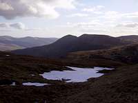
 View across Loch Skeen / Skene from Lochcraig Head with Ettrick Pen in the distance
| Trig Points | Height m | Number | OS-Map | Grid Ref and Streetmap Links |
| Hart Fell | 808 | S1556 | 78 | NT113135 (Streetmap Link) |
| Garelet Hill | 680 | S5045 | 72 | NT124201 (Streetmap Link) |
| Craigmaid | 553 | S6123 | 78 | NT074177 (Streetmap Link) |
| Annanhead Hill | 478 | S5678 | 78 | NT058132 (Streetmap Link) |
Getting There:-
A section of map covering Moffat and the Moffat Hills from streetmap Moffat Hills area map
Accessing Moffat via motorway:-
Situated just off Junction-15 of the A74(M) motorway that links Carlisle and the M6 motorway in England through to Glasgow makes Moffat such an easy town to get to. The M6 motorway links with the main cities in England such as Birmingham and Manchester and is also the longest stretch of motorway in the UK.
Junction-15 of the A74(M) is with the A701 Dumfries to Edinburgh road and Moffat is clearly signposted from this junction on the motorway. It is also clearly signposted from Dumfries town centre.
From Edinburgh the A701 is the main link road from the A702 Edinburgh bypass head south via Penicuik and Peebles then head all the way up the Tweed Valley through to Moffat.
From the eastern area head for the town of Selkirk and then take the A708 road signposted for St Mary’s Loch and Moffat. This road when travelled along for the first time can seem a long tedious drive because it is narrow in places and winds round for about 30 miles before you reach Moffat. The one thing is the scenery on this road makes it worth it.
Bus services available to Moffat are from:- Dumfries, Carlisle, Selkirk, Glasgow and Edinburgh. The Edinburgh service runs via the towns of Penicuik and Peebles.
The nearest main railway station is that of Lockerbie a town just to the south of Moffat which also has bus services to Moffat. So a journey part by train and part by bus is available. The station of Lockerbie is situated on the high speed line from London Euston to Glasgow. This line also has connections with Birmingham New Street and Manchester Piccadilly.
Major airports with international connections and car hire companies are plenty:- Newcastle International airport just on the east side of England is about a 100 mile drive away from Moffat. The Scottish airports with international connections are them of Edinburgh, Glasgow and Prestwick. Moffat is within an easy drive, train or bus journey from all these airports.
View Larger Map
Navigation with Ordnance Survey Maps:-
The Moffat Hills area strangely falls across more than one Landranger 1:50 000 Ordnance Survey map but is covered across the area of four different sheets. This can make things difficult carrying loads of maps but Ordnance Survey have a 1:25 000 map that covers the complete area available in both paper sheet and laminated waterproof plastic. Maps for the area are listed below with details of areas they cover.
Ordnance Survey 1:50 000 Landranger series:-
Landranger 72 Upper Clyde Valley – Biggar and Lanark
Covers Tweedsmuir and Talla Reservoir
Landranger 73 Peebles, Galashiels & Selkirk – Tweed Valley
Covers Cappercleuch and St Mary’s Loch
Landranger 78 Nithsdale & Annandale – Sanquhar & Moffat
Covers Moffat town Moffat Dale, Annan Dale and the summit of Hart Fell
Landranger 79 Hawick & Eskdale – Langholm
Covers Loch of the Lowes, Moffat Dale, Loch Skeen / Skene and the summits of Lochcraig Head and White Coomb.
Ordnance Survey 1:25 000 Explorer series:-
Explorer 330 Moffat & St Mary’s Loch – Megget Reservoir
Covers the complete area of the Moffat Hills along with the Ettrick Hills in the south region and part of the Manor Hills with Broad Law in the north region.
Ordnance Survey 1:250 000 Road series:-
Road map 3 Southern Scotland and Northumberland
Covers the roads from the northern reaches of England around Carlisle across to Newcastle. The map also covers the southern area of Scotland down from Oban and Dundee.
Ordnance Survey Website Link:-
Ordnance Survey
The town of Moffat, local villages and the area that makes the Moffat Hills:-
MOFFAT AS A TOWN:-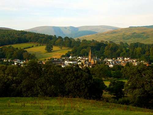 Moffat town with the Moffat Hills behind seen from the golf course
Moffat is a relatively small but busy Scottish market town with more of the local population in the shops than tourists and visitors. Coaches do there quick stops here from there long motorway journeys when heading for the Highlands but these stops are normally a one hour lunch or meal break.
Of course within an hour you cannot get to find much out about the hills as they are over to the east of town and only a few of them are visible from the town of Moffat itself. Moffat has plenty of shops for a small town along with cafes, restaurants, tea shops and take aways. If you have never tried it before ask a fish and chip shop to do you a deep fried Mars Bar. I tried one for my first time in August 2008 and it was very nice.
There are tourist shops for those who like browsing about for gifts etc, a co-op mini market for your sandwiches and food when out on the hills. Moffat also has many hotels in the town centre and a lot of bed and breakfasts on its outer streets. A little rhyme I thought of was:-
Moffat is small but does have it all...!
There are some interesting features in Moffats pretty town centre. The road system is rectangular in plan with car parking in the centre of the two roads that run parallel to each other. The reason for this road layout is many years ago before cars which of course can just reverse out of there parking places which is a feature that horse and carts in the old days could not do. Therefore the horse and carts could do a complete turn around by going round the block.
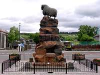 Moffat town with the Moffat Ram
Also in the town centre is a sculpture of a ram known as the Moffat Ram. This is a more-recent memorial to that time, its fountain designed to provide water to dogs, horses and men. Until they were removed, iron cups chained to the fountain allowed men to drink from the water-spouts. The granite basins for dogs are at the base of the fountain, whilst those for horses are at a convenient level. For all its hoary appearance, the Moffat Ram was only set up in 1875, a gift to the town by William Colvin of Craigielands, Beattock. The architect was Mr. Brodie, RSA of Edinburgh; it is said that the poor man took his own life after the Ram was cast with its horns but without its ears. The writer has still to verify the truth of this tale.
Second we have the sections that divide the Moffat Hills into there designated area:-
The Moffat Hills area is enclosed in a triangle divided by three main roads and three towns / villages.
These consist of the A701 main road from Moffat through to Tweedsmuir. The A701 is the main road to Edinburgh that climbs up from Moffat along the west side of Annandale valley and then heads down to the small village of Tweedsmuir through the valley of Tweedsdale.
When at Tweedsmuir there is a small road signposted Talla and Megget. This is an unclassified road that winds for 11 miles through some serious and wild countryside in the mountains, large man made reservoirs, rapids and waterfalls along with steep roads and in the end this small road meets up with the A708 Selkirk and Moffat road at the very small village of Cappercleuch marked with an old AA phone box.
When at Cappercleuch the A708 heading towards Moffat takes you along side the vast waters of St Mary's Loch and the Loch Of The Lowe’s ( These are both natural lakes ) then on up to the water table at a place called Birkhill. Birkhill is the point at the source of Moffat Water a river that heads down through the deep glacially cut valley of Moffat Dale and then on into Moffat town again.
Tweedsmuir is a picturesque little village situated along the banks of the great River Tweed. Where the River Tweed passes through this village there is a very impressive set of rapids that run through rocks and boulders and pass under the village’s medieval road bridge. These are the first true rapids to be seen on the River Tweed from its source at Tweeds Well about 7 miles up stream. The rapids are seen at there best after a very heavy rain fall as the river narrows considerably at this point the swell of water created here in these conditions is impressive. There is a lovely Victorian church down the side road in the village built with red sandstone and the church has a small but very nice spire that looks over the village. This church is known as the Tweedsmuir Kirk more information on the church via this link Also from Tweedsmuir is a dead-end road through to the gigantic man made reservoir of Fruid which will be mentioned later.
Cappercleuch is a small settlement in the Ettrick Forest district of the county called Scottish Border. The village lies at the junction of the Meggat and Yarrow valleys, to the west of St. Mary's Loch and is about 16 miles north-east of Moffat. In 1978 the Megget Dam was built 2 miles (3 km) to the west, impounding the Megget Reservoir, the longest reservoir in SW Scotland which will be mentioned later. Also in the village of Cappercleuch is a very interesting phone box at the junction of the Tweedsmuir road and the A708 Selkirk road. This is an old AA roadside assistance call box and is now a listed building as there are not many left in the country.
The two small villages of Tweedsmuir and Cappercleuch do not have any shops. The good news is that If you drive round these areas in the day there is always the Glen Cafe on the A708 Selkirk road and along side Loch Of The Lowe’s which does food, snacks and drinks. The service here is always good especially there panini's and cakes.
 Tweedsmuir Rapids
 Tweedsmuir Kirk
 Cappercleuch AA-Box
The Geology and landscape of the area:-
 A geological map representing the South Scotland area of Dumfries and Galloway and the Scottish Border
The Moffat Hills have a rich and varied landscape which is the result of aeons of geological activity combined with the relatively recent impact of man. Continents have collided, volcanoes have erupted, ice ages have come and gone and mighty rivers have eroded the landscape. On a miniature scale, and in the last few moments of this story, farmers and
forester’s have begun to scratch away at the surface of the land.
In Southern Scotland, Devonian and Carboniferous rocks are found mostly in the south and east. A typical scene in Devonian times is thought to be that of powerful, fast flowing rivers bringing sediment into lakes. By Carboniferous times Scotland was near the equator and our landscape was one of rainforest and tropical seas. Thick red sandstones show that by Permian times the area had become a desert.
The last part of the ice age was relatively recent, lasting from about 70,000 to 12,000 years ago. At one stage the whole of Scotland was under a great sheet of ice. Latterly the main ice accumulations in south Scotland were north of Glentrool, and in the Moffat Hills and Tweedsmuir. Examples of glacially eroded valleys can be seen at Annan Dale, Black Hope, Carrifran Glen and the Valley of Moffat Dale, especially at The Grey Mare’s Tail and Tail Burn.
Just a few interesting Geological places in the area:-
Moffat Water Valley
This is a classic glaciated valley with a wide valley bottom and steep sides. From the Way, it is best seen at the start of the long climb to Ettrick Head, east of Moffat. Here and there among the gently rounded hills the underlying rocks are exposed, particularly at Craigmichan Scar, beside the Way.
Dobb’s Lin
This is a world famous geological site where Charles Lapworth, a Galashiels schoolteacher, provided geologists with the key to unlocking the mysteries of the Southern Uplands. He studied the fossil remains of tiny sea creatures called graptolites found in black shales and
published his findings in The Moffat Series (1878).
St Mary’s Loch and Loch of the Lowes
Glaciers spilling over from the Moffat and Megget hills carved out the basin for these lochs before travelling on to Yarrow. Once a single loch, it has since been divided by the alluvial deposits brought in by the Crosscleuch and Ox Cleuch Burns. Alluvial gold has been extracted from Glengaber Burn, near Megget Reservoir.
 The famous corrie of the Devils Beef Tub, source of the River Annan
 The corrie of Dobb's Lin, source of Moffat Water
This area has valleys, vales, dales and corries of all shapes and sizes which are primarily on the south side of the hills. Many of these are the result of glacial action which the most impressive has to be that of Moffat Dale. Starting in an impressive corrie called Dob's Lin the glacier cut through the south of the Moffat Hills in a west direction and also divides the Ettrick Hills to the south from the Moffat Hills. The cliffs and steep banks when looking down Moffat Dale are impressive in that a photograph cannot show or compare the scale of it. You have to be there and see it to know what I mean. The best view for this is near the water table at Birkhill from the small ridge of Path Knowe above the corrie of Dob's Lin. Moffat Dale is joined by three other amazing valleys. These are the valleys of Black Hope, Carrifran Glen and Tail Burn. All three of these are glacially cut valleys deep into the hills. The one that gets the most attention is always Tail Burn as it has one of Scotland’s most famous waterfalls. It is a typical high hanging valley created by a glacier that cut from the tops of White Coomb and Lochcraig head. The glacier created the lake of Loch Skeen / Skene and then cut quick and steep down into Moffat Dale and leaving a trail of wonderful waterfalls finishing with the stunning Grey Mares Tail that falls about 60 metres. Thats nearly 200 feet. After a very heavy rain fall a smaller waterfall appears to its right side. The other two valleys that join Moffat Dale are those of Black Hope and Carrifran Glen which are best seen for there crags / craigs. Some of these crags / craigs have wonderful names.
The valley of Black Hope cuts right up to the east side of Hart Fell and can be used to access Hart Fells summit with a steep climb at its far end. The crags and craigs within Black Hope are named starting along its west side. Black Craig, Hound Bank, Nether Coomb Craig, Hound Shoulder, Upper Coomb Craig, Falcon Craig and finally reaching Hart Fell Craig between Hart Fell. Along its west side they are named Redgill Craig, Saddle Craigs which are both when ascending Hart Fell from Saddle Yoke. There are only two sets of named crags through the deep cut valley of Carrifran Glen and these are the crags of the impressive Raven Craig on its west side and Gupe Craig on the east side. Although it only has two sets of crags this valley is impressive and both of these valleys scale again cannot be shown by photographs. You need to see them when on the ridges to get the best views of there shape but to feel the scale of them you need to walk up the valleys themselves along the farmers access tracks off the A708 Selkirk road in Moffat Dale and look up at the natural beauty that surrounds you. Being Scotland the land here is free to roam but respect the farmers land in the lower valleys and stick to there tracks where you can.
Leaving the fantastic valley of Moffat Dale the next distinctive valley that the Town of Moffat itself stands in is that of Annan Dale. It starts at the famous natural corrie of the Devils Beef Tub. This was a refuge for the fierce Border Rievers (cattle rustlers) who hid their stolen booty in the depths of the Devil's Beeftub. A natural feature described by Walter Scott "as if four hills were laying their heads together, to shut out daylight from the dark hollow space between them. A damned deep, black, blackguard looking abyss". The river Annan has its source here and runs south down through Annan Dale and south west on into the Solway Firth. When you leave Moffat on the A701 Edinburgh road you climb steeply along the west side of Annan Dale with views across the dale to the summit of Hart Fell along with its various satellite tops. Next is Tweedsdale the valley of the great River Tweed. Sadly it does not have the outstanding features of the great Dales of Moffat and Annan. It is a very calm valley which starts just north of Annanhead Hill on the other side of the water table to the River Annan and within the Moffat Hills region runs down to the village of Tweedsmuir. It is a shame really that there is not much more I can say about Tweedsdale but the drive through this valley from Tweeds Well at the rivers source right through to the town of Peebles is scenic in its own way.
 Moffat Dale
 Black Hope
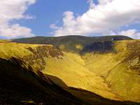 Carrifran Glen
The water features of the Moffat Hills:-
The area of the Moffat Hills is famous for its natural lochs and man made reservoirs. It has three very large reservoirs within its area that all supply drinking water to Scotland’s capital city of Edinburgh and its surrounding area. All three reservoirs are owned by the East of Scotland Water and have plenty of information about the roles they play in the supply of drinking water on tourist information boards positioned at certain points of interest along them.
With the reservoirs we will start with the most isolated one at the end of a no through road from Tweedsmuir.
 Fruid Reservoir
 Talla Reservoir
 Megget Reservoir
Fruid Reservoir
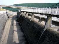
When you come off the A701 Edinburgh road drive into the village of Tweedsmuir take a right turn at the cross roads after the bridge over the River Tweed. Follow along the winding road from Tweedsmuir and you will see the vast dam of the Fruid Reservoir with its large mass of concrete overflow channels that look like a motorway flyover and typical 1960's looking control tower.
Fruid is a substantial reservoir lying on the course of the Fruid Water in the Scottish Borders. It opened in 1968 to supplement the Talla Reservoir, located 2 miles (3 km) to the northeast, in supplying Edinburgh with drinking water. There is a car park just before the dam’s access gate and you can park up here and go for various walks around the dam. Of interest if you walk across the dam and follow the road over into the next valley there is a much smaller dam and reservoir. This is a feeder reservoir that diverts water from the river of Hawkshaw Burn into Fruid. When at this dam there is a small cairn across the way in the corner of a field called Hawkshaw Castle. From Hawkshaw Castle there are on clear day’s good views of Broad Law. Back at the main Fruid dam when you look south over the waters of the reservoir the summit of Hart Fell stands clear along with many of its satellite summits. From the dam the river becomes that of Fruid Water which runs off north through the valley and on into the great River Tweed.
Heading back from Fruid to Tweedsmuir when you are back in Tweedsmuir to reach the waters of Talla and Megget reservoirs take a right turn on to the wild road that links Tweedsmuir with Cappercleuch.
Talla Reservoir
The reservoir of Talla is stacked in history. Built in the Victorian period it was such a vast project to build that it had its own railway line built to carry the building supplies and the work force. The existence of this railway is still visible today when travelling through the valley of Tweedsdale it runs along side the road and there are various disused bridges that show its course. Just near the reservoirs dam there is a fantastic building called the Victoria Lodge which was a lodgings building for the workers to stay in and I believe this is now used as a seasonal hotel for great get away country holidays.
The Talla Reservoir is in the Scottish Borders and located about a mile southeast of the village of Tweedsmuir. Extending in a northwest-southeast direction along a picturesque U-shaped valley, the reservoir has an overall length of 2 miles and is fed by the Talla Water. The reservoir was opened in 1899 and is retained behind an earth-work dam that covers an area of 121 ha (300 acres). It was designed to supply Edinburgh with water, which flows by gravity through a 28-mile pipe line known as the Talla Main. The reservoir draws its water from a catchment area of 2501 ha (6180 acres). The dam here at Talla does not look as big as the dams of Fruid and Megget but the reservoir itself snakes through the valley between the hills of Garelet on the Moffat side and Broad Law on the Manor Hills side. The reservoir of Talla is fed by Talla Water a river that starts high up in the Moffat Hills near the summits of Lochcraig Head and Firthybrig Head then running down through the valley to Talla Moss where it then drops around 100 metres in various rapids and waterfalls till it feeds into the Talla Reservoir. The other main river to feed into Talla Reservoir is that of Games Hope Burn that also starts high up in the Moffat Hills near the peat bogs of the Rotten Bottom and running of north from the water table into Talla Reservoir near the farm house of Talla Linnfoots. From the overflow of Talla Reservoir the river of Talla Water then runs north on in to the great River Tweed.
Megget Reservoir
Finally the largest of these man made water features is the vast waters of the Megget Reservoir. The dam here at this reservoir is enormous and all its control room features and pumps are hidden away from view in that they are all underground in the front of the dam. Megget has alot of differences to Fruid and Talla in that it has tourist stopping car parks with picnic spots right the way along the road. These are large open car parks which also give access for disabled people to be able to get out and take in the views across the reservoir to the Moffat Hills. When you look across the waters of Megget from Cramalt Burn where the road takes a sudden wind to cross the burn if you look across the reservoir there is a crazy land feature on the side of the small hill called Syart Law and this land feature looks like a claw was scraped down the hill side. It has no name when seen on maps but I have always known it as the Claw. See the picture below that shows what I mean. From the dam of Megget there is another car park where a circular walk can be done across the dam and down round the control systems and back up the dam on the other side. The rivers that feed into Megget Reservoir are those of Megget Water which starts on the open area near the Megget Stone and on the east side of the Talla Moss water table. The other river is that of Winterhope Burn that starts out on Winterhope Moss in the Moffat Hills near Lochcraig and runs down through the deep valley between Crimley Hill and Craigdilly. From the dams out flow, the river of Megget Water then runs south down the valley and on into the vast natural lake of St Mary’s Loch. St Mary’s Loch is also clearly visible when standing on the dam at Megget Reservoir and looking down the valley of Megget Water.
 Fruids Concrete
 Talla Valley
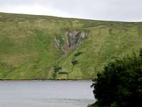 Megget The Claw
 Loch of the Lowe's
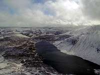 Loch Skeen/Skene
 St Mary's Loch
St Mary's Loch
"Oft in my mind such thoughts awake by lone St Mary's silent lake.
Thou know'st it well, - nor fen nor sedge pollute the pure lake's crystal edge.
Abrupt and sheer the mountains sink at once upon the level brink,
And just a trace of silver sand marks where the water meets the land."
Sir Walter Scott, Marmion.
At around 3 miles long and 40 metres deep, St. Mary's Loch is the largest natural loch in the Scottish Borders area. Only part of it from the village of Cappercleuch and on towards Moffat is within the Moffat Hills region. The views across this lake are stunning from all angles and on the still days without any wind the water is like a mirror reflecting the hills and trees. Along side St Mary’s Loch are plenty of places to park your car and enjoy walks. St Mary’s Loch is fed by many different tributary rivers but its main one is that of Yarrow Water which the source is from the east side of the water table at Birkhill then runs into the small loch of Loch of the Lowe’s. From St Mary’s Loch Yarrow Water then continues on east down Yarrow Dale and on into the river of Ettrick Water and finally the River Tweed. The other main river that feeds St Mary’s Loch is that of Megget Water from the reservoir as mentioned about in the reservoirs section.
Loch of the Lowe's
Next up stream from St Mary’s Loch is the smaller natural lake called Loch of the Lowe’s. Along side this small loch there is the Glen Café for snacks, meals and drinks on its northern shores. At weekends the Glen Café does a Bistro service in the evenings. Loch of the Lowes and St Mary’s Loch are divided by a very short stretch of running water making a small river not even 100 metres in length. This dividing river is at Crosscleuch with a very nice medieval bridge over it. As it is not named on the Ordnance Survey maps I am not sure if this very short stretch of water is part of the river of Yarrow Water. The rivers that feed into Loch of the Lowes are Crosscleuch Burn that runs off from the Ettrick Hills along with Chappelhope Burn that runs in from the Moffat Hills and finally the main river called Little Yarrow that starts up at the water table just east of Birkhill.
Loch Skeen or Skene
The natural lake that impresses most people who decide to venture out on these hills has to be that of Loch Skeen / Skene. This isolated lake stands high up on the Moffat Hills and is shadowed by the summit of Lochcraig Head and held in by the walls of Mid Craig. The lake was created many years ago when the glacial action retreated and coursed the hanging valley of Tail Burn at The Grey Mares Tail. Tail Burn is fed from Loch Skeen / Skene which is then fed from smaller tributary waters that run off the surrounding area. Loch Skeen / Skene is not the easiest to get to but a walk up to the loch from the Grey Mares Tail Waterfall car park can be done. The route up is via a steep path up the east side of the hanging valley. Once out on the upper levels near the top of the waterfalls the path is an easy trek to the shores of the loch, fantastic views across the loch to the summits of White Coomb and Lochcraig Head with the ridge of Mid Craig in the center can be seen from here. Be careful in ice and snow as the route up and down can be dangerous.
 Tweed Valley
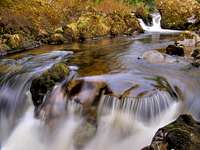
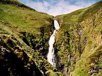 Grey Mares Tail
 River Tweed
River Tweed
The River Tweed is best known as one of the world's greatest salmon fisheries. More Atlantic salmon are caught than any river in the European Union and it has been a Mecca for anglers since the 17th Century.
But it is not for fish alone that people are drawn to the Tweed. At 98-mile's long this river being the second longest in Scotland after the River Tay, flows through some of the most beautiful and historic scenery in Britain. In fact, the Tweed forms a major part of the border between England and Scotland – a frontier which was much disputed in years gone by. Today, there are ruins of watchtowers and fortresses which add a hint of romance to the pretty borderland scenery through the Tweed Valley.
The source is at Tweed's Well, near the county boundary of Dumfries and Galloway and the Scottish Border, the river flows east joining the North Sea at Berwick upon Tweed in Northumberland. It is interesting to note that for the final four miles of its journey, the Tweed runs entirely through England.
Grey Mares Tail Waterfall
Created from the glacier that retreated off the upper levels of White Coomb, Lochcraig and the waters of Loch Skeen / Skene. The glacier cut quick and deep into the side of Moffat Dale creating the hanging valley of Tail Burn leaving behind a trail of waterfalls with the highest being the Grey Mares Tail at around 200 feet. The waterfall is situated about 10 miles east of the town of Moffat along the A708 Selkirk road. The land round the waterfalls is National Trust for Scotland owned and access to the waterfall is from a National Trust car park just off the A708 in Moffat Dale. There is a charge for using the car park unless you are of course like me a National Trust member. The National Trust also has a visitors centre on site giving lots of information to the wildlife in this area.
Red Tape:-
There is no red tape out on the hills of Scotland.The only thing I will say is respect the lower reaches of the valleys around the farms and peoples gardens.
Local Weather details:-
 What not to do...!
Always before planning any trek or venture on the mountains make a check on the weather. I am not saying everyone is stupid but there are some people that just dont think...?
The BBC 5-Day weather forecast is via this link:-
Moffat BBC 5-Day Weather
Bed and Breakfast - Accommodation and Camping:-
The area surrounding these Moffat Hills has many market towns that offer the services of hotels and bed and breakfasts etc:-These are just some links for the Moffat area:-
Moffat Bed and Breakfast GOOGLE Search:-
BedandBreakfast-Directory.co.uk ( Moffat )
Moffat Camping GOOGLE Search:-
ukcampsite.co.uk ( Moffat )
Camping is also available in the wilds of the hills but look after the countryside whilst out there.
More about wild camping by searching on this site:-
Other towns within easy reach of the Moffat Hills are as follows:-
Dumfries
Biggar
Galashiels
Hawick
Lockerbie
Peebles
Selkirk
Add these towns into a search engine such as Google also include bed and breakfast or camping in the search and the list should be endless...!
Useful Links:-
Below are a number of links for various web sites that may be of use when wishing to venture into this area.Local Councils:-
Dumfries and Galloway Council
Scottish Borders Council
Websites:-
Gazetteer for Scotland
A web site with more about Moffat
Moffat Mountain Rescue Team
Save our scenery
There has recently been news about the Devils Beef Tub a fine natural land feature of the area to have plans for a wind farm. Although I support the views of renewable energy I have to say there are the right places and the wrong places for building these sites. The plans have been put forward for 36 turbines to be built across the head of Annandale at the Devils Beef Tub and on east towards the wilds of Hart Fells western ridges. On my last visit there from Annanhead there were two tall guyed radio masts built in the wilds. I am guessing these are the wind speed monitoring and weather stations for the future telemetry purposes. I do feel this will be a real shame if the wind farm gets the go ahead. The below website gives more information about this application and also has a link for you to give your views.
Saveourscenery.org.uk
National Trust For Scotland
National Trust Scotland
www.grough.co.uk
Grough
The above link has some information on walks from the Grey Mares Tail and Moffat Dale.