
|
|
Area/Range |
|---|---|
|
|
42.38600°N / 119.3307°W |
|
|
9733 ft / 2967 m |
|
|
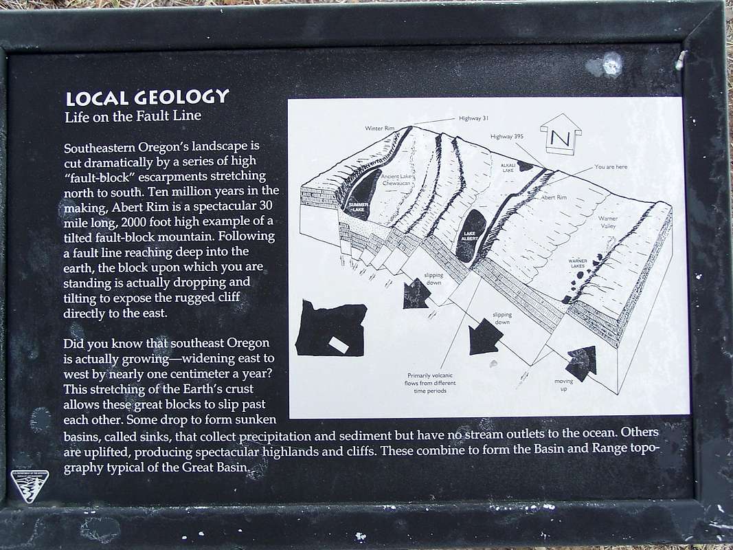
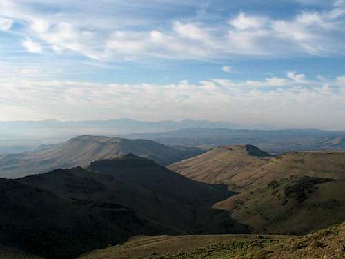
Basin and Range
Southeast Oregon is defined by fault-block mountain ranges, steep walled basins, and high isolated buttes occupying an ocean of sagebrush, juniper, and bunchgrasses. This is the land of Basin and Range in Oregon, the northwesternmost extent of America's Great Basin. Oregon's Basin and Range is the result of the east-west extension of the Earth's crust which occurs as the clockwise rotation of the Pacific Northwest pulls the southern half of Oregon apart. Being more specific, as Western Oregon is pulled away from the eastern half of the state, the continental crust in Southern Oregon is fragmented into massive blocks that behave in one of three ways: they lift leaving isolated ranges such as Hart Mountain; plunge leaving deep flat valleys such as the Alvord Desert; or tilt (sink unevenly) which results in a soaring cliff on one side and a gradually descending slope on its opposing side. This last instance is best seen at Abert Rim, with a dramatic basalt capped 2500 foot cliff on its west face, and a 1500 foot drop in elevation over the course of 20 miles on its unassuming east side. Although basin and range is primarily isolated to the southeast corner of the state in Oregon, it is quite common across the American Southwest and is most obvious in places such as Death Valley, a sinking fault block framed by uplifting ranges. For a detailed description of fault block tectonics, the following picture details how this terrain forms. This sign and many other informative placards can be found at a rest stop alongside highway 395 at Abert Rim.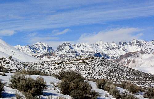
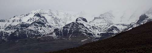
Steens Mountain - Wildhorse Ridge
Flood basalts and geologic history:
17 million years ago across much of Eastern Oregon, fissures in the Earth's crust erupted staggering amounts of basaltic magma inundating much of the Pacific Northwest beneath successive flows hundreds of feet deep. Coinciding with the advent of Yellowstone Volcanics in Western Idaho these basalt "floods" continued for several million years on and off from vents around Steens and Pueblo Mountains. In present day, signs of these flood basalts can be found along the rangetops of Southeast Oregon, especially along Abert Rim and the east face of Steens Mountain, both of which are nearly entirely comprised of flood basalts stacked one layer upon another. Steens Basalt erupting from vents near Pueblo Mountain left layers of basalt stacked up over 3000 feet thick in places along the Steens Mountain uplift. Great examples of a flood basalt vents can be found in the canyons of Steens Mountain as streaks of vertical basalt cutting through horizontal layers. Other vertical dikes can also be seen across the region, including the Big Fish Fin which can be seen from the summit of Beatys Butte. This impressive basalt feature has been revealed by the gradual erosion of surrounding terrain leaving only the hardened vertical basalt standing.
The Pleistocene Ice Age was the next era of geologic development in Southeast Oregon. It was during this time that deep U-shaped canyons were carved across the breadth of Steens Mountain. This was a much wetter and colder time, with glaciers present on Steens Mountain, Drake Peak, and Gearhart Mountain. Before the rise of the Cascade Range, which now blocks Pacific air masses, precipitation was much more prevalent in this region, meaning greater erosion rates creating canyons such as those cutting deeply across the west face of Hart Mountain. The eventual rise of the Cascades and a warming planet meant the end of glacial snowpacks in the Oregon High Desert and brought about massive accumulations of meltwater in the desert basins. Inland seas accumulated in low laying basins, in many cases reaching depths great enough to overflow into drainage systems that reached the sea. Malheur Lake overflowed into the Malheur River, Fort Rock Lake into the Deschutes, and even in this present era Goose Lake sometimes reaches depths great enough to drain into the Pit River in Northern California.
The Holocene Epoch has seen the gradual drying out of the American Southwest and Southeast Oregon. Many basins no longer contain the inland seas they once did. Fort Rock Valley, Christmas Valley, the Catlow Valley, and the Alvord Desert now only see seasonal lakes whereas they once contained large inland seas. In this region only Steens Mountain sees consistent large snowpacks whereas other high peaks such as Drake and Warner Peaks may not see snow that lasts more than a few months.
Buttes
A prominent feature of Southeast Oregon is the many buttes scattered across the basins, probably the most known example of these is Beatys Butte on the west side of the Catlow Valley near Steens Mountain. A sign of long ago volcanics, these one time lava cones and volcanoes are found at varying heights and masses across southeast Oregon. Glass Buttes near the settlement of Hampton is comprised of large amounts of multi-colored obsidian and is a popular site for rock-hounds. Watching over the small settlement of Wagontire Oregon is a trio of small but distinctive peaks visible from miles away; 5300 footers Iron Mountain, and Squaw Butte, and the larger 6513 foot Wagontire Mountain. Far to the west near Egli Rim lays Table Rock, a small but distinguished flat-topped butte. Many of these buttes unknown or unrecognized by hikers provide great beauty to the flat desertlands and reveal a variety of animal and plant life not found in the lower basins.
Two Thousand Foot Prominence Peaks:
This region is home to seven peaks with at least two thousand feet of prominence. In order of prominence these are: Steens Mountain, Pueblo Mountain, Drake Peak, Crane Mountain, Warner Peak, Blue Mountain, and Beatys Butte. Although not included on this page, the following mountains have major tributaries draining into Southeast Oregon basins and are technically considered part of this region: Strawberry Mountain, Gearhart Mountain, Paulina Peak, and Snow Mountain. Two summits in the Sheepshead Mountain Range have over 1950 feet of prominence, narrowly missing the list. Finally, Stevenson Benchmark and the West Pueblo Ridge both exceed 8000 feet of elevation and have over 1600 feet of prominence.
County Highpoints: Three county highpoints are found in the Oregon Basin. Steens Mountain is the highpoint of Harney County, Crane Mountain is the highpoint of Lake County, and BM Stevenson is the highest point in Malheur County.
The High Ranges
These are ranges that have come to define Southeast Oregon. The towering fault blocks that stand in contrast to the lowlaying basins. Each of these unique ranges feature highpoints above 8000 feet, and capture precipitation which provides the water this dry region depends on. Arranged in order of elevation of the ranges highest point, here are the highest and most popular peaks of Southeast Oregon.Steens Mountain

Kigermann
At nearly 10000 feet, oregon's ninth highest peak is glacially articulated Steens Mountain, the best known of the fault uplifts in southeast Oregon. This massive fault block is tilted west-northwest, leaving a high eastern rim with a 9733 foot summit, that gradually descends northwesterly towards the Harney Basin near the town of Burns. To the east of Steens Mountain is the Alvord Desert, a block that has plunged leaving a 7000 foot offset between the lowest point of the Alvord Desert Block (deep beneath the sediments of Alvord Lake) and the summit of Steens Mountain. To the southeast is the soaring walls of the Catlow Rim carved with canyons from ice age runoff into a vast inland lake that occupied the Catlow Valley. Evidence of this lake can be seen along the east side of the Catlow Valley in its many sand dunes. The Malheur Wildlife Refuge is a narrow strip of lush marshland surrounded by sagebrush desert that can be found at the NW base of Steens Mountain. This verdant river basin recieves vast amounts of snowmelt from the upper reaches of the mountain via the Donner und Blitzen River.
Steens Mountain Features:
Steens Mountain has a number of unique locations. Most prominent is the many glacial canyons including the Kiger Gorge seen in the image at left from the Kiger Gorge overlook. On the horizon is the canyons sidewall, a point known as KigerMann highlighted by the notch referred to as "Big Nick", where the Kiger Glacier breached the summit ridgeline of Steens Mountain spilling into the Alvord Valley. Other major canyons include Wildhorse Canyon extending south from Steens Mountains summit, and both Indian Creek Canyons which extend west from the summit.
Other named locations on and around Steens Mountain include the southern highpoint, Alvord Peak, the most prominent of The Peaks subrange. Midway down the east face from the summit is Devine Peak, a 500 foot basaltic pinnacle, most easily reached from the Alvord Desert below. At 7181 feet is BM Stonehouse overlooking Juniper Lake on the north end of the massif. As for the name Steens, the fault block was originally called Snow Mountain, but its name was changed in honor of Major Enoch Steen who pursued and skirmished against indians on the peak in 1860. Thanks to its high elevation and relatively large winter snowfalls, a number of lakes can be found on and around Steens Mountain. Most prominent of these are Fish Lake on the Steens Mountain Loop Road with its popular campground, and Mann Lake a popular sportfishing location at the north end of the Alvord Desert.

Access: 60 miles south of Burns on Highway 205 is Frenchglen, a small town which has a store, gas station, and bed & breakfast. On the south end of Frenchglen is the Steens Mountain Loop Road, a well maintained gravel road that leads to a series of high elevation overlooks on the Steens Mountain crest. Up to the Wildhorse Lake Overlook this is a well maintained gravel road that many sedans should be able to handle. From this road you can easily reach either the summit of Steens Mountain or Kigermann with short ridge walks. Although you can nearly drive to the summit of the mountain, many hikers opt to climb Steens Mountain via the trail that leads up Big Indian Gorge.
Pueblo Mountains
South beyond the Steens Mountain Range and The Peaks lies the solitary giant Pueblo Mountain and to the west the Pueblo Mountain Range.
Pueblo Mountain
Although the range runs north south for 30 miles very few points are named, and there are no prominent lakes or reservoirs. the few named points include BM Fields, Ladycomb Peak, and Strawberry Butte just across the border in Nevada. In the image below is the West Pueblo Ridge seen from just east of the Long Hollow Pass. The West Pueblo page has pictures of other peaks in the mountain range.

Access: The North Ridge route on Arizona Creek is one of the quickest and easiest routes to summit Pueblo Mountain or the West Pueblo Ridge. Traveling up Arizona Creek will lead to Stergen Meadows, a mountain ringed valley which provides many great camping locations. The road up Arizona Creek is very rough, do not attempt travelling up here without robust tires and four-wheel drive.
Crane Mountain and the Northern Warner Mountains
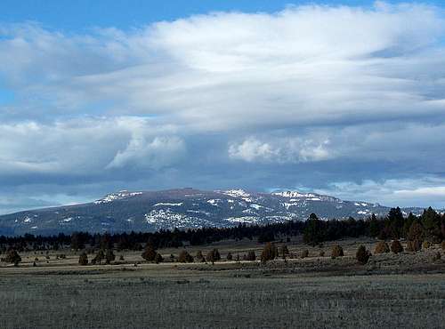
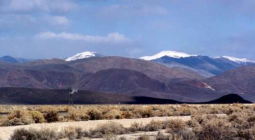
Seen from west of Lakeview in the image below is the highpoint of the Warner Mountains in Oregon and the third highest peak in Southeast Oregon at 8456 feet. In Oregon the Northern Warner Mountains are a massive uplift overlooking Goose Lake on a scale that only Steens and Pueblo Mountains can exceed. However to the south across the California border where the Goose Lake Basin and Warner Mountains extend is the range's highpoint; Eagle Peak, the dominant mountain of the interstate region at 9892 feet.

Eagle Peak in Northern California
Along this NW border of the Great Basin the Warner Mountains are definitely the dominant fault block range, and its highest peaks lie in the South Warner Wilderness in Northeast California along the Nevada border. In the south this massive escarpment like Steens Mountain tilts westward with a dramatic east face. The Northern Warner Range doesn't feature a true escarpment like Abert Rim to the North or the Southern Warners. Fault Block Tectonics are at work here, but the Northern Warner block is not a large singular mass that is tilting as distinctively as its northern and southern neighbors. The west side of the range is definitely more dramatic, and upper Crane Mountain itself possesses the characteristics of a tilting fault block. Contributor Bubba Suess offers a brief description of the Northern Warner Range HERE on the Mount Vida page.
In addition he has posted historical and geologic information on the Warner Mountains page. For a look at the high peaks of the Warner Range and other mountains in that vicinity check this LINK for an interactive map of the Eagle Peak area.
Drake & Light Peak
A tight cluster of highpoints can be found where the backsides of three prominent fault ranges meet: Abert Rim's southeast flank, the western flank of Lynchs Rim, and the fragmented northeastern flank of Warner Rim. It is at this point where a group of mountains rise high above the landscape to elevations ranging from 7500 to 8400 feet. The highest of these at 8407 feet is Drake Peak. Unlike many of the peaks on this page, these lay in the transition zone between coniferous alpine forest typical of Northern California and the drier Oregon High Desert. Bands of whitebark pine are found on north facing slopes with stands of old growth ponderosa surrounding sagebrush meadows laying below the high peaks. In the image below is Light Peak and Drake Peaks as viewed from the Plush Cutoff Road.

Twelvemile Peak
Other Features:
The mountains in this cluster include; Twelvemile, McDowell, and Crook Peaks, all over 7600 feet in height. Drake Peak is named after Colonel John M Drake, an officer involved in battles againsht the Snake Indians in south Central Oregon. As for the name Warner, which is used for a wide variety of features in this region originates from Brevet Captain William Horace Warner, believed to have been killed in the Warner Valley in 1849 in an indian ambush (Oregon Geographic Names, page 636, 1952). Warner was part of an expedition sent to explore the upper Pit River in California who ended up exploring much of Southern Oregon's Great Basin country.
Access:
The Drake Mountain area is accessed via NFD 3615 which is a paved forest road exiting north off of Highway 140 - 10 miles west of US395 near Lakeview, Oregon. This road recieves large amounts of snow in the winter and is a popular snowmobiling destination.
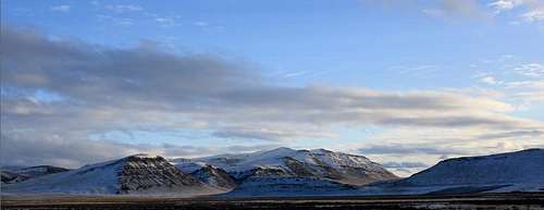
Hart Mountain and Warner Peak
Hart Mountain is a flat-topped uplift thats protected on all sides by steep sided cliffs broken by deep gorges.
Warner Peak
Hart Mountain Features:
The highest point on Hart Mountain is Warner Peak, located on the east side of the uplift. Although Warner Peak is little more than a bump on massive Hart Mountain it is recognized as a 2000 foot prominence peak. Like Steens Mountain this uplift is carved by deep gorges along its west face. These canyons are typically several thousand feet deep each and with soaring vertical walls. Unlike the Steens Mountain Gorges these however tend to be carved by erosion rather than glaciers. Other features along the Hart Mountain uplilft include Poker Jim Ridge and the Orejana Plateau, northern segments along the same escarpment. Hart Mountain is the entire uplift seen in the image below taken from the North Shore of Hart Lake. Hart Mountain was originally called Warner Mountain, but was renamed after the brand used by a local ranch. At some point the misspelling of Hart instead of Heart became accepted.
Access: The Warner Peak page getting there directions will lead you to the easiest access for the absolute summit of Hart Mountain. A longer approach to the summit can be made via the DeGarmo or Hart Canyons on the west side of Hart Mountain. From the mouth of either of these canyons to summit expect 3500 feet of elevation gain and a full day of scrambling.

Oregon Canyon and Trout Creek Mountain Ranges

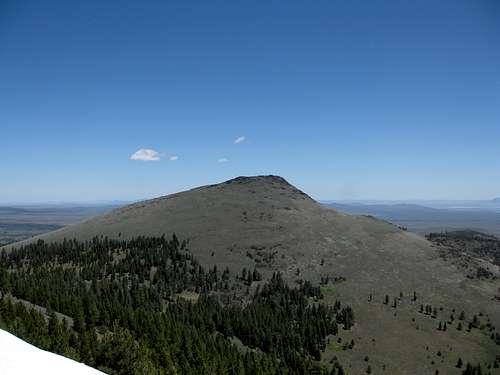
Blue Mountain
The least known of Oregon's Fault Blocks:
Two of the least seen and recognized ranges in Oregon are the Trout Creek Mountains and the Oregon Canyon Mountains on the Nevada border east of Fields and Denio. Although barren at first sight, these broad topped ranges are highlighted by their deep willow and aspen lined canyons hiding small riparian streams. The two most significant streams found here are Trout Creek and Whitehorse Creek, which both drain into dry desert basins. Most surprising is that both landlocked creek systems support trout and beaver populations. Above the canyons, Mountain Mahogany blankets many high ridges that can rise from the low valley floor to elevations above 8000 feet. Surprisingly the bulk of these long ridge lines in both mountain ranges are above 7000 feet.
Trout Creek Mountains:
The Trout Creek Mountains is a north tilting uplift that crosses the state line with some peaks laying in Nevada. Typically seen from the road connecting Fields and Denio, much of the High Trout Creek Range is hidden from view unless one travels up the Whitehorse Ranch Road and south into the mountains. The highest point in the Oregon Trout Creek Mountains is an unnamed point sitting above the Sherman Field; however less than 2 miles away just over the state line is the absolute highest point in the range, Orevada View Benchmark. At 8506 feet this range highpoint has 3500 feet of prominence. Seen below, the Mahogany Ridge along Big Trout Creek on the Whitehorse Ranch Road.

Oregon Canyon Mountains:
Like a shorter version of Steens Mountain, the Oregon Canyon Mountains are a fault block tilted to its west with a high eastern crest. The highest point in the Oregon Canyon Mountains is BM Stevenson on a lone eastern ridge at 8027 feet. This fault block is bisected by the Whitehorse Creek Canyon, at 1600 feet in depth. Whitehorse Creek Canyon is not glacial like those found on Steens Mountain as the canyons in this range tend to be narrower, and with more vertical sidewalls. Furthest east and sitting alone along the west side of Highway 95 is Blue Mountain, seen above at left.
Other Uplifts
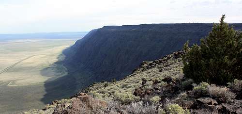
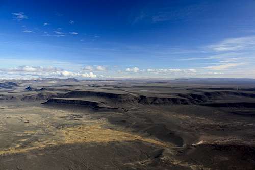
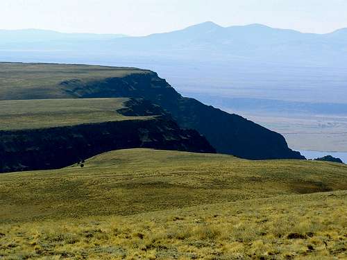
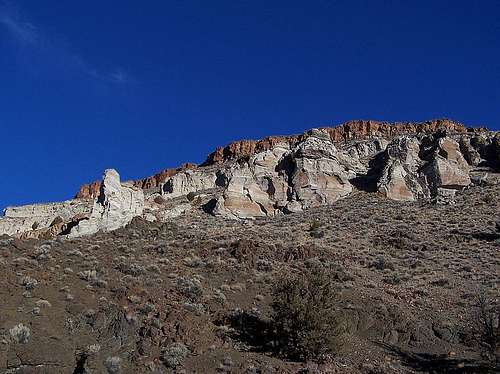
Abert Rim:North America's longest fault escarpment is Abert Rim. This giant fault block tops out at 7543 feet and stretches non-directly over 40 miles from the Sherman Valley near Drake Peak far north to the Christmas Valley - Wagontire Cutoff Road. While nearly all of Abert Rim's vertical west face could be considered desert, much of its gradual east face hides a large old growth ponderosa forest including Colvin Timbers. The Drake Peak Range sits atop the southern end of Abert Rim, and at nearly 7000 feet, Juniper Mountain rests atop the northern end of the rim. Seen below is Lake Abert at left and the rim at right.

Poker Jim Ridge
Poker Jim Ridge: Seen at right is Poker Jim Ridge roughly 1500 feet lower in elevation than neighboring Hart Mountain. While many of the fault blocks of Southeast Oregon feature vertical rims along the upper portions of their escarpments, Poker Jim Ridge is almost vertical basalt from top to bottom. This is one of the most dramatic vertical faces you will find anywhere in Oregon, and the best place to see it from is the Warner Valley Overlook on the road that leads up the west side of Hart Mountain to the antelope refuge. According to Oregon Geographic Names the nearby town of Plush was named for a local Paiute celebrity who could not pronounce the word flush. The book does not name the person, but it is quite likely he was Poker Jim.
Winter Ridge:
State Highway 31 skirts the eastern base of this prominent rim. In 2002 the Winter Fire ravaged this forested scarp leaving it a largely barren on the east face and blackened along its high western ridgeline. The highpoint of Winter Ridge is 7762 foot Slide Mountain at the southeastern end of the rim, the summit can be driven to. Freemont Point near the mid-point of Winter Ridge can also be reached by vehicle and is a popular viewpoint overlooking the Summer Lake Basin. Captain John C. Fremont named Winter Ridge based on conditions along the rim crest, snowy and miserable in contrast to the good weather in the basin below, which he subsequently named Summer Lake. Many Oregon locations bare Fremont's name, a captain with the topographical engineers of the US Army. Below, Winter Ridge as seen from the west shoreline of Summer Lake.


Lynchs Rim
Lynchs Rim: A distinctive rim seen along the Adel - Plush Highway. This rim rises 2000 feet from Crump Lake to its highest point less than one mile to the west. No developed trails exist to the summit of Lynchs Rim as most of the summit plateau is private ranchland. Seen at right; Lynchs Rim viewed from the shore of Crump Lake. South of Adel along the same fault line as Lynchs Rim is the South Warner Rim.

Egli Rim
Egli Rim: Notable as the first obvious tall rim you will see when travelling from Central Oregon into the Basin and Range territory. Not nearly as impressive as nearby Winter Ridge, Egli Rim does have a litte more than 1000 feet in relief from valley to crest. Specifically this rim lays on the east side of the Silver Lake Basin. Egli Rim is seen in the image below at right.
Hawks Valley Peaks:
Hawks Mountain, Lone Mountain, and Acty Mountain are a trio of 7000 footers ringing the remote and desolate Hawks Valley. Hawks Valley is a small sagebrush depression on the east side of the Pueblo Mountain Range. There are no mountain pages for these peaks on summitpost, and not much informtion can be found with regards to this area outside of the book 75 Scrambles In Oregon which contains route information for Hawks and Lone Mountains. This area is accessed via a very poor 4x4 road that travels south through Funnel Canyon just west of Fields, a good place to refuel before venturing into this region.
Catlow Rim: The vertical southwestern edge of the Steens Mountain uplift where the Roaring Springs can be found erupting from seemingly indistinct hillside. Near the site of the Roaring Springs, Bighorn Sheep can frequently be seen alongside or crossing the highway as water and feed are abundant here. The four hundred thousand acre Roaring Springs Ranch headquarters located at the base of the Catlow Rim at the Roaring Springs. Much of the Catlow Rim is carved with deep and very steep sided canyons that stretch back into the interior of the Steens.
Guano Rim: Highway 140 from Lakeview to Denio cuts up the side of this indistinctive 1000 foot tall uplift from the Guano Valley on the Oregon - Nevada border. Where the road crests Guano Rim a hang-gliding launch can be found. A cluster of peaks can be found on the north end of the rim, including Beatys and Lone Grave Buttes.
Sheepshead Range
Diablo Rim:
The Diablo Rim can be found between Summer Lake and Lake Abert. Diablo Rim lacks the elevation of Winter Ridge, and the distinctive face of Abert Rim, but it does have a unique series of north-south trending fault lines cutting across its summit plateau that can only really be seen from the high points of Sharp Top and Diablo Peak. Vegetation and water are very sparse on and around Diablo Rim.
Sheepshead Range:
Northeast of Steens Mountain the terrain is highly dissected by fault scarps. The resulting uplifts are called the Sheepshead Range, with highpoints in the south and north. The range is dominated by several buttes, primarily Sheepshead BM in the north, Coffin Butte at the center of the range, and Mickey Butte in the south. Laying in the rainshadow of Steens Mountain, precipitation is scant here, and the land is dominated by cattle grazing, antelope and little else.
The Large Basins
Southeast Oregon is
Catlow Valley
The Alvord Desert
The driest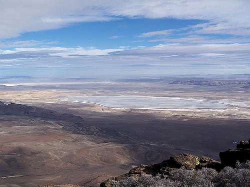
Alvord Lake in the Alvord Desert Basin
Other playas in this basin include Tum Tum Lake directly east of Pueblo Mountain, Alvord Lake east of Andrews, and Mickey Basin which lies northeast of Mickey Butte. In late winter you may see water accumulate around the edges of several of these playas depending on snowpack and rain.
The small community of Fields lies at the southern end of this basin, with Denio just 22 miles further south just on the Nevada side of the border. The Alvord Ranch was founded in this basin by John Devine, following the establishment of the Whitehorse Ranch in 1869 Oregon's Great Basin Country. Ranching remains the primary source of income in the Alvord Desert Basin, although it appears more retirees and seasonal residents are trickling in along the edges of the valley.
Catlow Valley
The largest basin in this region is found southwest of Steens Mountain. The Catlow Valley was the one time location of a large Pleistocene lake and is now dry other than some small stock ponds along its east side and shallow seasonal lakes primarily found in the south. The ghost town of Blitzen thrived here for a short time when conditions were wetter in the early 20th century, now only irrigation allows any sort of activity in this area. The activity in particular is extensive cattle ranching based out of the Roaring Springs Ranch. This is an interesting article about the manager of the Roaring Springs Ranch and the issues that ranch faces as presented by a ranching magazine. The book Oregon's Great Basin Country states that the Roaring Springs Ranch was once part of Peter French's ranching operations, but is now owned by a corporation.The Catlow Valley is bounded by the Steens in the East and stretches west towards Hart Mountain. Beatys Butte lies on the west side where the Guano Rim stretches northward out of Nevada.
Lake Chewaucan Basin
This U-shaped basin now home to Summer Lake in the west and Lake Abert in the east once was filled to a great enough depth that both lakes merged into a singular Great Basin sea referred to as Lake Chewaucan. This lake covered an area of 461 miles to a depth of 375 feet, a series of geological markers along the shores of Lake Abert and Summer Lake attest to the history and geological development of this area.Summer Lake is a small alkaline lake located in the basin between Winter Ridge and Diablo Rim. Fed by meltwaters from Winter Ridge, but not any high volume rivers this lake is not as large as its eastern or southern neighbors. The dominant town here is Paisley, with a population of 250 its located where the Chewaucan River exits the Fremont Range. As the hub for the gigantic ZX Ranch, Paisley has a gas station and a small store. Summer Lake occupies the salt flats seen below Winter Rim in the picture below.

Lake Abert is the third largest alkaline lake in North America. The aforementioned Chewaucan River flowing from the Fremont Range drains into Lake Abert providing it with a more steady source of water than Summer Lake receives. In the past Brine Shrimp were dredged from the lake and sold as "sea monkeys". Lake Abert Basin is bordered on the west by the Diablo Rim and Coglin Buttes. Significantly, Lake Abert is an extremely popular destination for birdwatching in late summer and early fall months.
Harney Basin
The drainage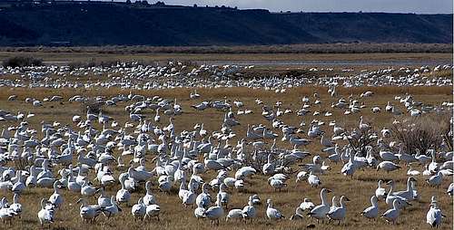
Malheur National Wildlife Refuge in the Harney Basin
Peter French began ranching operations here and in the Catlow Valley in the 1870's, leading to the eventual establishment of Frenchglen, named after himself and his wife's maiden name. The town of Frenchglen is the hub of the southern Harney Basin, with several popular destinations in close driving proximity including Diamond Craters and Peter French's Round Barn.
Warner Valley
West of Hart Mountain,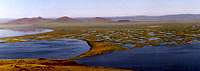
Warner Valley
Canyons of Southeast Oregon
Over the course of the last few million years the flat-topped uplifts of Southeast Oregon have been carved by deep canyons, many over a thousand feet deep, and some over 3000 feet. The vast majority of these gorges were created by erosion, but in the case of Steens Mountain, glaciation created the regions most spectacular canyons. Most identifiable of these is the Kiger Gorge as seen from the overlook where visitors get their first look at a desert cirque from the summit ridge of Steens Mountain. While Kiger Gorge is the best known of the canyons in the Oregon's Basin and Range territory, many other scenic canyons can be visited and many of them can be hiked. Listed below is which canyons are associated with their uplifts, and photos and directions as available.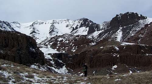
Steens Mountain West Side:
These are the big dogs of Southeast Oregon, and some of the deepest canyons in the Pacific Northwest. Each of these following canyons originate along the summit ridgeline and contain tributaries that drain into the Malheur National Wildlife Refuge.
Kiger Gorge
Big Indian Gorge
Little Indian Gorge
Steens Mountain East Face:
Some of the most dramatic canyons in southeast Oregon are found along the seldom visited east face of Steens Mountain. Although shorter than the west face canyons, the headwalls can be over 3000 feet in height from mountain summit to canyon bottom. These canyons drain onto the Alvord Desert only a few miles from their headwaters, however they typically do not run dry and do hide populations of small rainbow trout and beaver.
Pike Creek Canyon
Big Alvord Creek Canyon (this is the north sidewall devine rock)
Cottonwood Creek Canyon
Little Alvord Creek
Hart Mountain:
From the summit of Warner Peak at the head of Hart Canyon to the alluvial fan where the canyon dumps into the Warner Basin is an elevation difference of over 3000 feet. DeGarmo is the most easily accessed and hiked of these canyons, and hides a few small waterfalls and a rough trail. Potter and Hart Canyons are shorter and without trails, but feature more spectacular sidewalls.
DeGarmo Canyon
Hart Canyon
Potter Canyon
Oregon Canyon Mountains:
As stated above this tilted fault block is bisected by the Whitehorse Creek Canyon. Less than 2000 feet deep, this is still a well defined gorge producing enough water to sustain trout and beaver populations.
Whitehorse Creek
Oregon Canyon Creek (This picture by Dean shows Fall Creek Canyon at the head of Oregon Canyon Creek)
Antelope Creek
Trout Creek Mountains:
Big Trout Creek
Significant Logistical Centers
Southeast Oregon is probably the least civilized area in the pacific northwest, and as such finding gas and food can be difficult. The most significant settlements are Burns and Lakeview.
Great Horned Owls of Fields
Burns is located on highway 395 on the northern edge of the Oregon Desert(population 3000) and offers a few lodging and dining establishments. This town is a good jumping off point for Steens Mountain and Malheur Wildlife Refuge which both lay to the southeast. Burns is 130 miles E-SE of Bend on highway 20.
Lakeview on the border of California is the next largest town with a population of 2500. Mountains near Lakeview include Crane, Drake, and Hart Mountains. Abert Rim can be found approximately 20 miles to the north of Lakeview. For those of you that enjoy roadtrips Lakeview is 216 miles southeast of Bend on highway 31, 140 miles south of Burns along highway 395, or 100 miles east of Klamath Falls on Highway 140.
Fields is located on the western edge of the Alvord Desert at the junction of Highway 205 and the East Steens Mountain Road. Not much of a town it does feature the Fields Station, which is a gas station, store, a couple motel rooms, and a small cafe that serves some great burgers and milkshakes. Unlike some of the other gas stations in the region, gas can always be found here. Fields is a jumping off point for Steens Mountain, the Pueblo Mountains, the Trout Creek Mountains, and Oregon Canyon Mountains. Free BLM literature for the region is available in the store.
McDermitt, Nevada is located on US Highway 95 just across the border. Nearby peaks include BM Stevenson, Blue Mountain, and south across the border Granite Peak, the Humboldt County highpoint.
Gas can be found at the following locations:
Burns, Lakeview, Fields, Denio, Adel, Plush, Frenchglen, Jordan Valley, McDermitt, Juntura, Christmas Valley, Valley Junction, Silver Lake, Summer Lake, and Paisley.
Seen Below: Fields and Pueblo Mountain

Resources - Notable Books of Southeast Oregon and External Links
Oregon's Great Basin Country by Denzel and Nancy Ferguson - Although out of print nearly two decades now, this book has a listing of hikes and offers historic information you may not find elsewhere. This is the Southeast Oregon Bible for anyone that enjoys hiking and exploring this corner of the state.Geologic Field-Trip Guide to Steens Mountain Loop Road, Harney County, Oregon Published by the USGS in 2001.
Hiking Oregon's Geology by Ellen Morris Bishop
In Search of Ancient Oregon by Ellen Morris Bishop - Essentially a coffee table book, but also a good source of information for the geologic history of Oregon. This book spends a lot of time discussing the basalt floods and faulting, but doesnt necessarily spend a lot of time on individual mountains.
Roadside Geology of Oregon by David D. Alt and Donald W. Hyndman Not a good source of information for Southeast Oregon, but it does spend a little time on Abert Rim and Steens Mountain.
75 Scrambles in Oregon Barbara Bond's book features 12 mountain routes in Southeast Oregon with 3rd class or easier routes to the summit.
Oregon Desert Guide Although many of the route descriptions in this book are vague, it does have cover a lot of area. The author Andy Kerr is somewhat of a renegade in Southeast Oregon thanks to what ranchers see as his hardline environmental views, and he spends a significant amount of the book discussing environmental concerns.
Hart Mountain Antelope Refuge Homepage
Oregon Natural Desert Association
Burns BLM page
Oregon Geographic Names: Lewis A McArthur - This book has been around since 1928. Originally compiled by Lewis L McArthur over 80 years ago, his son took over the effort and has added information ever since. I have referenced the 1952 edition for this page. I encourage anyone interested in Oregon history to pick an edition of this book up.
The following people have contributed some of the great mountain and route pages to summitpost and are still active users. Each of these people have provided information that has been inspirational and informative in the creation of this and all of my pages.
Dean
cjwhat
Dennis Poulin
RPC
Weather
Burns:
Owyhee Area Honeycombs

Lakeview:

Other Peaks of Southeast Oregon
Mickey Basin Benchlands
Gearhart Mountain
Hart Mountain Plateau
Looking South from BM Stevenson
Sheepshead in Spring
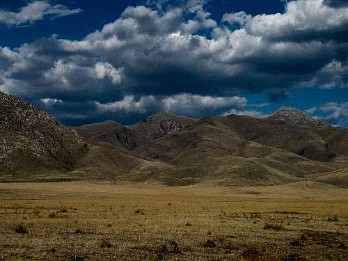
A storm sweeps over The Steens
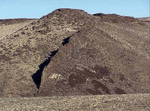
The Big Fish Fin
Greaser Canyon
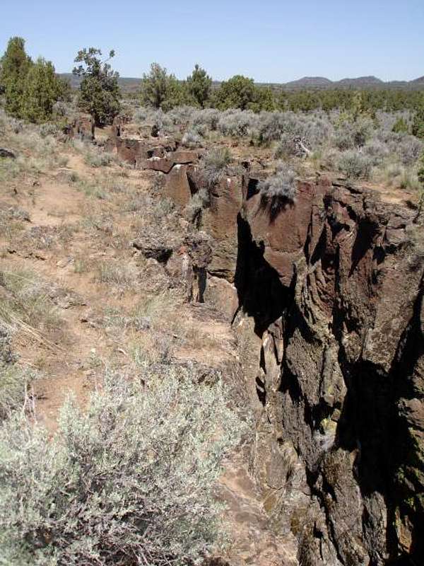
Crack in the Ground
The purpose of this list is to act as a reference for mountains that haven't been listed in the categories above or do not have summitpost pages. It is my goal to have at least one picture of each significant SE Oregon peak attached in some manner to this page. In other words this is the section to check if you are curious what peaks such as Hawks Mountain or Lone Grave Butte might look like. As I get the opportunity this list will be expanded providing pictures become available.
For this section the boundaries of this region will be defined as they are in the book, Oregon's Great Basin Country. The western limits roughly follow the border of Lake County including Hager Mountain atop Winter Rim and south through the Fremont Range including peaks east of Gearhart Mountain. The eastern extent more or less follows highway 20 north of Burns and east to Juntura, then southeast to the Idaho border including the West Owyhee Uplands.
| Mountain | Elevation | Prominence | Image |
| Steens Mountain | 9733 | 4383 |  |
| KigerMann | 9348 | 508 |  |
| Pueblo Mountain | 8635 | 3042 |  |
| Crane Mountain | 8456 | 2356 |  |
| West Pueblo Ridge | 8420 | 1640 |  |
| Drake Peak | 8407 | 2557 |  |
| Light Peak | 8325 | 505 |  |
| Twelvmile Peak | 8144 | 704 |  |
| Stevenson BM | 8027 | 1617 |  |
| Warner Peak | 8017 | 2127 |  |
| Beatys Butte | 7918 | 2055 |  |
| Chick BM | 7879 |  | |
| Crook Peak | 7834 | 654 |  |
| Devine Rock | 7782 |  | |
| Slide Mountain | 7762 |  | |
| South Steens Rim | 7698 | 1078 |  |
| McDowell Peak | 7654 | 334 |  |
| Abert Rim | 7548 |  | |
| Hawks Mountain | 7234 | 1344 |  |
| BM Stonehouse | 7220 |  | |
| Hager Mountain | 7185 | 1455 |  |
| Mahogany Butte | 7140 |  | |
| Alvord Peak | 7132 | 1312 |  |
| Acty Mountain | 7019 | 869 |  |
| Red Mountain | 6989 |  | |
| Lynchs Rim | 6932 | 1262 |  |
| Lone Mountain | 6903 | 1320 |  |
| Juniper Mountain | 6679 | 1441 |  |
| Lone Grave Butte | 6582 |  | |
| Wagontire Mountain | 6513 | 1778 |  |
| Poker Jim Ridge | 6464 | 684 |  |
| Glass Buttes | 6390 | 1640 |  |
| Riddle Mountain | 6352 | 806 |  |
| Mickey Butte | 6294 | 1964 |  |
| Sheepshead Range HP | 6289 | 1979 |  |
| Coglan Butte | 6209 | 1378 |  |
| Diablo Peak | 6147 | 1237 |  |
| Little Juniper Mountain | 6145 | 1155 |  |
| Buckskin Mountain | 6090 | 1260 |  |
| Peak 6090 - Mann Lake Butte | 6090 | 1400 |  |
| Whitehorse Butte | 6076 | 1126 |  |
| Flagstaff Butte | 6029 | 1059 |  |
| Sharp Top | 5740 |  | |
| Oregon End Table | 5501 |  | |
| Iron Mountain | 5380 | 1069 |  |
Other Nearby Peaks of Basin & Range - Denio / McDermitt Area
As there are no area and range pages for Northern Nevada in the Denio and McDermitt areas, here is a brief overview of a few of the points of interest in the Denio area.Immediately southeast of Denio Junction is the Bilk Creek Mountains, a smallish range maxing out at 8400 feet. Terrain here is very similar to the Trout Creek Mountains. Very few of the peaks are desirable hiking destinations, but the willow lined road up Wilder Creek to the range highpoint is truly gorgeous in the spring and offers easy access to one of Nevada's many P2K summits.
Bilk Creek Mountains highpoint - P2K
Continuing the Steens Mountain - Pueblo Mountain fault line south leads to massive Duffer Peak in the Pine Forest Range. Duffer Peak is a ninety four hundred foot peak with over four thousand feet of prominence. Unlike Southeast Oregon's nearby high ridges, this mountain is blanketed in whitebark pine at high elevations.
Granite Peak - 9732 feet - P4K
Further south of Duffer Peak is the Jackson Range, including King Lear Peak, and the ranges crest, Jackson Range Highpoint. Hidden around the highpoint of the range is a beautiful high elevation plateau with a number of awe-inspiring pinnacles and subpeaks. Laying to the west between the Jackson's and Duffer Peak is the bleak and very dry Black Rock Desert.
Looking east towards McDermitt is the Santa Rosa Range with its 9733 foot highpoint Granite Peak. Another notable mountain here is Santa Rosa Peak at 9701 feet, also a P2K.
Finally; the Owyhee Canyonlands lay east and northeast of Oregon's Great Basin. This region in itself is a large basin with several notable fault block ranges draining into it; however none of the peaks or ranges listed on this page drain into the Owyhee River in any significant amounts.
Oregon Field Guide Videos
Here are links to the individual segments from Oregon Public Broadcasting's Oregon Field Guide. A lot of great video of the high desert here, and a lot of information.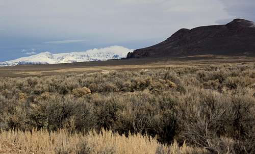
Summer Lake Wildlife Refuge
Mickey Hot Springs
Borax Lake Chub
Steens Mountain Archeology
B24 In Pueblos
Ranching on the Alvord - Branding Day
Summer Lake Archeology
Warner Uplands Archeology
Steens Mountain in Winter
Warner Wetlands
Lahontan Cutthroat Trout in Whitehorse and Willow Creeks
Brine Shrimping on Abert Lake
Hart Mountain Antelope Refuge
Pueblo Range Hike
Steens Mountain Climate
Rafting the Middle Owyhee