
|
|
Mountain/Rock |
|---|---|
|
|
42.30350°N / 120.149°W |
|
|
8325 ft / 2537 m |
|
|
Overview
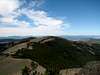
Light Peak is in a small knot of summits exceeding 8,000 feet in the Warner Mountains. The other high peaks in the immediate vicinity are Twelvemile Peak, Drake Peak, and Crook Peak; although Crook Peak is not over 8,000 feet. Light Peak consists of basalt uplifted as a fault block. The fault block which uplifted this small group is more extensively eroded than other eastern Oregon fault blocks such as Winter Rim and Hart Mountain.Light Peak is one of the most accessible high peaks in Oregon. It is 15 miles off of Highway 140 northeast of Lakeview. The first 8 miles of road is paved. The dirt road portion, which is a pretty good road for the region, goes all the way to the summit.
Views from the summit include the three surrounding peaks previously listed, Hart Lake and Hart Mountain to the northeast, the Warner Mountains to the south, Mt. Shasta to the southwest when visibility is good, and numerous mountains and distinctive fault blocks to the west and northwest.
The ‘Drake Peak’ lookout is actually on the west summit of Light Peak which is about 100 feet lower than the east summit.
 |
Getting There
Find Lakeview on a road map of Oregon. It’s at the south end of the state near the center for those of you unfamiliar with Oregon. Just north of Lakeview Highway 140 heads east. Follow Hwy 140 east for 10 miles, then turn left (north). The sign says ‘Mud Creek Campground’. Follow the road all the way to Mud Creek Campground which is adjacent to Bull Prairie. The distance is approximately 8 miles. Take a right on road #019 one-half mile past Mud Creek Campground. The sign says ‘Drake Peak 6’. Road #019 ascends from west to east toward the top. The road forks after six miles. Turn right and drive until you run out of road after about 300 yards. You’re at the top.If you turn left at the fork you will end up at the 'Drake Peak' lookout on the lower (8,222 feet) west summit.
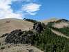
The road to the summit does not require 4WD, although it does get progressively less 'road-like' at the top. The 4WD track in the picture descends the east side of Light Peak into the saddle which connects to Drake Peak. You will need 4WD to get out if you descend that track.
 |
Red Tape
You have to love eastern Oregon. The Winema and Fremont National Forests were administratively combined in 2002 and in 2005 the only site which requires a Northwest Forest Pass is the Mt. McLoughlin trailhead. In summary, there is no red tape.When To Climb
Any time there isn’t significant snow on the ground you can drive to the summit. 4WD is desireable if there is any moisture on the ground. There is a ski area at Warner summit on Hwy 140, so Light Peak does get some snow. It would, however, be an excellent 7 mile snowshoe trek if you can get to Mud Creek Campground which is at an elevation of 6,500 feet. |
Camping
Mud Creek Campground has a pit toilet and a handpump well. There are about 10 camp sites and it is lightly utilized outside of holidays and hunting season. Mud Creek has good fishing. I recommend a Royal Coachman for the eastern brook trout and a caddis fly for the native Redband Trout.If the campground is too low for you the Drake Peak Lookout at 8,222 feet can be rented for $25 per night. Price is current in 2005.