
|
|
Mountain/Rock |
|---|---|
|
|
46.34290°N / 7.31449°E |
|
|
Hiking, Scrambling |
|
|
Spring, Summer, Fall, Winter |
|
|
9961 ft / 3036 m |
|
|
Overview
The Arpelistock (3036 m / 9960 ft) is a mountain near the Sanetschpass / Col du Sanetsch. The Arpelistock is located in the western part of the Bernese Alps. The mountain is on the border of the Swiss Cantons Bern and Wallis. The Arpelistock is located between two more prominent mountains, Les Diablerets and the Wildhorn.Due to the vicinity of the Sanetsch Road it is possible to reach the summit on a day trip. The most common ascent starts at the Col du Sanetsch and follows the Arête de l'Arpille and the south face slopes. The Arête de l'Arpille is a rather wide ridge which offers some excellents views towards the Pennine Alps. Another possibility to reach the summit is by starting at the Geltenhütte, which is located at the northeast side of the mountain. The mountain can be recommended to experienced mountain hikers or, in winter, to backcountry skiers. Be sure to reach the summit in sunny weather, because the summitview in stunning.

Getting There
To Col du Sanetscha) Southside: There's a road all the way to the Col du Sanetsch from the south side. I would not recommend to go by foot. Take the bus from Sion or go by car. Parking lot and Busstop at the Col du Sanetsch.
b) Northside: Starting point is Gsteig. Take the Cable car from Gsteig to the Sanetschlake. From the Sanetschlake along the road (in southern direction) to the Col du Sanetsch. Either by car, bus or on foot.
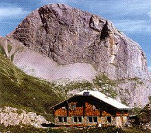
To the Geltenhütte (thanks to Alpenkalb)
Starting point is Lauenen 1241 m, bus from Gstaad, hotel, store, restaurant. There are 2 paths to the hut.
a) Road to the lake (restaurant). From there follow the path near the creek. Sometimes used in winter on safe days. 3 hours.
b) Soon after Lauenen, the path quits the road and stays on the right (east) side of the valley. Partially exposed, ladder. 3.5 hours.
Routes
There are probably several routes to the summit of the Arpelistock. I will only describe two of them, which are far most common. Other routes, are dangerous or not interesting.Normal route from Col du Sanetsch
Start at the eastside of the Col du Sanetsch. Follow the Arête de l'Arpille untill P. 2652 m. On this point the path splits. Take the path left, northern direction, which will lead you through the south face slopes of the Arpelistock. The last part is well marked (blue/white marks). The last wide couloir can be filled with snow and has some steep steps.
Time: 2 hours
Difficulty: T4 (Alpine Hiking, see this page for information about the SAC Hiking scale)
Normal route from the Geltenhütte
Head south towards the Rottalvalley on clear tracks. Reach the wide pass at 2685 m. Continue by heading in southwest direction to point 2949 m, which is on the northwest ridge of the Arpelistock. Then along the ridge to the summit.
Time: 3 - 4 hours
Difficulty: T5


Maps and Guidebooks
Map 1:25 000:- SAC Map: 1286 St-Léonard
- SAC Map: 1266 Lenk
Map 1:50 000:
- SAC Map: 263 Wildstrubel
- SAC Map: 273 Montana
Online Maps:
Guidebook:
- SAC Guidebook: Clubführer Berner Alpen 1 - Sanetsch bis Gemmi, D. Anker, T. Kopp, J. Muller, W. Munter, P. Schmid, ISBN: 3-85902-231-8
To order SAC Maps: www.toposhop.ch
To order SAC Guidebook: www.sac-cas.ch
External Links
Geltenhütte SAC 2003 mUeli & Marianne Stalder
Rossweidli
CH-3704 Krattigen
Phone (hut): +41 (0)33 765 32 20
Homepage:www.geltenhuette.ch
Hotel du Sanetsch 2047 m
Fam. Guy-Noel Dumoulin
Route du Col du Sanetsch
CH-1965 Saviese
Phone (hut): +41 27 395 56 56

Homepage:www.hotel-restaurant-sanetsch.ch
Other useful links:
WSL Institute for Snow and Avalanche Research SLF - Avalance Bulletin
Weather Forecast - Detailed weather forecast
Railroad information - Railroad schedule
Bus information - Postbus schedule
Saviese - Tourist Office Saviese