
-
 11311 Hits
-
 96.51% Score
-
 60 Votes
|
|
Mountain/Rock |
|---|---|
|
|
43.96510°N / 115.1199°W |
|
|
Elmore |
|
|
Hiking, Scrambling |
|
|
Summer, Fall |
|
|
9704 ft / 2958 m |
|
|
Overview
 Arvals Peak from Blacknose Mtn
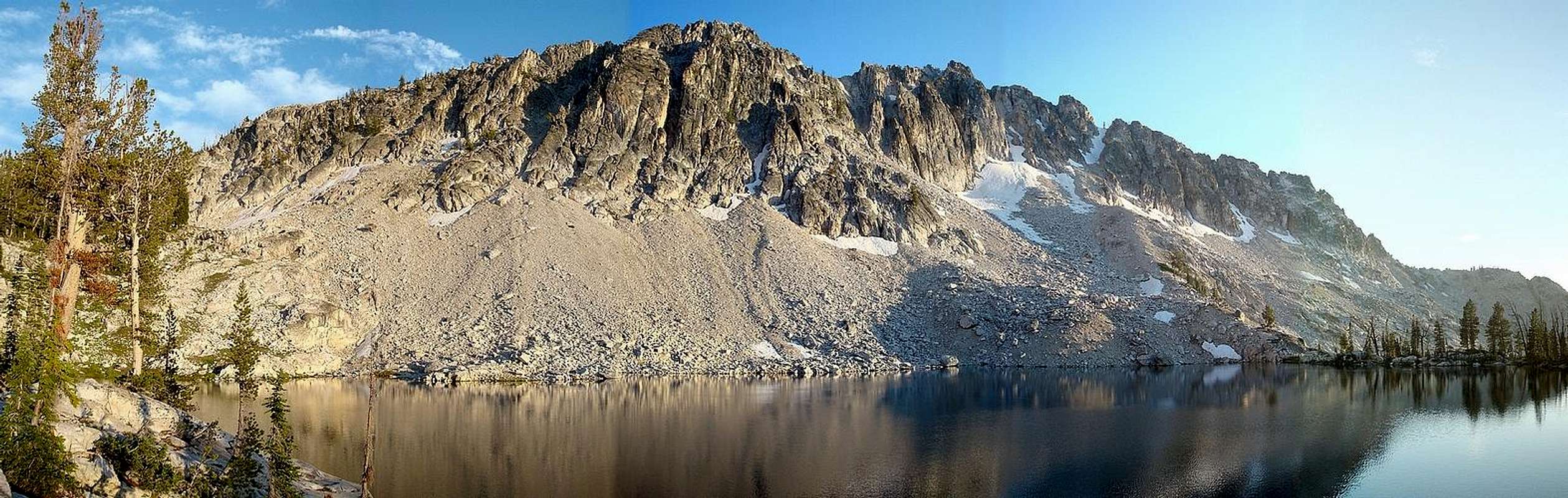
The Sawtooth Mountains are home to some of the most spectacular scenery in all of Idaho. As a result, the Sawtooths have become the most popular range in the state, with most visitors concentrated in the eastern and northern portions of the range. But for those who want to experience great Sawtooth scenery with a bit more solitude, the southern end of the range offers some excellent alternatives. Arvals Peak is found deep within the southern Sawtooths, near the headwaters of the Queens River. The summit is a commanding position to take in the view of the surrounding terrain. It is a fairly short scramble from where the trail crosses the Queens Divide at Queens Pass, but the summit sees very few visitors since it is about 16 miles from the nearest trailhead.
Although not particularly prominent compared to some of the other nearby mountains, Arvals Peak does have a nice pyramid shape to it. Probably the most impressive physical feature of Arvals Peak are the cliffs that make up its north face, creating an outstanding backdrop for campsites at both Pats Lake and Arrowhead Lake. It is also an attractive peak when viewed from the east, while climbing the trail towards Queen’s Pass, which is the highpoint of the “Queens River Loop”, a great 4-6 day backpacking route.
  |
Different mountains get climbed for different reasons. Often it’s a peak’s aesthetic qualities that draw climbers to its summit, or a challenging route to test our abilities. Arvals Peak has a little of each of these attributes, but the main reason to head for the summit of this peak is clearly the views. The scenery is nothing short of exceptional, with far-reaching views in all directions. Azure Lake lies to the west, with the deep Johnson Creek drainage fading off in the background. To the south lies an excellent view of the Queens Divide, an attractive string of jagged peaks. The formidable Mount Everly is located to the east, with numerous lakes visible below. Lastly, the view that will keep your attention the longest is to the north, with the Rakers just visible behind Blacknose Mountain.
 Mount Everly & Eastern Sawtooths Mount Everly & Eastern Sawtooths |
 Rakers & Blacknose Rakers & Blacknose |
 Azure Lake & Johnson Creek Azure Lake & Johnson Creek |
The Queens Divide
| ||||||||||||||||||||||||||||||||||||||||||||||||
 The Queens Divide
Arvals Peak is located near the midpoint of what Tom Lopez refers to as “The Queens Divide”, which is found in the southwest corner of the Sawtooths. This north-south running divide is made up of a string of peaks that separate the Queens River and the Little Queens River in the south. The divide then continues north to form the barrier between Pinchot Creek and Fall Creek, before terminating at the South Fork Payette River. There are many impressive peaks located along Queens Divide, including Nahneke Mountain, Browns Peak, and the infamous Rakers. The Rakers are unquestionably the most eye-catching feature on Queens Divide. They are seldom seen, but are subject to much lore and legend. North Raker is particularly striking, and has seen very few ascents since it was first summitted by mountaineering legends Fred Beckey and Pete Schoening in 1949 (Lopez pg 204). The other peaks that make up Queens Divide may not be as noteworthy, but any number of them are certainly worthy destinations all on their own.
Arval L. Anderson
 1927 photo of Arval L. Anderson
 Summit Marker
The peak is named for Arval L. Anderson, who created the first detailed map of the Sawtooths in 1927. Arval went on to a very successful Forest Service career, but one of his first assignments was a mapping project that covered almost 200,000 acres (over 300 square miles). Since this is some of the most rugged terrain in the state, the mapping project lasted 5 months, from mid June until mid November. Arval's surveying party consisted of his brother Joel, who served as his primary field assistant, his wife Maysel, and a horse packer who handled the stock and took care of the cooking.
Arval used the plane table method to create a topography and drainage map of the area. In a 1983 interview he did with Al Brady as part of the “Forest Service History Series”, Arval describes his mapping equipment as a “24 inch by 31 inch plate table mounted to a tripod” and “an alidade with an eight-power telescope with cross hairs and a level for reading vertical angles and a straight edge base”. Completing the mapping project required a combination of skills. Anderson had the technical knowledge to do the distance and position calculations, and the artistic ability to sketch the topographic and drainage features free hand. But more impressively, he had the wherewithal to rough it in the wilderness for five months, without the benefit of modern amenities, amongst some of the most rugged terrain you can find anywhere. Those who have been to the southern Sawtooths can certainly appreciate what it would take to live up to this challenge. Arval and his party pulled this off, even without a map to guide them.
Arvals Peak was one of Anderson’s preferred positions for triangulation because of its central location amongst the surrounding peaks. It is also a bit more accessible than other nearby peaks, which is a good thing when you consider the weight of the instrumentation (plane table, alidade, jar of cement, bronze tablets, etc.) that had to be hauled up to a highpoint to be used for triangulation. Arval had a definite personal affection for this particular peak, and he passed this fondness on to his family. They are currently working towards an “official” name classification for Arvals Peak. Obtaining this status is always a bureaucratical challenge, and is even more challenging within a wilderness area. But the naming of a peak after an individual who made such a contribution to the area would seem to be a worthy act.
Getting There
Driving Directions
There are a few different driving choices to reach the Queens River trailhead from Boise. People often follow the road past Arrowrock Dam and then up the Middle Fork of the Boise River. This may be a somewhat shorter distance, but it's much more dirt road driving and isn’t the fastest route. Instead, take the Edna Creek option to save yourself at least 30 minutes each way.
 Route Map
 Northeast Ridge
 Arrowhead Lake
From Boise, follow Highway 21 for about 33 miles north to Idaho City, then continue another 18 miles north on Highway 21, over Mores Creek Summit, to the marked turnoff for Edna Creek. If coming from the North, then its about 15 miles from Lowman to get to this point. The highway is full of curves from either direction so plan for extra time. From here, you follow a series of dirt roads from Highway 21 to the Queen’s River trailhead near Atlanta. Follow the Edna Creek Road along the Crooked River to Willow Creek, then up and over Willow Creek Summit and down to the North Fork of the Boise River. Next go east up the North Fork to Trail Creek. Continue up and over Swanholm Summit and down to the Middle Fork of the Boise River, and continue east towards Atlanta. Just after the Queen’s River Campground, turn left (northeast) to reach the Queens River trailhead. This description makes it sound harder than it really is. Pretty much just follow the signs to Atlanta, and it’s pretty straightforward.
Overall it is about 57 miles (18 highway, 39 dirt) from Boise to the trailhead, which will take just over 2.5 hours each way.
The Approach
The shortest route (still almost 16 miles and 5000 feet elevation gain, one way) to reach Arvals Peak is via the main Queens River. From the Queen’s River trailhead, cross the river then turn right (northeast). The trails starts off in Ponderosa Pine forests then crosses the river a couple times (wading shoes recommended) before climbing through groves of Chokecherry bushes on its way towards sub-alpine meadows along the upper Queens River. Follow the trail to the headwaters of the Queens River, west of Mount Everly. Watch for the Pat’s Lake trail fork about 13.5 miles from the trailhead, then climb to the west for 2 more miles to “Queens Pass” at just over 9200’ elevation. Along the way you’ll pass some beautiful unnamed lakes and some excellent views of Mount Everly. The first unobstructed view of Arvals Peak will greet you at Lake 8696’.
Northeast Ridge Scramble
From “Queens Pass”, leave the trail and scramble the last half-mile and 500’ up the northeast ridge of Arvals Peak. Its mostly straightforward Class II scrambling, with an occasional Class III move here and there. The easiest going is found on the south side of the ridge, but it's more fun and better views to try to stick with the ridge top where possible. The highlights involve a couple of spots with some very exposed views of Arrowhead Lake, almost one thousand feet below to the north.
Camping
 Pats Lake
 Arrowhead Sunset
 Arrowhead & Pats Lakes
 Trail View
 Arvals Peak from Blacknose Mtn
It is a very long approach with many sights to see along the way, so a multi-day trip is likely, and a backpacking loop is highly recommended. Potential campsites along the Queens River Loop include: Nanny Creek, Queens River headwaters, the lakes east of Arvals Peak, Arrowhead Lake, Pats Lake, Johnson Lake, Browns Lake, and Scenic Lake.
Camping and amenities (picnic tables, fire rings, outhouse) are also available at the Queens River Trailhead, or just down the road at the Queens River Campground.
Red Tape
This hike is located in the Sawtooth Wilderness Area, please observe the local regulations.Mountain Conditions
The summer climbing season in the Sawtooths is typically from July until the snow flies in October. It is feasible to go earlier in the year, but be prepared for numerous high-water crossings of the Queen’s River along the way, as well as lingering snow in the high country. I suppose a winter ascent is feasible, but would be very challenging due to the long approach.- Sawtooth National Forest - NF Current Conditions.
- NOAA Pinpoint Forecast – Weather.
- Idaho Outdoors Forum – Message board monitored by many local climbers.
Guide Books
There are a handful of guidebooks available that include information on the southern Sawtooths. Here are some useful ones: | Idaho: A Climbing Guide by Tom Lopez – This is the leading mountaineering text for the state, with a route description for Arvals Peak and numerous others in the southern Sawtooths. |
 | Backpacking Idaho: From Alpine Peaks to Desert Canyons by Douglas Lorain – Lots of multi-day trip recommendations throughout Idaho, including details on how to tackle the Queen’s River Loop. |
 | Trails of the Sawtooth and White Cloud Mountains by Margaret Fuller – The most comprehensive guidebook for the area. It includes detailed route descriptions for the Queens River Loop and numerous other hikes nearby. |
External Links
- Arvals Peak on Lists of John - Stats, maps, and more.
- Dave’s Hiking Page - Queens River Loop trip report.
- Arvals Peak on ACME Mapper - Interactive map with Arvals Peak in the cross-hairs.
- Plane Table Mapping - Details on the process used in this mapping technique.