

-
 40807 Hits
-
 93.35% Score
-
 42 Votes
|
|
Mountain/Rock |
|---|---|
|
|
44.15990°N / 115.0616°W |
|
|
Boise |
|
|
10190 ft / 3106 m |
|
|
Overview
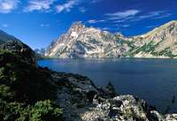
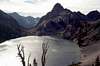
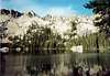
Mount Regan is probably the most photographed peak in the Sawtooth Range. It's striking north face sits at the south end of the very scenic Sawtooth Lake. The easiest way up the peak involves a classic Class 4 scramble over an exposed ledge. Regan sits just 1 mile southwest of Alpine Peak and offers exceptional views of the entire range, particularly the Warbonnet area (Monte Verita Ridge). A well maintained trail winds it's way across the east side of Sawtooth Lake and around the east and south sides of Mt. Regan, making the area a popular summer season destination hike.
Mount Regan (pronounced Ray-gen, like the former president) was named after Timothy Regan, an Idaho pioneer who got his start in Silver City, then moved to Boise in 1889. He went on to become one of the most prominent and influencial men in Boise.
Here are the routes on Mt. Regan:
1) Southeast Ridge (Class 3-4) - Most popular approach- See Routes for more detail.
2) Lower East Face (II 5.5) - At the south end of Sawtooth Lake near Lake 8489 contour around the northeast base of Mt. Regan and find the snow couloir. The first part of the couloir is the hardest part and the nature of the couloir changes near the top to snow and broken ledges. Exit the couloir onto the Southeast Ridge Route. The couloir climb is 3-5 pitches.
3) North Ridge (II 5.3)- At the south end of Sawtooth Lake ascend the slopes toward a prominent notch that separates the mountain from the ridge. Rappel down into the notch and then climb the notch wall to the summit
4) Northwest Ridge (Class 5)- From Point 9399, west of Sawtooth Lake or East of Trail Lakes follow a complex and tower studded ridge toward the summit with several rappels and easy 5th class moves to get up and over the rock towers.
Mount Regan was first climbed in 1934 by Robert and Miriam Underhill, guided by local rancher, butcher, dairyman, miner and mail carrier Dave Williams.
 |
 |
 |
 |
Getting There
Road Approach
2 miles northwest of Stanley, Idaho go west onto Iron Creek Road for 3.8 miles until you reach the Iron Creek campground and trailhead.
Hiking Approach
Follow the well marked and maintained trail from Iron Creek Trailhead for 5.5 miles until you reach Sawtooth Lake. Along the way you will pass Alpine Lake at 3.3 miles.
Other approaches options come from the GrandJean Trailhead via Trail Lakes or North Fork of Baron Creek. These approaches are longer, but less crowded.
 |
 |
 |
Red Tape
There are no hiking, backpacking or parking regulations or fees. Backcountry Campfires are prohibited in several areas including Sawtooth Lake. Drive in campsites are fee based.
October 2010: Summit Register was missing since July (replaced by me). Same for Alpine Peak. The summit register bandit strikes again!
When To Climb
Standard climbing season June through October Conditions may vary greatly. There are reports of winter visits to the Sawtooth Lake area via ski or snow-shoe.
Nearby Stanley, Idaho Climate Data:
| Jan | Feb | Mar | Apr | May | Jun | Jul | Aug | Sep | Oct | Nov | Dec | Annual | |
| Average Max. Temperature (F) | 27.0 | 33.7 | 42.5 | 50.3 | 59.9 | 68.4 | 78.7 | 78.4 | 68.6 | 56.6 | 38.1 | 26.0 | 52.4 |
| Average Min. Temperature (F) | -0.5 | 0.3 | 9.7 | 20.3 | 28.3 | 33.9 | 36.0 | 34.0 | 27.2 | 20.6 | 12.0 | -0.8 | 18.4 |
| Average Total Precipitation (in.) | 1.64 | 1.33 | 1.02 | 1.02 | 1.17 | 1.16 | 0.59 | 0.59 | 0.78 | 0.92 | 1.46 | 1.55 | 13.24 |
| Average Total SnowFall (in.) | 16.9 | 13.2 | 10.2 | 3.4 | 0.9 | 0.2 | 0.0 | 0.0 | 0.4 | 1.7 | 10.4 | 14.6 | 71.9 |
| Average Snow Depth (in.) | 18 | 20 | 15 | 6 | 0 | 0 | 0 | 0 | 0 | 0 | 2 | 8 | 6 |
Camping
Camping
- There are many drive-in campsites at the Iron Creek Trailhead
- Backcountry camping is easy to find at Alpine Lake or Trail Lakes (Sawtooth Lake has limited spots)
Mountain Conditions
Sawtooth National Recreation Area
http://www.fs.fed.us/r4/sawtooth/recreation/recreport.htm
Stanley Web Cam
http://www.ruralnetwork.net/~dpinney/
External Links
- Sawtooth Nat Rec Area Info
Sawtooth Nat Rec Area Info - Stanley Web Cam
Generously provided by a resident there
asmrz - Jun 20, 2020 12:24 pm - Hasn't voted
The descent is not easy to findIf you climb a route OTHER than the Regular SE Ridge, it would be very prudent to check the SE ridge descent beforehand. Once you get to the summit via any of the North routes, it is very difficult (if not impossible) to find the descent if you have not been there before. You can descent the complete South gully down, but it is very long way (5+ miles) from there to you tent at Sawtooth Lake (just ask us)...If anyone has GPS points for the SE Ridge, please do others a favor and post them here.
Super Dave - Jan 29, 2021 8:33 pm - Voted 10/10
Re: The descent is not easy to findYes, definitely agree. During my second climb of Regan, we descended the wrong route and got cliffed out. Fortunately, we are able to climb back up and find the correct descent route.