-
 20129 Hits
-
 88.61% Score
-
 27 Votes
|
|
Mountain/Rock |
|---|---|
|
|
43.99364°N / 114.93529°W |
|
|
Custer |
|
|
Hiking, Mountaineering, Scrambling |
|
|
Spring, Summer, Fall |
|
|
10125 ft / 3086 m |
|
|
Overview

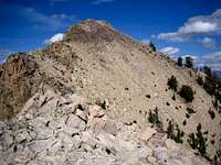
Imogene Peak is the north guardian to the spectacular Yellow Belly / Farley / Toxaway Lake valley. This peak is one of the more accessible and easy summits to reach in the range and can easily be done in a half day. It has exceptional views of Parks Peak (the south guardian to the valley), the Imogene Lake basin, and the Snowyside Peak area. It's summit reaches above 10,000 feet and contains the remnants of an old triangulation tower and 2 benchmarks. The summit ridge of Imogene is the easternmost point on a long, complex, and interesting ridgeline that could be scrambled from the Toxaway / Imogene Divide Trail at 9255 feet. Along this ridge are many unnamed, yet impressive rock towers including Point 9934 and Point 9773.
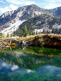
Just northwest of Imogene Lake is the upper reaches of the spectacular Hell Roaring Valley and contains one of the larger back country lakes in the range. Imogene Lake sits just south of the Finger of Fate, one of the top rock climbing towers in the Sawtooths. Just northwest of Imogene Lake lies The Arrowhead, one of the Sawtooths most challenging trad climbs. Mt. Cramer sits just to the south of The Arrowhead and is clearly visible from the summit of Imogene. The north side of Cramer contains one of the best kept secrets: the longest rock route in the range at ~ 20 pitches of solid rock. The long approach and other nearby attractive climbs have kept this under wraps for years.
No peak in the Sawtooth except perhaps Observation Peak (the only one with a trail to the summit) is easy to scramble up, but Imogene offers the rare opportunity to get above 10,000 feet with relatively few route finding issues, a short approach, and no technical obstacles. Other peaks that might fit this criteria include Abe's Armchair and Copper Mountain. The other 113 recognized mountains in this range are considered more difficult in one aspect or another.
Routes
South Slopes (Class 2-3)- the most straight forward way to the summit leaves the trail just north of Farley Lake. Follow the steep south slopes around the various rock fins. The rock is surprisingly solid in many spots. Follow the strip marked on the map as without vegetation, just east of the drainage that goes down to Farley Lake. Recent avalanches have left the topography of these slopes changed, but near the summit ridge it becomes all rock. Follow the ridge northeast until the true summit is obvious. The last 100 feet look difficult from this angle, but it's no more difficult than Class 3.
From Yellow Belly Trailhead: 4.3 miles and 3234 feet gain (one way)
East Ridge (Class 3)- from the area about 0.60 miles WSW of McDonald Lake, follow the drainage that runs perpendicular to the main valley. Follow this drainage roughly toward the northwest. A obvious boulder field (shown on the USGS quad and accurate still) is the area to aim for. From the boulder field, turn and climb west, staying just north of the rocky ridge which is just the extreme eastern extension of Imogene Peak.
From Yellow Belly Trailhead: 3.5 miles and 3185 feet gain (one way)
Descent- The easiest descent is the east ridge if done properly.

Getting There
Check the road conditions at: Idaho Transportation Department
Camping

Camp spots or primitive camping can be found virtually anywhere
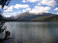
- There are many camp spots along ID-75 and around Pettit Lake
- Backcountry spots are easy to find, but some regulations exists in regards to campfires
- Good Bivy Spots are found near Farley Lake, the flat area ENE of the summit, and near Imogene Lake
Sawtooth National Recreation Area
Conditions and Season
Conditions may vary greatly. Access is typically from May to October.
The Sawtooth Valley can be one of the coldest areas in the nation during the winter. Negative readings are common. Snowfall can vary and occur at any time. Summer days can still be hot, but you'll probably never experience 90 or above, especially once you get up higher.
Nearby Stanley, Idaho Climate Data:
| Jan | Feb | Mar | Apr | May | Jun | Jul | Aug | Sep | Oct | Nov | Dec | Annual | |
| Average Max. Temperature (F) | 27.0 | 33.7 | 42.5 | 50.3 | 59.9 | 68.4 | 78.7 | 78.4 | 68.6 | 56.6 | 38.1 | 26.0 | 52.4 |
| Average Min. Temperature (F) | -0.5 | 0.3 | 9.7 | 20.3 | 28.3 | 33.9 | 36.0 | 34.0 | 27.2 | 20.6 | 12.0 | -0.8 | 18.4 |
| Average Total Precipitation (in.) | 1.64 | 1.33 | 1.02 | 1.02 | 1.17 | 1.16 | 0.59 | 0.59 | 0.78 | 0.92 | 1.46 | 1.55 | 13.24 |
| Average Total SnowFall (in.) | 16.9 | 13.2 | 10.2 | 3.4 | 0.9 | 0.2 | 0.0 | 0.0 | 0.4 | 1.7 | 10.4 | 14.6 | 71.9 |
| Average Snow Depth (in.) | 18 | 20 | 15 | 6 | 0 | 0 | 0 | 0 | 0 | 0 | 2 | 8 | 6 |


external Links

Latest Avalanche Report (Sawtooth Area)
http://www.avalanche.org/~svavctr/
National Weather Service Current Forecast for Stanley:
http://newweb.wrh.noaa.gov/total_forecast/index.php?zone=idz018&county=idc037&wfo=pih&dgtl=1&lat=44.21139&lon=-114.945Sawtooth Web Cam can give you a good idea of the conditions in the area:
http://www.ruralnetwork.net/~dpinney/SNOTEL site gives latest snow depth readings:
http://www.wcc.nrcs.usda.gov/snotel/snotel.pl?sitenum=845&state=id