Overview
![From the West]() Avalanche Mountain from the West, with Powerline Pass to its right
Avalanche Mountain from the West, with Powerline Pass to its right
At 5050± feet, Avalanche Mountain is one of the higher peaks of the Chugach Front Range that provides the backdrop for the city of Anchorage. Because much of the approach is bikeable, it makes a relatively easy half-day outing. The routefinding is straightforward and there's not much exposure or risk of knocking rocks on your friends, making this a good summer objective for neophytes. It's far enough back to give nice views into the remote upper Ship Creek drainage. Despite the pleasant surroundings, though, you won't encounter any crowds on this mountain.
Avalanche Mountain used to be known as "Powerline Pass Peak," and the summit register still carries that name.
Trailheads
From the west: The easiest starting point is the Glen Alps trailhead. From central Anchorage, take the Seward Highway south to O’Malley Road (or take the Minnesota Bypass, which turns east and becomes O’Malley Road). Drive about two miles past the Alaska Zoo and turn right onto Hillside Drive. After exactly one mile, take a left onto Upper Huffman Road. At the top of this, turn right onto Toilsome Hill Drive and continue to the large, paved, well-signed parking lot at the trailhead. The trailhead is at about 2250 feet, close to treeline.
Glen Alps suffers from a serious shortage of parking, and parking on the road outside the gate will net you a $200 fine (enforcement is vigorous). If you arrive too late to find a spot, an alternative west-side trailhead is
Upper Huffman, signposted from Upper Huffman Road. It adds about 700 feet to your ascent. At both of these trailheads there is a $5.00 parking fee, unless you have an annual sticker. It’s one of those envelope-in-the-box jobs, so bring exact change.
From the south: Avalanche Mountain is also conveniently reached from the Indian Creek Trailhead. From approximately Milepost 103 of the Seward Highway south of Anchorage (Alaska Highway 1), turn north on Ocean View Road by the Turnagain House Restaurant and drive this about a mile to its end, elevation 400 feet. There is free parking here.
Approaches and Standard Route
![View Eastward]() Eastward into the Ship Creek drainage from the summit
Eastward into the Ship Creek drainage from the summit
Start by going to Powerline Pass. From either the Glen Alps Trailhead or the Indian Creek Trailhead, the pass is about six miles.
The Glen Alps approach is the easiest. From the trailhead, take the well signposted "Powerline Access" link to the Powerline Road and follow this dirt track eastward all the way to the 3500-foot pass. There is a 1300-foot elevation gain, most of which is quite gentle. Most people with any sort of mountain bike can comforably cycle three to four miles of the distance, and strong mountain bikers will be able to bike the whole way. This
link takes you to a map of the route.
From the Indian Creek Trailhead, follow the Indian Valley Trail for about 200 yards and then turn left across a steel bridge onto the powerline route. There is a 3100-foot elevation gain to the pass, making this much more arduous than the Glen Alps approach. The route is brushy and is difficult to bike, especially uphill; most will prefer to hike it. For an excellent map covering all of this approach, click on
this link.
Once in Powerline Pass, turn northward and gain the main south ridge heading toward the crest. Easy scree takes you to a false summit at about 4700 feet; from there, about half an hour of tedious but easy scrambling along the southeast side of the crest (class 2) leads to the top. Don't go by the description in the popular book "50 Hikes in Alaska's Chugach State Park," which erroneously describes the ridge only as far as the first false summit.
Camping
There is decent camping by the lakes just west of Powerline Pass. The area isn't quite pristine--you've got the powerline, as well as a few jeep roads marring the tundra--but it's a nice enough place to spend a sunny evening. Campfires are not permitted and very large groups will need a permit; otherwise, there are no formalities.
Winter Trips
![Winter View]() East face from Bidarka Peak, January
East face from Bidarka Peak, January
If traveling in winter or spring, the Indian Creek approach is almost always the safer one, as the area just west of Powerline Pass--the Glen Alps side--often has high avalanche risk. The Indian Creek side is not avalanche-free, though, so know what you are doing if traveling over snow to this destination.
You can see avalanche advisories for Turnagain Pass in the eastern Kenai Mountains (about 25 miles southeast of Avalanche Mountain) by going
here. The conditions are by no means identical, but the wind, temperature, and snowfall history of the two areas are often somewhat parallel.
Links
Chugach State Park
Live temperature and wind at weather station near Glen Alps (1300')
Glen Alps weather history and stats (2250')

 18078 Hits
 89.39% Score
 29 Votes
 Avalanche Mountain from the West, with Powerline Pass to its right
 Eastward into the Ship Creek drainage from the summit
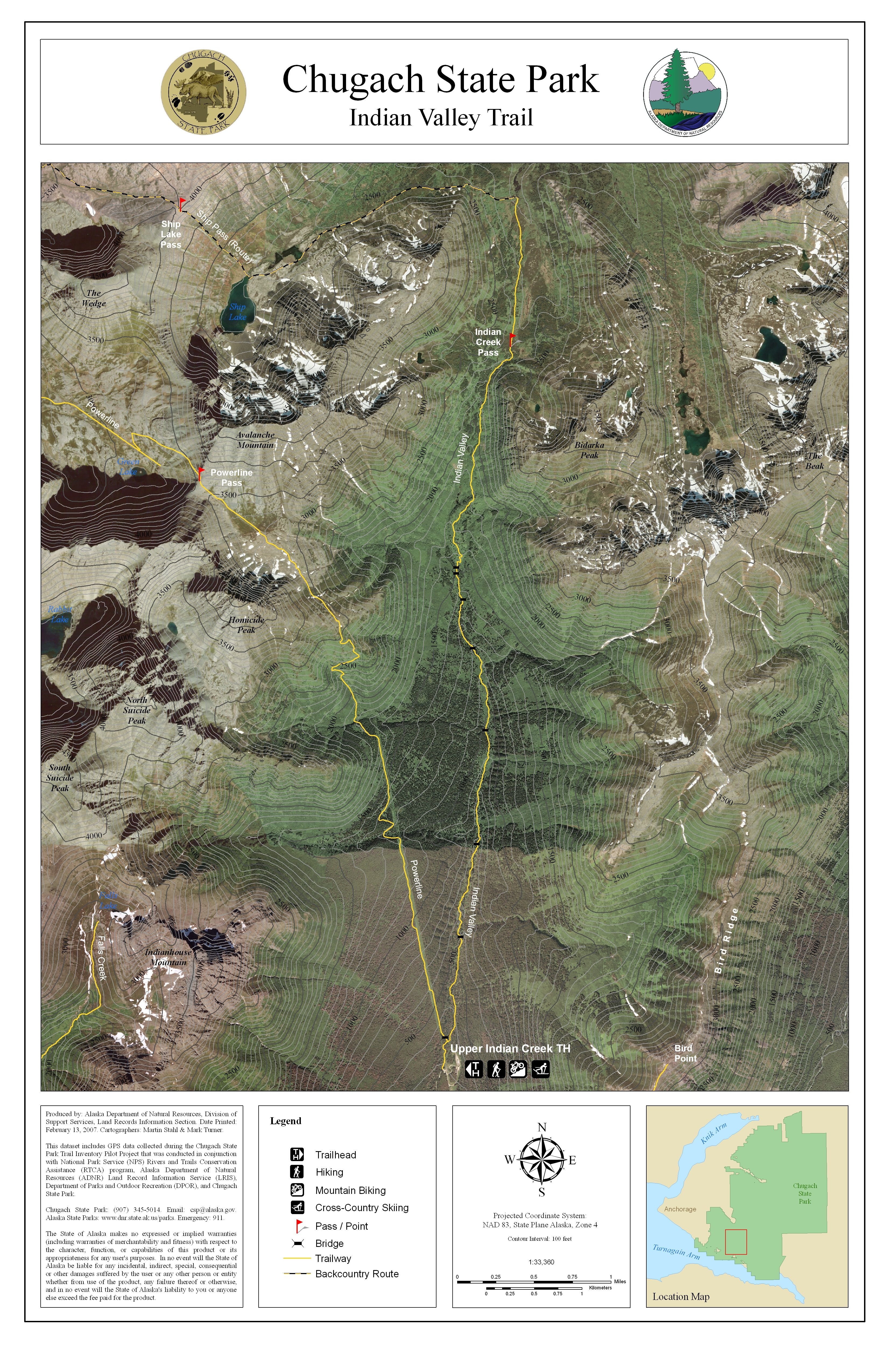
 East face from Bidarka Peak, January
Steve Gruhn - Jan 12, 2011 4:19 pm - Voted 10/10
Summit ElevationThe summit elevation on the first edition of the Imus Geographics Chugach State Park Map is inaccurate. The accurate summit elevation is 5050 feet plus or minus 50 feet. I talked with Dave Imus about this, and in subsequent editions he agreed to omit the elevation because there was no basis for the 5056-foot elevation he initially stated on the first edition map.
chugach mtn boy - Jan 16, 2011 4:49 pm - Hasn't voted
Re: Summit ElevationI hesitated to act on your correction because your suggestion here that the 5056 elevation was not merely unconfirmed, but had not basis at all and thus was something Imus pulled from thin air, seemed kind of extraordinary. But I have attempted contact Imus and there has been no answer, so I will take your word for it.
Steve Gruhn - Jan 16, 2011 5:25 pm - Voted 10/10
More on Imus' MapI think Imus got the figure from some hand-written notes where the last zero in 5050 looked to him to be a six. That's why he has omitted specifying an elevation on subsequent editions. But the 5050 was merely an approximation (plus or minus 50 feet) and not an actual spot elevation.
chugach mtn boy - Jan 16, 2011 5:59 pm - Hasn't voted
Re: More on Imus' MapThanks--that make more sense. Imus generally seems to be a pretty conscientious mapper. Update 1/31/11: Imus has responded and confirmed that the elevation was a mistake. He thinks it may have resulted from a too-exact conversion of the approximate metric altitude.
fw_ak - Jul 15, 2019 3:39 pm - Hasn't voted
Avalanche Mtn GPS readingWas up on Avalanche Mountain yesterday and my phone GPS read 5104' with 13 ft accuracy.