
|
|
Mountain/Rock |
|---|---|
|
|
61.09000°N / 149.668°W |
|
|
Municipality of Anchorage |
|
|
Hiking |
|
|
Spring, Summer, Fall |
|
|
3510 ft / 1070 m |
|
|
Overview
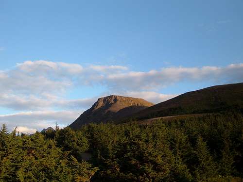
Approaching Flattop Mountain from Anchorage
Flattop Mountain is one of the most popular hikes for Anchorage residents and even for Anchorage visitors. In fact, it is one of the most popular hikes in all of Alaska.
There are several reasons for this.
1) The mountain is located within the limits of the Municipality of Anchorage, so it is easy to get to from anywhere in town.
2) Because the trailhead starts at around 2,300', a fair chunk of the climb gets knocked out by your vehicle.
3) It is a short hike, requiring forty minutes to an hour to reach the summit.
4) Because of the high latitude of Anchorage, the summit of the mountain is located above tree line.
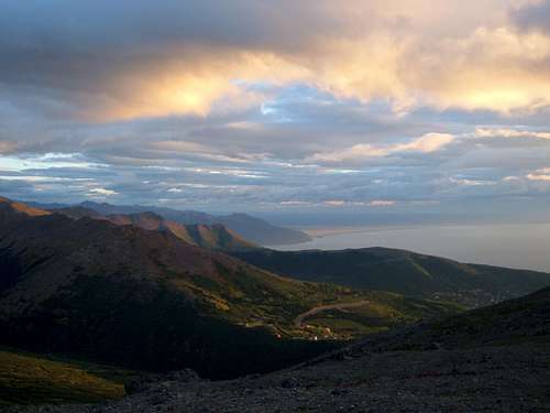
5) This is quite a beautiful mountain. While is doesn't necessarily stand out in the brilliant Anchorage skyline, once you get there, you enter another world. Sunsets over the Cook Inlet, and views to the Chugach Mountains are your reward for not too much effort. Scrambling up to the summit is very fun and for more dogged mountain hikers, you can drop down and continue along the class III ridge to the southeast to the next two peaks at elevations of 3658' (Peak Two) and 4111' (Peak Three).
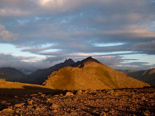
Peak Two and Peak Three from just east of the summit of Flattop
The only deterrent to hiking Flattop is the crowds. On a good, clear summer day, you may have to share the summit with dozens of others. I know people in Anchorage who routinely use the trail as a workout after work. My hike up this gorgeous little mountain was completed on a particularly beautiful evening in late-August at sunset.
Getting There
Getting to Flattop is easy. You take either Minnesota Drive or Seward Highway heading South and exit at O'malley Road.Take O'Malley Road for several miles to the east until you reach Hillside Drive on your right. There is a sign at the turn to Hillside Drive that says "Chugach State Park".
Take Hillside Drive for about a mile until you get to Upper Huffman Road on your left, heading towards the mountains. Take Upper Huffman to near its terminus where you take Toilsome Hill Drive. Toilsome Hill winds around the hillside (and turns seamlessly into Glen Alps). After a few miles you will see signs for the parking area and the Glen Alps trailhead on the left side of the road. The start of the trail itself is well marked.
Overall the trail is pretty straightforward. There are usually crowds, but if not, make sure to head in the most obvious direction. There are lots of little side trails, but you need to stay on the main trail. Early on you descend a long ridge to the start of the uphill climb. After about 1 mile you get to a sitting area with a bench. From here, a use trail goes some of the way up, but the last 200 feet or so is all class II scrambling. The rock quality is good, without much rock fall and excellent footholds and handholds at the tricky spots. Yellow targets on the rocks guide you in the right direction all the way to the top. At the summit you will see a couple wind shelters. The true summit is obvious when you get there.
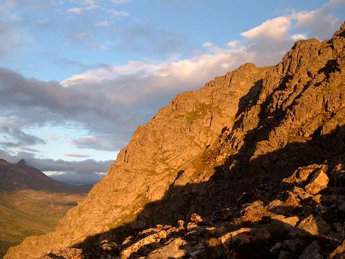
View from the trail of the north edge of Flattop
The summit is only 1.5 miles one-way from the parking area, with an elevation gain of 1252 feet. You gain roughly 1,000 feet in the last mile.
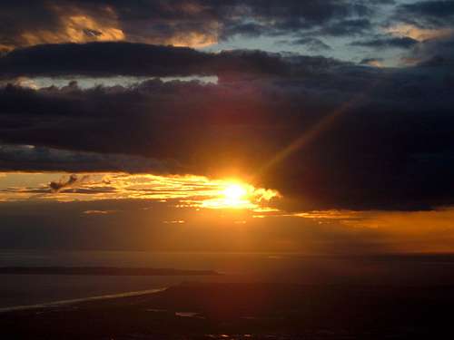
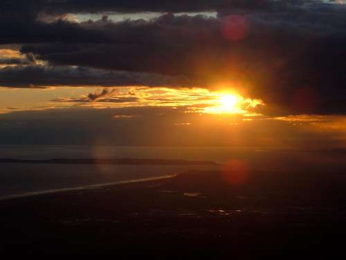
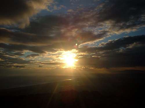
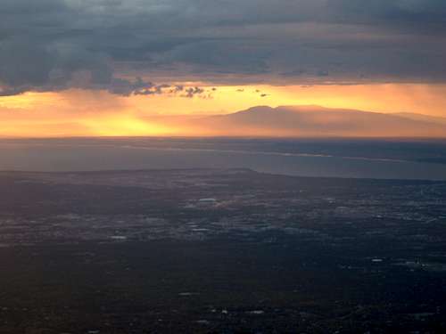
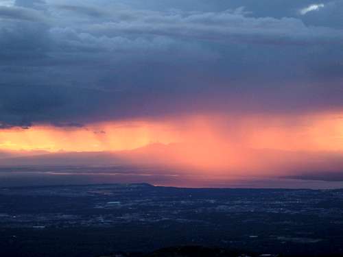
Sunset
Below are some gorgeous sunset views taken from Flattop on August 26th, 2007 between the hours of 8:45 and 9:15pm.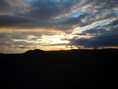
Red Tape
There is a parking fee for day use ($5) if you choose to park in the parking lot. The lot has about 40 or so spaces, and these can fill up fast during the summer. I parked on the road just before reaching the fee area where several other cars were parked. At that time (2007) you could be ticketed for this, but it wasn't necessarily enforced. More recently, however, ticketing has become far more vigorous for people overflowing onto the road outside the parking lot. The tickets are huge, because it is designated as a "fire lane".More recently another lot has been opened, by taking a ramp to the right of the ranger's cottage at the back of the main/old parking lot. Between the two lots, there are perhaps 200 spaces now; much better than it used to be.
Another option is a shuttle service to the trailhead. Details are found in the External Links section.
External Links
WikipediaREI Anchorage page
Local Hikes Trail Description
Flattop Mountain shuttle
Steve Gruhn - Jul 13, 2007 12:05 pm - Voted 9/10
CorrectionsYour photo labeled as looking northwest from the summit of Flattop Mountain is actually viewing to the west. Note Mount Susitna in the background. Also, you state that the parking lot is outside the city limits. It is, in fact, within the limits of the Municipality of Anchorage, as are the entirety of the Rabbit Creek and Campbell Creek drainages and Flattop Mountain (and the ridges to the southeast leading to Flaketop Peak) itself. You might also mention that this is probably the most popular hike in all of Alaska. And you might want to include it with the Chugach Mountains parent group. To turn off Upper Huffman Road, take a right on Toilsome Hill Drive. This will eventually turn into Glen Alps Road, but those traveling to the Glen Alps trailhead should be on the lookout for the sign for Toilsome Hill Drive.
hgrapid - Aug 23, 2007 2:32 pm - Hasn't voted
Re: CorrectionsI am planning to hike this mountain next week and I will adopt the page from the current maintainer. I will then address your corrections.
Steve Gruhn - Aug 28, 2007 4:00 pm - Voted 9/10
Some More Additions/CorrectionsPeak 3658 is known as Peak Two. Peak 4111 is known as Peak Three. You state that parking on the road near the Glen Alps Parking Lot is permitted. Signs indicate, however, that parking on the roadway is prohibited; park rangers will ticket vehicles parked there.
hgrapid - Aug 31, 2007 2:08 pm - Hasn't voted
Re: Some More Additions/CorrectionsSteve, What do you think of the page now that it is completed. I have taken your suggestions into account.
Steve Gruhn - Sep 11, 2007 4:29 pm - Voted 9/10
Re: Some More Additions/CorrectionsLooks pretty accurate.
hgrapid - Oct 7, 2010 12:09 am - Hasn't voted
Bizzare!That is odd. I must of changed it by accident, because it definitely used to be a - longitude. Very odd. I am always the one notifying people to fix that exact issue! It is fixed now.
hgrapid - Nov 22, 2010 2:41 pm - Hasn't voted
Re: TicketsThanks. I modified the section. What is the current day use fee in the main parking lot?
hgrapid - Mar 17, 2013 11:57 am - Hasn't voted
Re: External Link RequestDone
hgrapid - Sep 17, 2014 7:47 pm - Hasn't voted
Re: Parking & trail startThanks. Made some edits to reflect your comments.
Alaska101 - Oct 19, 2014 10:53 pm - Hasn't voted
CrowdedTons of people climb this every day! there must have been 20 on the summit last time I climbed it.