
|
|
Mountain/Rock |
|---|---|
|
|
36.02000°N / 118.253°W |
|
|
Tulare |
|
|
Hiking |
|
|
Summer, Fall |
|
|
9382 ft / 2860 m |
|
|
Overview
Bald Mountain is in the Sequoia National Forest on the northern boundary of the Domeland Wilderness and it is the site of a manned fire lookout. It is part of the Kern Plateau which rises between the North and South Forks of the Wild and Scenic Kern River. Bald Mountain provides superb views towards the north including: Olancha Peak, Mt. Whitney, and Mt. Langley. Looking east you can see all the way to Telescope Peak in Death Valley! Looking southward you see across the Domeland Wilderness and to Owens Peak. I am going to go out on a limb and say it's the finest view in the entire southern Sierra Nevada!Click here to find links to 4 webcams pointed in different directions from Bald Mountain.
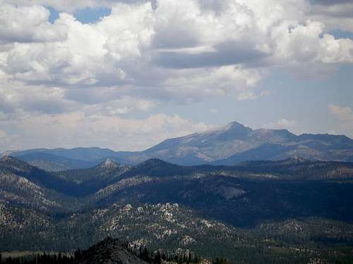 Olancha Peak as seen from Bald Mountain
Bald Mountain is also one of the Forest's Botanical Areas meaning a large concentration of rare plants is found here. It has been recognized for years by the scientific community as a most unusual botanical and geological island in the southern Sierra. This mountain offers a unique opportunity to interpret the unique plant assemblages that occur here.

Getting There
Access to Bald Mountain is via the Blackrock or Sherman Pass Road which is open late May/early June through late October/early November, depending on weather. About halfway between Blackrock and Sherman Pass take Forest Service Road 22S77 (dirt, high clearance recommended) southeast for 2 miles to a small turn-around parking area. From here it is about 1/3 mile uphill along a signed trail to the top of Bald Mountain.Sequoia National Forest Map based on Bonita Meadows Quad showing Bald Mountain
Other Sequoia National Forest Quad Maps
Buy a Sequoia National Forest Map
Red Tape
No permits or fees to hike to Bald Mountain. Please practice Leave No Trace ethics when you visit this area. Be sure and carry water with you as no water is available along the way or at the lookout.Upon reaching the lookout, a sign may be posted that will inform you if the lookout is open for public visitation. A Forest Service employee resides at the Bald Mountain Lookout tower. It is utilized as an office as well as the home for the summer months while the lookout is on duty. This person is responsible for detecting fires and relaying radio messages to a dispatcher, who in turn sends firefighters and support equipment to extinguish the reported fire. The employee is usually on duty from 8 a.m. to 5 p.m. but may have the lookout closed due to fires or repair work. If the gate is open, you are welcome to visit the lookout, talk with the Forest Service employee, and enjoy the view, which is spectacular.
No more than 4 people are allowed on the lookout at a time, as there is very little space. Please sign the daily log so we know you have been there. The lookout has just a couple of simple rules for safety; please do not sit on the catwalk railing or lean against any part of the building, particularly the windows or smudge them. The lookout needs a clean, unobstructed view at all times. The windows are very fragile and break easily.

Camping
The closest developed campground to Bald Mountain is Troy Meadow. For more information on Troy Meadow and other campgrounds on the Sequoia National Forest, please click on the link below. To make reservations visit www.ReserveUSA.comSequoia National Forest Campgrounds
You can also camp outside developed campgrounds in the Sequoia National Forest. Do not drive off road, pack out what you pack in, bring your own water, and make sure you have a campfire permit if you wish to have a campfire. Campfire Permits can be obtained free-of-charge at any Forest Service, California Department of Forestry (CDF), or Bureau of Land Management (BLM) office.
External Links
 Blue Penstemon and a Bee
Sequoia National Forest
Tulare Mountains Weather Forecast
Buck Rock Foundation
Sequoia National Forest Lookouts
For More Info
 Bald Mountain Fire Lookout
Sequoia National Forest
Kern River Ranger District
Kernville Office
105 Whitney Road
P.O. Box 9
Kernville, CA 93238
(760) 376-3781
Etc.
The Bald Mountain Botanical Area is 446 acres in size. Interesting plants found on Bald Mountain include:Bald Mountain potentilla Horkelia tularensis
Piute locoweed Astragalus subvestitus
Kern Plateau locoweed Astragalus lentiginosus kernensis
bitterroot Lewisia rediviva
common phoenicaulis Phoenicaulis cheiranthoides
cordate jewelflower Streptanthus cordatus
rockcress Arabis puberula
golden cryptantha Oreocarya confertiflora
buckwheat Eriogonum spp. (5 kinds)
curl leaf mountain mahogany Cercocarpus ledifolius
prickly phlox Leptodactylon pungens pulchriflorum
Other botanical areas on the Sequoia National Forest include Slate Mountain and Baker Point.
Why is it called Bald Mountain?
As you face the east ridge, the vegetation is dominated by shrubs. Some of these shrubs are actually low growing trees such as the Juniper or Limber Pine. The combination of steep slope, extreme temperatures, and high winds, plus the lack of protective snowpack on the 8,000’+ mountaintop, creates a harsh environment in which trees cannot reach their normal height. Many of the plants on the summit take a low to the ground “cushion” form, which is an adaptation to the sub-alpine conditions. All of this creates the impression of a “Bald Mountain.”
Island in the Sky
The rocks and soil are different here on Bald Mountain than the surrounding area. Ages ago, intense heat and pressure hardened mud, sea shells, and sand on the bottom of a vast ocean, forming layers of dark slate, white dolomite and sandstone. Now, 200 million years later, erosion and uplifts have left only a few of these metasedimentary formations. The soil made from these ancient rocks is richer in minerals and holds more water efficiently than the surrounding granitic soils. This results in the diverse and abundant plant life found on Bald Mountain.
Lookout Tower
In 1950 a tent platform was built on Bald Mountain and in the following year tower materials were packed in pieces by mule train from Kennedy Meadows, which was the end of the road in those days. In 1955 the tower's construction was completed and in 1967 the Lookout became accessible when access roads were built. Bald Mountain Lookout Tower scans over 1,000 square miles with a view of the Domeland, Golden Trout, and South Sierra Wildernesses, as well as Olancha Peak and Mt. Whitney, headwaters of the Kern Wild and Scenic River.
Manter Fire
From the summit of Bald Mountain one can still see the effects of the Manter Fire of 2000. It burned more than 73,000 acres and was at that time the largest fire in Sequoia National Forest history. Two years later the McNally Fire broke that record by a long shot.
mtbaxter - Sep 14, 2013 2:55 pm - Hasn't voted
Domeland Wilderness Area high pointIf you summit Bald Mtn, I highly suggest you go about 50 yds to the east along the east ridge. Here you will find the high point of Domeland Wilderness Area. It takes less than a minute from the road at the summit. Details can be found at peakbagger.com at http://www.peakbagger.com/peak.aspx?pid=43532 It is the 27th highest of California's 148 wilderness areas, and will put you on the FRL for Calif wilderness areas at Peakbagger.com