

|
|
Area/Range |
|---|---|
|
|
35.83563°N / 118.27744°W |
|
|
Hiking, Trad Climbing, Sport Climbing, Bouldering, Scrambling |
|
|
Spring, Summer, Fall |
|
|
Overview
The Domeland Wilderness occupies a large area (about 93,000 acres) along the South Fork Kern River Canyon at the southern end of the Kern Plateau in the southern Sierra Nevada Mountains. Most of the Wilderness is managed by the US Forest Service (Sequoia National Forest) but there is a small portion managed by the Bureau of Land Management (BLM). With elevations ranging from 3,000 - 9,730 feet, Domeland (on some maps and guide books it's known as Dome Land or Domelands) is a vast playground for hikers and especially for rock climbers. Beautiful granite domes stretch across the landscape as far as the eye can see. Most people visit Domeland in the spring or fall as much of the wilderness in summertime is hot!
Today, the most popular features for climbers are Church Dome, which is actually a complex of formations, and the spectacular Bart Dome. There are, of course, dozens of other domes and crags which have been graced by the presence of such notable climbers as Bob Kamps, Herb Laeger, Ron Carson, Mike Lechlinsky, Vaino Kodas, Erik Ericksson....
The Pacific Crest Trail (PCT) runs through the Domeland Wilderness and the surrounding area is also enjoyed by skiers and snowmobilers in the winter, and mountain bikers during the summer. The run down the Cannell Creek Trail, with an elevation drop of over 5,000 ft. into the Kern Canyon, is a world class bike ride.
Vegetation is primarily pinyon pine woodlands on the east and Jeffrey pine on the west with red fir, lodgepole, and foxtail pines at the higher elevations. There are many beautiful meadows with Manter Meadow perhaps being the most-visited and well-known.
Information on recent wildfires courtesy of mlarkin2002: "The area was heavily burned during 2000's Manter fire, and to a lesser extent, 2002's McNally fire. According to the ranger at Bald Mt. LO, Manter burned the southern area of the Domelands, and McNally came from the north. It's a great area, and is recovering well. Watch your campfires!" To which I'll add that there are a lot of burned trees in some areas so keep a watch for snags that may fall. I wouldn't set up camp in the burned areas due to the risk of falling trees. Also, when I visited in June 2005 the wildflowers in the burned areas were spectacular!
Domeland Wilderness was created in 1979 and 32,000 acres were added in 1984 under the California Wilderness Act.
Click here to view a webcam mountain on the Bald Mountain Lookout that looks south over the Domeland Wilderness.
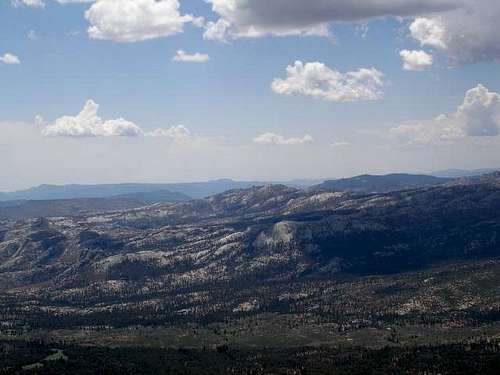
Looking across Domeland Wilderness from Bald Mountain
Getting There
Domeland Wilderness is located northeast of Lake Isabella about 70 miles northeast of Bakersfield. Trailheads on the east side are near Rockhouse Meadow and at the Long Valley Campground (BLM). Access is via Nine Mile Canyon Road from US Highway 395 or Chimney Peak Road via State Highway 178. West side trailheads are at Big Meadow and Taylor Meadow. Two trails from Big Meadow can be reached from Kernville via Mountain Road 99, Sherman Pass, and Cherry Hill Roads. Leading to Manter Meadow, the upper Big Meadow Trail is a rugged hike while the lower Big Meadow Trail follows more gentle terrain. The trail from Taylor Meadow (southeast of Big Meadow) also leads to Manter Meadow as well as Taylor and Church Domes. Northside access is available from the Blackrock/Sherman Pass Road via the Dark Canyon and Woodpecker Trails.
Blackrock/Sherman Pass and Cherry Hill Roads are accessible from late May to late October or early November, depending on weather.
One can also approach the Neanderthal Wall - the large rock formation visible high over the northern shore of Lake Isabella - from the end of Cherry Hill Road.
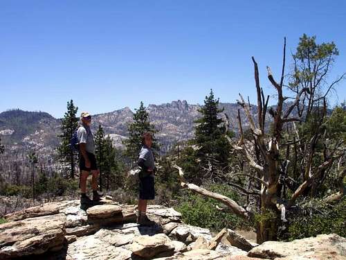
At the edge of Rockhouse Basin
Red Tape
Wilderness Permits
Wilderness Permits are not required for the Domeland Wilderness.
Campfire Permits
A California firewood permit is needed in order to have a campfire or charcoal barbeque outside of developed campground and picnic areas. You can obtain one at any Forest Service, CA Dept of Forestry, or BLM office.
Leave No Trace
Practice LEAVE NO TRACE! Minimize impact by camping at least 100 feet from streams, lakes, and trails. Pack out all you pack in. Body waste is to be buried 6 inches deep and 100 feet from rivers and streams. Keep fires small and leave them DEAD OUT by pouring water on it, then stirring. Do everything you can to protect water sources from contamination. Stay on trails and don’t shortcut switchbacks. Click here to find out more info on LNT.
Wilderness Regulations
All mechanized vehicles and equipment including mountain bikes are prohibited within the Wilderness. A maximum group size of 15 people / 25 head of stock per party has been adopted.
Pets
Pets are allowed on trails in the Domeland Wilderness but they must be under control at all times. On a leash is best. Pets must be on a leash at trailhead areas. Please be courteous and clean up after your pet as well.
Fishing and Hunting
Fishing and hunting is allowed in season. Check current California Fish and Game regulations.
External Links

Pine at the edge of Manter Meadow
Sequoia National Forest Website
Hike to Manter Meadow and the edge of Rockhouse Basin, June 2005
Kern County Mountains Weather Forecast
Tulare County Mountains Weather Forecast
Camping
Wilderness Camping
Backcountry camping around Manter Meadow is popular. Other suitable camp sites are also located at Little Manter Meadow, Woodpecker Meadow, Rockhouse Meadow, and in the Bartolas Country at the south end of the Wilderness. Practice LNT and camp adjacent to the meadows, not in them.
BLM Campgrounds
Chimney Creek Campground lies in a wooded canyon at abour 5,700' elevation. Located off Canebrake Road about halfway between Hwy 178 and Minemile Canyon Road, and a quarter mile from the PCT, this is a good staging area for the many peakbagging possibilities in the area. There are 36 sites with picnic tables, pit toilets, and fire pits with grills. No fees or reservations. Gathering down wood for fires is allowed, though you are encouraged to bring your own. There are water hydrants here and there, but if they are functioning, they should not be used. Naturally occurring Uranium contaminates the local ground water.
Long Valley Campground provides access to the Domelands Wilderness and the South Fork of the Kern River. It is located at an elevation of 5,200' just east of the Domelands Wilderness boundary. There are 13 sites. There is no drinkable water. From Hwy 178 take Canebrake Road north about 15 miles to a "Y" intersection (well marked, and the only one around). This is the Long Valley Loop Road. Turn left at the interesection and follow the road for about 10 miles to the campground. From the north, you can take Canebrake road from Ninemile Canyon Road to the above-mentioned intersection, or continue on to Kennedy Meadows and pick up the other end of the Long Valley Loop Road and come in from the north. No fees or reservations.
Forest Service Campgrounds
Kennedy Meadows Campground is located just north of the Ninemile Road. It is a popular jumping off place for PCT'ers. It is near the South Fork Kern River and at an elevation of 5,800'. Troy Meadow and Fish Creek Campgrounds are located along the Blackrock/Sherman Pass Road. They are at 7,800' in elevation and are popular campgrounds for OHV enthusiasts. Horse Meadow Campground is located on the Cherry Hill Road which connects with the Sherman Pass Road just west of the pass. It is at 7,600' in elevation and within a few miles of the Big Meadows area and several Domeland Trailheads. A fee is required at all four of these campgrounds.
More info on Sequoia National Forest Campgrounds
Suggested Books & Maps
Exploring the Southern Sierra: East Side by J. C. Jenkins
USFS Domeland Wilderness Map Order Form
Sequoia National Forest Maps based upon 7.5" USGS Quads