
|
|
Mountain/Rock |
|---|---|
|
|
35.93750°N / 118.2057°W |
|
|
Hiking, Trad Climbing, Scrambling |
|
|
Spring, Summer, Fall |
|
|
7600 ft / 2316 m |
|
|
Overview
Stegosaurus Fin is an impressive summit in the heart of the Domelands Wilderness in the Southern Sierra. The summit block is a massive, 50ft-high chunk of granite that appears overhanging or vertical on all sides. It's resemblance to the dinosaur's armor plate is marginal, but the name is one of the most colorful in the range. A fortuitous pile of rock on the east side and an improbable ledge combine to provide a class 4 route to the summit, making for one of the best summit blocks in all the Sierra. The peak is remote from all trailheads, and combined with its absence on any notable peak list, it sees few visitors. There was no summit register when visited in December, 2006.Located just west of Rockhouse Basin, Stegosaurus Fin is found in the rockiest and most impressive part of the Domelands. A fine view of this region can be had from Bald Mtn to the north and from along select portions of the paved road east of Sherman Pass. There are dozens of rocky peaks, domes, and outcroppings in the general area, with bountiful climbing opportunities.
The name of the peak is not official, and its origin is uncertain. From the SE the peak appears to look more like the whole dinosaur, though again I think the resemblance marginal. The name appears among other places, in J.C. Jenkins, Exploring the Southern Sierra, East Side.
Getting There
 Stegosaurus Fin from the south
 Stegosaurus from the west
Find your way to the north side of the peak, about 100 yards below the summit. If coming from the west, you can climb directly up the class 2 West Slope to a notch leading to the north side. If approaching from the east, climb slopes on the southeast side (well to the right of the summit), up and over a saddle and then a boulder scramble to the north side.
Climbing the Fin
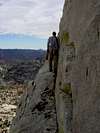 The Improbable Ledge
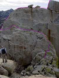 Class 4 Route
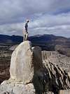 At the very top
Red Tape
Permits are currently not needed for overnight stays in the Domeland Wilderness, though a fire permit is required for stoves or open fires outside developed campgrounds. The access roads close in winter sometime between October and December, opening after snowmelt in the early spring. Contact the Ranger Station in Kernville for road conditons and closures (they seem more knowledeable than their counterparts at the Lake Isabella Office):Kern River Ranger District - Kernville Office
105 Whitney Road
P.O. Box 9
Kernville, CA 93238
760-376-3781
FAX 760-376-3795
TDD Available
Monday through Saturday, 8:00am - 4:30pm