I. FOREWORD
In case you’ve ever wondered, the effort to get to the magnificent Kaweah ridge in the center of the Sierra Nevada pales in comparison to the rewards. Not to pooh-pooh the commitment required--it is substantial because of the area’s remoteness--another way of saying there is no easy way to get there.
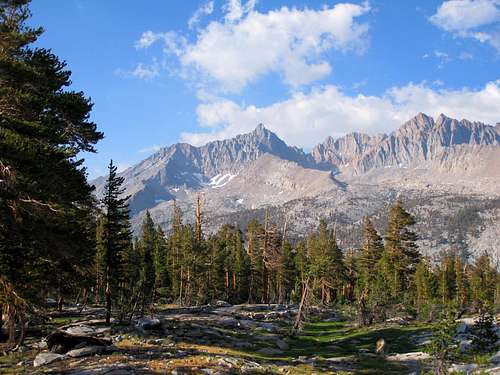
![Kaweah Peaks]() Kaweah Peaks seen from Little 5 Lakes area
Kaweah Peaks seen from Little 5 Lakes area
This trip report will be a little lengthy, but the subsections are meant to be self-contained so feel free to skip around without losing too much in the translation. One reason for length is that I will make an effort to provide detail on our route that might be helpful to others attempting the Kaweahs.
II. THE PLAN: THE "EASY" APPROACH FROM THE WEST
I had the good fortune to have a friend and hiking/climbing partner, Tom Becht
(SP bechtt), who initiated the plans to tackle the Kaweahs. A third candidate was unable to make it, so it was Tom and me in the end.
Of the two approaches, we chose the “easier” one from Mineral King. This would involve a 26-mile roundtrip with 11,000 feet of gain to climb the coveted Black Kaweah. But
18.5 of those miles would be with full backpack and 8,200 feet of gain! I’m not as successful at going ultra light as Tom is, either with a day pack or an overnight pack. Taking too much food was one mistake for me, but that’s in hindsight. We opted to take along ice axe and crampons in case needed. We didn’t want to fail to summit any of the peaks due to lack of equipment. We vacillated on the need for tents until the very last minute. We decided to take our respective one-man tents in case of inclement weather (which we got but not at camp).
Tom picked me up at my house in South Pasadena Wednesday after work and we drove to Mineral King. Woe be to anyone who gets car-sick on winding roads because the 25 miles along Mineral King Road are excruciating enough without a queasy stomach.
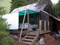
After arriving at the Sawtooth Trail trailhead we started to throw our sleeping bags beside the car for the night. Just then, we were accosted by a friendly soul who asked about our plans. Mentioning the Kaweahs brought no sign of recognition to his eyes. Turns out he was visiting his uncle and was not an outdoors type except perhaps for drinking beer on the veranda. Turns out his uncle had a “cabin” (a hovel actually) right next to the trailhead. “Uncle Sawtooth” invited us to sleep on his open back porch. We took him up on his offer. In hindsight, we regretted the decision because nephew had his bedroom out there as well and snored continuously at full volume all night.
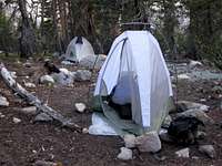
![Trailhead Bunking]() Our accomodations at the Sawtooth trailhead
Our accomodations at the Sawtooth trailheadIII. MINERAL KING TO THE BIG ARROYO: A SKEPTICAL RANGER
The next morning, we arranged our packs and drove the short distance back to the ranger station to pick up our permit. The ranger asked Tom about our food storage arrangements. Tom told him that we did not have bear cannisters (they are not required) and planned to store our food at the food lockers at the Big Arroyo campsite. This drew a big raised eyebrow from the ranger:: “You plan to backpack all the way to the Big Arroyo from here in one day?” Tom gave a firm “yes” but hedged the bet by letting the ranger know that we were aware that there were bear boxes at Little Five Lakes, 3 miles short of Big Arroyo. The final preparatory step for leaving was to “marmot-proof” Tom’s Honda Element by leaving the hood up (the theory being that marmots only like to nibble rubber car parts in confined spaces).
![Beginning of Western approach to the Kaweah Peaks]() Sawtooth Trail Trailhead
Sawtooth Trail Trailhead![Surefire Marmot Protection]() One method of marmot-proofing
One method of marmot-proofing
After a couple of miles up the Sawtooth Trail, we came upon the “old” trail toward Glacier Pass partly along Monarch Creek (marked by a sign “Trail Not Maintained”). The trail runs through a wide glaciated alpine canyon. We started the long hump with full packs to Glacier Pass. The trailhead is at 7,800’ and Glacier Pass is at 11,200’ so our first leg had 3,400 feet of gain.
![Along Sawtooth Pass Trail]() Looking back on Sawtooth Trail en route to Glacier Pass
Looking back on Sawtooth Trail en route to Glacier Pass
Once at Glacier Pass, we could see the Great Western Divide several miles to the northeast. We could also see much of our route down towards the gorgeous Spring Lake. The big switchbacks leading to Black Rock Pass, an alternate route, were also visible in the distance.
![Sawtooth Mountain Sierra Nevada]() Sawtooth Mountain from Sawtooth Trail
Sawtooth Mountain from Sawtooth Trail![Rock Rubble High Point above Glacier Pass]() Rock Rubble above Glacier Pass
Rock Rubble above Glacier Pass![Looking toward Glacier Pass]() Ascending Glacier Pass
Ascending Glacier Pass
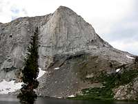
On the descent from Glacier Pass we kept to the old trail, which seems to follow the most moderate slope down (other points of descent from Glacier Pass don’t look too hospitable). Down we went through meadows and rock slabs a thousand feet to Spring Lake. Here tumbled waters from Columbine and Cyclamen lakes. Another striking feature at Spring Lake is the massive cliff of the north face of Spring Lake Wall (11,480+’).
![Spring Lake below Glacier Pass]() Spring Lake below Glacier Pass
Spring Lake below Glacier Pass![Kaweah Peaks from near Glacier Pass]() First good view of the Kaweah ridge from near Glacier Pass
First good view of the Kaweah ridge from near Glacier Pass![Spring Lake Wall]() The spectacular Spring Lake Wall
The spectacular Spring Lake Wall
We skirted the north end of Spring Lake and then swung to the right of the west-facing slope to Hands-and-Knees Pass. As mentioned, an alternative route from Spring Lake is over Black Rock Pass. But Hands-and-Knees Pass served us as well and was 600 feet less gain to boot. A traverse northeast led to the ridge dividing Big Five Lakes from Little Five Lakes basins. The notch that drops you into Little Five Lakes Basin is obvious from afar.
![Hands-and-Knees Pass]() Hands-and-Knees Pass
Hands-and-Knees Pass![Black Kaweah (13,765 ) (C) after a Sierra Shower]() Black Kaweah from Little 5 Lakes
Black Kaweah from Little 5 Lakes![Black Kaweah (13,765 ) from Little 5 Lakes area]() Looking across one of Little 5 Lakes to Black Kaweah (L)
Looking across one of Little 5 Lakes to Black Kaweah (L)![Mt. Eisen (L) near Blackrock Pass]() Mt. Eisen (L) near Black Rock Pass
Mt. Eisen (L) near Black Rock Pass
As we descended into Little Five Lakes Basin, Black Kaweah became a dark, looming presence. The mountain seemed to say: “Well stud, you’ve come this far, now come get me.”
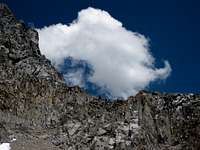
Like good planners, we had checked the weather forecast for today before setting out. Reports were for sunny and sunny. But showing that she is no respecter of forecasts, Mother Nature unleashed a torrential hour-long storm complete with large-sized hail. Our rain covers began to leak and, at one point, we huddled under a tree to escape the deluge. July is a month for Sierra skeeters to be out in force and this area was no exception. They pounced on us at the passes, on the trail, and especially along the creeks.
Once the rain stopped, the skeeters descended in force preventing snack and rest stops although you could get minute bits of protein into your system by breathing through your mouth and inhaling quantities of mosquitoes with each breathe.
From Little Five Lakes, a sign points “2.9 miles” to the Big Arroyo, all on trail. The drop is about 1,000’ and the lower you go, the more imposing Black Kaweah seems to become. Red Kaweah and Squaretop Mountain, imposing in their own right, also spring into view, as well as the pinnacles on the Kaweah ridge.
![Squaretop Mountain between Kaweah Peaks]() Squaretop Mountain on the Kaweah ridge
Squaretop Mountain on the Kaweah ridge
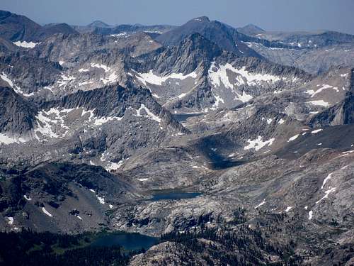
The Big Arroyo, at 9,500 feet, is a massive and beautiful gorge with lush forests and meadows. The High Sierra Trail runs along its eastern boundary. On its west side are the granite monoliths of the Great Western Divide and, to the east, the massive cluster of the Kaweah Peaks.
Tom arrived at the Big Arroyo well ahead of me. The river crossing was a bit of a challenge. I opted not to take off my boots and headed for a log that spanned the river. I got almost all the way across on the log but my last step hit a slippery spot causing me to land feet first in the river. I’d have to live with wet boots until well into the next day.
Amazingly, the remote Big Arroyo campsite was packed that first night. A couple of large groups were in town to do who knows what. It wasn’t to climb the Kaweahs because they were gone the next day. Anyway, Tom and I set up camp, had dinner, and agreed on a 5:30 a.m. wake-up for our Friday objective of Mount (aka Big) Kaweah. By 8:30, I lay comfortably in my tent entertained by Beethoven’s 4th Piano Concerto (the 2d movement is among the melodious glories of Western art) and then Sibelius’s Symphony No. 2. I was thankful I hadn’t bowed to the dictates of ultra light packing and left my ipod behind.
![Home in the Big Arroyo]() Home at the Big Arroyo
Home at the Big ArroyoIV. MT. ("BIG") KAWEAH: TRAIN WRECK SUMMIT
The Highest Kaweah via its SE Slope
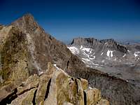
We awoke to good weather and were off by 6:30. From our tent, we took the High Sierra Trail southeast for about 1.25 miles. We then left the trail at a point just to the right of a creek whose headwaters lie between Red Kaweah and Mount Kaweah. Our direction up the ridge was northeast. Up through forested ridge alternating with small boulder fields we went. We refilled water bladders before leaving the tree line. Two sizable unnamed lakes below the sand-choked southeast slope of Big Kaweah served as hand-rails as we skirted to their right on the ascent. At the base of the slope, the saddle just west of Big Kaweah is in view as a target. I can’t say that the slog up the sand and scree was fun, but at last we found ourselves on the Kaweah ridge where we headed east.
![Kaweah Peaks]() View on ascent to Mt. Kaweah
View on ascent to Mt. Kaweah![Mt. Kaweah (13,804 ) Saddle]() Saddle west of Mt. Kaweah
Saddle west of Mt. Kaweah![View on climb of Mt. Kaweah]() View near summit of Mt. Kaweah
View near summit of Mt. Kaweah
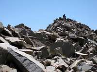
When the summit came into view, it looked like a giant pile of rock rubble, the visual equivalent of a train wreck. Tom had been quite a bit in front of me and he cut a solitary figure sitting on the highest pile of rocks waiting for me. But when we focused on the views from
this highest of the Kaweah peaks, elevation 13,804 feet, we forgot about the slog up and the jumbled appearance of the summit.
![Rubble of Mt. Kaweah Summit]() Summit of Mt. Kaweah
Summit of Mt. Kaweah![Forlorn on the mountain top]() Tom cuts a forlorn figure on Big Kaweah's summit rubble
Tom cuts a forlorn figure on Big Kaweah's summit rubble![Lifting a Chunk of Mt. Kaweah]() My summit pose
My summit pose
We got superb views of the eastern Sierra ridge from Mt. Russell to the flat profile of Mt. Langley. Mt. Williamson and Mt. Tyndall stood out as well. There was a register inside an aluminum California Alpine Club box. We signed it noting that
we were the first visitors in 2008 to the top of Big Kaweah.
![Mt. Langley (R) to Mt. LeConte from Mt. Kaweah]() Mt. Langley (R) and Mt. Whitney area (L) from Big Kaweah's summit
Mt. Langley (R) and Mt. Whitney area (L) from Big Kaweah's summit![SPers in Mt. Kaweah Summit Register]() SPers Burd and others in register
SPers Burd and others in register
After Big Kaweah, Tom wanted to check out Second (aka Gray) Kaweah (not an SPS peak). I wasn’t sure I wanted to expend the effort. We descended Big Kaweah and traversed west to the base of Second Kaweah. Tom took off on the nasty boulder route towards the summit. I enjoyed some snacks and the views, and in general became very relaxed. The decision to forgo Second Kaweah was easy. I sat there for an hour soaking in the atmosphere before heading back to camp.
The High Sierra Trail
I retraced our route taking as a major reference point the two unnamed lakes mentioned above. I took it real slow and enjoyed the descent: down the sandy slope, past the lakes, through the meadow and down the forested slope that intersected the High Sierra Trail. I was amazed how beautiful this trail really is. Lush foliage carpeted the slope below the trail down into the Big Arroyo. The trail ran through the creek at times and numerous little falls splashed across it into the Big Arroyo.
![A Waterfall crosses the High Sierra Trail]() Waterfall across the High Sierra Trail
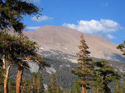
Waterfall across the High Sierra Trail![Mount (aka Big) Kaweah (13,804 )]() Big Kaweah (13,804') seen from High Sierra Trail above Big Arroyo
Big Kaweah (13,804') seen from High Sierra Trail above Big Arroyo
I arrived back at camp refreshed although, earlier in the day, I had been hurting on the ascent of the sandy slope to Big Kaweah’s saddle. We had done
about 8 miles with 4,300 feet of gain (not counting Tom’s additional gain to Second Kaweah). Tom came into camp not long after me, confirming that he summited Second Kaweah, but had abandoned the idea of taking a peek at the base of Red Kaweah.
Before dinner I took an invigorating bath in the cold river and managed to climb into dry clothes before the mosquitoes swarmed me. Since our route to Black Kaweah the next day would begin straight up the ridge above our tent, we agreed on a relatively late 6 a.m. wake-up.
V. BLACK KAWEAH: THIRD CLASS ROUTE (??) AND A WHO'S WHO SUMMIT REGISTER
To the Southwest Face
![Black (L) and Red (R) Kaweah]() Black (L) and Red (R) Kaweah early on our route
Black (L) and Red (R) Kaweah early on our route
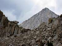
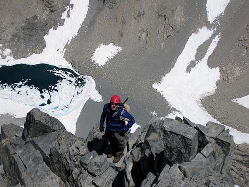
Saturday morning, we got off a little before 7. Our route would be the southwest face, reputed to have one or more Class 3 routes. We walked the very short distance to the sign on the High Sierra Trail pointing to Kaweah Gap and began our climb straight up the extremely steep ridge. We were basically taking aim at the big tarn below the peak. I’m one that likes a little warm-up on a hike or climb before setting foot on steep stuff. But there was no such foreplay on today’s route. Our warm-up was a 65 degree slope. Then we reached a beautiful high meadow, and, sooner than I expected, reached the big tarn southwest of the summit. The tarn was approximately half-way between camp and the summit.
![The Tarn below Black Kaweah]() Looking across the tarn below Black Kaweah
Looking across the tarn below Black Kaweah
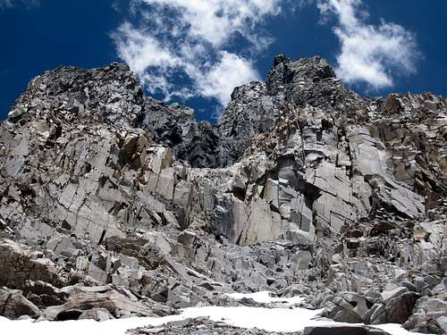
Now it was time to fish or cut bait as to our intended route up the SW face. What the hell? It all looked dark and forbidding, no matter which gully or off-shoot we eye-balled. We had both read the guide references and available TR’s and knew about the Righthand Chute that is supposed to start the route and the main chute to the left that is supposed to deposit you on the summit ridge. But, from the bottom, it didn’t really look neat and tidy like that at all.
![Looking up Descent Route on Black Kaweah]() Our route up Black Kawea on 7.19.08.
Our route up Black Kawea on 7.19.08.![Route up Black Kaweah]() Another view of our route
Another view of our route
From the tarn, we still had a ways to go over nasty scree and rock. Near the base of the main gully, we edged around a snow tongue and left our trekking poles at the top of the tongue. We then started up the broad chute looking for that elusive 3d Class route.
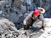
![bechtt on Black Kaweah]() Tom moving up on route
Tom moving up on route
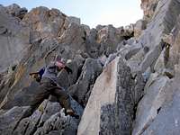
Pretty quickly, we encountered 4th Class rock and wondered aloud where the 3d Class ramp was. Oh, well; we were both confident in our abilities on 4th Class rock. But one thing that grabbed my attention as never before on other 4th Class routes was the exposure on Kaweah. It reminded me of the common description of 4th Class as equivalent to climbing a ladder a mile in the air: the holds are there but you’d better not fall. It was exactly so on Black Kaweah. As I tested holds—and several book-sized flakes came right off easy as pie-when I grabbed them—I noticed that there was nothing but soft air below my feet. If you fell, you’ve wouldn’t even hit solid rock for hundreds of feet.
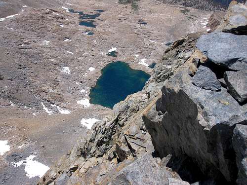
![Exposure on Black Kaweah (13,765 )]() Exposure summa cum laude (looking down at tarn)
Exposure summa cum laude (looking down at tarn)
The climbing difficulty was sustained. Tom and I expressed to one another that we hoped we would encounter a 3d Class route on the way down, deluding ourselves that maybe the 3d class section was more evident on the descent than on the ascent. That wasn’t the case.
![Little Leap of Faith]() Tom makes a committing move
Tom makes a committing move![Route on Black Kaweah]() Nearer the summit ridge it looked like this
Nearer the summit ridge it looked like this
In some ways, the route-finding itself was not difficult. Just get up the big chute and hang a right at the summit ridge. But care had to be taken on the chosen lines to avoid traipsing onto 5th Class rock. At one point on the ascent, I did exactly that as I split off from Tom’s line to ascend what I thought was a non-lethal line. Tom had a better vantage point than I did of where my line led and he made an emphatic comment to the effect that I should not continue my “variation” unless I didn’t mind sustained 5th Class free-soloing. I did mind. It felt very dicey downclimbing back to where Tom was but there was no choice. Gingerly, I got back on track.
Long Exciting Summit Ridge
At last, we reached the summit ridge. It was much, much longer than I expected. It also narrowed to a foot or so in some places and one six foot high block smack dab in the middle of the route required us to wrap both arms around the block in order to stay attached to the mountain and edge around the block.
This ridge was fun, exciting stuff, a real treat. The high point came into view and Tom and I summited together. At 13,765’, Black Kaweah is only slighter lower than sister Mt. Kaweah.
![Views just below Black Kaweah (13,765 )]() Panorama from near summit
Panorama from near summit
It goes without saying that the views were magnificent. The Whitney area, the Palisades, and much, much more. Then we both took our turns with the summit register. Tom told me that some busybody had threatened to climb Black Kaweah and withdraw the original register to Berkeley’s Bancroft Hall. But he hadn’t done it yet and we were ecstatic to find it still in the register box.
![A Treasured Register Box]() I hold the Treasure-Filled Register Box
I hold the Treasure-Filled Register Box
The register is a Who’s Who of famous Sierra Nevada hikers and climbers: Norman Clyde, Eichhorn and Dawson and Smatko and Heller. One featured page was the 1929 entry of Walter (“Pete”) Starr, Jr., in his own blood for lack of a writing implement, the date and signature still dark and prominent after over 8 decades. When entering our own names into this 84-year old document, we were by no means the first to express the sentiment that it was a privilege to sign the same register as the pioneers of Sierra Nevada hiking and mountaineering.
![Blood Signature on Black Kaweah]() Blood Signature 1929: Walter Starr, Jr.
Blood Signature 1929: Walter Starr, Jr.![Downclimb of Black Kaweah Knife Ridge]() Tom starts down the greatly exposed summit ridge
Tom starts down the greatly exposed summit ridge
After 45 minutes on the summit, we began our descent. We resolved to be especially careful knowing that the summit was only the half-way point of our outing and having experienced the loose rock and steep, sandy sections on the way up. We tried to exercise good downclimbing management by alternating going down when a particular section was too narrow to descend side by side. However, at one point, while I was waiting for Tom to descend one section, I shifted my weight while in an otherwise completely stationary position, and caused a softball-sized rock to unleash right towards Tom. I of course yelled out a warning. Fortunately, the rock missed Tom. Thereafter, I determined not even to take a deep breathe while waiting above for Tom to get clear of a section.
Besides rocks whirling through the narrow chutes, the diciest part of our downclimb came on a 20 foot section of low 5th Class rock. Tom reached it first and exclaimed, “I don’t like the looks of this at all.” Tom studied the section and carefully downclimbed. This is the only section of downclimbing where I had to face into the mountain.
![Looking up after Downclimb]() Looking back at downclimbed section
Looking back at downclimbed section
We breathed a sigh of relief when we made it down to the base of the main gully. We swung over to the snow bank to retrieve our trekking poles and then started the long descent back to camp.
We arrived back at camp about 8.5 hours after we had started. We had enough energy to decide to break camp and hoof our packs the 3 miles and 1,000 feet of gain to Little Five Lakes Basin to overnight there and thus have less distance the next day to get back to Mineral King.
VI. MARMOTS COOPERATE
Sunday morning, we were off by 6:30. As we ascended to the upper lake region of Little Five Lakes, we took in some last views (and photos) of the Kaweah ridge. It looks particularly awesome from that vantage point. Hands-and-Knees Pass seemed to come up relatively quickly. Then the giant drop to Spring Lake, followed by the upswing towards Glacier Pass. Near the top of Glacier Pass, I remember being almost mesmerized by two gushing tongues of glacier water plunging from above.
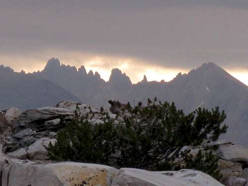
![Kaweah Peaks at Daybreak with Weather Forming]() One last look at Kaweah ridge (with weather brewing) en route to Hands and Knees Pass
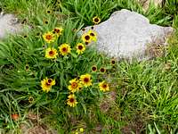
One last look at Kaweah ridge (with weather brewing) en route to Hands and Knees Pass![Sunflowers on trail to Sawtooth Trailhead]() Sunflowers along the Sawtooth Trail
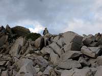
Sunflowers along the Sawtooth Trail![Lonely Figure on Hands-and-Knees Pass]() A solitary figure on Hands-and-Knees Pass
A solitary figure on Hands-and-Knees Pass
After topping out on Glacier Pass, we took a more direct route to catch the unmaintained trail than we had on the way up. This descent over scree and boulder fields was painful for me as my toes had now become very tender from banging against the front of my boots. Finally, we reached the old trail and sailed down to the trailhead. On top of a great trip, the marmots had left Tom’s car’s hoses alone. We couldn’t ask for anything more.


Comments
Post a Comment