
-
 43292 Hits
-
 88.61% Score
-
 27 Votes
|
|
Mountain/Rock |
|---|---|
|
|
45.23300°N / 14.96700°E |
|
|
4370 ft / 1332 m |
|
|
Geographical structure
Dinaric Alps > Velika Kapela GROUP > Bijele and Samarske stijene
Overview
Deep dark green coniferous trees and mixed woods contrasting white sharp limestone rocky towers and other strange carstic shapes – these are Bijele and Samarske stijene (White and Pack-saddle rocks), a subgroup in Velika Kapela a mountain group in Gorski kotar (Mountain region) in western Croatia, south of mountain Bjelolasica.
In south-east continuation to Samarske stijene (1,302 m) and Bijele stijene (1,332) mountains, lays the mountain Velika Javornica (1,375 m) (45°12'20N, 14°59'33E) which, because of some common features, I have also included in Bijele and Samarske stijene subgroup page.
Approximate borders of Bijele and Samarske stijene area include the non-paved road Jasenak-Mrkopalj (and Tuk Mrkopaljski) on east and north-east side of the mountains, Jasenak-Novi Vinodolski road on its south side and vast expanses of Velika Kapela woods on western and south-western side.
The mainstream of geographers and scientists had not visited, or even heard about those mountains until 1899. But even after that period, with exception of foresters and some hunters, Bijele and Samarske stijene were very much inaccessible to the public in absence of appropriate access roads, and the mountains´ sheer ruggedness. This fact is important to understand why they remained unscathed until our time.
When looking from above (from nearby Bjelolasica mountain f.e.) one can differ three distinctive mountain parts Samarske stijene, Bijele stijene and Velika Javornica. While Bijele and Samarske stijene are characterized by a white-limestone rocky mountain ridges broken into many smaller rocky clusters or isolated rocks that stand out of surrounding mixed woods, Velika Javornica looks covered up by wood all the way up to its summit.
And those limestone rocky formations are the most famous feature of Bijele and Samarske stijene. For nowhere in Croatian carst, except some parts of Velebit mountain, has limestone been so deformed (and formed) by water, snow and other physical forces, like here.
A detail from Ljuska (a nutshell, transl.) a cluster of limestone rocks at NW part of Bijele stijene (White rocks, transl.)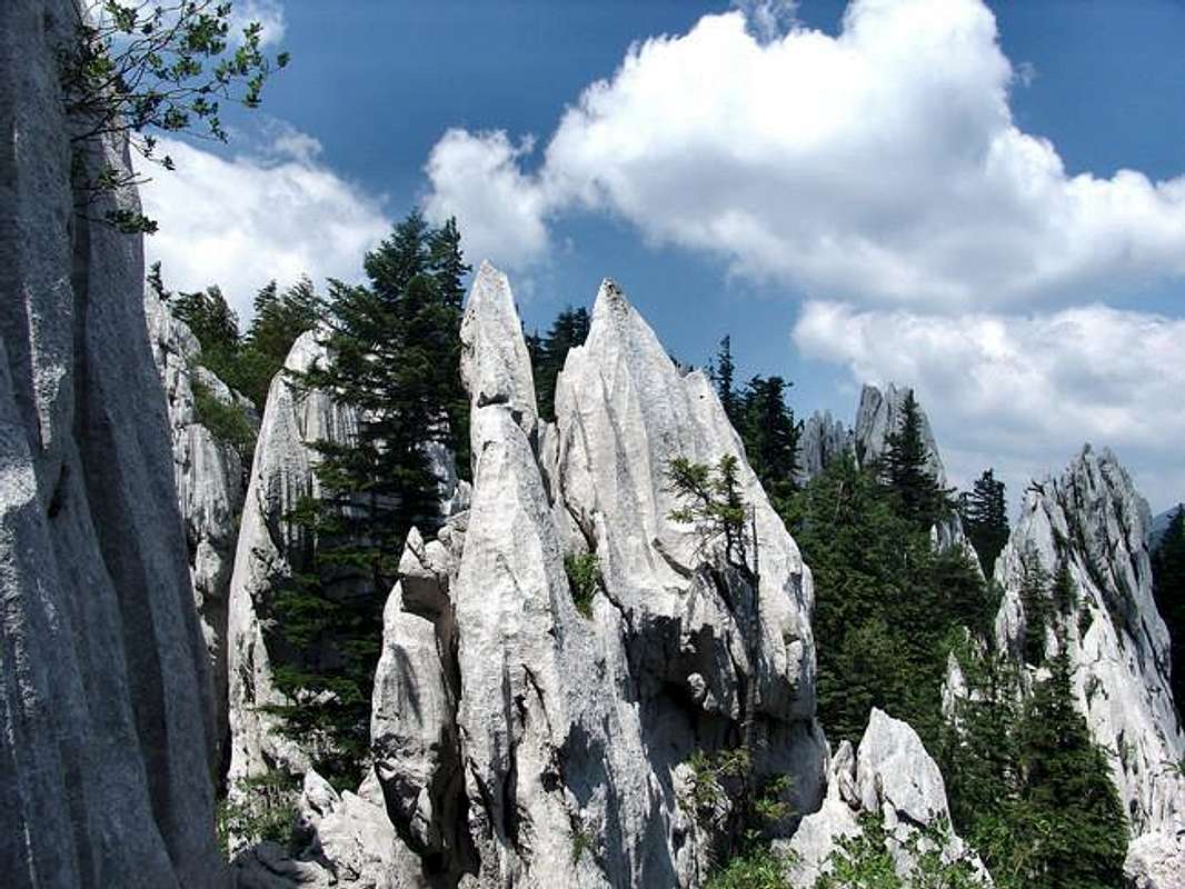
Even those parts that appear to have more „tranquilized“ terrain because the are covered with woods, in reality under their green roof they are also full of scattered rocks, stone formations and all other carstic shapes, figures and formations.
Because of its limestone structure there is no surface water in Bijele and Samarske stijene area, despite lots of rain and snow during the year. Snow drifts can remain up late into spring in snow-holes that exist here.
By the Law, Bijele and Samarske stijene have the status of Strictly protected natural reserve (cca 5 sq kilometers), which is the highest conservation status, even more rigorous than the national park is. This means no human intervention is allowed here more than existing, and moving away from marked routes is highly discouraged.
Symbol of the rocks is edelweiss which can be found on many rocky summits of Bijele and Samarske stijene.
Surrounding woods are the habitat of many wild species as bear, fox, wolf, wild cat, lynx and other animals. They are landlords here, and you are only a guest.
Despite very difficult configuration a rather good network of mountain paths have been established in the area, passing through its wildest parts – thus making the paths even more attractive. You can approach the most of those paths by two - above mentioned - non-paved forest roads that came close to the foot of the mountain from north-west and south east.
Bijele stijene (White Rocks) (1,332 m)
Major mountain ridge of Bijele stijene folows direction of Dinaric sprawl (NW-SE), but the ridge itself (3-4 kms) is broken into many rocky clusters connected or separated by passes, traverses, small canyons, small fields, holes.
The most visited part of Bijele stijene and the most usual access point is at its south-eastern side where a path from Jasenak via Rusov jarak reaches Bijele stijene mountan hut. The main summit of Bijele stijene (1,332 m) is only 10-15 minutes away from the hut. But this just the beginning (or the end, as you wish) of Bijele stijene because the summit is situated at southeastern edge of Bijele stijene, while most of its rocks and tops are situated northwest of the summit. Such a situation enables you to have an excellent view of the most of Bijele stijene and Samarske too from the summit.
The cluster of limestone rocks that makes the highest summit of Bijele stijene (the highest point at 1335 m is at left). The five rock formations on the right side are shaped in a form of a palm (of a hand), therefore they are called The fingers (Prsti, orig.)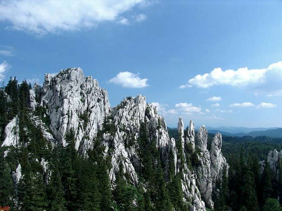
 |
 |
 |
 |
 |
Samarske stijene (Saddle Rocks) (1,302 m)
If you think it is impossible to visit a Pyramid, a Sugar loaf, Grand Canyon, A castle, Amphitheatre and see Sherpas in one day you are wrong. You can do it here on Samarske stijene. These are some of toponyms in Samarske stijene – all the names people gave to rocky formations they found here. Maybe one of the reasons for such unusual names is that this mountain has been explored in detail very lately, so modern people gave the names according to the period they lived in and according to contemporary associations - and modern man is more cosmopolitan than were previous generations - that used to have more traditional associations and more traditional names.
Samarske stijene have similar features as Bijele stijene, except they do not have a major and distinctive mountain ridge. Instead, around 20 rocky white limestone clusters of Samarske stijene are grouped in two parts: Northern group with the summit of Samarske stijene (Vrh Samarskih stijena 1,302 m) and southern Group (Juzni vrh – south peak, 1,299 m).
In the north-east corner of Samarske stijene (where the shortest connection to Jasenak-Mrkopalj road is) in a half-cave under Sherpas rock, a small mountain hut was built and named «Ratkovo skoloniste» (Ratko´s shelter). This hut is the best starting point and rest place if you plan to visit both groups in Samarske stijene.
 |
 |
 |
 |
Velika Javornica (1,375 m)
Although it looks very compact from distance Velika Javornica has more summit ridges radiating from the main peak. They meet in the middle of rocky ridge in a 8 m high rock that make Javornica´s highest peak. The summit itself is a bit elongated with two tops, each one with a different view.
There is only one trail that passes over Velika Javornica mountain and its summit. Coming from north, from direction of Bijele stijene it continues by the summit in south direction to Stalak and Kolovratske stijene (Kolovratske rocks) in direction of Adriatic sea and Velebit mountain.
Because of its separated position and its height, the panorama from Velika Javornica is very nice. Especially nice views are on Bijele and Samarske stijene, Bjelolasica and Klek mountains.
Although Velika Javornica is the highest mountain in this subgroup, I (like many others also do) have given a priority to Bijele and Samarske because of their attractivity and popularity.
 |
 |
Getting There
The major ascent points to Bijele and Samarske stijene are villages Jasenak, Tuk Mrkopaljski and Begovo Razdolje.
You can also reach Bijele and Samarske stijene from other mountain locations: from the direction of Bjelolasica mountain and other mountains in Gorski kotar region or from Kolovratske stijene in Kapela and further away from Velebit.
1. To get to Jasenak or Vrelo villages
By bus: Local buses to Vrelo or Jasenak drive from Ogulin bus station app. 2 times a day in the target direction. They do not drive weekends!!
For buses to/from Ogulin see schedule at: Ogulin Bus Station.
By car: From Zagreb direction take A-1 highway, end exit Ogulin. Pass through the town of Ogulin and at the western edge of Ogulin turn south in direction of Jasenak and „HOC Bjelolasica“.– you will notice signs for Bjelolasica still when driving highway and all the way through Ogulin.
To reach Jasenak from Split direction you can approach also by highway A-1, exit Ogulin then to HOC “Bjelolasica”. If coming from Split or Senj you can also turn to NW direction from village Jezerane (on A-1 highway, on Brinje-Ogulin section). From Jezerane you should go in direction of Dreznica village (30 km to Jasenak)
If you are coming from Novi Vinodolski (at Adriatic coast) you should drive up the coastal mountains above Novi Vinodolski in direction of villages Ledenice and Breze and after reaching them just follow signs for Jasenak or Ogulin.
By train: On Zagreb-Rijeka and Zagreb-Split railways take off at the Ogulin station.
Schedules at Croatian Railways. (For Zagreb departure choose “Zagreb Gl.kol.”– Zagreb Main Station) or Ogulin Train Station
Detailed info how to get to Vrelo (HOC Bjelolasica) at: Sports Center Bjelolasica-homepage
2. To get to Tuk Mrkopaljski / Mrkopalj
By bus: There is no regular bus connection to Tuk Mrkopaljski. The nearest you can get to Tuk is Mrkopalj, cca 3 kms away. To get to Mrkopalj from Zagreb or Rijeka you should go for Delnice first. From Delnice take the local bus to Mrkopalj. The buses from Delnice to Mrkopalj drive 2-3 times a day and weekdays only!! From Mrkopalj to Tuk Mrkopaljski use your own feet, or hitch-hike, there is no other way!!
Info at Delnice Bus Station ++385 51 812 060.
By car: From direction of Zagreb/Karlovac take A1-highway (Zagreb-Split) and in Bosiljevo-2 junction turn to A-6 highway to Rijeka. After 32 kms exit at Ravna Gora. In Ravna Gora turn to Mrkopalj. In Mrkopalj enter the villlage, pass the main church and get to the road for Tuk Mrkopaljski. It is about 125 km From Zagreb to Tuk Mrkopaljski.
From direction of Rijeka take A-6 to exit Lokve (10 km to Mrkopalj) or exit Delnice (14 km), then head for Mrkopalj and in Mrkopalj for Tuk Mrkopaljski.
By train: On Zagreb-Rijeka railway you have to take off at Delnice station, then from Delnice to Tuk Mrkopaljski by local bus.
Schedules at Croatian Railways. (For Zagreb departure choose “Zagreb Gl.kol.”– Zagreb Main Station)
3. To get to Begovo Razdolje
By bus: There is no regular bus connection to Begovo Razdolje. The nearest you can get to Begovo Razdolje is Mrkopalj, cca 6 kms away. Follow the same instructions as for Tuk Mrkopaljski.
By car: The same approaches as for Mrkopalj, and in Mrkopalj ask for a local road to Begovo Razdolje which is around 6 kms away.
By train: The same as for Mrkopalj.
Schedules at Croatian Railways. (For Zagreb departure choose “Zagreb Gl.kol.”– Zagreb Main Station)
4. Getting to the foot of Bijele and Samarske stijene
4.1. For Bijele and Samarske stijene climb
If you come from Ogulin (Zagreb) or Split direction you can access Bijele stijene by using Ogulin-Jasenak-Dreznica road. Two kilometers after you leave Jasenak village on your right side you will get to a non-paved forest road (you will notice a tourist-sign showing direction of Bijele stijene) branching off the main road. You have to take this road, thas is following direction of an older one previously named Begova staza (Beys´path - „Bey“ is a turkish dignitary), that takes you in direction of Tuk Mrkopaljski and Mrkopalj.
Along this road you have 7 main points (all from your left side) where you can leave your car or other vehicle and to continue to Bijele and Samarske stijene by foot. These are:
1. By driving Jasenak-Mrkopalj non-paved road, 500 m after you leave Jasenak-Dreznica paved road you can leave your vehicle and take a marked path by turning left uphill through Rusov jarak (Rus´ditch), 2 h to the top of Bijele stijene;
2. After another cca 6 kms there is also diverging forest road on your left side that takes you to Bijele stijene. With this road you can get the closest to Bijele stijene (to just 45 minutes of walk);
3. Few hundred meters forward there is another hiking path branching left off the main road – it goes to Bijele stijene (Boce part/cluster) via Klanac kostura (Skeleton gorge);
4. Few kilometers forward in area calles Velika vrata (Big gate) there is also a beginning of a path to Boce via Klanac kostura;
5. One and half kilometers forward on your left side again, there is another path to northwestern part of Bijele Stijene (to Katedrala – Cathedral cluster)
6. On so-called «13th kilometers» (13 km measuring from Mrkopalj) you can turn left for Samarske stijene and Ratkovo montain hut.
7. Another 2 and half kilometers forward there is also another path that can take you to Samarske stijene and its summit.
All abovementioned hiking paths are marked.
If you come from Mrkopalj or Begovo Razdolje (also from Rijeka, Ljubljana or Zagreb) directions you should take the same Tuk Mrkopaljski – Jasenak non-paved forest road that has been described in previous paragraph. And all the points described there for ascent to Bijele and Samarske stijene are the same, but in different directions – now all your climbs will be from the road to your right.
More detailed description of walks from those points to Bijele and Samarske stijene will be described on Routes page.
4.2. For Velika Javornica climb
There are two points where from you can approach Velika Javornica to start your climb.
The first one is to follow the ascent to Bijele stijene summit (via Rusov jarak) and 10 minutes before you reach Bijele stijene mountain house there is a branching-off path in south direction.
The other possibility is to continue from Jasenak village in direction of Novi Vinodolski - few kilometers after Jasenak you turn right off the main road in direction of Novi Vinodolski (it was non-paved road until lately, but these months they are putting some asphalt to some sections of the road). From the crossroad you continue to the old abandoned lumberjack´s house in an area called Stalak. From there you can go northward by following the marked path to reach Velika Javornica.
 |
 |
 |
 |
 |
Red Tape
No special red tape info for this mountain. No fees, just strict rules to obey in this strictly protected area.
Special attention is needed when crossing over Bijele and samarske stijene, especially when the ground and rocks are slippery, during snow periods and long after winter time when snow drifts still exist. What may seem a solid snow at first glance, it can just be a layer of snow over some hole or chasm.
Despite good marked paths, the weather condition can be a serious enemy on these mountains, especially if you don't know your way in this chaotic terrain.
Other precaution is needed in relation to wildlife that is present in the area - close encounters with wild animals can also happen in surrounding woods.
A detail from Southern cluster in Samarske stijene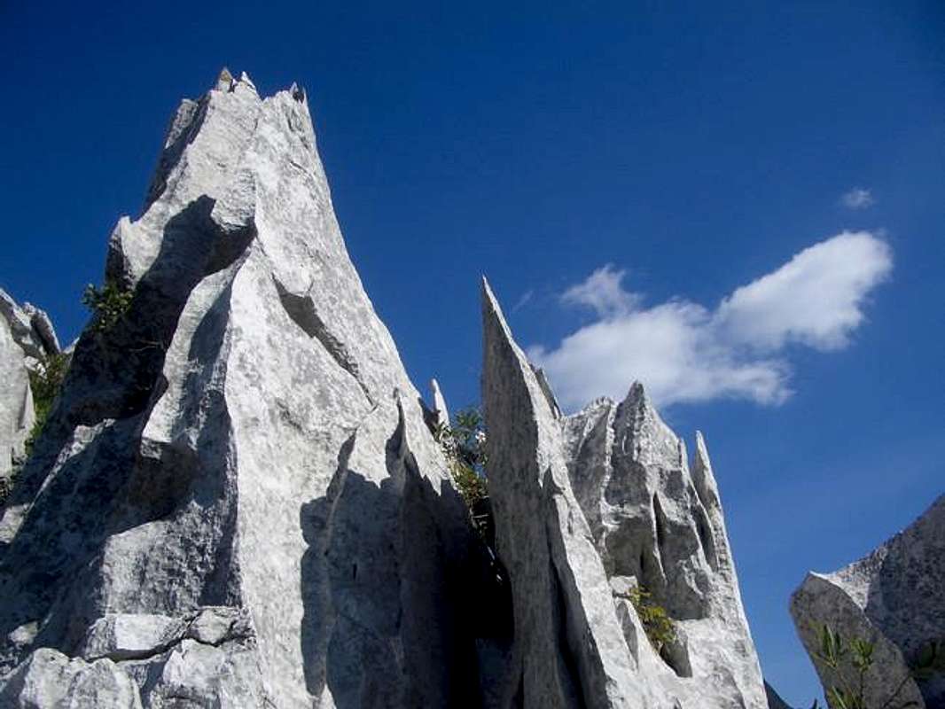
 |
 |
 |
 |
 |
When To Climb
General
Like the other mountains in Velika Kapela area (Bjelolasica, f.e.), Bijela and Samarske stijene are also known for lots of precipitation all year round (rain and snow), especially in winter, spring and fall – more than 3,000 mm a year.
You can climb this mountain in all periods of the year, although winter conditions can make you more problems, because of the thick snow layer and inaccessible approach roads in the area. Also in other wet periods of a year because of clouds and fogs you will be very often left without nice views from the mountaintops.
If you plan a car approach the foot of Bijele and samarske stijene you should be aware that some forest road from Jasenak to Tuk Mrkopaljski and to Begovo Razdolje are impassable from December until April/early May because of snow.
Winter
Winter is a "peaceful period“ when you will rarely meet people trying to climb Bijele and Samarske stijene. The winter outfit is obligatory. On an average winter there will be from ½ m to 1 ½ of snow along your way and ever more than that between rocks in rocky clusters.
Spring, Summer, Fall
In early spring you will still run into snowdrifts, especially in shaded areas and between rocks.
Late spring and early summer are the best periods to hike in the area. Late spring is especially pleasant and appropriate period to visit when the weather is fine and vegetation blossoming.
Generally, the mountains in the area are mostly visited from May until September – during so-called „- berry times“ (when you can pick up raspberries, blueberries and strawberries along your way). Meadows from Velika Javornica to Stalak are full of raspberries in August, and a few meadows between Bijele and Samarske stijene and Bjelolasica mountain are known for blueberries.
Spring and fall can have lots of rain but also the best views from the summits of Velika Kapela group.
Even the summer is the driest period, because of some rainfall and lots of woods the air can be more humid and views less beautiful than in other periods of a year.
Also despite lots of precipitation, the mountains in the area are made of limestone which does not keep the liquid at the surface, so as a precaution take all the water you need with you, during all periods.
 |
 |
 |
 |
 |
Camping
It is not usual to camp in the mountain area of Bijele and Samarske stijena and Velika Kapela group because you can find a satisfactory network of shelters/bivouacs or mountain houses at a day of half/day´s walk distance.
In strictly protected area of Bijele and Samarske stijene camping outside mountain hut perimeter is strictly forbidden. OK, no one can ever stop you from putting your tent along your way if you have to stop there overnight, but people usually plan their hikes in a way that they walk from hut to hut, where they can find modest accommodation.
Tents are mostly used when existing shelters or mountain houses are full (which does not happen very often), and then by asking the maintainer of the object (if there is any) to camp in the vicinity of the object.
1. Accommodation on Bijele and Samarske stijene:
Mountain house“Bijele stijene” (1,280 m), situated in Bijele stijene (White Rocks) subgroup - 10 minutes from its highest peak; minimum 1 h away from non-paved road Jasenak-Mrkopalj, 3 hours away from Bjelolasica summit by foot; maintained by Mountain club “Kapela” from Zagreb, electricity from solar panels, a well with filtered water. Usually is open on weekends from late spring to early fall. For other information: Antun Pavec: ++385 1 6555440, ++385 1 3695173 or antun.pavec@zg.htnet.hr and Slavko Ferina: ‘++385 1 3738412, ++385 1 3722716, or slavko.ferina@pliva.hr
Mountain shelter/hut “Miroslav Hirc” (1,280 m), on Bijele stijene 1 minute from mountain hut “Bijele stijene”. Open all the time. No electricity. Water by nearby mountain hut. Can take up to 25 people.
Mountain shelter/hut “Ratkovo skloniste”, on Samarske stijene (1,200 m); around 3 hours away from Mountain hut «Bijele stijene» on Bijele stijene, 3 hours away from Bjelolasica summit and 30 min away from non-paved road Jasenak-Mrkopalj; maintained by Mountaineering club “Velebit” from Zagreb. Open all the time. Water from well (filtered water). No electricity.
2. Accommodation in the vicinity of the mountain:
"Planinarsko skloniste (mountain shelter) Jakob Mihelcic”, at 1,460 m, on Bjelolasica mountain, 3 hours away from Bijele stijene. Close to the summit of Bjelolasica mountain, just below the main mountain ridge; maintained by mountaineering clubs “Kapela” and “Vihor” from Zagreb. The shelter is open all the time for everyone. It can accommodate cca 10 persons, no supplies, no electricity, water from local well (filtered rainfall water), small stove (handle with it with care, it's partly broken).
Contact persons are Damir Gross, ++385 1 3733513, ++385 1 4808215, ++385 91 5752824 or Vlado Horvat, ++385 1 3778696, ++385 1 3394242
Situation in April 2005: beds were missing soft pads so prepare for uncomfortable sleep! Hope the maintainers will take care of this problem as soon as possible!!!
Mountain Hut Jancarica (1,236 m). This is a wooden hut with electricity, kitchen and bedroom for cca 18 person. A well with filtered water stands by the hut. It is not supplied and usually is locked, keys are being kept by maintainers Mountaineering club “Bijele stijene” from Mrkopalj. If you plan to use the house you should contact Branko Blažević: ++385 51 833248, ++385 51 833063.
Next to Jancarica Hut is a small, all the time open, wooden cottage/shelter with places for 7 persons and a small stove. No previous arrangements are necessary for this shelter.
3. Accommodation at other locations:
Mountain House „Bijele stijene", in Tuk Mrkopaljski (875 m) 3 1/2 hours away from Samarske stijene. This is a solid structure situated in the village itself, just by the main road. It has electricity, water, and a kitchen with dishes to choose from. Around 52 persons can find accommodation here (in 10 small rooms and more dormitories).
The telephone of the House is ++385 51 833-278. The House is opened all the time and is maintained by Mountain Club Bijele stijene from Mrkopalj.
Mountain House „Klek“, (at exactly 1,000 m alt.), It is situated on a small ridge south of Klek´s summit - 20 minutes away from it. It was built in 1958. Nice views from the house. Open on weekend all year round. It has around 40 sleeping places, water supply and electricity. Contact persons are Damir Gross, ++385 47 531206, Miljenko Pavesic ++385 47 522384 (situation 2004); 6-7 hours away from Bijele stijene.
4, Commercial accommodation and good information sources at:
HOC Bjelolasica - Croatian Olympic Center Bjelolasica is a sports and tourist center situated at the northeastern foot of Bjelolasica in Vrelo village. Besides accommodation possibilities, it has developed a wide range of outdoor activities including ski, mountain biking, hiking, riding, adventure races, team building, alpinism and more.
More at:
HOC Bjelolasica - accomodation and HOC Bjelolasica - homepage also HOC Bjelolasica – Hotel Jastreb Begovo Razdolje
You can also find accommodation in private houses in Jasenak village. Info at Tourist Association of the town Ogulin
Mountain Conditions
You can find information on weather conditions in the area from standard weather information sources for Croatia (DHMS – The Croatian State Hydrometeorological Institute). The nearest official meteo-stations for Bijele and Samarske stijene are Ogulin, and Delnice. But be aware that Ogulin is at the edge of Velika Kapela group and sometimes the weather can differ here from that on Bijele and Samarske stijene that lay in the heart of the mountain group. Many times Ogulin has better weather than Bijele and Samarske stijene.
General weather info at:
DHMZ-Weather-english page
DHMZ-forecasts in English
DHMZ-local measuring points
Snow conditions at: DHMZ-snow conditions Begovo Razdolje, north-west of Bjelolasica is closest measuring point (at 1,060 m)
Maybe the best actual info on weather on Bijele and Samarske stijene can be found at Vrelo, HOC Bjelolasica-weather, which is a small measuring point in «Bjelolasica Tourist Center» in Vrelo village (situated north of Bijele and Samarske stijene behind Bjelolasica mountain).
Routes, trails, paths
There are more paths over Bijele and Samarske stijene, „the local ones“ that show you many hidden corners of B&S and the other paths that are also parts of other long-distance hiking trails.
So when climbing Bijele and Samarske stijene you will notice some abbreviations next to standard mountain marks. These letters belong to mountain trails with sections that cross over Bijele and Samarske stijene. One of those trails (MPP) passes through Bijele and Samarske stijene mostly, while the others go much further connecting wider mountain areas of Croatia.
Those trails and the signs you will notice are:
MPP - Mrkopalj mountain trail (Mrkopaljski planinarski put),
KPP - Kapela mountain trail (Kapelski planinarski put),
GPP - Gorski kotar mountain trail (Goranski planinarski put).
If you continue from Bijele stijene over Velika Javornica in direction of Kolovratske stijene (southwards), you could continue further to the south to Vratnik pass above Senj and to Oltari village. The section from Kolovratske stijene to Oltari is called SPP - Connecting mountain trail (Spojni planinarski put). From Oltari you could continue your hike further along magnificent Velebit mountain by taking VPP – Velebit mountain trail (Velebitski planinarski put).
There are also some other nice marked path over Bijele and Samarske stijene, taking you to the most hidden parts of the Rocks. The most beautiful one is so-called Vihoraski put (Vihor path) – named after „Mountain club Vihor“, whose members marked an astonishing trail through all those rocky limestone clusters that make Bijele stijene mountain ridge, and the trail finally takes you to Samarske stijene. (you need 3 ½ hours to cross just 2 kilometers!).
I will try to describe some of these mountain trails when I (I hope) put Velika Kapela GROUP page on Net.
Ljuska area in Bijele stijene, with a view on mountain Bjelolasica - in distance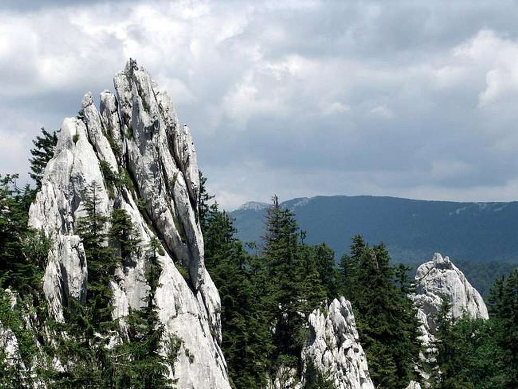
 |
 |
 |
 |
 |
Distances
Jasenak-Begova staza- Rusov jarak: 2 h 30 min - 3 h
Jasenak Begova staza-Mlecikov lug-Samarske stijene (Ratkovo skloniste – mountain hut): 2 h 30 min - 3 h
Vrelo-Vrelce-Rusov jarak-Bijele stijene: 4 h
Vrelo-Gomirkovica-Velika Vrata-Bijele stijene: 5h
Begovo Razdolje – Samarske stijene summit: 3 h 30 min
Bjelolasica-Velika Vrata-Boce-Bijele stijene: 3 h 30 min
Bjelolasica-Summit of Samarske stijene-Ratkovo skloniste mountain hut: 3 h 30 min - 4 h
Bijele – Samarske stijene 3 h – 3 h 30 min
 |
 |
 |
 |
 |