-
 44983 Hits
-
 80.49% Score
-
 12 Votes
|
|
Mountain/Rock |
|---|---|
|
|
42.23530°N / 18.19100°E |
|
|
5738 ft / 1749 m |
|
|
Overview
Other Links: 4 March, 2nd 2010. Lovćen National ParkAm I on Paradise or on the Moon?
(George Bernard Shaw, his impressions during his visit to Lovćen)
*Lovćen (read Lovtchen, where “tch” is like “tch” in hitch).
This montain is a symbol, natural, historical and cultural - both of Montenegro (area is known as a craddle of Montenegrin statehood) as of Montenegro´s most famous son Petar Petrovic II Njegos, a poet, philosopher, prince-bishop and statesman from 19th century, a prominent member of old Montenegrin rulling family Petrovic, originating from village of Njegusi, at the foot of Lovcen mountain. Today, Njegos is buried in a sarcophagus in a Mausoleum atop Lovćen mountain.
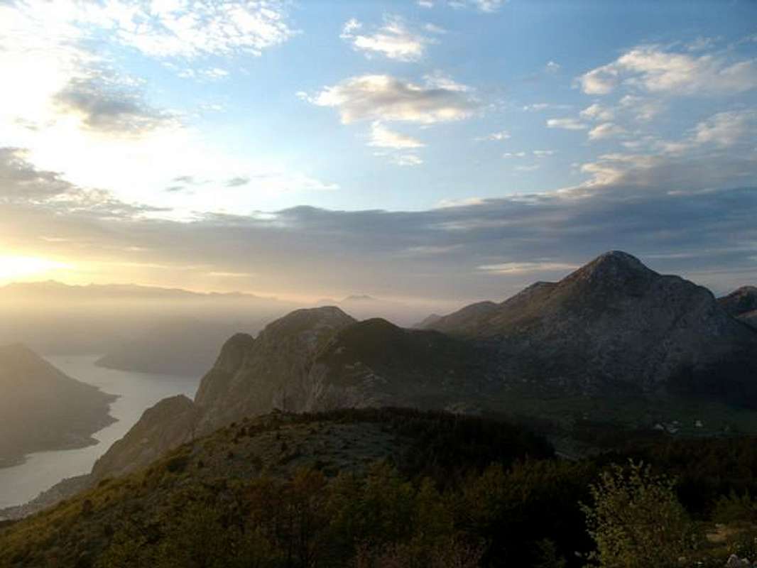
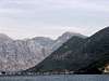
Lovcen is a mountain in Dinaric Alps, that rises steep from the edge of Adriatic basin, above coastal Montenegro, enclosing eastern and southeastern parts of magnificient Boka kotorska bay. And Lovcen itself, is bordered by Boka kotorska from west and NW; on its SW side lays the open sea, and Budva bay is on the south. So, because it is surrounded by the sea from more sides it is in real sence the mountain of Dinaric maritime chain.
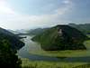
To the east and south-east, slopes of Lovcen stretch all the way to carstic field of Cetinje and hills over Rijeka Crnojevica river, a tributary of Scutari (Skadarsko) lake. To the north and NE Lovcen is spreading into rugged Montenegrin carst, area difficult to live in, very often called “the stony sea” – and those words are telling everything for themeselves. This is probably the sight G. B. Shaw was thinking of when he was mentioning “the Moon”.
The morphology of Lovcen shows more faces. From the coast the mountain rises very steep. From the Bay of Kotor especcially, it rises as a huge stony wall (it rises 500 m on each 1 km of width). The mountain here falls almost directly into water. Around altitude of 900 m there is a change in structure and the slopes above this area rise more gentle.
From the hinterland side, the mountain rises more gentle and gradually.
Like other mountains in the area, Lovcen too has limestone stucture. Its relief and surface shows elements of both carstic and glacial influences - glaciers were present here during Pleistocene period, and lots of precipitation has its role in making&shaping of carstic relief.
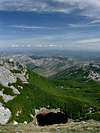
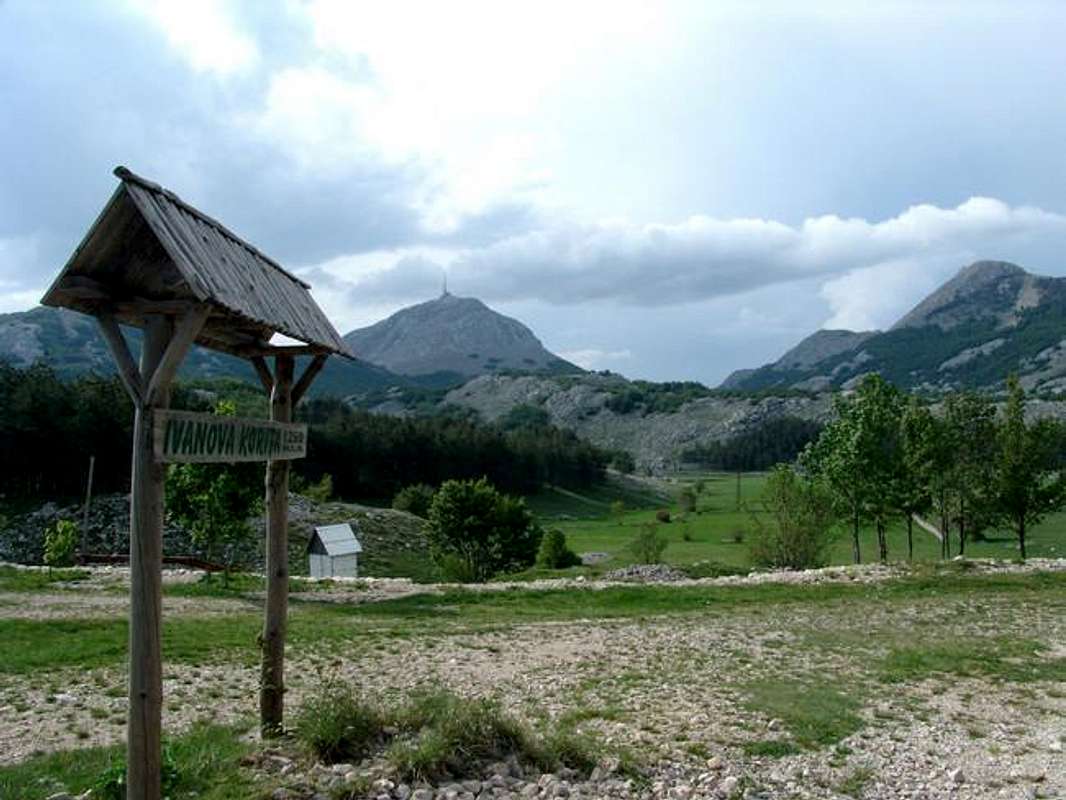
Around the summits of Lovcen there are deep carstic depressions (deepest in the wider area) and lots of crevices, chasms and other carstic forms. Some of this depressions (basins) are up to 200 meters deep (Kuk, Bizaljevac, Vuci do, Veliki and Mali Bostur), while the others are shallower. One of those are Ivanova Korita and Dolovi which are also the vastest basins of central part of the mountain. The most visible traces of glaciation can be found on nothern parts of the second highest summit Jezerski vrh.
Thanks to its position and morphology Lovcen receives large amount of percipitation, like Orjen mountain, its first neighbour from the NW. With and average of 3500-4500 mm of percipitation per year (on Orjen even more) this area is considered to be one of the Europe´s wettest (together with Norway´s coast and south part of Bay of Biscay) parts. The reason for such large amount of percipitation is that Lovcen is very often exposed to warm humid winds from the Adriatic sea, that crash suddenly with cooler air above maritime chain of mountains and cause condensation processes.
But because of limestone structure, very little from that liquid stays on the surface, although there are areas where you can find abundant water springs (like on Ivanova korita or at the foot of the mountain, at the sea level).
The view on two highest summits of Lovcen mountain, Stirovnik (1,749 m, left) and Jezerski vrh (1,657 m), as seen from Ivanova Korita (1,261)
The geographical position of Lovcen and its morphology are the main reasons why the mountain has a mixture of Mediterranean, moderate-continental and mountain climates. On its carstic maritime foot of the mountain (podgorina) the town of Kotor has average year temperature of 15,4°C and Budva 17°C; Lovcen´s carstic foot of the mountain in hinterland (N and East side of central Lovcen area) has yearly average of 10,5°C, and Ivanova korita which lays under highest central summits has a year average of 5,9°C.
Central Lovcen area
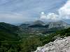
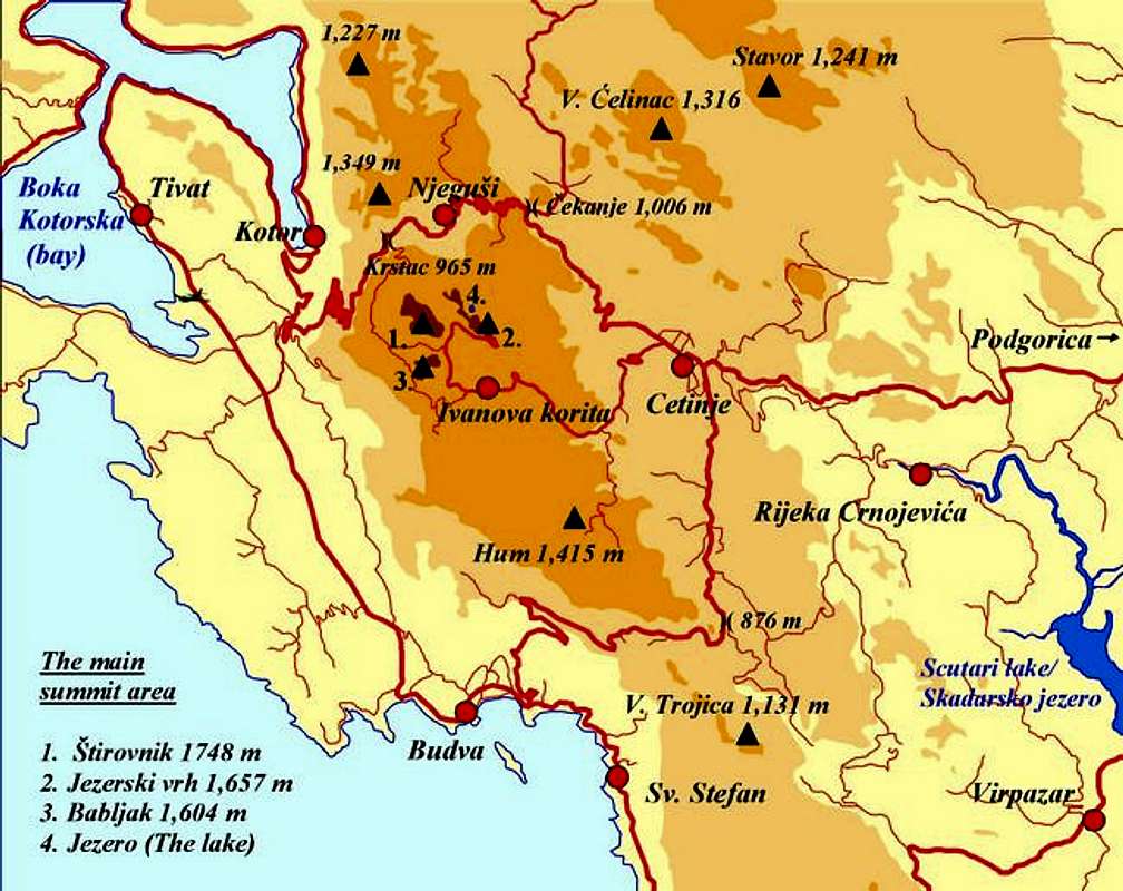
Although Lovcen massif covers wider surrounding area (more carstic fields, basins and summits), under the name of Lovcen the most of the people would consider only the highest central area where three of its highest summits stand. Even further, when you´ve mentioned the name of Lovcen throughout history, even until today, the most of people would think on Lovcen´s second highest summit only.
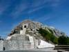
Jezerski vrh (1,657 m, N 42,2559 E 18,5032, Lake Peak) is the name of this summit. Although it is the second highest this is a „real Lovcen“ for many. It got its name after the nearby lake (the word for lake in local language is jezero). The summit is a stony elongated ridge, slightly curved. It reaches 1,657 m on southern part and 1,584 m on northern. A road from Ivanova Korita goes almost to the summit, where the main attraction is a Mausoleum dedicated to Petar Petrovic II Njegos. Because Jezerski vrh is open to public, when one talks about panorama from Lovcen, this would mean a view from Jezerski vrh. And from this summit you can see huge massif of Orjen mountain, part of Boka kotorska bay, Montenegrin coast hinterland, central Montenegro, Rumija mountain to the south, Prokletije mountain chain, other mountains of Montenegro (Garac, Prekornica, Vojnik, Njegoš, Komovi, Durmitor), Skadarsko jezero (Scutari lake) and the town of Cetinje. They say you can see the coast of Italy, on the opposite side of the Adriatic, on clear days.
Lovcensko jezero (Lovcen Lake) (1,620 m; the Lake, transl.) a small lake that lays under eastern rock of Jezerski vrh summit, just bellow the Mausoleum.
Stirovnik (N 42°23'53'', E 18°19'10'', read Shtirovnik, where „Sh“ is like „sh“ in bush, an „i“ like „i“ in lips) Although the highest summit of Lovcen with 1,769 m, it has never gained the popularity and „image“ as Jezerski vrh had. Now on Stirovik is a telecommunication tower and the access to the summit is not allowed.
Babljak (1,604 m) is the third largest summit in central Lovcen area, situated just south to Stirovnik.
Trestenik (1,489 m, read Treshtenik) the lowest of summits in central area, situated south of Jezerski vrh and Ivanova Korita.
The mountain is easy accessible, especcially when you come to the area by car. Beside the approach by the road to the summit, you can also climb Jezerski summit by foot, on half-day or one day hikes (from Kotor, f.e.). Most of those hiking trails follow former shepherds´paths but they are not marked (or were marked a long time ago and marks have already faded) and they are choked with rank vegetation today. Those trails start in Njegusi village, Krstac pass, Bukovica pass (on a road from Njegusi to Cetinje), or from Ivanova korita.
The highest parts of Lovcen was declared a national park in 1952. the National Park cover 6,220 ha. Because of different climatic influences and geomorphology the area has very interesting biodiversity – more than 1,300 plant species, of which many are endemic or relict. Steep west slopes of Lovcen are covered with oak trees and underwood in lower zones, and the milder slopes on E in hinterland are predominantly covered with beech-trees. Historical and cultural importance of the mountain were also important in bringing decision to proclaim Lovcen a National park. In the area of National park you will be able to find some old villages and katuns (clusters of shepherds summer huts). Administrative center of NP is in Cetinje town.
 |  |  |  |  |
Getting There
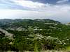
View from Jezerski vrh (summit, 1,657 m) in northern direction. Just bellow NW rock of the summit lays small Jezero (the Lake, 1,620 m). Further in the distance a part of Njegusko polje (Njegusi Field), vith the village of the same name can be seen. General GeneralAlthough the mountain is easy accessible because its central summit area and other parts are connected with a relatively good road network (paved and non-paved roads) the real problem can occur if you depend on public transport only, because it is not yet developed. 1. To get to the mountain by car 1.1.To get to Cetinje You can approach Cetinje from the capital Podgorica (33 km) by main road via Meterizi, but you can also take off the main road and continue to drive to Cetinje via Rijeka Crnojevica village and river valley, and experience this nice panoramic road. The approach to Cetinje from he Adriatic coast, from southern directions, is usually done by taking a road from Budva to Cetinje (32 km). You can also approach Cetinje from Central Montenegro, from Niksic (via Cevo and Resna, 75 km from Niksic), or from Herzegovina region from Trebinje, via Grahovo and interesting region of Cuce „a realm of carst“; 100 km from Trebinje to Cetinje). If you coming from the Adriatic coast , from northern directions via Boka kotorska bay,in Kotor you take the so called „Lovcen road“ to Njegusi village (from Kotor to Cetinje is 45 km). 1.2.To get to Ivanova Korita You can chose two roads to get there. The main road comes from Cetinje. In Cetinje head north of town center in direction of Njegusi, but in NW part of Cetinje be ready to turn left to a branch off road. This road will soon get you out of town, and it will start to climb in serpentines, then in many curves it will take you to Ivanova Korita (14 km from Cetinje) Another road is the recently paved one, it starts at Krstac pass and encircle Lovcen (Stirovnik summit) from west. This is a road with some of the best views on Boka kotorska bay! 1.3.To get to Njegusi Only one road passes through Njegusi, it is Kotor-Cetinje road, so you can approach Njegusi village from direction of one of those two towns. 1.4. To get to Kotor If coming from north you will certainly use the Adriatic scenic road that runs along all eastern Adriatic coast from Croatia into Montenegro. From Dubrovnik to Kotor is 87 km. 2. To get to the mountain by bus There are no regular bus lines to Ivanova Korita or Njegusi, neither from Cetinje nor from Kotor. If you are in need of transportation you have to arrange a rent-a-bus (for a group f.e.), taxi or another vehicle to take you there. The nearest bus stations to Lovcen are Cetinje, places along bus line from Cetinje to Niksic and other places along the Adriatic road, including Kotor and Budva. 3. To get to the mountain by train There are no rail lines in the vicinity of Lovcen. If planning to come by train, the nearest you can get is Podgorica or Bar, which are stations along Belgrade-Bar railway. From Podgorica you can take a bus or rent-a-car to Cetinje. From Bar you can take a bus to Budva, or Kotor, and – depending on your plans – to Cetinje. 4 To get close to the area by plane The most appropriate way to arrive by plane is to Podgorica or Tivat airports. Those airports still have no web-site so try to get info on the sites of two biggest airline companies that operate to and from Podgorica or Tivat: Montenegro Airlines JAT – Yugoslav Airlines Belgrade Airport - for flights between Podgorica and Belgrade and between Tivat and Belgrade. The other possibility to arrive by plane is via Dubrovnik Airport (in Croatia). From Cetinje to Podgorica Airport (45 km), Tivat Airport (45 km), Dubrovnik Airport (115 km). 5. To get to the foot of the mountain Around the mountain´s highest and most visited part there are few encircling roads Cetinje-Njegusi, Cetinje-Ivanova korita-Jezerski vrh (the Tomb), and Ivanova korita-Krstac. You can approach the mountain from all sides from these roads. Villages Njegusi and Ivanova Korita are already at the foot of the Lovcens highest summits.
Red TapeLovcen is a National park and until the season of 2004 the fee of 2 euros had to be paid when entering the Mausoleum only. But since June 2005 the National park service has started to charge the entrance to National park on entrance point situated in Bjelosi on Cetinje-Ivanova Korita road. Here you will get the ticket at price of 0,50 euro per person. Another entrance point is planned for visitors that come to the Park from direction of Krstac pass.If you plan to climb Jezerski peak from NE side you are obliged to contact the National Park Security Service in advance. Contact telephone is ++381 67 815 280. Other warnings visitors of Lovcen should be aware of include: plenty of snakes in the area especially in summer, summer heat, sudden weather changes, hiking when the fog is present or hiking when cloud cover your route, lack of signs and non-existence of mountain-marks.
When To ClimbSpring and autumn are the best periods to climb Lovcen. The mountain is still quiet (touristically) untill late spring. The road to the summit of Jezerski vrh can be close late into may because of remains of snow on the northern side of the summit. The season begins in June with the beginning of summer. Summer daily temperatures from June to mid September can be very high despite the altitude. You have to bear that in mind especcially when climbing from the Adriatic coast, like from Kotor to Krstac pass to Lovcen, via old caravane route. The temeperatures on Ivanova Korita and central summit area are somewhat lower (especcially in shades), but on the sunny sides you will still feel summer heat. Heavy rains with lots of lightning are possible also in summer.Fall, winter and spring can bring lots of rain, snow and cloudy or foggy days, all this thanks to geographical position of Lovcen and climatic conditions that prevail here. CampingThere are no classical mountain huts that are open and easy accessible to offer you much needed rest.On Ivanova Korita there are some possibilities to oversleep but most of the time it includes some pre-arrangements. (I´ve found that on Ivanova Korita there is a private mountain house, open when arranged with the maintaineer Mrvaljevitch from Cetinje (tel ++381 69 027 052) The same applies if you plan to find accomodation in Cetinje or Njegusi. Cetinje has two hotels, Njegusi has no accomodation at the time. Probably the best way to find accomodation is to ask people passing by. You will find less problems with (commercial/private) accomodation along the coast (Kotor, Budva and other places). Recent news: There is a plan to establish a National Park official House on Ivanova Korita and a camping next to it.
Mountain ConditionsThe nearest permanent and official weather stations are Cetinje, Kotor and Budva. Since Budva and Kotor are situaded by the coast at zero altitude, you have to be aware that despite theirs vicinity to Lovcen montain the weather at the coast can differ from that one in the high mountains above, many times drastically. But the forecast for Kotor or Budva can be usefull to you if you plan to visit Lovcen´s maritime slopes.So, most of the times for Lovcen region the most usefull would be Cetinje´s weather reports and forecasts, as well as Ivanova korita and Njegusi ones. Weather information at: Ivanova Korita at Accuweather Cetinje at Accuweather Njegusi at Accuweather Kotor at Accuweather Budva at Accuweather Other local weather info (sorry they don´t have English pages) at: Meteo-CG (there go to „Analiza vremena“, then under „Cetinje“, or other town you need, take „najsvjeziji podaci (the latest situation) or meteogram (with weather forecast). You can also look for „sjutra“ (tommorow´s forecast)). I could not find any live web cameras in the area to look at live weather situation.
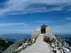
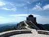
Petar Petrovic II NjegosPrince Petar Petrovic II Njegos (read: Petrovitch, and Nyegosh) was born in 1813 in the village of Njegusi on Kotor-Cetinje road. His house of birth is now a Museum. Njegos is the most prominent member of Petrovic-Njegos former Montenegrin rulling dynasty. He was appointed a bishop in 1833, in Snkt. Petersburg. He reigned Montenegro from 1830 to 1851. Njegos modernized old state (dukedom) of Montenegro by establishing the Senate with executive power, introducing taxes, formation of professional armed guard and working on rapid educational and cultural development of Montenegro. Petar himself knew five languages, he read Shakespeare, French philsophers and German classical writers in original, and he became Montenegro´s greatest poet. He is author of the most patriotic Montenegrin epic „The mountain Wreath“ („Gorski vijenac“). He died of tuberculosis at the age of only 38.The MausoleumThey say it is the highest Mausoleum in the worldBefore his death in Cetinje, in october 1851, prince-bishop Petar Petrovic II Njegos expressed his wish to be burried in a chapel on Jezerski vrh (Lake peak) on Lovcen mountain. Until this time a small chapel already stood there, the one that Njegos had built in 1845 on behalf his predecesetor bishop Petar I Petrovic Njegos (his uncle, who brough him from village as a boy and educated him for his inheritor). After Njegos´death Montenegrins did not want to burry Njegos on this lonely summit affraid that the enemy Turks may come and ruin the grave. But 4 years later, in 1855 his bones, according to Njegos´last wish, were brought and burried on Lovcen. Turks never maked it to ruin this symbol. But during WW1, when they reached the area, then winning Austro-Hungarians „dedicated“ the first plotoons to the chapel. When they finally conquered Lovcen in January 1916 they destroyed the chapel to the ground. Austrians had plans to build large monument at the same place dedicated to their victory, and they invited tenders for the monument. The inhabitants of Cetinje managed to save remains of Njegos and transferred them to Cetinje. The plans for this new monument had never realized. After WW1 was finished, in 1925 a new chapel was erected and Njegos was burried in it, for the second time. During this period an idea to build a monumental mausoleum occured and accordng to wish of then Yugoslav king Aleksandar Karadordevic, a famous Croatian sculptor Ivan Mestrovic was invited to make plans of Mausoleum. This project was never realised, because of financial reasons. In 1951, on 100th anniversary of Njegos´death the initiative to built a mauseoleum came out again. The Governement of the Republic of Montenegro asked the sculptor Mestrovic for a project of a mausoleum, for the second time. Mestrovic, who then lived in Syracuse, N.Y., U.S. accepted the offer with a great joy. He asked an architect from Zagreb to visit the mountain and collect more information needed for the project. After 8 months the plans were finished and the building of the Mausoleum started. As admirer of Njegos and small Montenegrin folk that suffered hard during history, mostly because of bloody fights for independence agains huge Turkish Empire, Mestrovic did not ask for a money for the project, but just a piese of famous Cheese and smoked ham (prshut) from Njegusi village. Mestrovic made schetches of Mausoleum – inspired by that of the Persian king Cyrus - he also made schetches for sculptures of Njegos and 2 cariathides (presenting 2 Montenegrin women) and sent them back to homeland where other sculptors carved them in black granite from Jablanica (in Bosnia&Herzegovina). In September of 1957. the monuments were brought to Cetinje. But still a building of a Mausoleum had to be built. Works on the building started in may 1970. More than 11,000 tons of stone had to be brought to the summit, including huge sculptures weighting tons (up to 40 tons a piece!). And the building on this place was a hard work. Njegos once wrote: „The weather on Lovcen changes 6 times and day, and lightnings are music to the mountain“. Very often workes have to hide from thunders. Even today the summit is equiped with special lightning-rods. The Mausoleum was finally finished in 1974. Visiting the Mausoleum You can approach the Mausoleum by road or by hiking paths. On 20th kilometer from Cetinje (via Ivanova Korita) you arrive at rounded car park (at 1,574 m alt.). From here a 125 m long tunnel with 461 steps (60 meters up), that is digged under the summit of Jezerski vrh, will bring you to the platform in front of Mausoleum. The Mausoleum is 37 m long, 15,4 m wide and 11 m high. The platform will take you to the entrance of the Mausoleum. First you enter the atrium 16 m long, all of granite, with 5 columns on both sides, each weighing around 10 tons (4,33 m high). In the middle of the atrium is a well with drinking water. At the end of atrium before the entrance to the Chapel you will notice 2 chariatides (4,33 m high, 8 tons heavy) in dark granite from Jablanica that represent two Montenegrin women in folk costumes. Behind chariatides there is a Chapel, 10 m long, made of white marble from Boka kotorska and island of Brac (in Croatia). In the Chapel stands a huge sculpture representing Njegos (3,74 m high, weighing 28 tons) with an eagle above its head. Njegos is dressed in Montenegrin folk costume. From the other side of Mausoleum behind the Chapel there is a small room with a sarcophage with remains of Njegos. This sarcophage is modelled on old montenegrin tombs, and decorated with Montenegrin cross, coat of arms and a sign: „Njegos 1813-1851“ From the other side of the Mausoleum there is a rounded sighsteeing platform, modelled on Dinaric style (wheat/grain) treshing-floor (gumno).
Ivanova korita (1,255-1,261 m)Ivanova korita is the largest of Lovcen´s basins, with mountain climate and plenty of cold springs. Since 1929 here exist a mountain medical establishment, sanatorium for lungs and pneumatic diseases. Today there are more houses on Ivanova Korita, including childrens recreation center. Passing through Ivanova Korita is the most popular way of visiting summits of Lovcen.Ivanova korita got its name after Ivan Crnojevic (former ruler of Montenegro).
Njegusi (880 m-940 m)Pictoresque mountanious village (in fact it consists of more hamlets) on Cetinje-Kotor road in Njegusko polje - a carstic field (880 m-940 m) surrounded with mountains from all sides, except on western side where Krstac pass is situated (965 m). In history, an important trade path from Kotor, at the sea coast, to hinterland via Njegusi and to Cetinje passed over Krstac, and todays modern road is following the most of this historical route.Njegusi as a settlement is mentioned for the first time in 1453 but it was established even before that time, because shepherds from Zeta valley (where todays Podgorica lays) had their summer huts here (like on highest central Lovcen, too). Njegusi are famous for their famous Cheese of Njegusi (njegushki sir), dried sheep meat (koshet) and Njegus ham (njegushki prshut). It is here from Njegusi from Erakovic brotherhood that ortodox-bishop (vladika) Danilo a founder of rulling Petrovic dinasty originated. Houses where Petar Petrovic II Njegos (in halmet Herakovici) and last ruller of Kingdom of Montenegro Nikola I Petrovic were born, are museums today. When coming from Njegusi to Krstac pass and continuing upwards to hills around Krstac, or downhill by the road to Kotor, you can experience wonderfull views on Boka kotorska bay, Orjen mountain and many serpentines of Kotor-Cetinje road.
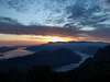
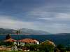
Boka kotorska baySunset over Boka kotorska bay, from NW slopes of Lovcen above Krstac pass (965 m, right on the photo). The mountain in the background is Orjen (1,893 m) |