Traverse Specifics
Traverse Distance:16 miles
Duration:14.5 Hours with hour lunch
Total Vertical:7000 feet
Data below is based on route lines and ground distance calculated in topographical program.
Blake Slide
Minimum Elevation: 2680’
Maximum Elevation: 3800’
Change in Elevation: 1120’
Length: .45 mile
Nippletop Slide
Minimum Elevation: 2870'
Maximum Elevation: 4300’
Change in Elevation: 1430’
Length: .625 mile
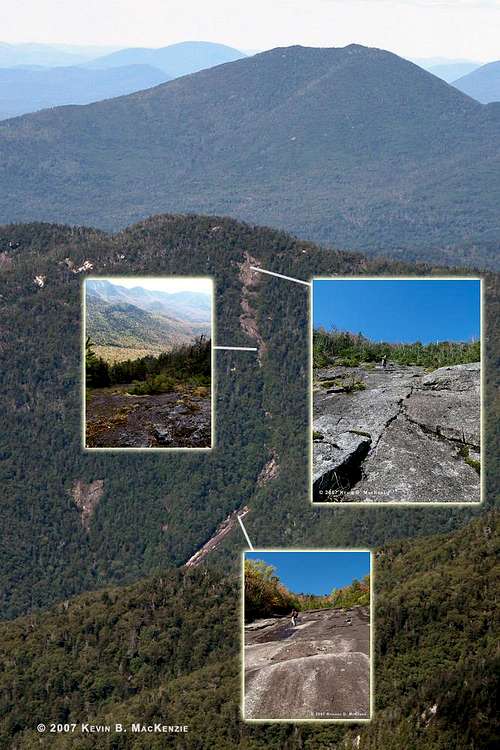
Colvin,Blake and South Blake
My week prior to Saturday entailed battling allergies and other health issues so I prayed that I’d be well enough to hike on the 29th in order to capture some pics of the fall foliage while having another “misadventure” with WWBF. On the evening of the 28th, I didn’t think my participation would happen, but I begrudgingly awoke at 5:30 a.m. and committed myself. I was less than enthused about seeing the sunrise on the weekend. We arrived at the trailhead and began the traverse at about 6:30 a.m. Our goal was to hike Colvin, Blake, Blake Slide, Nippletop Slide and Dial. The temperature was firmly in the fifties and comfortable in short sleeves. Morning fog clung to some of the mountains, but the glowing sky threatened to burn it off in short order. The ¾ mile walk up to the Ausable Club gate found me at a slow pace compared with WWBF who loves to start at a faster clip. I chuckled as I signed us in and wrote our itinerary. It’s not a normal day-hike for most people.
We’d walked the dirt road many times in the same early morning stupor, but I was still off pace and tired. Somewhere before the Gill Brook trail, I found my pace and fell into it. The mileage clicked away steadily. This was surprising since it usually seems like an endless trek up a constant grade. Our first rest, if you can call exchanging glasses for sunglasses a break, was at the intersection of Nippletop/Colvin about five miles into the hike. After a minute or two we pressed on up the steep trail to the first of the eight false summits of Mt. Colvin. I grumbled at the multiple cols and subsequent ascents. The summit ridge was under bombardment from steady winds from the southwest.
I wanted to take pictures of Nippletop Slide from Colvin’s summit for this report. Colvin allows a close head on view of the scar, but the angle of the sun hid the mountain in a shadow of its own making. After a five minute respite, we continued the journey to the Colvin/Blake col. The south side of this mountain is a steep descent with several small scrambles. Morning dew coated everything and turned roots and rocks into treacherous slip-n-slides. I shimmied down a crack in a twelve foot rock face and allowed myself a butt slide to the ground…a mistake that I executed without grace. I hit the ground hard with my right leg and failed to stop the momentum of my body which twisted farther thus tweaking my knee. This problem would become more troublesome on Nippletop’s summit.
We continued without relent through the col and up Blake’s steep path. Blake was and remains one of my least favorite mountains, but one that I climb every year for some reason or another…a running joke. Suddenly, the slide headwall came into view from a knoll just prior to the summit. It appeared to begin just off the east side of the ridge and just prior to South Blake’s summit. A minute later I was standing on the summit. It was 10:00 a.m., not bad for a start time of 6:30 a.m.
We descended from the summit proper and began our approach to the slide when WWBF stated that we should also summit South Blake, one of the 100 highest peaks in NY since we were mere minutes away. A little extra effort now would prevent a seven mile trip in the future should either of us decide to try and summit the “100”. This isn’t a goal either of us aspires to complete, but it only made sense. Besides, it gave us an opportunity to survey all the possible entry points to the slide from the little used trail.
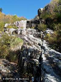
Blake Slide
![Blake Slide - Mid Slab]() MudRat on the middle portion of slab after ANOTHER mid-slide bushwhack.
MudRat on the middle portion of slab after ANOTHER mid-slide bushwhack.![Blake Slide - Upper Headwall]() View of the upper slab on Blake immediately emerging from the bushwhack.
View of the upper slab on Blake immediately emerging from the bushwhack.
I’ve taken several recon photos from Dix and other mountains over time in anticipation of a trek down (or up) Blake Slide. The headwall begins about 100 feet off the trail and slightly before the summit of S. Blake. I thought the slide was mainly rubble based on my photos and satellite images. Oh, how wrong I was. At the top it hooks slightly north before a bend slightly south. It was nothing like I expected. After climbing S. Blake, we turned around and walked until we found an obvious col with a large amount of blowdown. We should have entered farther south by about 100 feet, in retrospect.
We marched into the blowdown. I was careful to walk on top of the old trees and extra careful to test them with my weight since I was at least six feet off the ground several times as I redirected myself south to find the headwall. I knew that we were slightly off nearly immediately. Suddenly, I heard, “Kevin wait”. I stopped after exiting the horrendous blowdown and waited in the dense spruce as I heard WWBF yell, “What the hell did you lead me into!?” I was silent while choking back laughter as I once again (like the trap dike bushwhack in 2005) heard him cursing his way through the trees, which he could not walk on since he’s heavier than I. He finally exited and we pushed our way another fifteen feet onto the slab headwall of Blake Slide at 10:40.
It was a mossy slab that had traction in the dry portions. I was delighted at the views of the Hunter’s and “V” Slide on Dix that we hiked in 2006 as well as Nippletop Slide. I looked forward to our trek down on what I thought would be a quick route to the drainage below. It began without incident and soon became my least favorite slide. The moss/lichen was slick when wet and was intermingled with the infamous red algae so commonly referred to as Adirondack Teflon. I fell and slid on my side before stopping abruptly on a ledge. My finger was bleeding from the sharp crystals in the slab. It was going to be a long way down.
![Blake Slide - Upper Slab with WWBF]() WWBF on the upper slide section.
WWBF on the upper slide section.After the initial couple hundred feet of slab rock, it narrowed to a small drainage, which continued to get narrower. It quickly turned into a bushwhack and WWBF and I meandered in different directions in search of slab. The way was thick and steep. Each step cast doubt on whether we were on the true slide. Eventually, we came to another section, but the bushwhack in the dense spruce was wearing. More water-slick slab awaited us as we slowly and carefully descended. This again quickly turned into another funneled and algae-slick drainage of polished rock. Hairy green algae did nothing to boost our confidence. I executed an unplanned eight foot butt slide reminiscent of a water park…a wet rump was better than a cracked skull.
The drainage continued and finally I ended our Blake Slide portion with a rough tumble down a small slab. My feet reached for the sky as my backpack and right shoulder hit solid rock and slid while entangling a tree and loosening a toenail. WWBF came to help me up as I muttered something unintelligible and unmemorable. It was 12:30. Thankfully, a solid-footed bushwhack was next.
Bushwhack to “The Falls” and Nippletop Slide Base
The bushwhack from the base of the slide to “The Falls” took about a half hour and was an open descent, by our standards. The mainly hardwood forest led to the Nippletop/Colvin drainage with the help of WWBF’s compass-aided navigational skills. The drainage upward from the falls was, perhaps, one of the prettiest portions of the trek. A rocky stream bed meandered about 600’ vertical and about a mile north to our next destination. Pristine pools and small flumes dotted the way as did some intermittent blowdown. I rarely consider blowdown pretty, but large trees fell over at wide enough intervals
![Drainage Near The Falls]() The first place I dunked my feet (inadvertently) in the drainage.
The first place I dunked my feet (inadvertently) in the drainage.to make passage easy and added character to the already picturesque walk. As we gained elevation, the stream dried up in several locations and resumed flow several hundred yards upstream. More than once I slipped and dunked my feet. Small tributaries fed the flow every now and again. I was beginning to get hungry and we agreed to eat lunch at Nippletop Slide’s base. Finally, we came to an area requiring several small climbs over truck sized boulders that had obviously entered violently from the east. We climbed several hundred feet beyond their southern border, found a small drainage from the east and realized we’d reached the base of a slide.
Nippletop Slide
![Lunch on Nippletop Slide - Upper Slab]() Lunch at the slide bottom.
Lunch at the slide bottom.
We arrived at the bottom (headwall) of Nippletop Slide at 1:45…later than I originally planned. Blake had cost us time. The slide begins about 100 yards off the main drainage from the beaver ponds between Colvin and Nippletop. An imposing headwall loomed over us as the dark blue sky and sun enunciated the details. The flat lower slab portion made an excellent spot for a delicious lunch…”Hawk’s Vittles: Tuscan Chicken” (Thank you Redhawk). However, WWBF’s water pump was in Syracuse and mine was at home. I’d assumed he’d brought his as is normal, but didn’t realize it was broken. I had a gallon of water in my backpack for drinking and WWBF was running short, so we were forced to boil some of the crystal clear runoff from the slide. WWBF brought an alcohol stove my father made and gave him, so he set himself to cooking while I reclined in the sun…for an hour watching the wind break up clouds over Colvin’s summit ridge. Our lunches are normally about fifteen minutes long, but the cold water and a few other logistics delayed our departure. It was relaxing, however, and a needed break (even if it later added to a night exit : ) .
After a leisurely lunch fit for a hobbit, we began our ascent of nearly 1500’ vertical to the summit. The headwall might have been intimidating a year ago, but it was a nice challenge, and not nearly as precarious as Colden’s Trap Dike. Wet sections made the climb trickier than if it had been totally dry, but there were enough dry areas to make a safe ascent of the 30-40 foot ledge. At the top, more slab greeted us and a view of the mid/upper portions. The lower slab boasts two parallel sections, one on the left which leads to an infinite bushwhack and one on the right which led into a drainage/short whack. WWBF chose left on his first attempt a few years ago and bushwhacked to the summit. I chose right after WWBF (with a smirk on his face) watched me walk the left slab for a minute or so.
![Nippletop Slide - Ledge Set Number 2]() Second section of ledge. Right side was slippery and wet.
Second section of ledge. Right side was slippery and wet.![Nippletop Slide - Mid-Slide]() Section after ledge set 2, A steep climb up stepped slab.
Section after ledge set 2, A steep climb up stepped slab.
The short whack opened up to the second portion of ledges. This was water-slick and I crawled up the right-hand side when I should have chosen the left. There were no places to safely climb the wet downward slanted steps over the wall so I entered the woods briefly and reentered on the top to take pictures and continue the steep ascent. I was tired by now and Nippletop Slide is nothing if not long and unrelenting in its climb and unadulterated views including the Colvin Ridge and a vast percentage of the high peeks up a bit higher. I watched Allen’s summit peek through the Colvin/Blake col where we’d been only hours earlier.
The top of portion of wall number two bled into another short drainage that opened onto steep area that wasn’t so much ledgy as a combination of slab and stepped slab. Care and a slow pace allowed an eventless traverse of this area. I concentrated on pacing myself and photographing the surrounding views. Another small headwall added a little spice and the scree field appeared as I cleared the ledge. A secondary slide of dirty rubble entered the main slide from the south covering a hundred or so feet of our hike upward.
The final portion of open slab was intermingled with pieces of rubble and slab. The world opened up around us as we passed the 4000’ mark. I was sucking air, however, weakened by sickness from the past week…and the upper headwall and cliff climbs waited. The extreme top of the slab bled into a small herd path that funneled me into a nearly vertical climb up a ten or so foot V crack. My height aided me in finding handholds. I rested and snapped pics of WWBF’s ascent of this area. This led to another climb which I opted out of in lieu of a brutally narrow path around the ledge. This opened onto a final climb at the base of a small cliff. I followed the path left and found myself suddenly exposed on the side of a nearly vertical cliff overlooking the peaks and a precarious view down. Granted it was covered by cripplebrush, so I probably would have been impaled before actually hitting ground and breaking something. Anyway, I turned back and we found another path up the right side of the cliff into the cripplebrush and herd path to the summit.
The ten minute whack through the summit trees was a relief of grade that allowed me to regain my breath. The sharp branches along the path were few though the unyielding trees were many and close. The path remained defined under foot until we finally reached a summit that was devoid of people save each other. The slide had taken two hours to climb and we touched the summit rock at 4:45. Views of Elk Lake to the south, the Great Range to the northwest and the Dix Range to the east/southeast were magnificent in the waning sunlight. Hunters Slide was well defined with shadows to allow several wonderful photo opts.
Dial, Bear Den, Noonmark’s Shoulder and the Long Exit Home
Our original plan was to hike out down Dial to the slide and bushwhack to the North Fork Boquet / Round Pond area, an additional four miles. I didn’t feel well, it was late and my right knee gave a twinge nearly immediately after stepping down from Nippletop’s summit rock. The Colvin knee incident came back to haunt me. The subsequent seven miles, would be slow and increasingly painful from the pounding descent of over 4000’ vertical. The ridge started as a soft dirt trail and was a beautiful walk, as I’d remembered it. Its grade was fair for a while and ascended three lesser hills prior to Dial’s Summit. This is usually an easy ascent from this direction: not this day. As the sun slowly made its way toward the west and the Great Range, I urged WWBF to go on ahead and scout the Dial slide, but asked him to walk out with me the “short” way since I didn’t feel well and my knees hurt. Favoring my right knee weakened and agitated my left ACL. I was unstable and in pain with every step.
We started again from Dial and Rico took off ahead to Bear Den Mountain. I trudged alone for the next mile down the never-ending trail. Such a beautiful area can become oppressive quickly with the wrong mindset…and I had the wrong mindset. The small mountain’s ridge seemed endless and I finally found WWBF sitting on the summit eating. He stated that I was only four minutes behind him. Again, we set off to descend Bear Den’s north side toward Noonmark. The grade increased and I asked WWBF to stay closer and wait at the col.
Darkness finally settled upon us on the shoulder of Noonmark and the chill air rolled in. It had been a long time since my first and only climb up the mountain and the fire that scarred its shoulder was evident in 2003. Saplings up to about eight feet in height consumed the formerly vacant ground around the exposed rocks. I was happy to see nature reclaiming what was taken away.
Our descent from the shoulder took about an hour: a good pace in the dark and with an injury. Leaves covered the trail and the small rocks that sought to take us off our feet were plentiful and annoying. I just wanted to feel the even grade of the Ausable Club Road under my feet…a grade that would not hurt my knee. As we descended, we spotted the lights of the club and found our way out around 8:00 p.m. The walk to the gate and, subsequently, the car was made easier by conversation and anticipation for my wife’s homemade chicken and noodles (dumplings) that would soon fill our bellies.
Additional Images
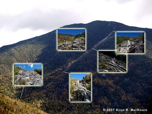
![Blake Slide - Slab ID Photo]() Blake Slide.
Blake Slide.![Nippletop Slide ID Photo]() Nippletop Slide.
Nippletop Slide.![Nippletop Slide - Rubble Field and View Toward Summit]() View up from the rubble field toward the summit proper. Note the secondary slide entering from the right side of the picture.
View up from the rubble field toward the summit proper. Note the secondary slide entering from the right side of the picture.


Comments
Post a Comment