Specifics
Duration: 6:15 a.m. – 1:45 p.m.; 7.5 hours
Summit: Wright: 10:45 a.m.
Route: ADK Loj – Marcy Dam and partway to Avalanche Camp – Cross at 1st island to open bushwhack parallel to Marcy Brook – Follow Wright Drainage to Algonquin slide rubble – Wright Slide to summit – Loj via trail
Total Mileage/Vertical Ascent: 9 miles/2800’ vertical
Trail Conditions: Conditions on bushwhack were dry and ideal; main trail was a flooded mud walk in torrential rains
Other Details: Thick bushwhack land 950 feet/250 vertical feet to slide from drainage; Slide duration of 1300 land feet/650 vertical feet
Temperature: 80’s/cloudy/T-storms.
Partners: Pastor Derek from Lake Placid Baptist Church/Rob
Diet: 1.5 liters water, 2 Deb cakes, 1 MRE Vegetable Quesadilla , 1 Optimum bar
Clothing: Hiking pants, Nylon/shirt, Rain jacket, Golite trail running sneakers, Gregory pack.
Kevin's Account
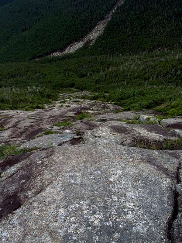
![Wright Slide Top Down View]() Wright Slide
Wright Slide
The Wright Slide hike took on several purposes from its original scouting mission for the 46 Traverse. This actually became the minor goal in lieu of several others. Earlier in the summer, the Pastor at Lake Placid Baptist Church expressed interest in hiking with me. I inferred this to mean that he’d like to experience some off-trail hiking in the Adirondacks : ) I don’t know if I was correct, but the following account summarizes the results! Anyway, I also wanted to find the wreckage and plaque commemorating the crash of a WWII bomber on Wright in 1962; a quest I’d failed at multiple times since 2002. Finally, I wanted to finish what I’d started in 2004 when I ATTEMPTED to climb this slide, but bushwhacked a parallel course instead…by exiting the drainage too soon.
Saturday morning began at 4:45 a.m. In record time, but normal drowsy fashion, I readied water, food and started the short drive to the Loj and to pick up my Pastor (Derek) and his brother in law, Rob. Neither had done any bushwhacking in the ‘Daks and only a couple high peaks each. The three of us were extremely enthused to say the least.
The 2.4-mile walk to Marcy Dam passed quickly and was accompanied by discussions of religion, family, the Adirondack Protection Agency and details regarding the imminent bushwhacking experience beyond the dam. The joke to mileage ratio was high. The clouds, however, were low, foreshadowing the summit experience shared later in the day. An earlier forecast called for showers after noon, hence our early start. Our first break was at the dam, from which Colden loomed in partial obscurity. Low clouds always add a unique feel to a hike. Rain did not appear to be near.
The bushwhack to Wright began when I led us off-path after the first island found in Marcy Brook. This was roughly ten minutes’ walk from the dam. My intended route was to diverge from Marcy Brook following a tributary southwest. A secondary tributary then enters from the west between Wright and Algonquin. The initial tributary actually enters Marcy Brook shortly after the SECOND island, not the first. My mistake increased the length of the walk parallel to the brook, but the way was through loosely knit woodlands, so it didn’t present a problem. Broken branches, scat, hoof prints and a bedding area marked a deer path at regular intervals. We diverged uphill at the first (and seemingly correct) tributary we encountered. Fifteen minutes later, found me second guessing my choice and checking the GPS. I didn’t recognize the topography of the area from my earlier attempt. The hunch paid off as I noticed we were actually following a tributary on the north side of Wright’s ridge rather than one several hundred yards to the south. The situation was easily corrected by skirting the ridge above a small section of cliffs on its east side. We lost little if any elevation during the ten-minute walk.
The mistake also cause us to intersect my SECOND intended drainage which climbed roughly one thousand feet to our next destination. We took frequent, but short breaks along the moderately steep ‘whack through the trees, as I occasionally added warnings to, “Watch your eyes.” As Algonquin closed from the south and the trees began to choke, I led us from the woods into the cascading drainage for a refreshing change of pace. The runoff was very cold and numbed my legs to the knee in several deeper areas. The higher we ascended, the more blow-down we experienced, though it was light overall. I played photographer and snapped pics for remembrance at unique or beautiful areas all the while keeping an eye on the altimeter and natural signs along the way indicating slide action. Slightly above a prominent cascade, we saw damage to the south from the rubble slide on Algonquin. This was about the right altitude to take a perpendicular route into the tight evergreens. Prior to the cascade, I saw the area where I mistakenly exited in 2004 and bushwhacked for two hours through the thick trees up to the ridge.
We plunged up and into the dark wall of conifers…which were blessedly pliable as opposed to those on Redfield, Rocky Peak Ridge and a dozen more areas I thought of off-hand. Broken branches, intermittent tramplings on the earth and drainages led the way upward. Pastor Derek and Rob, however, were in the midst of a new experience. I knew this wouldn’t last for miles or I wouldn’t have taken them, but the ½ hour it took to navigate the 900ish feet to the slide was a good initiation to the backcountry. I stated that Rob should blame Pastor if we got lost, since I kept heading toward the light and he said “going toward the light” was a good thing! Something akin to, “Bushwhack once, shame on you; bushwhack twice, shame on me,” came from Rob’s mouth, though it was somewhat muted by the multiple screens of evergreens. We (and a small armada of mosquitoes commanded by two deer flies) finally took a break in a very small clearing.
Eventually, a small rubble drainage appeared under foot and mere yards later we erupted onto the mossy bottom of Wright’s SW slide. The summit cone shone like a beacon some 700 vertical feet upward. I gave quick directions on climbing the slide such as, “Stay off the wet red moss.” Within seconds Pastor donated a little blood and skin to the mountain as he realized the full meaning of my words. To quote my hiking partner (WalksWIthBlackflies), “One cannot be told of the nature of slippery growth on steep grades, one must experience it.” WWBF and I each experienced the lesson three times a piece on our first hike up Allen’s slide together in 2004.
We ascended casually and enjoyed the partially obscured views to the east and Algonquin’s bulk to the immediate south. Light intermittent winds brushed the mountain and removed the few bugs that joined us. The slide’s grade was between 35-40 degrees with a few brief steep sections, especially near the top. Navigation was easy and Rob/Pastor climbed in a straight line. I navigated small faults for the fun of it and to find various photo vantage points to capture pics of the both the slide and my fellow hikers. Red algae grew at a minimum and was easily avoided, though that wasn’t necessary since the slide was both rough and dry once away from the base. It is a slide that I’d attempt in the rain, if necessary, as opposed to some, such as Blake’s slide that become treacherously slippery when moist.
![Cripple-brush on Wright]() Pastor and Rob swim through the cripple-brush.
Pastor and Rob swim through the cripple-brush.
Satellite imagery showed a vast diagonal shadow caused by a ledge near the top of the slide. The ledge was about six feet in height and is easily scaled at various locations, though most people say the far left is easiest. For some reason, we each chose a different place. I found some little foot holds near the center of it. As I pulled myself over, I took a pause to enjoy the blueberries that literally appeared under my nose before the climb up the steep final section just prior to the cripple brush. The wade through the cripple brush only lasted for about 100 feet, though it was no less annoying than any other time. I exited first which allowed me some amusing pictures of Pastor Derek and Rob “enjoying” their “swim”. A quick climb up the crown found us sitting on the summit under a light summit breeze watching the clouds wisp by at 10:45 a.m. This was the first of five climbs up Wright in which it wasn’t bombarded by break-neck winds.
Ironically, I’ve always found my way through the backcountry, but, in four previous trips up Wright, I was unable to locate the blatantly obvious wreckage of the B46 that crashed into the mountain in 1962. Our search for the pieces began along a path down the north side of the mountain. It descended about 100 feet and led to several pieces of the mangled plane body and followed the ridge east. After a bit of exploration, we called it a day and began the trek back up to our packs. The skies opened as the southern winds pushed the first of the thunderstorms across Wright. My pack was inundated upon arrival. Rob and I quickly donned our raincoats as Pastor Derek slipped into his dark plastic Glad trash bag…head/armholes not included. The jokes continued for quite some time at his expense and his designer attire. He simply said he was…Glad.
I still had it in mind to find the memorial plaque. We trekked from the summit rock to the west, slipped down a stone chute and finally happened upon my last goal above another large chunk of wreckage. I’d accomplished my final mission of the day. Our exit from the summit was as expeditious as the rains safely allowed. Lightning flashed over the nearby Street/Nye range and echoed deeply. I can’t say I was thrilled to be above tree-line in a T-storm, but I was by no means panicked. The 11:00 a.m. storms had arrived a couple hours ahead of what I’d hoped. It was akin to Iroquois’ summit a month earlier minus the sleet and intolerable winds.
The final slog down the maintained path found us passing dozens of people in ascent and several more slowly descending. Occasional breaks gave us mere moments’ respite from the torrent. It truly was a continuous driving rain, which I dramatically likened to a sheet of water with occasional air pockets. The MudRat trail name came to life over miles of muddy trail covered in inches of flowing water. I’d let my blood sugar get slightly low, but committed myself to a steady march while awaiting the appearance of the intersection to Marcy Dam that I knew was only minutes beyond the Whales Tail Ski Trail. The oppressive feeling that the heavy rains cast upon my psyche quickly abated as I ate a Debbie Cake (my wife is Debbie). The last mile to the car passed quickly.
Pastor and Rob did themselves proud during their first hike in the thick of the backcountry and on one of the high peak’s exposed off trail routes. It was a wonderful day. As my wife stated in the following Praise Report, they also didn’t kill, disable or excommunicate me for my assumption in taking them off trail! The following day at the end of church service; Rob, who was running A/V, displayed several pics on the church screen for all to see.
Pastor’s Blog of the Hike, “Hiking with MudRat and Rob”
Also viewable at:
Pastor's Blog with Pics
Last Saturday, my brother-in-law, Rob, and I accepted an invitation to go hiking with our friend, Kevin McKenzie. (Rob had never met Kevin before the day of the hike.) We all three go to church together at LPBC. Kevin wanted to hike Wright Peak, one of the 46 High Peaks in the Adirondack Mountains. Since Rob and I had never climbed Wright Peak, we were excited to go.
One of the things you've got to know about Kevin is that he loves to hike off-the-trail. Bushwhacking is the term used to describe the kind of hiking he enjoys. (I'll describe it below.) Kevin's nickname is "MudRat," and after the hike up Wright Peak and back down, I understand why. [For more on MudRat's hiking adventures - and there are a lot - go to his website www.mackenziefamily.com/46/46r.html. Also go there to see Kevin's perspective and write-up about this hike, along with more photos. You can also see the photo's on Rob's Facebook page -- Rob Lipop.]
A quick summary of the trip. We started at the Adk Loj at about 6:00 AM, and hiked to Marcy Dam. Then we went off the trail, following the river a short distance along a path. Then we crossed the river, and started up the mountain through the brush. The pine trees were a little sticky, but not too bad. When we got tired, we would stop to rest. MudRat was following a deer path, which was evident from time-to-time by the deer tracks and deer droppings. We eventually made our way to a stream that would be our main way up the mountain for a while. We climbed up and over rocks, in and out of the water, around waterfalls, under fallen logs, over fallen logs... it was cool. My wife & kids would have loved this part of the hike.
Then MudRat found our path up to the slide, which is a large slab of exposed rocks that would be the final part of our ascent to the summit. This path up to the slide was tough. Literally. This was the major bushwhacking. No machetes were used, just our shoulders and hands moving the trees out of our way through the thickest-pine-forest-you've-ever-seen. Sometimes the trees were so thick we could not see each other. We would have to call out to see which direction to hike. You couldn't even see your shoes sometimes. One time Rob said, "I am sure we are walking IN the trees." I think he was right. After making it finally through the bushwhack portion, we had a lot of fun climbing the slide. For most of it, we had to be very careful with each step and each handhold. No climbing gear was used, so we had to be extra careful with each step. After ascending the slide, we made it through one more short thicket via bushwhacking then we were at the summit. A good, 4 1/2 hour hike up.
The great things about hiking off trail include: getting to see some parts of God's creation that only a few people get to see; a good variety in the hike (up rivers, up rock slides, through thick forests, not just a normal trail); some great experiences to share with the guys you are hiking with, especially the blood you donate to the mountain.
Anyway, at the summit we ate lunch, then decided to try to find the debris from a WWII plane that crashed on the peak in 1962. After the war, the plane was flown out of Plattsburgh Air Force Base for training missions. Three people had been killed in the crash, and we found some of the debris. My kids and my wife would have loved to see that too.
Kevin had promised us "360 degree panoramic views of the High Peaks" in his email to us inviting us on the hike. Well, that is, those views exist unless the storm clouds begin rolling in. And did they roll in. Quickly. We were still looking at the debris when it started raining. Hard. We scampered back up to the summit, grabbed our backpacks, and put on our rain gear. I had made a crucial decision before I left the house to NOT bring my raincoat, but I had thrown in a trashbag to make an emergency poncho. Well, I needed it. I poked holes for my head and my arms and put on my backpack, then pulled the Glad trashbag over me. That led to a lot of jokes (mostly at my expense), but that was OK. It was pretty funny. And it was keeping my core dry.
We descended down the "people trail," the regular trail for Wright Peak. Lightning flashed and thunder cracked right beside us. MudRat wasn't sure it was a good idea to be above the tree line, so close to lightning that could electricute us. Kevin joked, "It would be bad for tomorrow's headlines to read: 'Three people struck by lightning at the summit of Wright Peak, and one of them was the Baptist minister!'" We knew God would protect us, and we knew He wanted us to descend as quickly as possible. We saw a lot of people coming up the mountain, who kept asking us, "How much farther to the peak?" and "Is it going to rain all day?" [They also kept laughing at my trash bag.] The descent was 3 hours, and it poured the entire hike down. Every time the rain let up a little, a couple of minutes later it was pouring. We were soaked from head to toe. Except for my core, which was covered by a trashbag. MudRat sloshed through every mud puddle he could find (hence his nickname), and we finally made it back to his car. What a great day.
So, we give thanks to God for the amazing mountains He has created. We thank God for the rain He sends to water the earth. We thank God for the strength to make hikes. We thank God for His protection. We thank God for friends to hike with. We give thanks for all things.
Deb's Praise Report
Good Morning All,
I have THREE praise reports!
1. Rev. Spain and his brother in law, Rob, SUCCESSFULLY completed the first phase of the 'MudRat Challenge' ...AKA hiking with Kevin MacKenzie. Neither suffered head trauma, broken limbs or loss of life.
2. Kevin MacKenzie, I am happy to report, is ALSO alive. Neither Rev. Spain nor Rob chose to KILL him (or throw him back down the slide) for taking them thru such brutal terrain....in pouring rain that was equivalent to the rain that fell during the Ironman competition.
3. The Final praise report (leaving the best for last)
Though lightning began striking while the three hikers were on the summit of Wright, GOD chose to spare all three lives. None of them were struck by lightning. MudRat was quoted as saying 'It just wouldn't look good if the headlines read: Three hikers STRUCK by lightning on summit of Wright...one being the Minister of LPBC'!!”
NOW, for the request to the church family. It appears Rev. Spain needs a raise, as he was not properly geared for the torrential rains. He came equipped with a Large GLAD trash bag. He was quoted as saying 'He was GLAD to have it!' As a church family, we should hold a special offering at this mornings’ service. Hopefully we can pull together and make it possible for him to have proper gear for the next phase of The MudRat Challenge...or at LEAST a construction grade garbage bag!!
God Bless,
Deb MacKenzie
Additional Pics of the Plane Wreckage
![Plane Wreckage Collage]() WWII Plane Wreckage Collage
WWII Plane Wreckage Collage


Comments
Post a Comment