Specifics
Duration: 8:55 hours; 7:15:40 am – 4:10 pm
Summits: Giant, 1:00 pm
Route: Roaring Brook Trail to 2600’ to Bottle Slide, down Diagonal slide, up Question Mark Slide to summit, down tulip and back to main trail at 2600’.
Total Mileage/Vertical Ascent: 6.5/4000’
Trail Conditions: Dry trail conditions. Primarily dry slab conditions on Bottle and Tulip. Slippery on Diagonal and Question Mark due to seepage.
Temperature: High 40’s - 70’s
Partner: None…solo hike
Diet: 3 eggs, ½ loaf banana bread, 3 powerbars, 1 gallon water.
Clothing: Torn hiking pants over tights, light shirt, hat, sunglasses.
Pack Weight: 25 lbs.
Pictures: Detailed Pics of Each Slide
While trip reports for this year have been non-existent until now, hikes have not. WWBF and I hiked Giant in the rain a couple weeks ago…the wet weather took climbing Giant’s East Face out of minds. We also explored some smaller mountains: Ebenezer, Baxter and Winch. This was my first slide since Grace this past winter. I hoped it to be a stress-relieving day as well. I wasn’t disappointed.
The forecast called for near perfect conditions, so I set my mind in motion, shooting ambitiously. I’ve been on the Eagle a couple times, so an exploration on either side seemed appropriate. The plan included the west face slides of the Bottle (west), the Diagonal (southwest) (on the opposite side of the same ridge), the Question Mark (west) (adjacent, but South of the Diagonal) and the Tulip that descends northwest from the ridge trail.
I got to the trailhead and started a slow walk at 7:15 a.m. Temperatures were in the fifties…perfect. I began the bushwhack portion at about 2600’. A monstrous black birch awaited in the drainage. I estimated its width at between 40” and 48”.
Hitting the Bottle
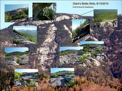
![Giant Mtn. Bottle Slide ID Pic]() ID Pic of Giant's Bottle Slide
ID Pic of Giant's Bottle Slide
The location of the Bottle Slide was no big mystery…I’d been over it many a time in my mind’s eye and knew the area well. It’s base was located at the end of the northernmost drainage that travels the farthest east. I decided to explore a bit on the way. I bushwhacked from the base of Roaring Brook Falls my first time on the Eagle. I split from the trail as the path began a more earnest ascent while the brook was still in earshot the second time. This day, I decided to walk a bit higher until the stream could no longer be heard. The woods were easy as expected and I came to the drainage near a monster black birch after about five minutes’ walk.
A half-mile or so later I came to the divergence for the Eagle or Bottle track. The drainage was as expected…set in a mild gorge, its steeply sloping sides occasionally broken by intersecting minor slides. I made a carefully unplanned trek into the southernwoods to get away from the blow-down and followed a deer path. Fresh hoof-prints led the way a half hour or more. The soft ground was better than slippery rocks. I didn’t want to risk another chipped elbow…something I got from the Eagle’s bite several years ago. A quick traverse across a side slide…solely rubble and sand gave me pause. I looked up at the ten-foot wall of overhanging boulders and soil. I’d be in trouble if something triggered it to let loose. The small pioneer growth, however, gave me some comfort in that it hadn’t moved in a few years, at least.
A few minutes later, I veered north and met the drainage slabs leading to the rubble base of the Bottle. I arrived at 9:30 a.m., close to my estimate under the cool morning air delightfully free of blackflies and midges. I took time to eat a powerbar and soak in the view on the north ridge…a gathering of smooth sun glistening lesser slides that meet the Bottle’s drainage perpendicularly from the north ridge. I’d no real interest in climbing their wet slippery slopes. The blackflies weren’t awake as I prepped my pack on the rubble field at its base.
I couldn’t yet see the main slabs. Pioneer trees blocked the way, but a five-minute walk put me upon the opening slabs.
The beginning of the Bottle surpassed my expectations and promised an interesting climb. It was about a 39-degree average ascent. I really don’t know what I expected, but I was impressed with what I saw…tier after tier of feature laden slab culminating at the final cliff wall far ahead. The surface of the rock, cracks, dikes etc. all created the perfect slide…steep with traction. The steeper sections were more like giant anorthositic swells in a sea of ascending stone. Each swell had smaller shelves that made for an easy ascent. Between each swell was unadulterated slab, not smooth, but not rugged either. Small patches of vegetation poke through every now and again. I found bare rock whenever I needed it. Only intermittent moss and occasional lichen dotted the anorthosite. My feet didn’t slip and I quickly felt at ease…no need for the climbing shoes in my pack. The greatest challenge was not in the climb, but in its photography. The sun was only slightly above the summit and the slide rose just shy of into the sun. I had no lens shield so my hand had to serve to eliminate the lens glare.
With elevation, the shelving became more detailed and defined. Dix and the Great Range beckoned from a distance, their forms set in a mild haze. A small rubble zone broke the sea of slab about halfway up to the headwall. Higher up, a particularly interesting section lay on top of a shelf. Layers of anorthosite frequently become hollow underneath from nature’s actions. A gentle rap on the correct area of a seemingly solid slab will prove the point. One of these layers had been worn further until it formed an arch of stone through which, one could peer and see the summit above. The grade increased slightly before a short span of trees stopped at the cliff.
It was about 10:30 a.m. and I’d climbed about 3100’. I’d no intention of climbing the cliff since I’d summit the mountain after the Question Mark slide, though I did trek up to its base to explore left and right. Several promising crag climbs looked inviting. I couldn’t resist ducking under the hollow leading edge of the cliff, its edge dripping seepage. I enjoyed the cool air and view afar before venturing out to the second leg of the day.
Descending the Diagonal Slide
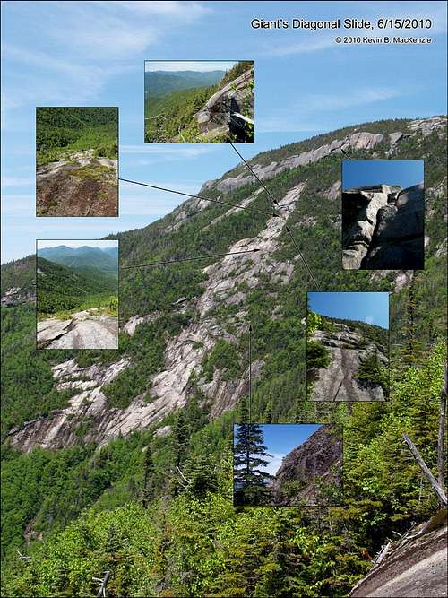
![Giant Mtn. Diagonal Slide ID Pic]() ID Pic of Giant's Diagonal Slide
ID Pic of Giant's Diagonal Slide
The top of the Bottle and Top of the Diagonal slide come very close to meeting just below the cliff. I hugged the wall as I squeezed between the trees, tight for even me. At some point I decided to head down and look for the stone. Gravity aided my push through the cripplebrush until I popped out at the top of a ledge…not the primary slide just south. Below, the stone was wet and mossy, but I could see the Diagonal slide just a hundred feet north. I cross traversed and discovered a new breed of cripplebrush: limbs from one tree had grown near the trunk of another and, some time long ago, fused creating a living fence. I found a way through…
The Diagonal was steeper than the Bottle and descending is trickier than climbing, one can’t see what’s below in some instances. The contours of the Diagonal were quite convex in places and less stepped overall, so as I descended, the rock slope increased out of site until meeting the next slab. To make matters worse, it was wet and had more algae/moss than stone in some areas. I kept a conservative approach (being solo) and stayed near the edges to navigate the many ledge drop-offs and put slab under my feet when the conditions permitted. Several descents were actually slides of several mossy meters. I carefully made sure a large tree grew below to stop me. I quickly became soaked, but the temperature was now in the high sixties. I was comfortable and so was the horde of blackflies.
On a side note, I purposely wore old hiking pants. They had holes meticulously patched with duct tape…except the hole on my rear. Fine…I was wearing tights (which help with friction) to maintain my modesty. I just didn’t plan to tear such holes in the tights as well. I’d be on the summit in the near future after the third slide and anyone trailing behind me would see my MudRat mud flaps! Oh well, everyone’s got a rear. Back to the slide…
About 2/3 of the way down, I stopped for lunch. The slab was dryer below and grew even steeper. I didn’t plan to trek its entire length since the beginning of the Question Mark slide was now only a few hundred feet south and I wanted a direct route over to its beginning. I veered south about one hundred feet from the bottom of the Diagonal. The lateral climb was a combination of slippery slab and cripplebrush, but only lasted minutes. It was foreshadowing to what was next.
Ascending the Question Mark Slide
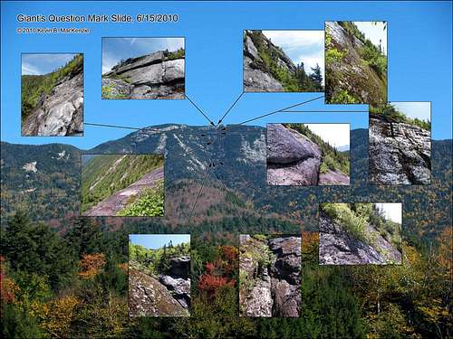
![Giant Mtn. Question Mark Slide ID Pic]() ID Pic of Giant's Question Mark Slide
ID Pic of Giant's Question Mark Slide
A meager trickle of water flowed down the crack of the drainage: a perpendicular fracture zone. It was an interesting feature, bordered by slimy slab to the north and a ten-foot ledge to the south…where I wanted to be. I climbed the crack and pulled my way up using mossy footholds and young trees as a lifeline. Some minor slab: wet, red and mossy greeted me. I groaned, but it was what I expected.
For future reference, I should have gone straight up, but decided to go up and south…bad idea. I still found a few open areas, but not what I remembered from pictures. There should be hundred foot lengths of slab not constant trees. Surprisingly, the tight conifers opened to mossy ground dotted with loosely woven trees…open forest by my standards! I made the stupid decision that I MUST be too far north and spent another ten minutes tiring myself until I saw open area ahead. Something felt wrong and I consulted my camera pics from the Diagonal slide. NO, I was too far to the south actually. I’d nearly bushwhacked to the Eagle Slide. So, back the other way I pushed and groaned until I found my beloved slab once again…if wet, mossy, slippery slab at greater than 45 degrees can be called “beloved”.
I’d been wading around the trees for about an hour before finding the real slab, not climbable in its current condition and by my standards. A few cracks let me climb portions as I explored one particularly steep area. So, using the moss and trees to climb, I made my way to the quickly approaching summit. I huffed my way up a ledge and onto my stomach in the cripplebrush to find an old plastic bottle. In the pack it went…might as well clean as long as I’m here. It also proved there’s been more than one “fool” in the area over the years.
The final climb really was a cliff, just not quite vertical. It provided plenty of layers and cracks to climb, however. Finding the right way took another few minutes and I finally broke onto the summit at 1:00 p.m. after one and one half hours of bushwhacking and over 700’ of vertical gain. I realized that it lived up to its namesake “The Question Mark” in several ways: I kept asking myself, “Where the heck is it?” “Why am I here?” and “Can this really be a slide?” The answers are respectively as follows: Nearer to the drainage, because I’m a curious idiot, and Barely.
Descending the Tulip Slide
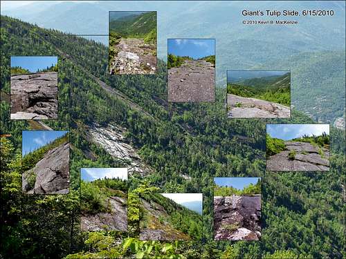
![Giant Mtn. Tulip Slide ID Pic]() ID Pic of Giant's Tulip Slide
ID Pic of Giant's Tulip Slide
The Tulip nearly intersects the ridge trail a bit prior to the intersection of Roaring Brook trail. Two minutes walk through the brush puts the climber on the sandy/rubble upper slab. Some years ago, I explored the top and found it slippery and red in the water. It was dry underfoot this day. Upon descent, I found myself comparing its features with Colden’s SE 90 Slide except without the sharp rough anorthosite crystals. It was a challenging descent, but comfortable in that the rock offered both plenty of traction, cracks and other features.
The straight slab seemed to descend forever or for a total of about 600 feet (take your pick). The ridgeline of trees eventually disappeared behind the pathway of stone.
Several steeper portions accompanied the descent. The character of the slab was similar throughout the descent until the footwall. It then became steep and more rounded with vegetation. I navigated the eastern series of wet cracks and vegetation and took care with my footing. This marked a distinct turn in the slide as it took a more westerly path at about 3600’. A small bowl with reverse ledges marked the area.
As it descended, the walls became steeper in the typical fashion of drainages in this area. The western wall boasted other intersecting slides, but they didn’t hold my attention, as footing was my main concern. I was getting tired and the footing was getting more precarious due to the large amount of rotten blowdown. I was forced to spread my weight more than once to ensure I didn’t fall through. The terrain continued to be very steep amidst the other issues. Finally, it began to level and the blow-down/rubble lessened. I intersected Roaring Brook at 3:00 p.m. and bushwhacked back to the trail…content with the day and with energy to spare.
I needed this day to cleanse a bit of stress from my psyche, to push myself, yet not too much to make it tedious. It worked well. I was relaxed as I returned to my truck at 4:10, a little less than nine hours from the day’s beginning.


Comments
Post a Comment