Specifics:
Dates: May 22-24, 2009
Partners: MudRat & WalksWithBlackflies
Temperature: 40’s - 70’s
Trail Conditions: Trail wet with mild runoff; Woods dry
Total Mileage/Vertical Ascent/Duration: 32 miles/8000 ft vertical/27 hours
Day 1: 4.9 miles/1500'/2.5 hours
Day 2: 14 miles/5000'/17.5 hours
Day 3: 13 miles/1850'/7 hours
Day 2 Summits: Couchsachraga: 8:37 am; West Couchie Ridge Knob: 10:00 am; Emmons 6:00 pm; Donaldson: 7:00 pm; Seward 8:00 pm
Day 2 Route: Panther Brook Camp – Couchsachraga (2.7 miles/+1678 vertical) - Cold River (+2.2 miles/-2060 feet) – Ouluska Leanto (+1.1 miles) – Emmons via Emmons Slide (+1.3 to slide drainage, +.8 slide bottom, +.3 summit & +2170 vertical) – Donaldson (+1 mile) – Seward (+.9 mile) – Truck Trail ( +2.25 miles/-2300 vertical) - Camp 4 Leanto (+1.5 miles/+270 vert.)
Slide: Emmons Slide is a bit over 1000 feet in length and between 400-500 vertical feet
Day 2 Diet:
MudRat: scrambled eggs/bacon with protein powder, macaroni & cheese, energy bar, chicken primavera, nuts, 2 energy bars at 11:30 pm; 5 liters water;
WWBF: 1.5 cup cereal, 1 cup milk, 1 serving trail mix... 1 granola bar and 1 serving cashew chicken merely rented for a limited time.
Clothing:
Mud Rat: Columbia long sleeve titanium shirt, EMS rain jacket, REI rain pants, Golite Trail Fly sneakers
WWBF: Techwick short-sleeve shirt, EMS wind pants, Wright socks, Merrill trail shoes
Pack Weight:
MudRat: 35-38 lbs.
WWBF: 32 lbs with full food/water
Day 1: Friday Night Hike to Panther Brook Camp
MudRat's Account:
Our hike began at 6:50 p.m. at the Santononi trailhead. The largest conversation piece was over the herd path to Santononi Mtn. since neither of us had taken the “new” old path yet. We found it just before the marshiest section of the trail about ½ mile before Bradley Pond where the path veers to the right (going toward Bradley). Our goal wasn’t to climb it, just to note the location. At 8:35 p.m., we arrived at Bradley Pond, but kept walking another ½ hour toward a campsite adjacent to the cliffs that dominate the area near Panther Brook. The sun was, but a memory, as we began to set up our tarps.
I did a much cleaner job of setting up the tarp than my attempt two weeks prior. I also brought a sleeping bag and down camping booties to help with the chilly nights. My set up worked well and my feet did not get numb this time. The evening’s highlight began as WWBF said, “Get off my foot,” to a kangaroo mouse. It walked a few inches away and proceeded to checkout all our equipment, but most especially WWBF’s dinner. It also favored his spoon which I noticed it laying inside of. Other interests included WWBF’s Mouse Vault, I mean bear vault which worked well against the tireless beast we’d, by now, named Pixie. He blamed pixies for stealing his spoon a couple years ago near Cliff Slide. After an hour, it became annoying, primarily since we didn’t want it in our sleeping bags once we settled in. We’d stomp on the ground and it would jump (several feet at a time) out of site only to return minutes later. Finally, after playing “scoot the mouse” for a while, we retired. The night was uneventful other than the sound of “skitter, skitter, skitter” and the flick of a sleeping bag as WWBF attempted to deter Pixie from running up and down his body on the bivy sack. For some reason it really loved WWBF and jumped on my knee only once. The bear vaults worked well against the mouse : )
WWBF's Account:
I showed up at the trailhead about 10 minutes before MudRat, and was immediately greeted by swarming blackflies. I was breaking out the repellent just as MudRat showed up. After a few minutes of last minute packing, we were hiking on the dirt road towards the Bradley Pond trail.
The hike in was relatively uneventful. As MudRat previously mentioned, we were able to locate the "old-new" herdpath but continuted onto Bradley Pond. The trail, which is typically one of the wettest in the High Peaks, was amazingly dry... or should I say "merely moist".
I had remembered passing a nice-looking camping area near Pather Brook on my previous three times on the herdpath to/from Panther Peak. What I did not remember was the very steep ascent to the camping area. We briefly lost the path at one area of blowdown, but overall it was easy to follow. The expansive towering cliffs to our right helped keep boredom to a minimum.
After tarps were set, I ate the Pad Thai meal that I had prepared. This apparently smelled good to an overly-friendly kangaroo mouse. At one point, MudRat noticed that the mouse had knocked-down my spoon from the top of my bear canister, and was sitting in it. Thereafter, we refered to the mouse as Pixie, after our previous experiences with missing spoons on Cliff Mountain. Pixie was so "friendly" that I had to close the cover of my bivy sack to prevent her from running into my sleeping bag. Thankfully, half an hour after lying down, Pixie got bored of us and I was finally able to fall asleep.
Day 2 Morning: Couchsachraga to Cold River
[img:516352:alignleft:small:View of the Sewards and the bushwhack from
Couchi to Emmons via Cold River.]
MudRat's Account:
Saturday morning began early and we were on the trail at 6:00 a.m. After a quick water stop, the trek up Panther Brook to Times Square intersection went quickly and without pause. A few spots of snow and ice reminded me of Redfield, but disappeared quickly, much to our relief. The way was dry in comparison to any other trip we’d taken in the Santononis. Breakfast consisted of re-hydrated scrambled eggs, bacon and protein powder, which I ate at 7:00 a.m.
Seven-fifteen a.m. began our descent to the much maligned Couchsachraga. The mileage passed easily and quickly until the ridge view over to the Sewards, our goal of the day. The sea of green looked like an easy crossing from a distance…deceptively easy. We reminisced about the last time we were on “Couchie” back in 2004 when I achieved my 46th peak. Our summit time this year was 8:37 a.m. when we ate “Second Breakfast.” The total mileage from our camp (in cedars above Bradley Pond) to Couchsachraga was about 2.7 miles and 1678 vertical feet.
![Couchsachraga Whack]() Typical woods on Couchi's west side.
Typical woods on Couchi's west side.
The normal route off Couchsachraga is almost always a roundabout up the same ridge. Several other routes were in our mind including north to one of several tributaries or even back down the trail to a tributary off the north face. We settled on a heading northwest and jumped into the cripplebrush near the summit rock where it looked “open” (meaning we could almost get our shoulder through the trees). The way became even more open nearly immediately and sloped downward at a comfortable grade. Our first obstacle was a small cliff which we easily circumvented. I’m amazed to say that we encountered only mild blow-down and a relatively easy passage that allowed us to take in our surroundings such as mosses that draped lazily on glacial erratics and a massive exposed root structure where WWBF posed for photos. We also tested the area for sod holes. The result was positive. I scored the first, but WWBF outdid me in quantity.
![Cliffs on West Couchsachraga]() Cliffs on West Couchi.
Cliffs on West Couchi.
Cliffs on the knob of the west ridge was our visual target while descending Couchie’s flank. The visual helped since we traveled at a diagonal, both down and across. This orientation almost always throws me off since I feel like I’m traveling too far to the left no matter my actual direction. I eyed the way through the trees and light blow-down as WWBF corrected the heading occasionally until we reached the fault-line…a fault-line about 20 feet in diameter and incredibly free of debris.
![MudRat Climbing Cliffs on West Couchsachraga]() MudRat climbing the cliffs.
MudRat climbing the cliffs.Callahan Brook began somewhere not far to the southwest in the fault-line. I exclaimed, “It’s your fault!” as a bad pun. The next section was a bit tight (to say the least), but the climb was only a ten minute push through the dense spruce until we found the base of the cliffs. Several feet of clear soft moss carpeted the boundary between the open cliffs (about fifty feet high) and the dense growth on the ridge. “How often will we have the opportunity to summit this area?” we asked ourselves and proceeded to climb the cliff face to rest in the moss and small trees on top. Pink lady slippers were just beginning to bud and the blueberry bushes were in bloom. It was 10:00 a.m.
![Couchi from West Couchsachraga]() Couchsachraga from summit knob on west ridge.
Couchsachraga from summit knob on west ridge.My primary goal on the top was to take pics of Couchie from a less than common perspective. I kept my rain jacket on to protect against the cool breeze that blew up the cliff in mild gusts. The distant sky looked ominous, but not threatening. Forty five minutes later found us descending another area of the cliff and on our way to the ridge’s drainage. The forest was tighter than on Couchie and our easiest travel was outside the drainage which consisted sphagnum moss over small boulders amidst blow-down and tight fir undergrowth. It was steep but not overly until we reached the hardwoods where we were able to follow next to the drainage more closely and easily. The clear water called to me to refill my water bladder. The blackflies were happy for our break and found a spot free of bug spray in the corner of my eye. I was feeling good and the route was incredibly easy compared to what my mind had been conjuring for more than two years.
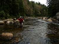
![Cold River Crossing]() Crossing the Cold River.
Crossing the Cold River.A few minutes hike later we came up the horse trail from Northville Placid Trail. It was about a car’s width wide and disappeared from site in the growth as we trekked to the south side of a small pond located at 44 deg. 6’ 35. 81 N / 74 deg 11’ 07.07 W. It was peaceful and quiet as we walked on the thick carpet of moss to a deer path that led us to the pond’s drainage. One half hour later found us at the picturesque Cold River.
The Cold River captured my fancy. I immediately thought of my father and his desire to find new spots to fly-fish. As a comparison, this river is slightly larger than the Ausable River (West Branch) and obviously delivers a heavy flow at certain times of the year. The sun blessed as we crossed at the confluence of the pond’s stream and the Cold River in refreshing knee deep water. WWBF got a laugh as I carefully drained each shoe for several minutes on a rock on the other side and immediately fell back in. I heard my wife’s voice in my mind saying, “Nice move Gracie!”
The river’s flow changed in various areas as it choked or expanded into calm sections. We'd found the perfect area, at least under present conditions.
The Northville Placid Trail was only yards on the other side of the river. A walk of just over a mile found us at a wide calm area where Seward Brook entered from the north (left). Conveniently, Ouluska Leanto was set there as well and we took a break at 1:00 p.m. We marveled that the bushwhack from Couchsachraga’s summit only took four hours (actually a bit over three since we spent forty-five minutes playing on the West Couchie cliffs). I sent a checkin on the SPOT unit and ate the remainder of my lunch and an energy bar while refilling our water bladders for the next major quest of the day.
WWBF's Account:
{Burp}{Burrrrp}
Ten steps into the day's hike and I was burping up last night's dinner. "That's not a good sign", I exclaimed.
Two minutes into the hike we reached Panther Brook, filled our water bottles, and began the steep ascent to Times Square near the summit of Panther Mountain. MudRat ascended at a near perfect pace. Although my stomach was trembling, I thought that breakfast at Times Square would settle it.
An hour after our start, we reached Times Square and I ate my cereal and milk (reconstituted Nido)... and it did seem to settle my stomach. After joking about how the entire site was underwater the last time we were here, we were on our way to Couchsacraga.
To say I was a little nervous about the bushwhack down Couchie would be an understatement. Afterall, "Couchsacraga" in Algonquin means "dismal wilderness", and this mountain has a bit of a reputation. In reality, the hike to Couchie was surprisingly uneventful, although we did get our feet wet while crossing the bog. On the way up Couchie, my spirits rose when I noticed the relative openess of the woods, and I was hopeful that the upcoming bushwhack wouldn't be so bad afterall.
After getting a quick bite to eat on the summit, and discussing the best route down, we proceeded down the western ridge. Although the descent to the western faultline wasn't particularly easy, it seemed so due to our preconceived notions of what the bushwhack would entail. MudRat lead a near-perfect route to the fault, and then up to the base of the knob above the fault. A quick scramble up some bare rock and we were on top of the knob.
After some difficulty getting off the knob, we proceeded down the ridge in a northwesterly direction. We soon realized that staying in the drainage areas meant contending with sod holes, so we angled up to higher ground. The forest was thick with small spruce, and the rough bark of their branches scraped at my bare arms. Also at this time, the blackflies made their presense known, and we donned some repellent while MudRat gathered some water.
At the bottom of the ridge we were greeted with a nice hardwood forest. MudRat again led a near-perfect route to our next landmark, and we made good time through the open forest. We reached the Cold River at a ford-able point, so we just marched across the knee-deep waters to the Northville-Placid Trail on the other side. The easy walk to Ouluska Lean-To gave me plenty of time to realize that we were only halfway done with our bushwhacking for the day, and I was worried about what we still had to ascend.
Day 2 Afternoon: Cold River to Camp 4 via Seward Range
MudRat's Account:
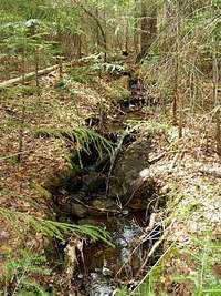
A bridge crossed Seward Brook and a faint herdpath led up the south bank for a few hundred yards before disappearing into the forest. WWBF chose the rock-hop method. I chose the forest ‘whack. It was a good choice on WWBF’s part since it gave him a chance to rescue a bat from the stream. The next 1.3 miles was a trek on a heading that put the sun just over my left shoulder (about 340 true). Directly following Seward Brook would wind us through extra mileage while the forest bushwhack was amazingly clear and easy. The grade was constant through a primarily beach forest spotted with an occasional ancient maple or birch. Several drainage streams increased the overall elevation gain since we had to descent to the drainage and re-ascent to gain the lost footage. My first food “bonk” was at around 2:30 p.m. and an energy bar with some trail mix helped me reach the drainage from Emmons Slide. Our ascent had really only just begun, however.
![Emmons Slide Drainage]() Emmons Slide drainage.
Emmons Slide drainage.
The slide stream was small, really only a foot or so wide where we found it at about 2400 in elevation. Hiking close to the stream was difficult and choked with conifers. We made that mistake on more than one occasion as the forest transitioned from open hardwood to the normal conifers that grow closely together and intertwine their branches like wooden spider webs. As expected, the higher we hiked, the more difficult the pushing became until it was what I’d consider extremely tight as we approached the slide bottom. Intermingled blow-down was moderate, but crippling as we both had energy issues and wanted the open air on our faces. Eventually, boulders began to litter the still small stream which made the passage even more difficult. We were both frustrated and tired.
Finally, after an eternity (actually 4:30) of pushing inch by inch we came upon the slide base, dropped packs and had a snack. I took pics of the Santononis, Seward Slide and Emmons Slide. It is a modest slide that climbs about 500 feet vertically over 1000 ground feet. Its main features are a couple sets of ledges, some eroding slab and lots of rubble. A ledge on the south side was my favorite feature: slab worn convex which then disappeared into the trees. The slide top is a near vertical cliff. I immediately wondered how we’d exit the slide, but others had done, so we would find a way.
After our little respite, we began the short trudge to the top as I took pics now and again. Many slides have tricky areas that require care. This was very straight forward…climb and try not to stumble amidst the rubble. Once at the base of the headwall we located the exit to the right though we noted two other more precipitous possibilities: a diagonal route from the left and a steep diagonal with small trees situated on the right.
The dive into the brush was the beginning of a bit less than an hour of bushwhacking up a slope that I’d liken to Mt. Armstrong’s eastern side. It wasn’t vertical, but the first hundred feet were around seventy degrees. Foot and handholds were moss covered and root littered. Any trace of a mildly defined herdpath disappeared after a few minutes. I assume we zigged when we should have zagged, so the bushwhack began anew up the remaining 400 vertical feet over about 1/3 mile. We ended the ‘whack exactly at the summit at 6:00 p.m, twelve hours after our start from Panther Brook. We only had Mt. Donaldson and Seward to climb, descend and a leanto to find on the truck trail so far away.
![Emmons Slide ID Pic]() Emmons Slide.
Emmons Slide.
Donaldson was about one mile away and took us a bit less than an hour to summit. I was beginning to feel the day, but still comfortable. The mud bogs on top of Donaldson were only mildly wet, but easily navigable as opposed to 2004 when it ate my leg to my knee. We didn’t linger on Donaldson and descended quickly on our way to Seward, only a bit less than a mile away, but another 500 feet of climbing the rocky steep path. The light began to fail just prior to touching the summit which gave me the opportunity to shoot a sunset picture before the rain came…a quick drizzle as opposed to downpour just two weeks prior. Interestingly, I found a plastic geocache in the cripplebrush just west of the summit. Within the plastic box was a stuffed green frog or dinosaur and some papers.
We began our descent in the failing light and tried to hurry over the first section of the two-mile descent of over 2000 vertical feet. The top portion is primarily steep wet slabs and boulder hopping. Occasional roots and mud are thrown in for good measure along the eroded rut/slide that is the trail. Darkness was soon our companion along with the constant flow of water so increased care was taken. Finally at around 8:45, we took out headlamps in order to find the trail that continually routed around precipitous sections and across various streams.
WWBF and I hiked Seymour, Seward, Donaldson and Emmons as a day-hike from the Corey’s area in 2004. Seward nearly took all my energy that day. The trail sucked my energy this day as well even in descent. The mud and water seemed to last forever in the darkness as we went down and down. Our goal was to reach the truck trail that the herdpath intersects and finally a leanto. I questioned at least once whether we’d somehow missed the truck trail, but the herdpath ends at that point. Finally, we came to a cairn and I breathed a sign of relief. I was very tired and hungry. Relief disappeared when I realized it simply marked a brook crossing. On the positive side, we did play with two crayfish in the stream. I tried a pic but couldn’t get a good shot. Again we slogged downward for another ½ hour before it leveled and finally came out on the truck trail and nearby bridge.
We collapsed on our packs in the middle of the trail. I briefly nodded off giving a mosquito ample time to draw a blood sample from my eyelid. This added to my collection of five blackfly bites, to which, I’m thankfully not allergic. After awakening, I refilled our bladders and WWBF sought the leanto, but didn’t find it nearby. We then began the trek toward the next located about ½ mile to the southeast. Bad luck was on our backs; it was occupied and we didn’t want to awake the occupants. We continued to Camp 4 leantos where a blazing fire was going and five kind gentlemen were enjoying the fresh air. They’d taken both leantos, but quickly offered to vacate one for us. (Thank you very much if you’re reading this, we REALLY appreciated your hospitality!…and WWBF appreciated the candy.) It was 11:30 and we’d put in about 17 ½ hours of hiking, about five of which was off-trail. I quickly collapsed into a surreal hiking coma once inside my bivy and sleeping bag.
WWBF's Account:
The lean-to was bug-free, and after a 2+ mile bushwhack, I contemplated calling an end to the day and lounging by the Cold River. However, it was only 1:00... too much time left in the day to seriously entertain such an idea. After a quick lunch and a refilling of water bottles, we headed up Ouluska Brook... I in the water and MudRat in the woods. I soon joined MudRat after realizing that the brook rocks were quite greasy.
The next mile or so was beautiful open hardwood forest. At one point, MudRat and I decided to angle up the ridge toward the bottom of the slide, rather than following brooks the entire way. At about 2:30, MudRat began bonking, so we took an extended rest on a well-placed log. We each had a passing thought that the peaked ridge that lay before us in plain view was the summit, but we both knew better.
Upon resuming our ascent, we left the hardwoods and entered a relatively open fir forest. {Burp}{Burrrrp} Things began getting tighter as we asecended, and there was more blowdown as well. {Burp}{Burrrrp} I was expecting to see a significant drainage coming down from the slide, but there was nothing but little braided streams. {Burp}{Burrrrp} Route finding {Burp}{Burrrrp} became difficult. I kept telling MudRat {Burp}{Burrrrp} to {Burp}{Burrrrp} angle right... then left {Burp}{Burrrrp}... then right again.
I was starting to bonk, and I couldn't tell if the terrain or my upset stomach was more annoying. Then my stomach played its trump card, and I hurled. In Chuck Norris-like fashion, I proceeded without drawing attention to that minor inconvenience. However, about every 10-20 steps I'd dry-heave, and my energy level fell to zero.
After some more route-finding difficulty, we finally found the slide. I hurled once more before setting foot on it. My body desperately wanted some fuel, but my stomach turned at the mere thought of food. With absolutely no energy, I ascended the slide, far behind MudRat who was scoping out the route ahead. The 400-foot slide looked like Everest to me, and I knew that there was a 200-foot bushwhack above the slide. I was not a happy camper.
I finally made it to the base of the cliffy headwall, and MudRat lead a route along its base. At one point, I thought the route lead right, but MudRat assured me it went left. I was too tired to argue. After a struggle up a ledge, I was sure we were on the wrong route. However, MudRat redeemed himself when he topped out directly on the summit rock.
I could barely stomach water, but I forced myself to eat a small bite of granola bar knowing that I had an extended downhill in front of me followed by a minor ascent up Donaldson. Although I knew MudRat wanted to continue over Seward to a lean-to along the Ward Brook Truck Trail, I had secretly determined that I'd descend off Donaldson and find a camping spot along Calkins Brook, and let my aching stomach rest. However, once atop Donaldson, my testosterone wouldn't allow me to take the easy way out, and I agreed to commit to going over Seward.
The herdpath to Seward did not take the route I had expected. I thought it was a ridge walk, but in reality it headed over a minor knob, descended into a valley, and attacked the summit directly. Although it was a steep climb, I was able to pace myself and I performed better than expected. My stomach began feeling very acidic, and I realized that I hadn't brought any Tums. For the past year, I brought a few with me just in case, and I never needed them. But the day before this hike, I noticed that they were looking pretty rough, and I threw them away, intending to bring some fresh ones with me. I forgot to bring the fresh ones. Sigh.
After a bit of route finding difficulty on the summit, we began the rough steep descent down. Being 8:00 pm, I hoped that we'd be off the worst section before dark, and we were. At 9:00, we stopped for a brief rest and I noticed I clear cell phone signal. So we called our wives to tell them that we were basically off the mountain and would be in a lean-to in about an hour.
The next 1.5 hours were the longest of my life. The trail just wouldn't end. I kept expecting the road to appear around the next bend. Finally I was right, after about 500 bends. MudRat and I just lay in the road, not saying a word. I knew that I either had to move or I'd fall asleep, so I volunteered to look for the Blueberry lean-to while MudRat refilled our water. After 5 minutes of hiking I didn't see the lean-to, so I turned around and met MudRat at the stream. (I now realize that instead of staying on the road, I had to turn onto the Blueberry hiking trail to reach the lean-to). I assured MudRat that there were more lean-tos in the opposite direction, and although they were located farther away than the Blueberry lean-to, they were in the direction of tomorrow's travel.
Strangely, I was feeling relatively good... except for the acid reflux. Walking on the flat road, I felt like I could hike the 4 miles to Duck Hole if need be. Need almost be since the Ward Brook, then the Camp 4 lean-tos were occupied. Thankfully, Jeremy and his gang at Camp 4 moved into one lean-to, providing us with the other. After changing into my dry camp clothes and down booties, I felt like a new man. A man whose stomach was rotting away in acid, but a new man nonetheless.
All of my food looked unappetizing, but Jeremy had some banana chips that hit the spot. After talking with Jeremy and his gang for about half an hour, I went to bed. I figured sleeping on my back was the best course of action, and it was. Everytime I tried to sleep on my side, I could feel my stomach acid entering my esophagus. I didn't sleep well, but good enough that I awoke somewhat refreshed at 7:00 the next morning.
Day 3: Hike out to Santononi Trailhead
MudRat's Account:
Sunday began with rain and I with a death-like feeling from tickling my limits. Ironically, the only things that felt remotely normal were my legs though I don’t know if I’d have been able to hike a mountain if my life depended on it. I hoped an hour on the trail would pull my defeated mood out of the dumps. The day before was an incredible triumph: we did Couchie and the Sewards in a day via the northwest. I felt accomplished, but it also spoke of my condition regarding multiple days of hard hiking. The training that I’ve been doing since January had definitely helped, but my strength lies in day-hikes not multi day exertions yet. The weather didn’t help my dark mood. WWBF had hoped to go to Uphill Leanto and our plan was to descend Redfield Slide the next day (Memorial Day). I knew, my body would decomp before that happened. I spoke up and said I needed to head out. WWBF knows the area well and solos as much as I do, so that wasn’t an issue if he so chose…granted it’s more fun together with our humor, though.
We walked on in the rain along the very nice truck trail eating a breakfast of rehydrated scrambled eggs. The ups were mild, but gave my body a workout none-the-less. Several miles later, a swamp located a little over ½ mile from the intersection with Northville Placid Trail gave me the first excitement of the day. A loon swam in the distance, but underfoot in the mud were several prints: one we reckoned to be a coyote, another a deer and another was a moose…the first tracks that I’ve seen. The following miles to Duck Hole were filled with intermittent fresh blow-down and more moose sign. The 4.5 mile trek along the truck trail was beautiful and we stopped at Duck Hole where the sun finally came through the clouds and we shed our raingear.
The leanto at Henderson Lake, about 4.7 miles away was our next goal. Mentally, I had to break the day down into small goals, even smaller than I’m writing, to make the trek. I read my body and quieted my mind forcing myself to live in the moment and at least attempt to enjoy the trek this day. I was miserable, but sought not to be since I always yearn to be in the wilderness. It disturbs me when I get burned out so badly that I don’t enjoy my time on the trail. I fought my mind on what should be an easy trek from Duck Hole, past MacNaughton and finally to Lake Henderson. WWBF and I talked and I made the definite decision to hike out of the woods and push it no farther this weekend. Lunch was beef stew, but it didn’t sit very well so I simply refilled our waters and had a drink while basking in the warm sun.
We walked to our cars together over the remaining miles of the 13 mile day. Though we didn’t climb any mountains, we still gained traversed about 1850 vertical feet over the 8.5 hour day of hiking. In all, it had been an incredible weekend of sights, discovery and introspection.
WWBF's Account:
The first business of the day was to use the outhouse. You all can imagine how well that went considering the previous day.
Back at the lean-to, I ate a granola bar and my stomach didn't reject it. Maybe today wasn't going to be so bad. With an operating stomach, I could easily walk the 16 trailed miles to Uphill Lean-To. Even at 2 miles-per-hour, we'd arrive at the lean-to at around 4:00 pm, leaving plenty of time to rest and lounge around. With a day of easy hiking followed by a nice long rest, I'd be ready to tackle Redfield on Monday. Things were looking up.
Then I heard MudRat mumble, "I feel like $#%@." I thought that he might have the same stomach bug that was affecting me yesterday, but he complained of an overall ache. He then stated that he wanted to back to the trailhead instead of Uphill lean-to. I figured that after a couple miles of hiking, he'd loosen up and feel much better. I've been in the same position many times, and just the mere act of moving always made me feel better. I was sure that the rain falling outside had also dampened his spirits. I told him that we had to go to Henderson lean-to regardless, and that he could make up his mind then.
The walk up the dirt road was uneventful until we came to a clearing near a pond, and spotted a loon and moose tracks/scat. We reached a couple of lean-tos near Mountain Pond, and ate breakfast there. I had some Hawk Vittle's breakfast casserole... my first true test for my stomach... and it handled it fine. We continued onto Duck Hole where we had second breakfast, and then to Henderson lean-to via the very wet and muddy Preston Pond trail where we had lunch.
I thought for sure that I could talk MudRat into going to Uphill, but no manner of peer-pressure could make him change his mind. Although I was feeling better, I was still nowhere near 100%, so I decided to bail on Uphill/Redfield as well. I really didn't want find myself in the situation where I was alone with stomach disress in the wasteland between Redfield and Allen. So after an extended rest, we continued onto the Upper Works trailhead and then another couple miles to our cars at the Santanoni trailhead.
This was the second hike in two weeks that I had pushed myself to my limits and persevered. Both hikes have given me desperately-needed confidence to tackle the High Peaks Traverse (www.mackenziefamily.com/46) in two weeks.
A Little More Humor...


Comments
Post a Comment