
|
|
Mountain/Rock |
|---|---|
|
|
41.44012°N / 73.96588°W |
|
|
Putnum |
|
|
Hiking |
|
|
Fall |
|
|
1400 ft / 427 m |
|
|
 |
 |
 |
 |
 |
Bull Hill
 Breakneck Brook
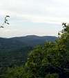
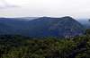
This mountain sits just to the South of Breakneck Ridge. Its Western flanks were once the site of extensive quarrying in the early 1900's and many remains of this activity can be found. Old buildings, concrete roads, stone walls, and the quarries themselves remain throughout the area. There is lots to explore in this aspect without even much climbing. But a climb to the summit provides excellent views of the surrounding highlands, the Hudson River, Constitution Marsh, and even the sky scrapers in New York City. The mountain supposedly gets its name from an errant bull chased through it by local farmers, the same bull whose end in a fall also gave Breakneck Ridge its name.
Getting There
 Map not for navigation!
Many trails are found along Rt 9 and almost any of them can get you to Bald Hill. The choice you make simply relates to how hard a hike you want or how much time you have.
From NYC take the George Washington Bridge to the Palisades Interstate Parkway (going north). Take the Palisades Interstate Parkway for about 40 miles until its end at the Bear Mountain Bridge. Cross the Bear Mountain Bridge and make a left onto Route 9D (north).
Take Route 9D north for about 11 miles passing through the town of Cold Spring. About two miles north of Cold Spring you will drive through an underpass. Park on the roadside just north of the underpass (GPS: N 41.44354, W 073.97791). Or there is a parking area and trail in Cold Springs across from the trail to Stony Point.
The total driving time is estimated at one hour without traffic.
As you can see from the map there are many trails in the Highlands and lots to enjoy!
Red Tape
Seasons/Hours:Park is open daily, sunrise to sunset. Hunting: Deer hunting (bow only) and spring turkey hunting (shotgun only) is permitted in season. A New York State Hunting License as well as a Park Permit is required. Please call the Park Office for more details.
Pets:
Dogs are permitted on trails, on a leash of not more than 10 feet.
Camping:
No camping or fires are allowed.
My Route
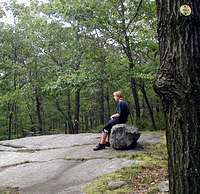 Taking a break
When I climbed I started by climbing the white trail up Breakneck Ridge, near the summit a Yellow (Undercliff) trail comes in to the South. We took the yellow trail into the col between the two mountains. The trail skirts some steep cliffs, the results of mining early in the 1900's. The yellow trail eventually come to the Red Trail, here we turned left or north to the Blue (Notch) trail. Go past the Blue trail a short distance to the remains of the Cornish Estate. This old farm is a lot of fun to explore. The stone work is amazing for something that was a home for cows. Retrace back to the blue trail and head east on it, the climbing is not steep but is steady. Eventually the trail turns sharply to the south/southwest. Soon there will be an unmarked yellow trail, do not take it. Continue ahead and finally to the junction of the green (Nelsonville ) Trail and the white (Washburn)trail. Continue straight on the white trail (the blue trail ends here). Soon you'll be on the summit with views north over breakneck and the Fishkill Ridge. continuing on the white trail around the summit and you'll find other views south towards Bear Mountain, West Point, Manhattan, etc. Continueing on the white trail you eventually will reunite with teh yellow trail with scattered views all along the way. We followed the yellow back to the Red Trail and then took the red trail back to RT 9 and carefully walked the road the short distance back to the tunnel and parking are.