
-
 14494 Hits
-
 83.1% Score
-
 16 Votes
|
|
Mountain/Rock |
|---|---|
|
|
42.04448°N / 73.49274°W |
|
|
Dutchess |
|
|
Hiking |
|
|
Spring, Summer, Fall, Winter |
|
|
2311 ft / 704 m |
|
|
Overview

Located in southeastern New York at the point on the border with Connecticut and Massachusetts (where those two states meet) and within the Taconic State Park lies Brace Mountain. The mountain is located in the Taconic Mountain Range which itself forms a narrow strip of peaks between the Adirondacks and Green Mountains in the north and the Catskills and Berkshires in the south. All ranges lie within the Appalachian Mountains. The Appalachian Trail passes about 2 miles to the east of Brace Mountain but one could connect to it via the Mt. Frissell Trail that links those two peaks and continues on over Round Mountain and then to Bear Mountain which the AT passes over. The South Taconic Trail passes over Brace Mountain running north/south.
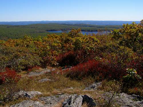
There are several summits on the ridge that makes up Brace. The high point is 2311 feet and is the highest point in Dutchess County, New York. A prominent subsummit, known as South Brace Mountain, is 2304 feet and is the next bump south from the main summit and just a short hike away (with better views to the south). The South Taconic Trail connects the two summits along with the lower mound to the north (where one connects to a multitude of trails going in all directions). The summits are Appalachian balds covered mostly in grasses or shrubs with the lower slopes of Brace covered in mostly hardwood species. This area falls within the Taconic State Park and is designated as one of America's "Last Great Places" by the Nature Conservancy. Views to the north include other Taconic Peaks, to the west are the Catskills and Shawangunks, to the east lies more Taconics including Mt. Frissell and Round Mountain and to the south is lovely Riga Lake in the Mount Riga Forest Preserve.
A huge cairn sits atop the summit and there is no mistaking it. There are a multitude of ways to hike up Brace Mountain. You can start from the Mt. Frissell Trail in the east. One could start from the north on Alander Mountain/South Taconic Trail and head south to connect with the Mt. Frissell Trail (farther north you can access this trail from Copake Falls State Park). You can also access it from the south via the South Taconic Trail. This area makes for an enjoyable way to bag peaks in 3 different states if you want.
Beware that this peak is utilized by the Mt. Brace Outdoor Club for paragliding and hang gliding so don’t be surprised to maybe see some foot pilots up trudging their stuff up sometimes.
Getting There
These directions are for the route for the Mt. Frissell Trail approach (eastern trail).
If coming from the northeast:
(read these carefully first)
Take Massachusetts Turnpike to the Stockbridge exit (W Road), turn left onto W Road and go short distance to Sockbridge Road. Take a right on Stockbridge Road/Lee Rd. and drive to the fork in the road, veering right and staying on Lee Road. Go 2 blocks to East Street (Route 7) and go left on Rt. 7 through the town of Stockbridge. Following signs for Highway 7 you will turn left at the Red Lion Inn. Continue on Rt. 7 to Great Barrington. Route 7 becomes also Route 41 and in ot slightly after Great Barrington you need to switch and start following signs for Route 41 (it will be a right fork in the road, also known as Maple Ave). Then follow Route 41 on and through the town of South Egremont. Route 41 will at this point also be Route 23 and these roads will then split off from each other. Just after this split (and staying on Route 41) turn right onto Mt. Washington Road. Stay on Mount Washington Road until it splits and take the left fork (East Street). Staying on East Street you will go past the Mount Washington State Reservation on your right and shortly the road will turn into a dirt road. Keep your eyes peeled here for a sign on the left side of the road and a state border marker sticking up out of the ground. It's easy to miss so make sure you are specifically looking at all places where you think there is a pullout to park in and you should be able to spot it. Park on the right side of the road (west) at the trailhead-room for a few cars. Do not park on the other side of the road in the pullout area-it is a tow zone.
If coming from the northwest:
Also take the Mass Pike but to the exit for Route 41 to Great Barrington. Follow Route 41 into Great Barrington and continue as above.
From the south:
Take Route 41 north to South Egremont and then same as above.
If you would like to access the South Taconic Trail from the north in Copake Fall State Park, please see directions on this website.
Red Tape
None from the Mt. Frissell Trail approach.From the Copake Falls State Park:
there could be a fee involved
Camping

You are only supposed to camp in the Taconic State Park at approved campgrounds (open May 7 - October 23). The park is open sunrise to sunset daily weather permitting.
Information here
Website for making camping reservations in Copake Falls State Park
Virtual Tour Taconic State Park
Mountain Conditions
Taconic State Park - Copake Falls Area
(518) 329-3993
Maps
South Taconic Trails MapLink to how to order for only one, tiny down payment of $4.95 plus $1.20 postage/handling! Get yours TODAY!!!!
Online Version
Click on the map to make it larger.