
|
|
Area/Range |
|---|---|
|
|
40.54303°N / 75.20142°W |
|
|
Hiking |
|
|
Spring, Summer, Fall, Winter |
|
|
Overview
 Mid-Atlantic Highlands
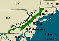
From the Housatonics in Connecticut to the Michaux State Forest in Pennsylvania, the Mid-Atlantic Highlands region of New York, New Jersey, Pennsylvania, and Connecticut forms a 3.5 million acre greenbelt around the sprawling areas of Philadelphia, New York City and Hartford.
The Mid Atlantic Highlands are part of the Appalachians. The region is located from south-central Pennsylvania through New Jersey and New York to northwestern Connecticut, forming a vital linkage between the Berkshires to the north and the Blue Ridge Mountains of the south.
Here, forested ridges make up rolling hills and mountains of green across the horizon. There are many lakes, ponds, streams, rivers and reservoirs. Rocky crags and deep forest offer wild and untamed habitat to a large variety of wildlife. There are clear cold streams in which native trout breed, and the forests are home to black bear, river otters and bobcat. More than 14 million people visit the Highlands annually, more than Yellowstone and Yosemite National Parks combined.
The Mid Atlantic Highlands are seen as "a landscape of national significance," by the US Forest Service, and as a "Special Resource Area" by the State of New Jersey, vital open spaces in the Highlands are increasingly being lost to suburban sprawl, including over 5,000 acres annually in the NY-NJ Highlands alone. The future of this region of water, beauty and life is in jeopardy.
The "backyard" to the New York-Philadelphia-Hartford metropolitan area, the Mid-Atlantic Highlands offer more than 200,000 acres of public open space, these Highlands host more than 14 million recreational visits annually.
Several trails traverse the region, including the Appalachian Trail, Long Path and Highlands Trail.
Over 100 plants and almost 50 animals listed as Federal or State endangered, threatened or species of concern make their home in these Highlands.
The region provides critical wildlife habitat for more than 70 species of migratory songbirds and species such as black bear, bobcat, beaver, otter, and trout.
Map overview
 Mid-Atlantic Highlands
Connecticut Areas
Summit Post pages in CT
Bear Mountain At 2316 it is the tallest mountain entirely within state bounderies.
Mt Frissell Holds CT's highest elevation at 2380 but the summit itself is not in Connecticut.
Sleeping Giant Yes it looks like a sleeping giant
Connecticut Climbing Areas
Devils Den
Saint Johns Ledges
Other Areas
Schenob Brook Watershed (Litchfield Co.)
One of the finest calcareous fens in New England. The 2230 acres of the main wetland portions of the lowland swamps have remained undeveloped and were nominated for designation as a federal area of environmental concern in 1990.
Canaan Lime Cliffs (Litchfield Co.)
Carbonate bedrock is rare in New England, restricted to relatively small portions of western Vermont, Massachusetts, and Connecticut. Many unusual plants and wildlife rely on the calcium-rich soils and limestone outcrops in the Highlands.
Canaan Mountain (Litchfield Co.)
The higher elevations of Canaan Mountain are owned by relatively few owners with large landholdings. The Connecticut Department of Environmental Protection has purchased considerable acreage and has recently expressed interest in protecting approximately 1123 water company acres. Additionally, the Yale School of Forestry operates a demonstration forest with the permission of one landowner.
Farmington River Wild and Scenic Area (Litchfield Co.)
The Farmington River Wild and Scenic Area winds through the Highland towns of Colebrook, Hartland, Barkhamsted, New Hartford, and Canton.
Housatonic River Greenway (Litchfield Co.)
This corridor has been officially designated a Greenway by the State of Connecticut. It extends from the Highlands region to the Long Island Sound.
Macedonia Brook Watershed (Litchfield Co.) The watershed of Macedonia Brook encompasses several thousand acres of unbroken forest. The Macedonia State Park provides a foundation for additional land protection to provide extensive fish and wildlife habitat.
Stanley Works Scenic Area (Litchfield Co.) This tract along the east shore of the Housatonic River encompasses approximately 600 acres in the towns of Cornwall and Kent. Although a portion of the tract is protected under a federal scenic easement, the two towns, local land trusts, and the Connecticut Department of Environmental protection are working to preserve the entire parcel.
Shepaug Watershed (Litchfield Co.)
Until the late 1970s, the City of Waterbury permitted a stretch of the Mattatuck Trial to pass through several thousand acres of watershed lands associated with the Shepaug Reservoir. Permanent protection of these lands along with reopening the trail would guarantee water quality along with the potential to create linkages to the Shepaug River Greenway.
Bull’s Bridge Scenic Area (Litchfield Co.)
The Bull’s Bridge hydropower Development, located in the towns of Kent and New Milford. Protecting these lands would augment 400 acres of federally-protected Appalachian Trial corridor. This unusually large undeveloped forested riparian area contains numerous critical habitats for rare species.
Shepaug Greenway (Litchfield Co.)
Extending along the river from its source to the confluence with the Housatonic River, the area protects open spaces and important habitats in the Shepaug River watershed. This corridor has been officially designated a Greenway by the State of Connecticut.
New York Areas
Summit Post pages in NY
Schunnemunk Mt. Highest point in Orange County at 1664 ft.
Mount Beacon Second Highest point in the Hudson Highlands at 1610 ft.
Lambs Hill Part of the Fishkill Ridge
Bull HillIts Western flanks were once the site of extensive quarrying in the early 1900's and many remains of this activity can be found.
Mt Egbert Part of the Appalachian Trail
Storm King The mountain's most striking feature is its east face, which rises over 1,300 ft from the Hudson River to the summit.
Bear Mountain Birthplace of the Appalachian Trail
Breakneck Ridge One of the finest NY hikes
Long Mountain It is not very high but offers awesome views of Harriman and Bear Mtn. State Parks, West Point, and the surrounding countryside.
Popolopen Thorne Popolopen Torne is a small steep crag that offers steep hiking and scrambling.
Sugarloaf Mountain Part of the Hudson Highlands State Park
Anthony's Nose At approximately 900 feet, it is one of the smaller hills in the area, but offers great views from its summit.
Other NY Areas
Taconic Ridge (Dutchess Co.)
The southern end of the Taconic Ridge is anchored by the Cranberry Mountain State Wildlife Management Area and extends through eastern Dutchess County along the Connecticut border, west to include the Harlem Valley, and north to the Taconic State Park.
Great Swamp (Putnam & Dutchess Co.)
The largest and highest quality red maple hardwood swamp in southern New York is located in the Towns of Pawling and Dover (Dutchess Co.) and Patterson and Southeast (Putnam Co.). Large parts of the Great Swamp's 63,000-acre watershed have been identified by the Forest Service as a Highlands Conservation Focal Area.
Hudson Highlands/Fahnestock Link (Putnam Co.)
Located in the northwest/central portion of Putnam County and the southern edge of Dutchess County, this area contains large blocks of nearly contiguous upland forests. The 14,000-acre Clarence Fahnestock Memorial State Park in Putnam County, much of which has been undisturbed for over 100 years, provides exceptional ecological and recreational value. More than 10,000 acres of the park have been designated as a Bird Conservation Area and the Appalachian National Scenic Trail passes through the park. Fahnestock lies in close proximity to Hudson Highlands State Park, which encompasses 5,500 acres, including Bull Hill and parts of Breakneck Ridge. This area connects the Appalachian Trail to Anthony’s Nose and to the Camp Smith Trail extending into Westchester County. The Forest Service has identified this as a Highlands Conservation Focal Area.
Goosepond Mountain Link (Orange Co.)
Lands adjacent to the 1,500-acre, wooded Goosepond Mountain State Park in Chester, Orange County, are threatened by immediate and intense development pressure. Goosepond Mountain is also part of the Moodna Creek Watershed, which is a biodiversity hotspot (see Schunnemunk Mountain/Moodna Creek/Woodcock Mountain for more info).
Ramapo Mountains and Ramapo River Watershed (Orange & Rockland Co.)
The Ramapo Mountains are Rockland County’s Highlands, and parts of the Ramapos are permanently protected as Harriman State Park. The Forest Service has identified this as a Highlands Conservation Focal Area.
New Jersey Areas
Summit Post pages in NJ
Wawayanda MountainWawayanda (wa-wa-yanda) is an old Indian word meaning "winding waters".
Pochuck Mountain The rocks that lay around and on top of the mountain are over a billion years old.
Osio Rock Osio Rock is the southernmost hill accessed by a trail in Norvin Green State Forest.
Wallkill River Valley (Sussex Co.)
The federally endangered bog turtle makes its home in and adjacent to the Wallkill National Wildlife Refuge. Many habitat sites are threatened with development, with immediate preservation needed.
Pequannock Watershed (Passaic, Sussex and Morris Co.)
The wilderness core of the NJ Highlands, and its largest unprotected forest tract, holds enormous biological value and is home to hundreds of bear, native trout, bobcat and rare interior forest bird species. Much of the watershed has been held by the City of Newark since the early 20th century to safeguard its water supply. However, development proposals have been floated by Newark, and numerous inholdings are threatened as well.
Wyanokie Highlands/Wanaque Watershed (Passaic Co.)
The Wyanokie Highlands form the headwaters of Burnt Mill and West Brooks that flow into North Jersey's Wanaque Reservoir, which provides drinking water for nearly two million NJ residents. Completion of a critical greenway in the Wyanokies linking Long Pond Ironworks State Park with Norvin Green State Forest
Ramapo Mountains and Ramapo River Watershed (Bergen & Passaic Co)
At the eastern edge of New Jersey's Highlands, the Ramapo Mountains delineate where the pavement ends and nature begins.
Farny Highlands (Morris Co.)
Northern Morris County's forested Farny Highlands form the headwaters of five rivers and make a significant water supply contribution. While the state and county have made progress in preserving important areas, many significant tracts remain in jeopardy.
Sparta Mountain Greenway (Sussex & Morris Co.)
Along the westernmost ridge of New Jersey's Highlands, a continuous stretch of undeveloped mountain connects Hamburg Mountain Wildlife Management Area to Allamuchy State Park. Sparta Mountain and Weldon Brook WMA's form its core.
Scotts Mountain (Warren Co.)
Scotts Mountain, the largest contiguous forest area in southern Warren County, was identified by the US Forest Service as an "Important Area" in its 1993 regional study. It provides critical habitat for forest interior-dependent bird species in the southern New Jersey Highlands.
Pohatcong Mountain/Pohatcong Grasslands (Warren Co.)
The grasslands, a priority one heritage site, are home to numerous threatened and endangered species of birds. Two thirds of the region is completely unprotected and is under extreme pressure from development. Pohatcong Mountain is a linear forest island that links outstanding bluffs along the Delaware River with the Musconetcong Valley.
Musconetcong Mountain (Hunterdon Co.)
The mountain was identified in 1993 by the US Forest Service as an "Important Area" of the Highlands, because of its forest, wildlife, water and recreational values. Framing the beautiful agricultural Musconetcong Valley, the ridge stretches across Alexandria, Holland, Bethlehem and Lebanon Townships.
Pennsylvania Areas
Summit Post pages in PA
Hawk Point Located within the confines of Susquehannock State Park
Mt. Pisgah Mount Pisgah is one of the highest and most picturesque summits in York County and provides an excellent vantage point from which to see the Susquehanna River.
Snowy Mountain It is not huge when compared to mountains around the world but it is a beautiful place to enjoy PA's rolling mountain scenery.
Buzzard Peak Buzzard Peak is located in the southern portion of Michaux State Forest and shares a saddle with its' larger neighbor, Snowy Mountain .
Rocky Knob Resting within the confines of Michaux State Forest , this mountain lies within the South Mountain Massif to the west of Gettysburg.
Hammonds Rocks Hammonds Rocks is another of the many great summits within Michaux State Forest on South Mountain.
Little Rocky Ridge/ Sunset Rocks The most popular attraction to this summit is Sunset Rocks which is a large outcropping on the eastern side of the ridge that affords wonderful views in a 240 degree panorama.
Pole Steeple Pole Steeple is a part of the very large South Mountain Group located within Pine Grove Furnace State Park and just west of Gettysburg.
Other Areas in PA
Bougher Hill (Northampton Co.)
Bougher Hill is the site of the Mariton Wildlife Preserve and consists of meadows, forested rocky ridges, woodlands and springs. These resources serve as habitat for woodland birds and breeding areas for amphibians. The Preserve features a nature center and affords an excellent view of the Delaware River.
Durham Mine/Mine Hill/Rattlesnake Hill (Bucks Co.)
This ridge represents a spur of the Reading Prong separated from the main mass of the Prong by the limestone valley containing Cooks Creek. The site consists of extensive north-facing forested slopes extending for about two miles. Iron ore from Mine Hill supplied the early forge at Durham. The abandoned mine has become the second largest bat hibernaculum in Pennsylvania. The 150-175-acre forest that covers the slopes of Mine Hill and Rattlesnake Hill provides habitat for 62 bird species, including ten rare breeders.
Haycock Mountain (Bucks Co.)
The State Game Lands (#157) on Haycock Mountain and Nockamixon State Park together constitute the largest expanse of protected open space in Bucks County (7,000 acres). Three rare plant species and 47 species of birds, including five rare breeders, make their home on the diabase outcrops and forests of the Mountain.
Lower Lehigh Valley Reach of the Lehigh River (Northampton & Lehigh Co.) formerly named Lehigh Canal & Corridor Greenway
The 15-mile reach of the Lehigh River that runs east from Allentown through Bethlehem to its confluence with the Delaware River in Easton has a remarkably wild aspect in spite of the fact it runs through the urban heart of the beautiful Lehigh Valley. This reach defines the precise edge of the core of the Pennsylvania Highlands – South Mountain.
South Mountain (Northampton Co.)
South Mountain is the name given locally to the ridge of hills extending from Easton to Reading, a distance of some 45 miles. The hills are wooded and rolling, with some cleared areas for farming and increasing residential development. Much of the present water supply for a number of communities in eastern Pennsylvania flow from these hills, including the city of Allentown.
Hosensack Swamp (Lehigh Co.)
This 100-acre wetland in the Hosensack Valley contains established populations of rare and endangered animals and was given the highest priority rank in the Lehigh and Northampton County Natural Areas Inventory.
Unami Hills and Ridge Valley Creek (Montgomery & Bucks Co.)
The Unami Hills region of northern Montgomery County is part of a diabase rock formation that stretches across Bucks and Montgomery Counties. These rocky, wooded ridges form a conspicuous band of forest two to three miles wide from the Delaware River to central Montgomery County, including the Unami Creek Valley and that of the adjacent Ridge Valley Creek. The diabase zone constitutes the largest contiguous tract of forest remaining in these two counties, and provides important habitat for forest interior birds such as pileated woodpeckers, songbirds and other species that require large blocks of unfragmented forest.
Mt. Penn & Neversink Mountain (Berks Co.)
Mt. Penn and Neversink Mountain provide a scenic backdrop for the city of Reading, located at the southwestern tip of the Reading Prong. Long considered a natural and recreational area for the Reading region.
Stone Hill (Montgomery Co.)
Stone Hill, sister mountain to Spring Mountain, is the beginning of a wooded landscape that densely covers Marlborough and Salford Townships in Montgomery County, and a portion of Bucks County.
Great Marsh (Chester Co.)
Chester County’s Great Marsh is part of the Delaware River watershed and consists of over 3,400 acres in the townships of East Nantmeal, West Nantmeal and Wallace. The Great Marsh is the largest, most biologically rich inland freshwater marsh in the eastern part of the state; the Commonwealth of Pennsylvania classifies it as an Important Bird Area and an Exceptional Value wetland. 155 bird species live here including the short-eared owl (state endangered), least bittern (state endangered), pied-billed grebe, marsh wren and Wilson’s snipe. The Great Marsh serves an important migration corridor with over 30 warbler species (including the prothonotary warbler, Cape May warbler, palm warbler, bay-breasted warbler, Wilson’s warbler and Canada warbler) passing through. In addition, the area is important for Pennsylvania Species of Special Concern such as the black dash butterfly, mulberry-winged skipper. Deer, muskrat, fox and mink live here also.
Historically, Great Marsh was burned by Native Americans and later farmed by early colonial settlers.
The potential for recreation here is great with opportunities for hiking, canoeing, biking, birding and hunting.
Welsh Mountain (Lancaster Co.)
Welsh Mountain is a long ridge in eastern Lancaster and northwestern Chester counties that rises about 1,000 feet above Amish farmland.
Furnace Hills (Lancaster Co.)
The Horseshoe Trail extends the length of the Furnace Hills and serves as a major recreational attraction. The trail was once used to transport goods to and from the numerous iron furnaces and forges in the Pennsylvania Highlands. State Game Lands in the Furnace Hills also provide outdoor recreation activities such as hiking, boating, fishing and hunting.
Narrows (Adams Co.)
The Narrows, one of Adams Co.’s most scenic areas, consists of about 3000 acres of quality forest habitat with mossy seeps and many older hemlocks and white pines on the higher slopes. It is named for its water gap, which reaches 680 feet and contains gray-green metarhyolite outcrops which support several plant species of conservation concern.
External Links
Highlands Regional Information System (HiRIS)Appalachian Mountain Club Highlands Conservation
Highlands Coalition
Fishkill Ridge Caretakers
Housatonic Valley Association
NY/NJ Higlands