
-
 25053 Hits
-
 80.78% Score
-
 13 Votes
|
|
Mountain/Rock |
|---|---|
|
|
39.83400°N / 77.494°W |
|
|
2062 ft / 628 m |
|
|
Overview
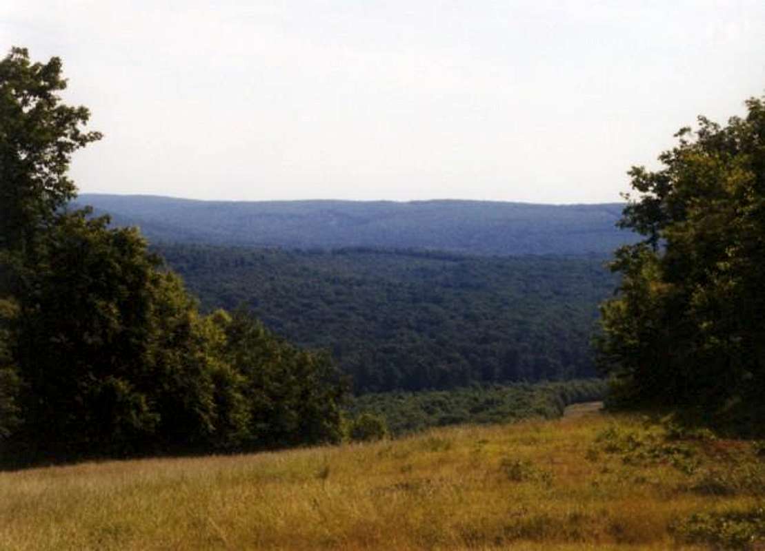
Snowy Mountain is the central mountain of the Michaux State Forest and is also the highest. As you can tell, its' height for Pennsylvania is up there pretty well. It is not huge when compared to mountains around the world but it is a beautiful place to enjoy PA's rolling mountain scenery. The little range in which this mountain is found, is a continuation of the South Mountain chain which stretches north from Virginia. The Appalachian Trail also runs through Michaux State Park for about 40 miles and it crosses Snowy Mountain just below its' summit. The origins of Snowy Mountain's name is unknown but I might have an idea about that. The entire summit ridge is covered in white quartz along with some that has formed into crystals. Some of the quartz is mixed into conglomerate which makes for many interesting designs as well which may have lead to the mountain's name.
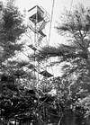
Snowy Mountain also has a watch tower on the summit which is mostly used for fire watch. As far as I know, the tower is not open to the public, but if anyone knows anything about that, feel free to let me know. The mountain is conveniently located 15 miles from Gettysburg and 4 miles from Waynesboro as well. In being connected to its' lower neighbor, Buzzard Peak , Snowy Mountain is usually done along with Buzzard in either a loop, or an up and back trip. The area is famous for it's many rock outcroppings and climbing hottspots, the most famous of which is Schaffer Rock, located in the ravine on the south side of Snowy. Many possibilities abound and can be put to work with a trip to Snowy Mountain and the views are well worth while along with the large amount of wildlife.
 |
Getting There
The most common places of entry are from Gettysburg and Waynesboro.
From the east (Gettysburg):
• From U.S. route 15 get off onto the York St. or Route 30 (Lincoln Highway) exit for Gettysburg. Take 30 west through town and continue for fifteen miles into Michaux State Park. You will then reach the highway 233 jct. and you'll want to head south. Continue for six miles to either the town of South Mountain (for the southern A.T. trailhead) or turn right and continue onto route 233.
• From South Mountain: head east on Cold Spring Road through town and then after approximately two miles turn right onto Old Forge Road and continue to the Appalachian Trail sign which is the trailhead for the southern approach (on the north side of the road). There is parking available.
• From 233 (northern trailhead): After turning right at the intersection the A.T. sigh is only .3 miles on the left side of the road. The trail on the south side of the road is the trailhead for the northern approach.
From the west (Waynesboro):
• From town head east on highway 36 for about 1.75 miles and turn left onto Old Forge Road. Follow this road until you reach the Appalachian Trail sign. You'll want the trail on the left side (north side) of the road.
Interstate 81 access:
• From either direction on I-81, get off onto the exit for highway 233 and follow the directions listed above.
 |
Red Tape
There are no permits or fees required for hiking in Michaux State Park. It is open all year round with possible road closures during the winter. All State conservation rules apply for garbage and pack it in, pack it out rules. Follow the Leave No Trace system and you'll be fine. Free parking is available at both trailheads. There is room for probably five cars, but don't worry as there shouldn't be herds of people in your way.
When To Climb
This mountain is climbable during all times of the year. Fall and early Winter would be the best for views because of turning leaves or the lack there of them. In snow and ice conditions, crampoons may be needed. This mountain is an excellent summer hike as well with lots of wildlife to view along the way.
Camping
There are many places within the Michaux State park to camp, but you'll want to contact the park office at (717)352-2211. They'll get you information about all available camping areas in the park.
For more park information go to:
www.dcnr.state.pa.us/forestry/forests/michaux.htm
You can also write to:
Michaux State Forest
10099 Lincoln Way East
Fayetteville, PA 17222-9609
Shelters:
There are three shelters within the immediate area of Buzzard Peak. The closest is Tumbling Run Shelter which has two shelters, a spring, and a bathroom. It is maintained by the Potomac Appalachian Trail Club as are the other two. The other shelter is Hermitage Cabin which is on reservation from the PATC. You can call their offices at (703) 242-0965. Also on the other side of the road from the trailhead is Antietam Shelter which is similar to the Tumbling Run Shelter. Tumbling Run and Antietam Shelters are good for emergency use throughout all times of the year.
 |
Mountain Conditions
For current and up-to-date weather conditions click on the link below!
weather.com
External Links
- Potomac Appalachian Trail Club
This page is from the PATC and gives information on the stretch of trail maintained by the PATC as well as trail guides and publications.
- Appalachian Trail
This is the official website of the Appalachian Trail from Maine to Georgia. It contains lots of useful information about the trail.
- Michaux State Park
This page contains all provided information by the state of Pennsylvania about Michaux State Forest and Park.
Cascade Scrambler - Jun 2, 2011 11:07 am - Hasn't voted
Correct Michaux State Forest LinkYour link to Michaux State Forest is broken. It should be: http://www.dcnr.state.pa.us/forestry/stateforests/michaux/index.htm
realdeal577 - Dec 21, 2013 5:19 am - Voted 6/10
No viewsThere are no views at the summit and the fire tower is locked.